Widespread life-threatening flash and urban flooding continues in south-central Texas, with considerable flooding impacts possible across central Texas. Wildfire smoke is impacting air quality across much of the Great Lakes region into southern New England and the Mid-Atlantic. Monsoonal thunderstorms may produce isolated to scattered flash flooding across the Southwest into the Great Basin. Read More >
Overview
An easterly flow of moist, unstable air was in place across the High Plains. Easterly flow brought this instability to the foothills of the Rockies where numerous thunderstorms developed in the afternoon and early evening. Winds aloft where out of the west in excess of 60 mph, creating strong wind shear needed for severe thunderstorms to develop. Several rotating storms called supercells formed in eastern Colorado causing baseball size hail, at least 1 tornado and a measured 97 mph wind gust at the Burlington airport. The image below is a visible satellite image taken at 201 PM MDT. If you look close you can see an area of developing cumulus over the Goodland area that would represent the area of strongest instability, where the strongest storms eventually moved along.
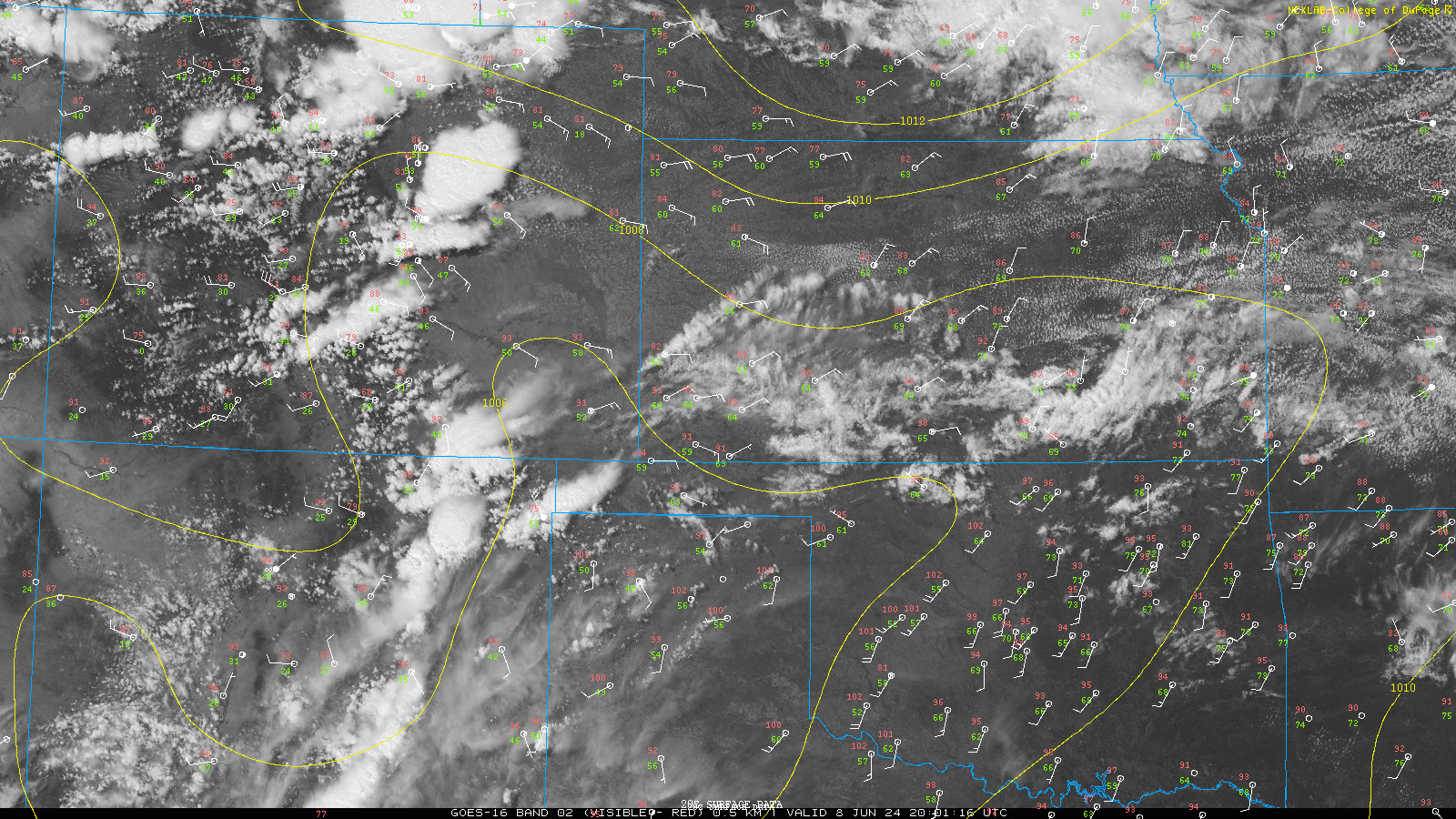 |
| 2 PM MDT GOES East Visible Imagery, MSLP and surface obs. Image from College of Dupage |
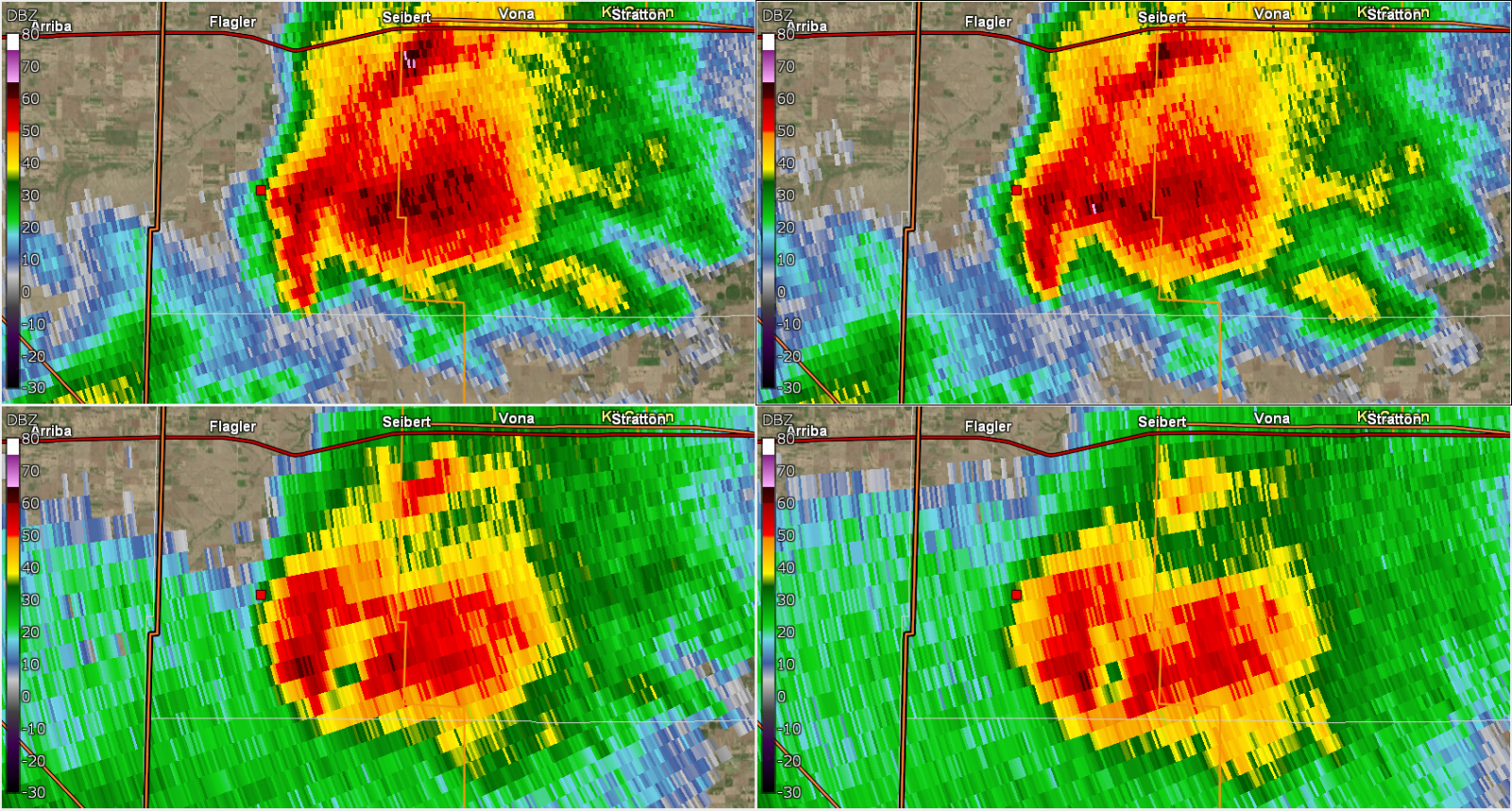
Tornado:
|
Tornado - Southwest Kit Carson County
|
||||||||||||||||
The Enhanced Fujita (EF) Scale classifies tornadoes into the following categories:
| EF0 Weak 65-85 mph |
EF1 Moderate 86-110 mph |
EF2 Significant 111-135 mph |
EF3 Severe 136-165 mph |
EF4 Extreme 166-200 mph |
EF5 Catastrophic 200+ mph |
 |
|||||
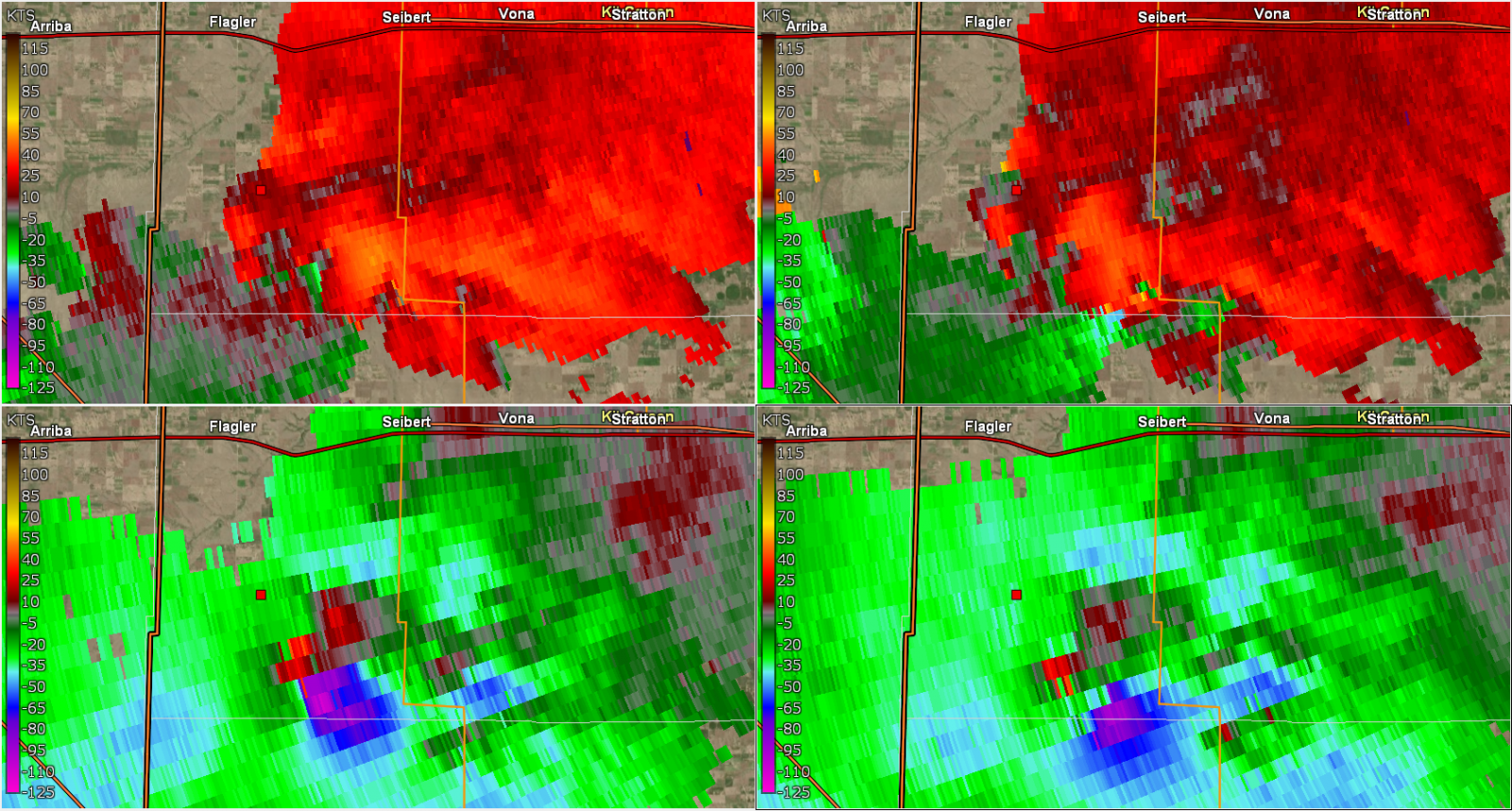
Wind:
|
Straight Line Winds - South of Burlington
|
||||||||||||||
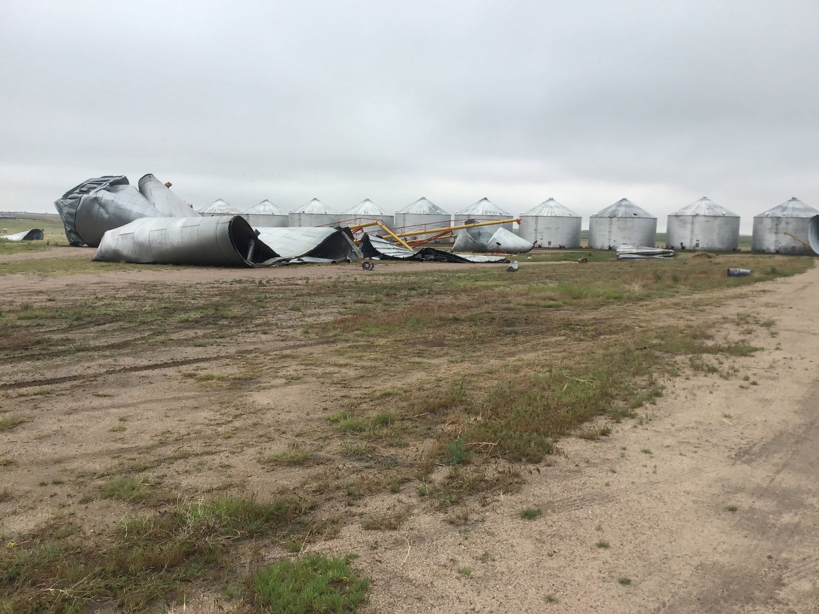
Wind Damage
 |
 |
 |
 |
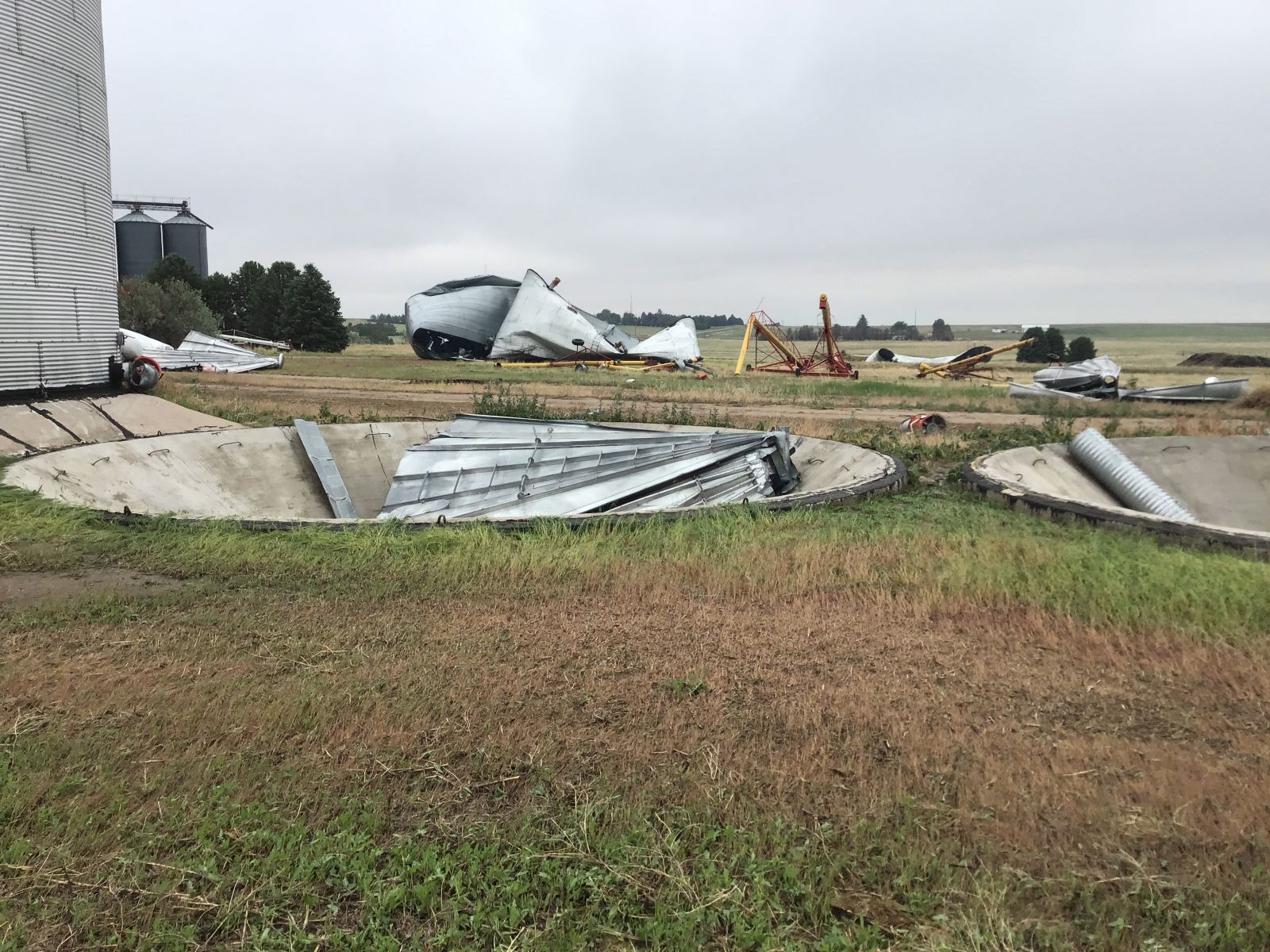
| Six 35 ft wide grain bins were torn off their foundations with debris scattered up to 850 ft away. Source: NWS Damage Assessment |
Two of grain bin bases with the bins seen in the distance. Source: NWS Damage Assessment |
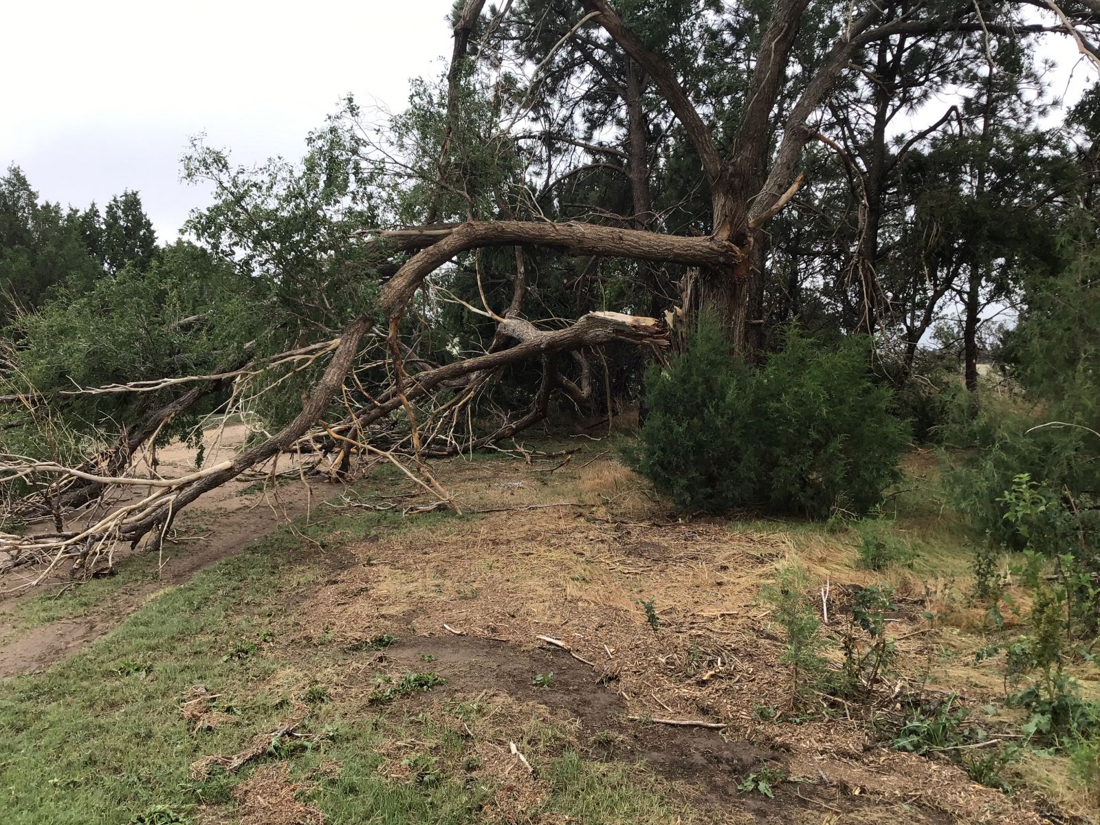
One of the larger branches to be found broken off a healthy tree. Source: NWS Damage Assessment |
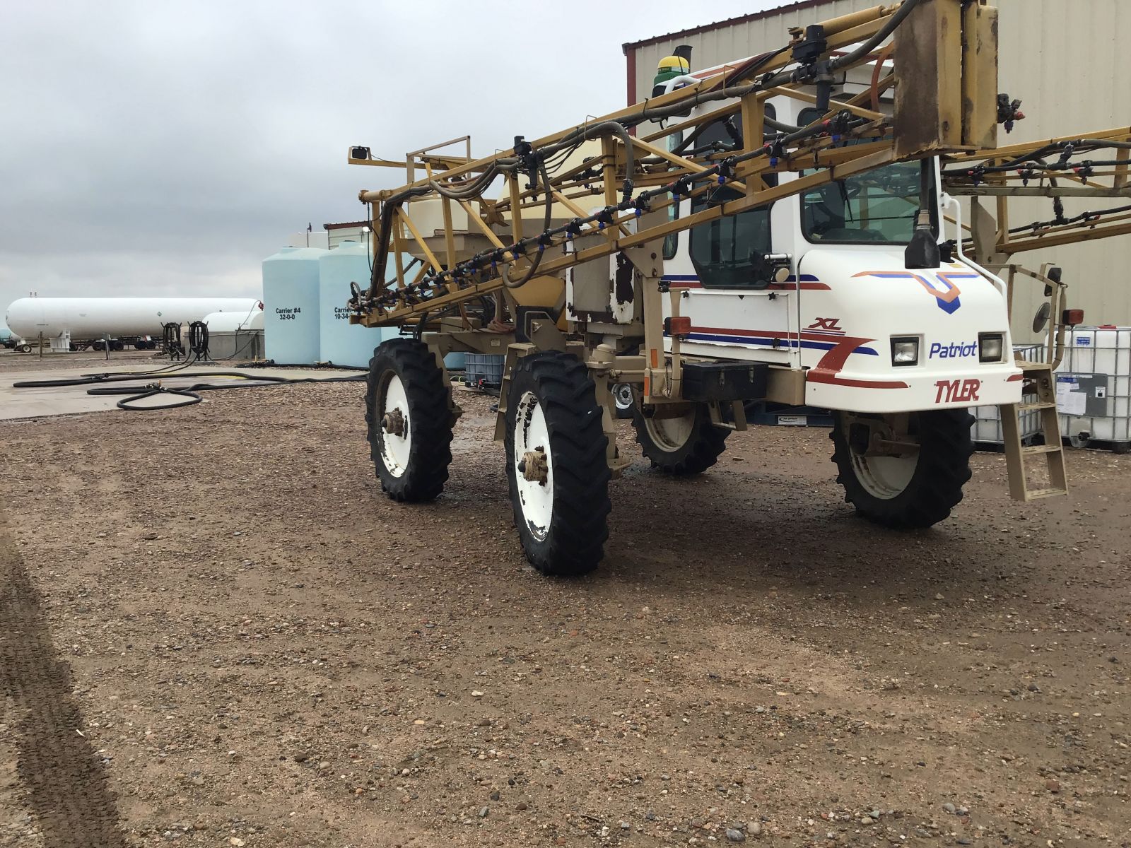
A sprayer was pushed by the wind 25 ft from where it was parked by the concrete pad. Source: NWS Damage Assessment |
Photos
 |
 |
 |
 |
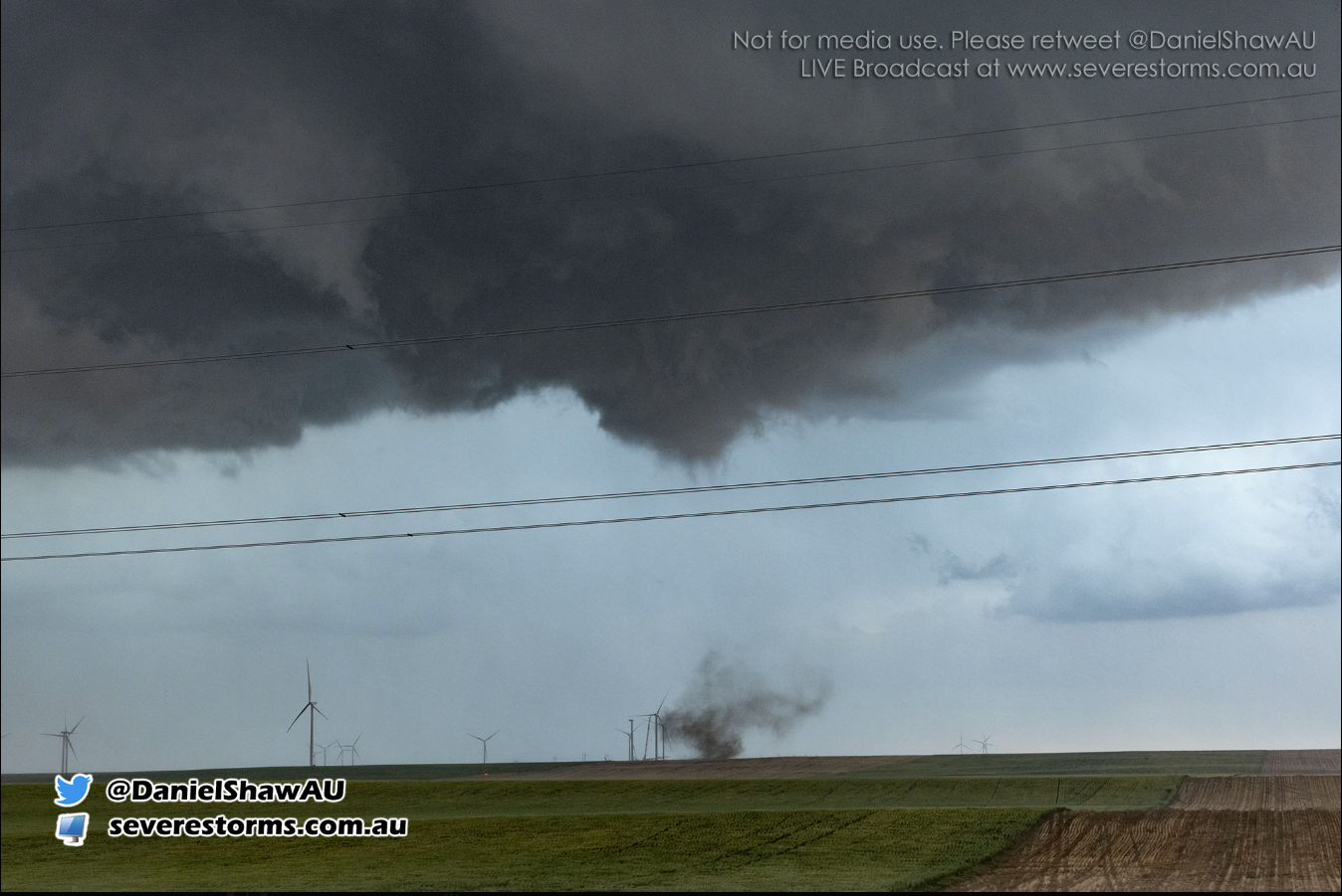
| Short-lived tornado that occurred in Southwest Kit Carson County. Source: Daniel Shaw |
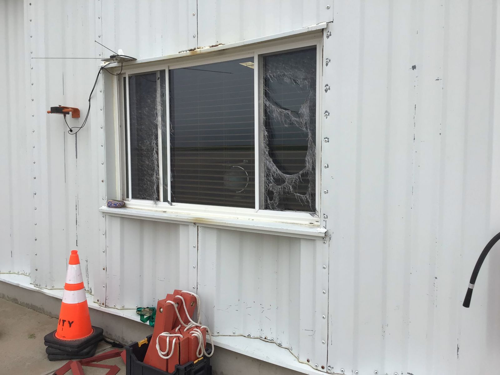
Straight line winds shredded the screen on west-facing windows at the Burlington Airport. Source: NWS Damage Assessment |
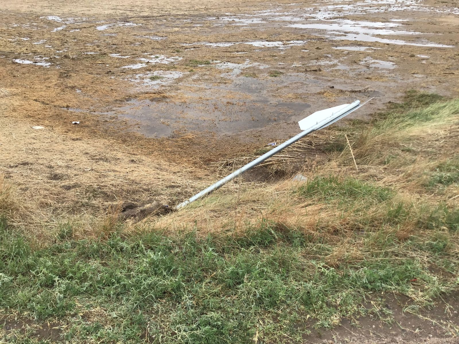
The stop sign was blown over by straight line winds. Source: NWS Damage Assessment |
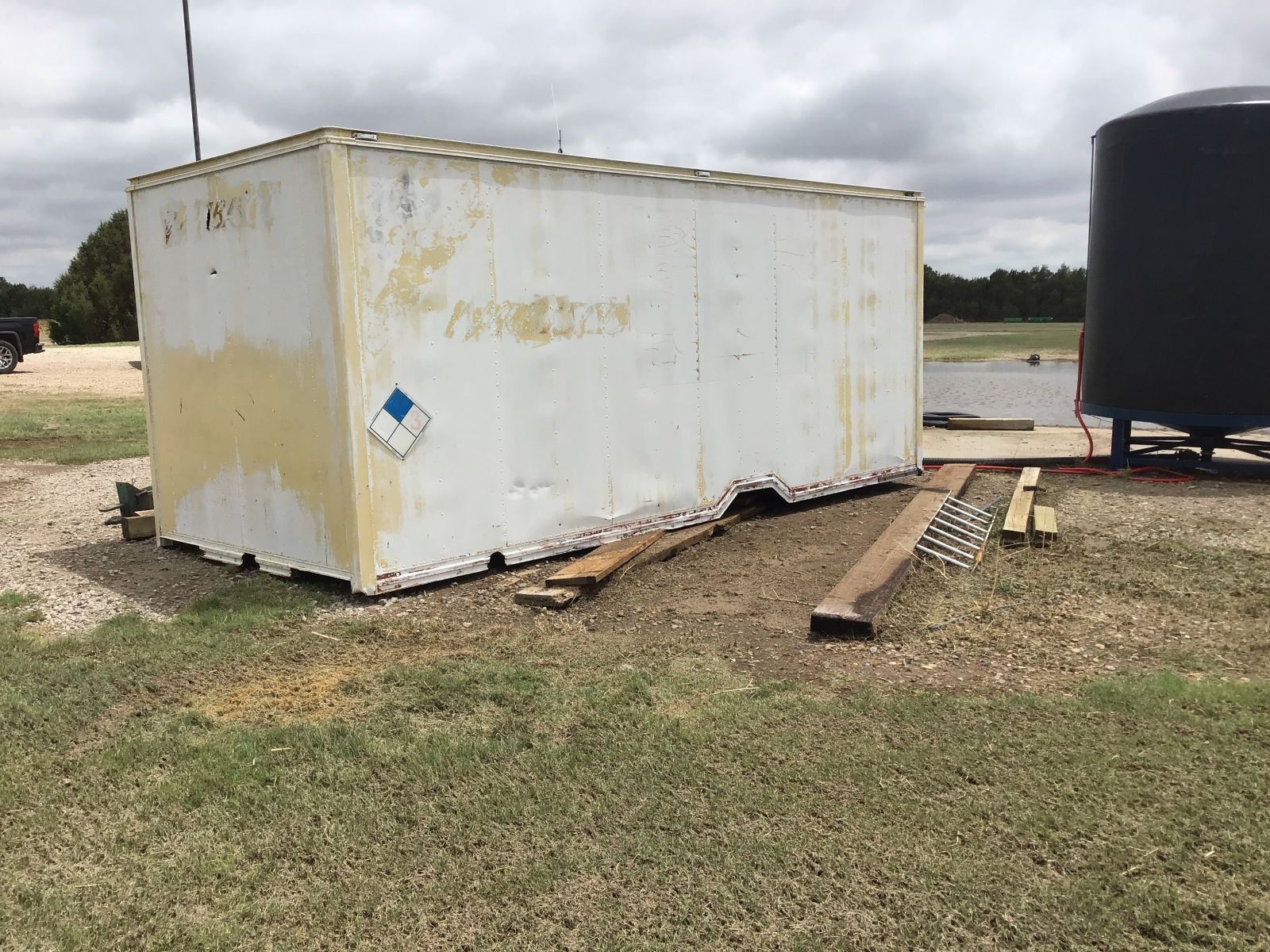
Storage container was pushed off the base by straight line winds. Source: NWS Damage Assessment |
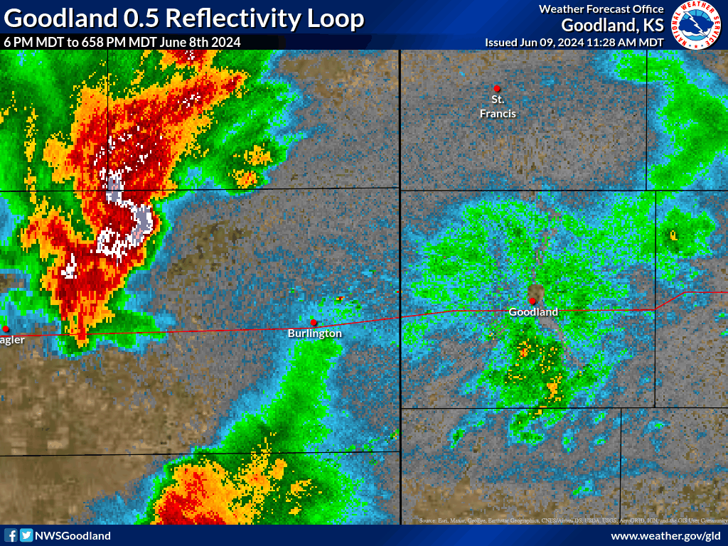
Radar
 |
 |
 |
 |
|
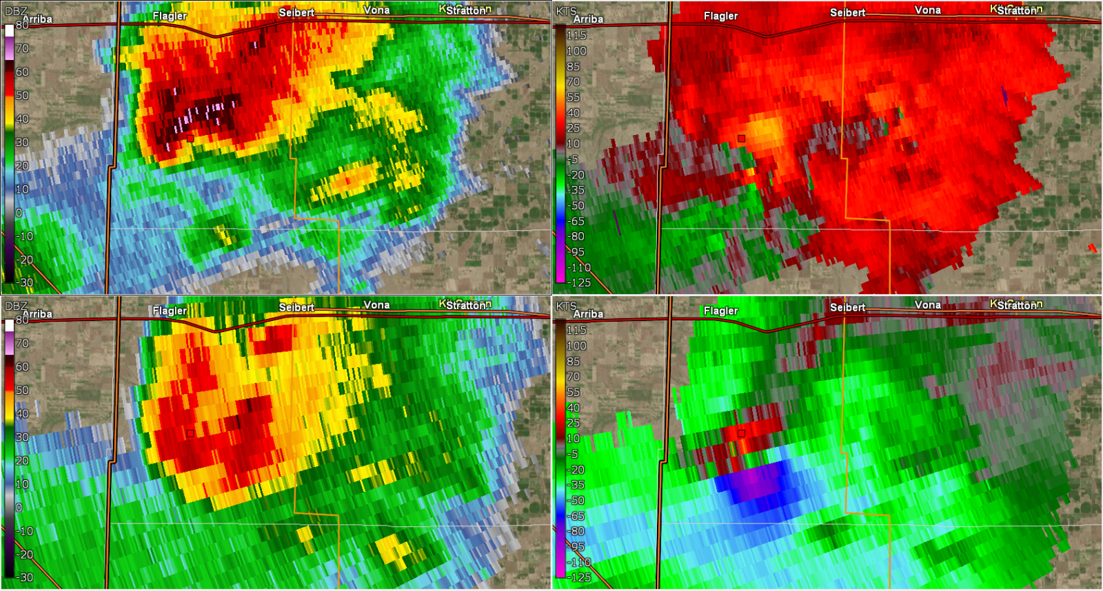
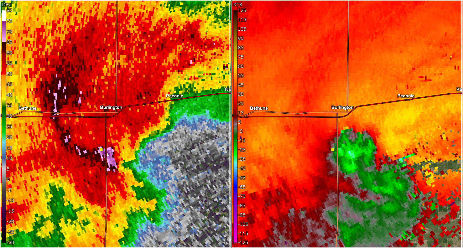
2237 UTC 0.5 Reflectivity/ 0.5 SRM/ 2.4 Reflectivity/ 2.4 SRM SRM means storm relative motion |
2249 UTC 0.5/0.9/2.4/3.1 Reflectivity Images show a "hole" in reflectivity aloft called a Bounded Weak Echo Region. This is associated with a strong rotating updraft. | 2249 UTC 0.5/0.9/2.4/3.1 Storm Relative Motion (SRM) . Red colors mean motion to the left of image, green/blue colors indicate motion to the right of image. Opposing colors next to each other indicate rotation. | 0052 UTC 0.5 Reflectivity and SRM around time Burlington airport measured 96 mph gust. |
 |
 |
||
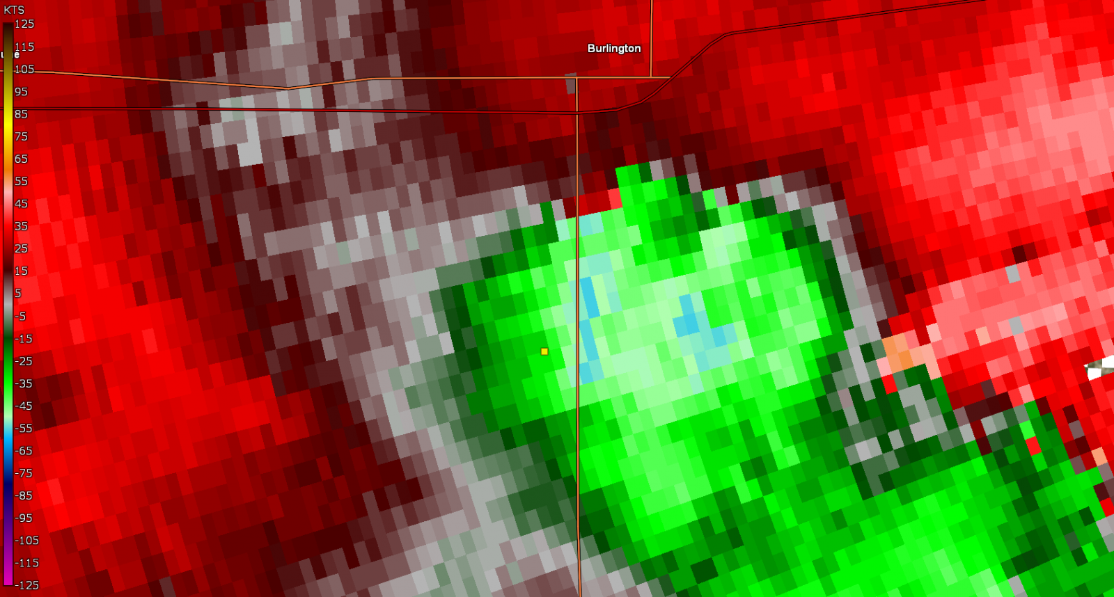
| 0052 Radial velocity around time of 96 mph wind gust. Velocities around 64 mph towards the radar. Knowing that the surface wind direction was 300 degrees we can estimate a true velocity of 98 mph. | Radar loop showing supercell moving over the Burlington area. |
Storm Reports
 |
Preliminary Local Storm Report...Summary
National Weather Service Goodland KS
1015 AM MDT Sun Jun 9 2024
..TIME... ...EVENT... ...CITY LOCATION... ...LAT.LON...
..DATE... ....MAG.... ..COUNTY LOCATION..ST.. ...SOURCE....
..REMARKS..
0710 PM Tstm Wnd Gst 16 S Kanorado 39.11N 102.02W
06/08/2024 E70 MPH Wallace KS Public
Public report of 70 MPH estimated winds and
pea sized hail.
0730 PM Hail 16 S Kanorado 39.11N 101.98W
06/08/2024 E0.75 Inch Wallace KS Public
Public report of 3/4 inch estimated hail.
0756 PM Tstm Wnd Gst Wallace 38.91N 101.59W
06/08/2024 E50 MPH Wallace KS CO-OP Observer
Estimated 40-50 MPH gusts.
0758 PM Tstm Wnd Gst Sharon Springs 38.90N 101.75W
06/08/2024 M65 MPH Wallace KS 911 Call Center
Dispatch reports 65 MPH gusts with the
storms.
0535 PM Hail 5 SSW Yuma 40.05N 102.76W
06/08/2024 E0.50 Inch Yuma CO Trained Spotter
Trained spotter reports 0.25-0.5 hail.
0410 PM Hail 2 W Flagler 39.29N 103.10W
06/08/2024 M0.88 Inch Kit Carson CO Public
Public report of up to nickel sized hail
starting to accumulate.
0425 PM Hail 8 S Flagler 39.18N 103.07W
06/08/2024 E2.75 Inch Kit Carson CO Public
Public report and photo via social media.
Hail size estimated from photo.
0426 PM Hail 4 S Flagler 39.24N 103.06W
06/08/2024 E1.25 Inch Kit Carson CO Public
Public report of hail a bit larger than
quarters abt 3.5 SSW of Flagler.
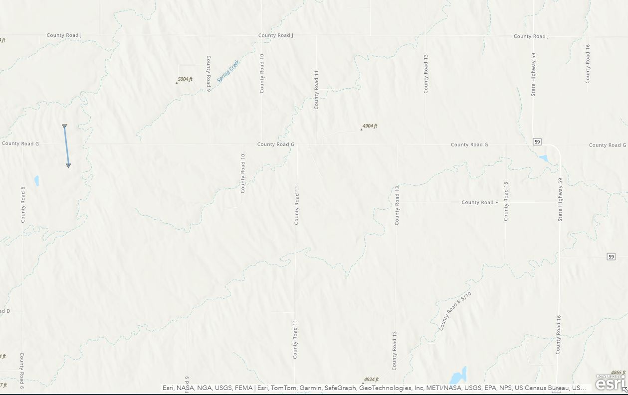
0439 PM Tornado 13 SSE Flagler 39.11N 103.01W
06/08/2024 Kit Carson CO Storm Chaser
Multiple chaser reports of a cone/multiple
vortices tornado near the vicinity of CR G
and 11. Tornado lasted 5-8 minutes.
0442 PM Hail 9 SSW Seibert 39.19N 102.93W
06/08/2024 E2.75 Inch Kit Carson CO Trained Spotter
Spotter report of baseball sized hail 3W of
hwy 52.
0447 PM Hail 7 S Flagler 39.19N 103.06W
06/08/2024 E2.00 Inch Kit Carson CO Storm Chaser
Delayed report. Chaser found hail roughly
size of an egg near the intersection of
County Road 5 and L.
0537 PM Tstm Wnd Gst 17 N Flagler 39.53N 103.02W
06/08/2024 M56 MPH Kit Carson CO Mesonet
Mesonet station EW7003 17 N Flagler.
0554 PM Tstm Wnd Gst 11 SW Joes 39.55N 102.85W
06/08/2024 E59 MPH Kit Carson CO Mesonet
KCOVONA2 reported a 59 MPH gust.
0625 PM Tstm Wnd Gst 7 N Stratton 39.41N 102.62W
06/08/2024 M77 MPH Kit Carson CO Mesonet
Ambient weather station SevenFarms.
0627 PM Tstm Wnd Gst 8 NNW Bethune 39.40N 102.50W
06/08/2024 M71 MPH Kit Carson CO Public
KCOSTRAT21.
0635 PM Tstm Wnd Gst 3 WSW Bethune 39.28N 102.48W
06/08/2024 M62 MPH Kit Carson CO Mesonet
Reported via KCOBETHU6.
0643 PM Tstm Wnd Gst 5 S Burlington 39.23N 102.28W
06/08/2024 M60 MPH Kit Carson CO ASOS
ASOS station KITR Burlington Co Airport.
0645 PM Tstm Wnd Gst 3 WSW Burlington 39.29N 102.32W
06/08/2024 M66 MPH Kit Carson CO Mesonet
Weather Link Station Road U.
0648 PM Tstm Wnd Gst 5 S Burlington 39.23N 102.28W
06/08/2024 M96 MPH Kit Carson CO ASOS
ASOS station KITR Burlington Co Airport.
0653 PM Tstm Wnd Gst 5 S Burlington 39.23N 102.28W
06/08/2024 M97 MPH Kit Carson CO ASOS
ASOS station KITR Burlington Co Airport.
0658 PM Tstm Wnd Gst 8 SSE Burlington 39.20N 102.20W
06/08/2024 M66 MPH Kit Carson CO Mesonet
Sustained at 47 mph.
0709 PM Tstm Wnd Gst 8 SSE Burlington 39.20N 102.22W
06/08/2024 E68 MPH Kit Carson CO Public
Weatherlink station Andrews Farms.
0719 PM Tstm Wnd Gst 12 S Peconic 39.15N 102.11W
06/08/2024 E100 MPH Kit Carson CO Trained Spotter
Trained spotter reports estimated 100 MPH
winds ongoing. House is trembling and lawn
furniture is moving. Pea sized hail too.
0817 PM Flash Flood 1 ESE Bethune 39.30N 102.41W
06/08/2024 Kit Carson CO Dept of Highways
DOT has closed US 24 between Burlington and
Stratton due to flooding.
0913 PM Flood 9 S Burlington 39.17N 102.28W
06/08/2024 Kit Carson CO Law Enforcement
County sheriff Facebook page shows water
flowing across Highway 385 south of the
airport.
0900 AM Flood 3 NW Burlington 39.33N 102.32W
06/09/2024 Kit Carson CO County Official
County road department reports roughly four
inches of water flowing over CR 46 where
Beaver Creek crosses the road.
0900 AM Flood 6 NE Bethune 39.37N 102.35W
06/09/2024 Kit Carson CO County Official
County road department reports roughly four
inches of water flowing over CR 44 where
Bonny Creek crosses the road.
0900 AM Flood 3 W Burlington 39.31N 102.33W
06/09/2024 Kit Carson CO County Official
County road department reports roughly four
inches of water flowing over CR 45, north of
Hwy 25 where Beaver Creek crosses the road.
0415 PM Hail 11 S Aroya 38.70N 103.16W
06/08/2024 E2.75 Inch Cheyenne CO Public
Public report and photo via social media.
0424 PM Tstm Wnd Dmg 17 NE Wild Horse 39.01N 102.80W
06/08/2024 Cheyenne CO Storm Chaser
spotter network report of one power pole
snapped and down on east side of highway...
time estimated from radar.
0531 PM Hail 15 N Kit Carson 38.97N 102.80W
06/08/2024 E1.50 Inch Cheyenne CO Storm Chaser
Corrects previous hail report from 15 N Kit
Carson. Hail up to 1 inch from spotters live
feed.
0545 PM Hail 9 N Kit Carson 38.89N 102.80W
06/08/2024 E2.00 Inch Cheyenne CO Public
Public report and photo via social media.
Hail size estimated from photo.
0600 PM Hail 5 ESE Kit Carson 38.74N 102.71W
06/08/2024 E2.00 Inch Cheyenne CO Public
Public report and photo via social media.
Hail size estimated from photo.
0613 PM Hail 4 ENE Kit Carson 38.78N 102.72W
06/08/2024 E2.00 Inch Cheyenne CO Trained Spotter
Spotter provided pictures showing several
large hail stones approximately two inches
in diameter. Photos provided via Facebook.
0622 PM Hail 4 W Firstview 38.80N 102.61W
06/08/2024 M0.75 Inch Cheyenne CO Public
Report from mPING: Dime (0.75 in.).
0623 PM Hail 4 W Firstview 38.80N 102.61W
06/08/2024 E1.00 Inch Cheyenne CO Public
Report from mPING: Quarter (1.00 in.).
0659 PM Tstm Wnd Gst Aroya 38.85N 103.13W
06/08/2024 M66 MPH Cheyenne CO Mesonet
Mesonet station UP695 Aroya (UPR).
0707 PM Tstm Wnd Gst Wild Horse 38.83N 103.00W
06/08/2024 M82 MPH Cheyenne CO Trained Spotter
Trained spotter with anemometer measured an
82 MPH gust at Wild Horse due to outflow.
0714 PM Tstm Wnd Gst 5 NNW Arapahoe 38.92N 102.20W
06/08/2024 M58 MPH Cheyenne CO Mesonet
KCOARAPA3 reports 58 MPH gust.
0714 PM Tstm Wnd Gst 2 SW Firstview 38.80N 102.55W
06/08/2024 M58 MPH Cheyenne CO Mesonet
KCOCHEYE8 reports of a gust of 58 MPH.
0717 PM Tstm Wnd Gst Firstview 38.82N 102.54W
06/08/2024 M62 MPH Cheyenne CO Mesonet
Mesonet station CO068 040w460 U40-Firstview.
0721 PM Hail Wild Horse 38.82N 103.00W
06/08/2024 E1.25 Inch Cheyenne CO Storm Chaser
spotter network report.
0738 PM Tstm Wnd Gst 3 WSW Firstview 38.81N 102.59W
06/08/2024 E60 MPH Cheyenne CO Mesonet
U40 Firstview.
0758 PM Tstm Wnd Gst Firstview 38.82N 102.54W
06/08/2024 M53 MPH Cheyenne CO Mesonet
Mesonet station CO068 040w460 U40-Firstview.
&&
$$
 |
Media use of NWS Web News Stories is encouraged! Please acknowledge the NWS as the source of any news information accessed from this site. |
|