Overview
A significant severe weather event occurred across the Tri-State Region on the evening of August 11th, 2019. Widespread damaging winds, heavy rainfall, and flash flooding was reported to NWS Goodland. In addition, a few tornadoes occurred along with some large hail. This page provides a summary of those reports received from emergency management, first responders, trained spotters, local media, and the general public. We thank you for all of the information.
The event began with a couple supercell thunderstorms over Yuma County Colorado and Cheyenne County Kansas. These are the primary storms that produced the large hail and tornadoes. The event evolved with several lines of storms forming, including a large line of storms that moved across Cheyenne, Rawlins, Decatur, Norton, Sherman, Thomas, Sheridan, and Graham counties in northwest Kansas. A second line of storms produced wind damage in Cheyenne County Colorado. These storms later produced heavy rain across Wallace, Logan, and Gove counties in Northwest Kansas.
Tornadoes:
|
|
||||||||||
|
||||||||||
|
Tornado - 6 SE Wheeler, KS
Track Map 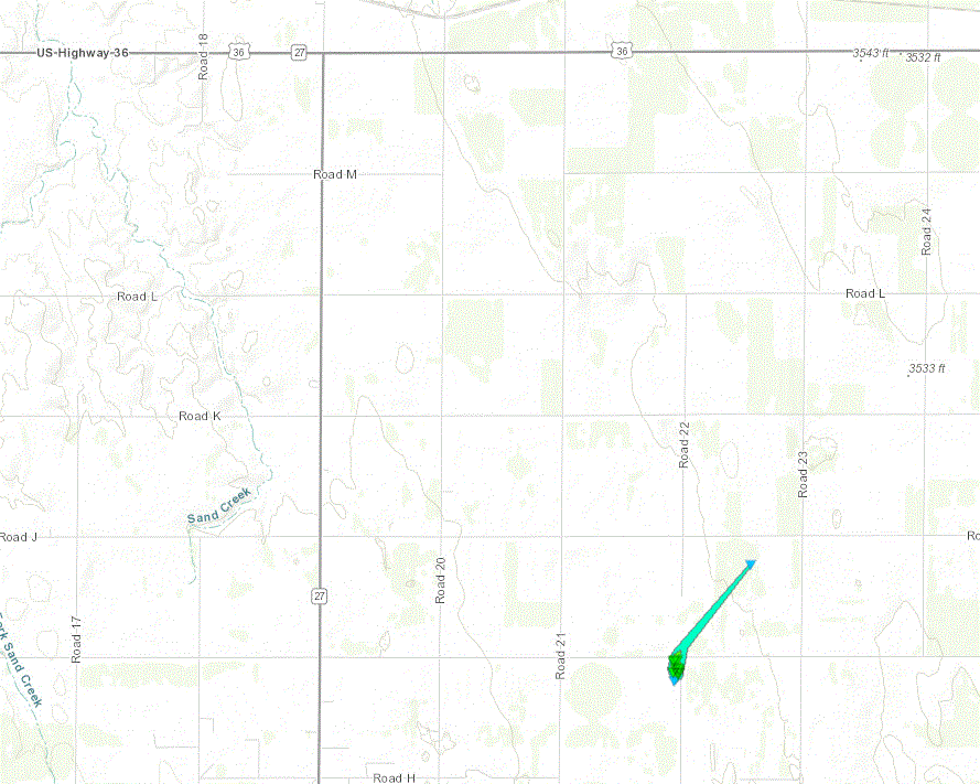  |
||||||||||||||||
|
Tornado - 7 WSW Wauneta, CO
Track Map  |
||||||||||||||||
The Enhanced Fujita (EF) Scale classifies tornadoes into the following categories:
| EF0 Weak 65-85 mph |
EF1 Moderate 86-110 mph |
EF2 Significant 111-135 mph |
EF3 Severe 136-165 mph |
EF4 Extreme 166-200 mph |
EF5 Catastrophic 200+ mph |
 |
|||||
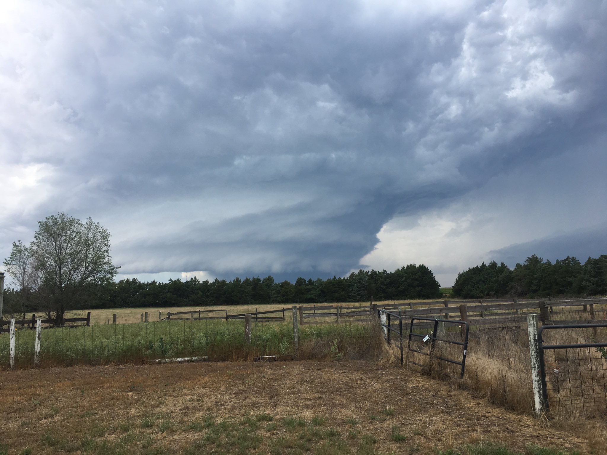
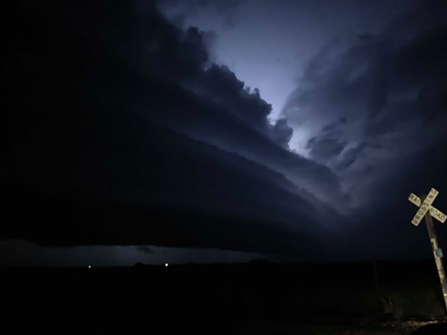
Photos & Video
Here are some of the photos received from this severe weather event. Thank you to all the submissions received!
 |
 |
 |
 |
| Storm structure northeast of Yuma, CO (Jody Brander) |
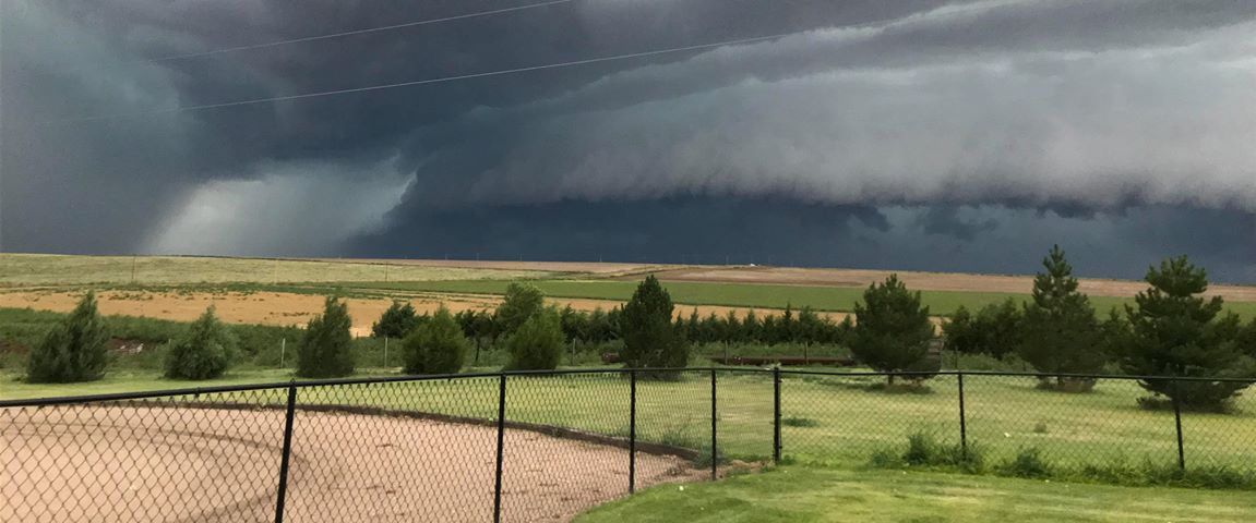
Storm structure near Almena, KS (Briana Denise Fuemmler) |
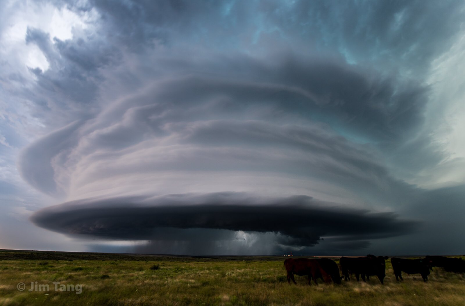
Storm structure near McDonald (Jim Tang) |
Storm structure near St. Francis (Samantha Raile) |
 |
 |
 |
 |
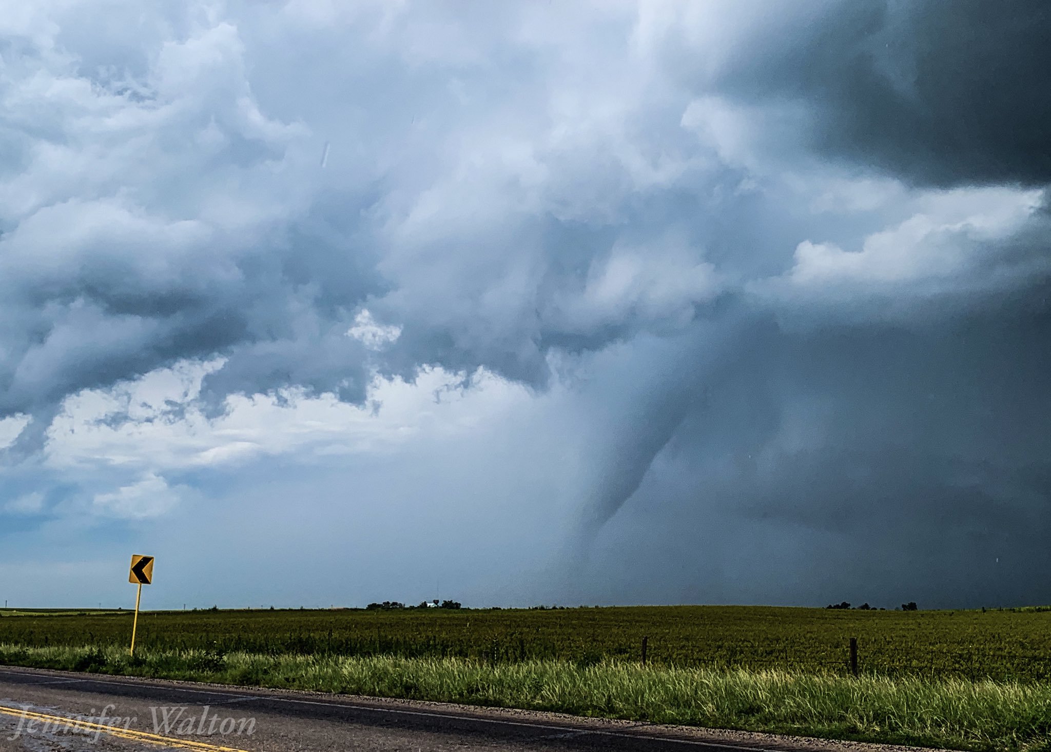
| Tornado northwest of Yuma, CO (Jen Walton) |
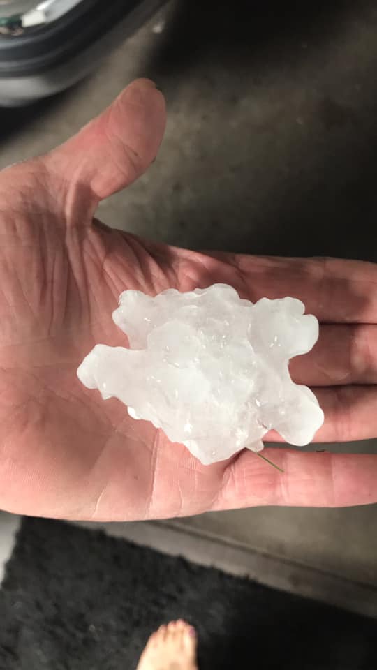
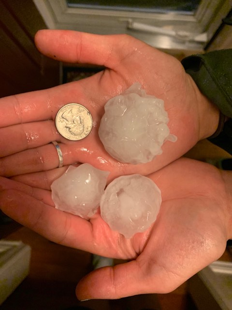
Hail in Bird City, KS (Carrie Renee Magnani) |
Bird City, KS hail (Teryn Carmichael) |
Hail in Bird City. KS (Jill Paugh) |
 |
 |
 |
 |
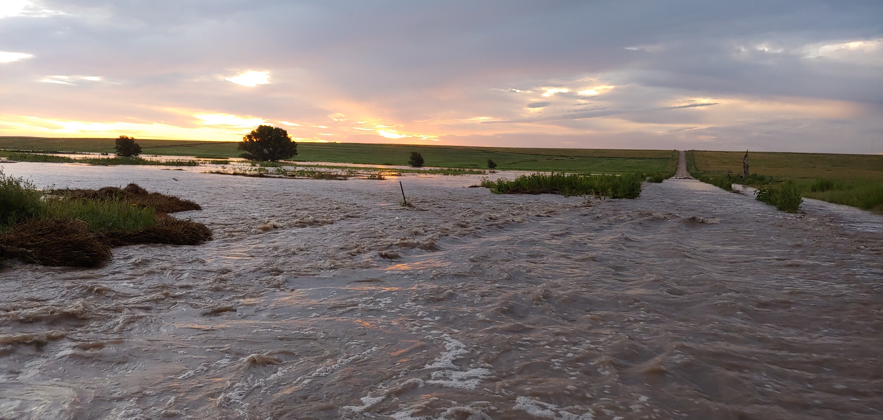
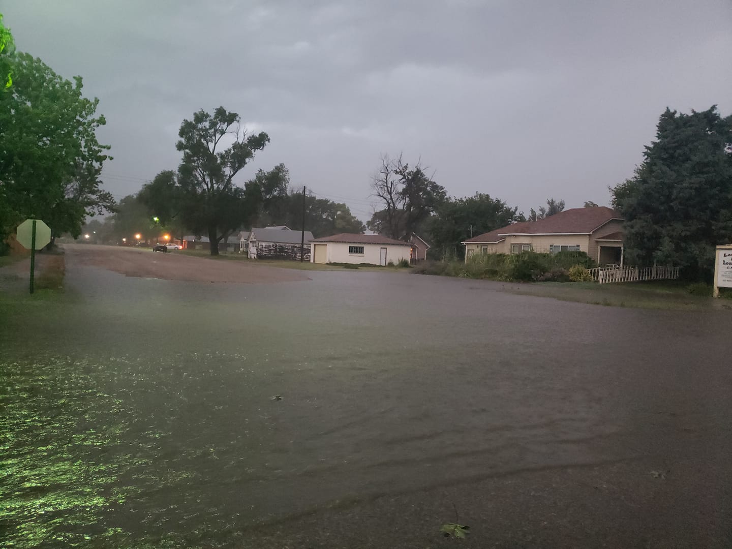
| Creek flooding northeast of Goodland (Craig Crouch) |
Bird City, KS flooding (Jill Paugh) |
Colby wind damage (Zenaeh Siefers) |
Wind damage in Atwood, KS (Andrew Kay Melia) |
 |
 |
 |
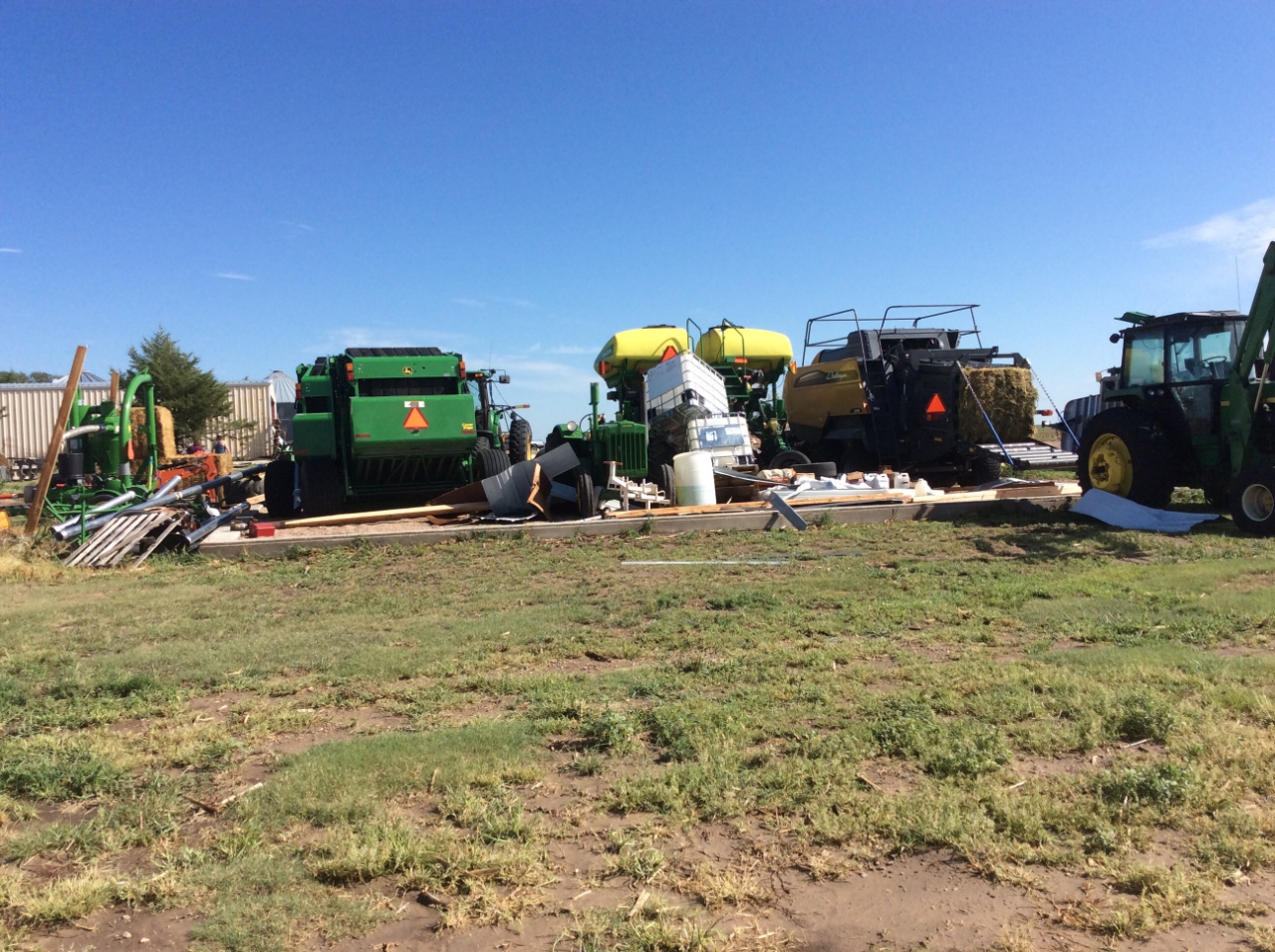 |
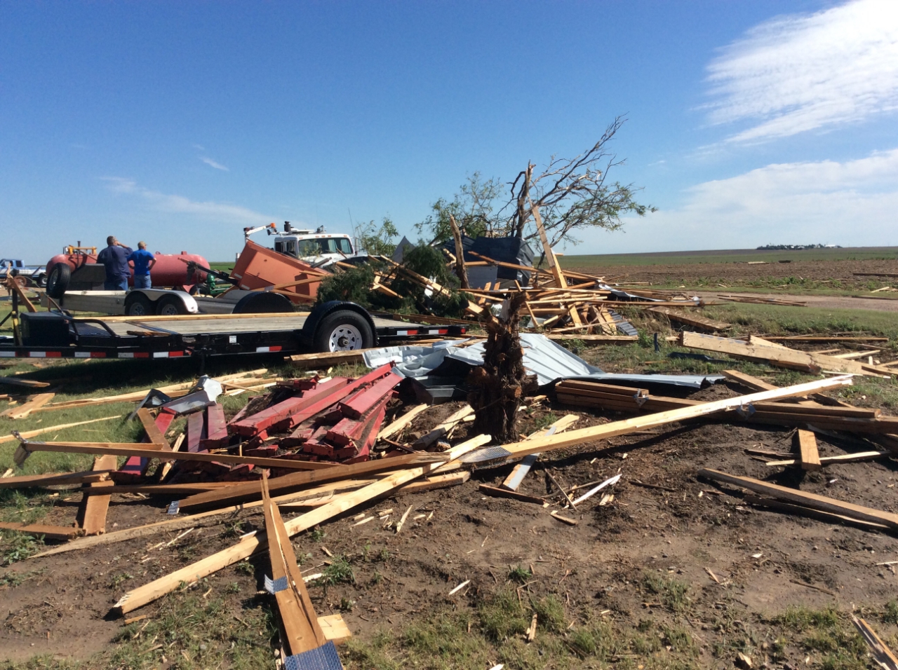
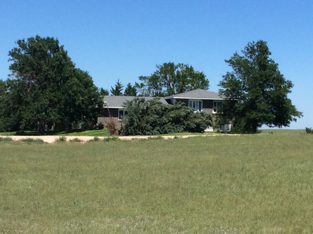
| Snapped tree south of Wheeler (NWS Storm Survey) |
Missing grain bin south of Wheeler (NWS Storm Survey) |
Uprooted tree south of Wheeler (NWS Storm Survey) |
Destroyed outbuilding south of Wheeler (NWS Storm Survey) |
 |
 |
 |
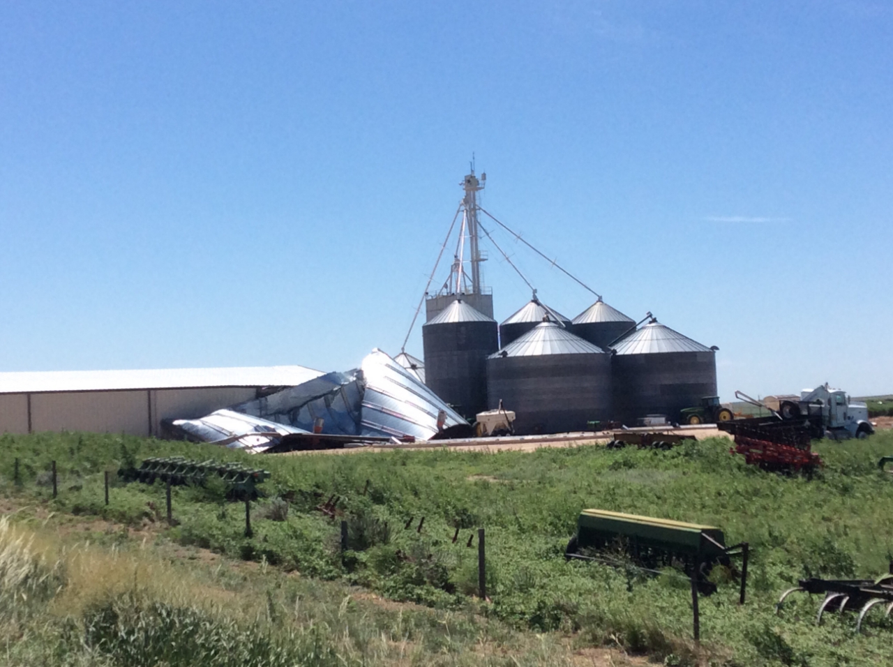 |
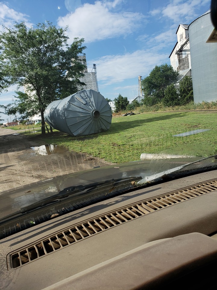
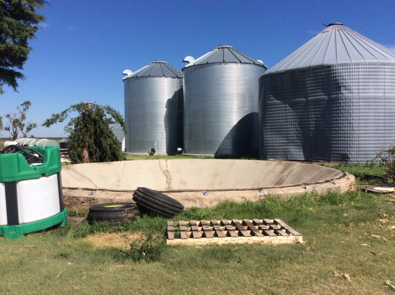
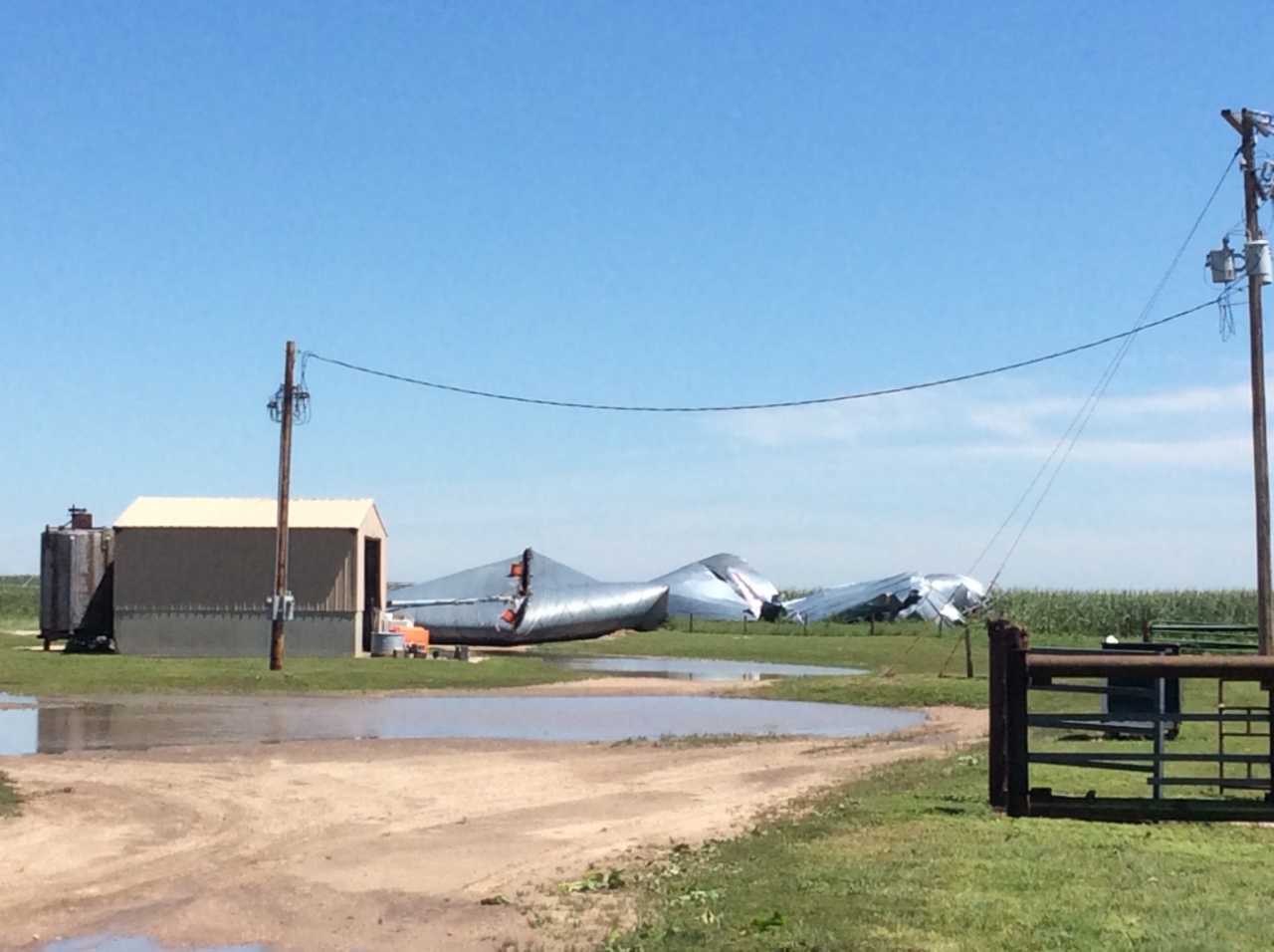
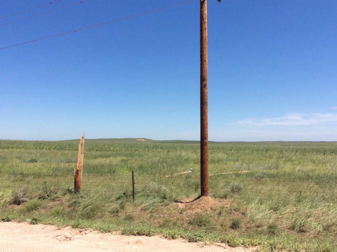
| Destroyed grain bins 7 north of Wray (NWS Storm Survey) |
Snapped power pole north of Wray (NWS Storm Survey) |
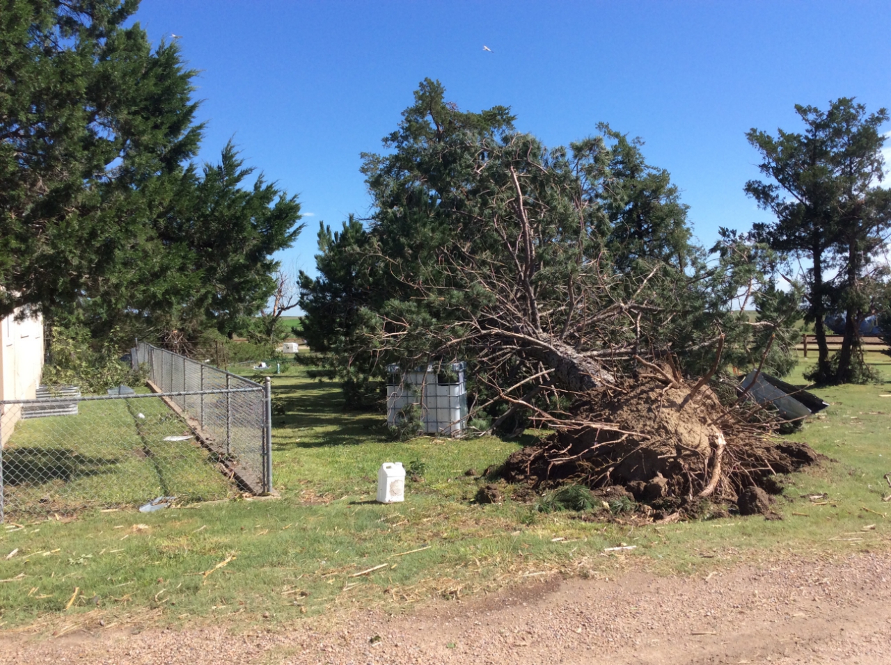
Uprooted tree north of Wray (NWS Storm Survey) |
Grain bin damage north of Wray (NWS Storm Survey) |
Radar
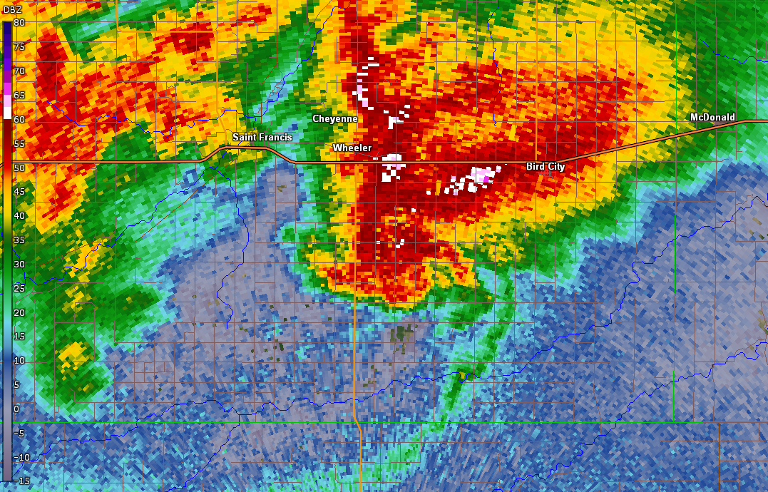
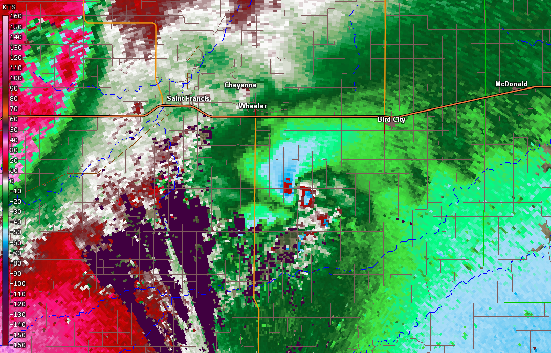
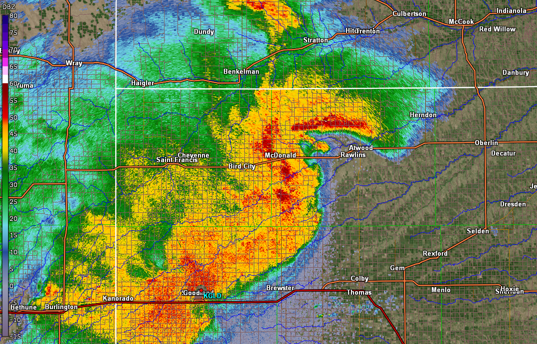
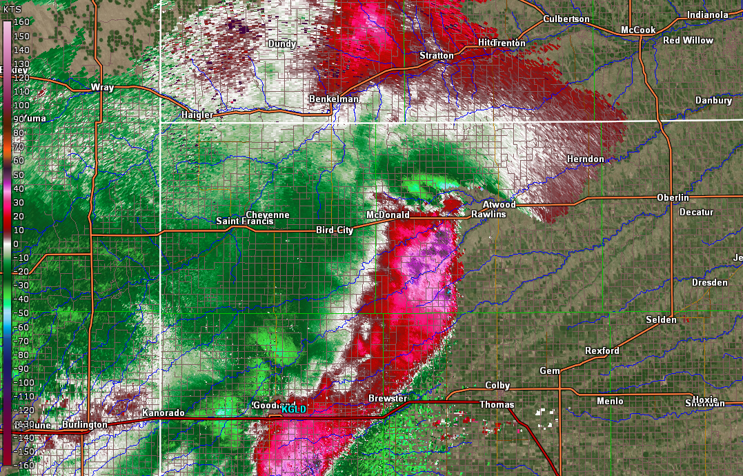
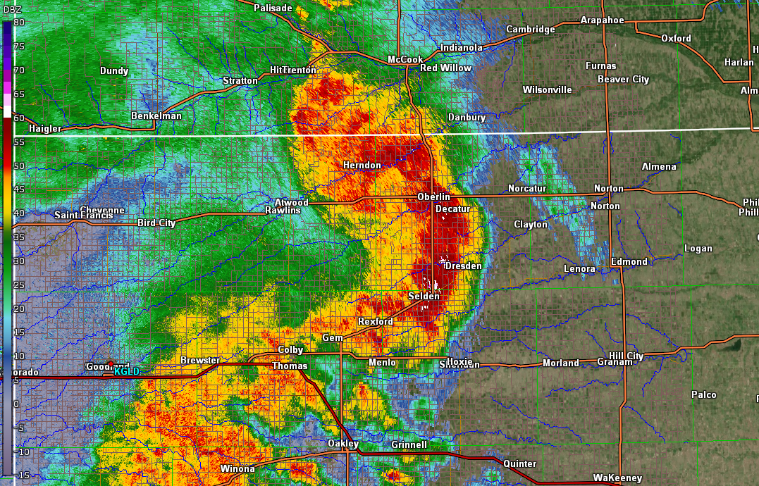
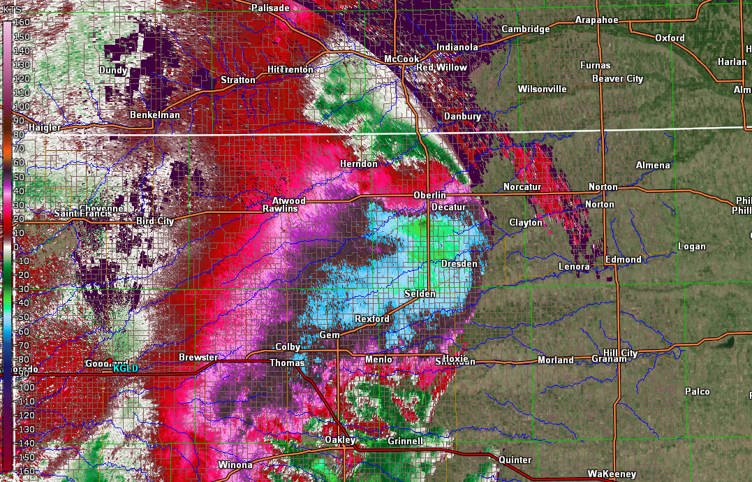
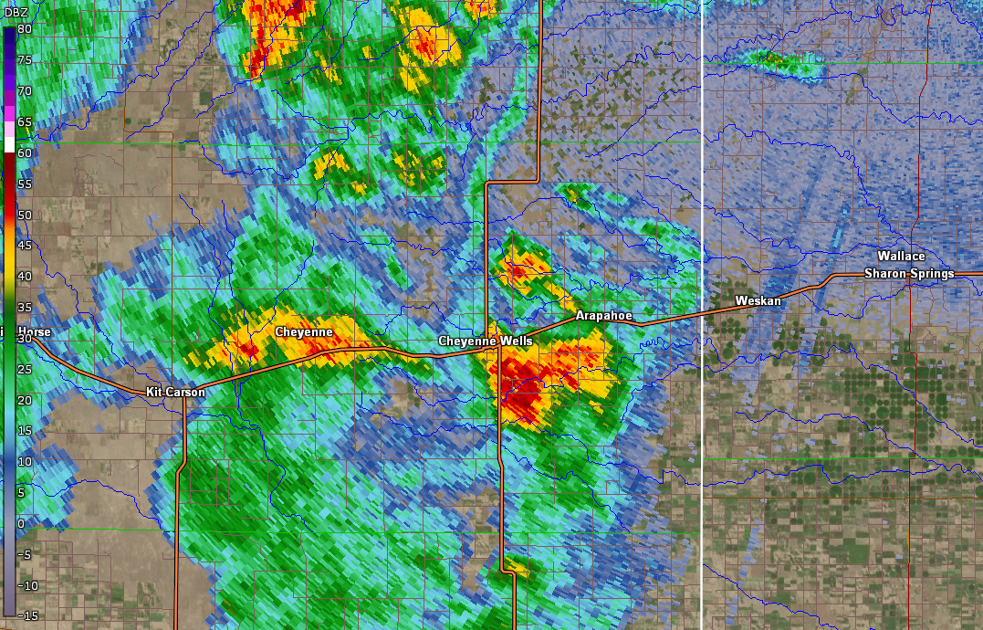
Here are some of the more interesting radar features observed with this event.
 |
 |
 |
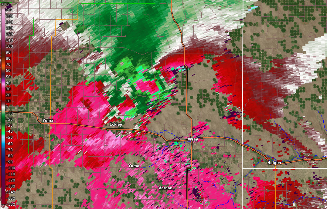 |
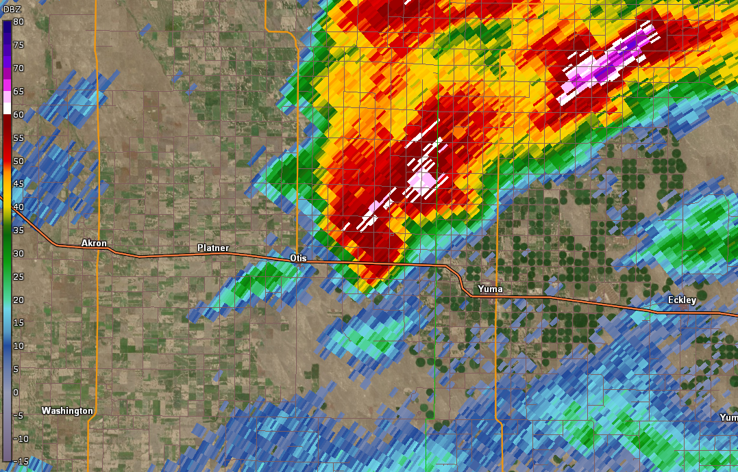
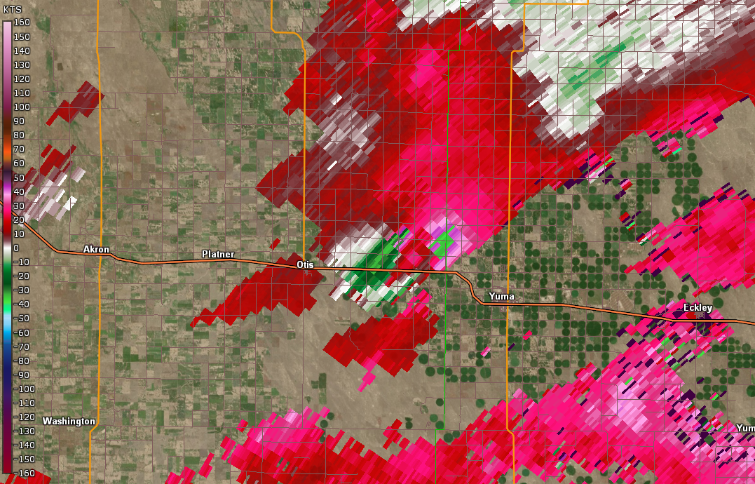
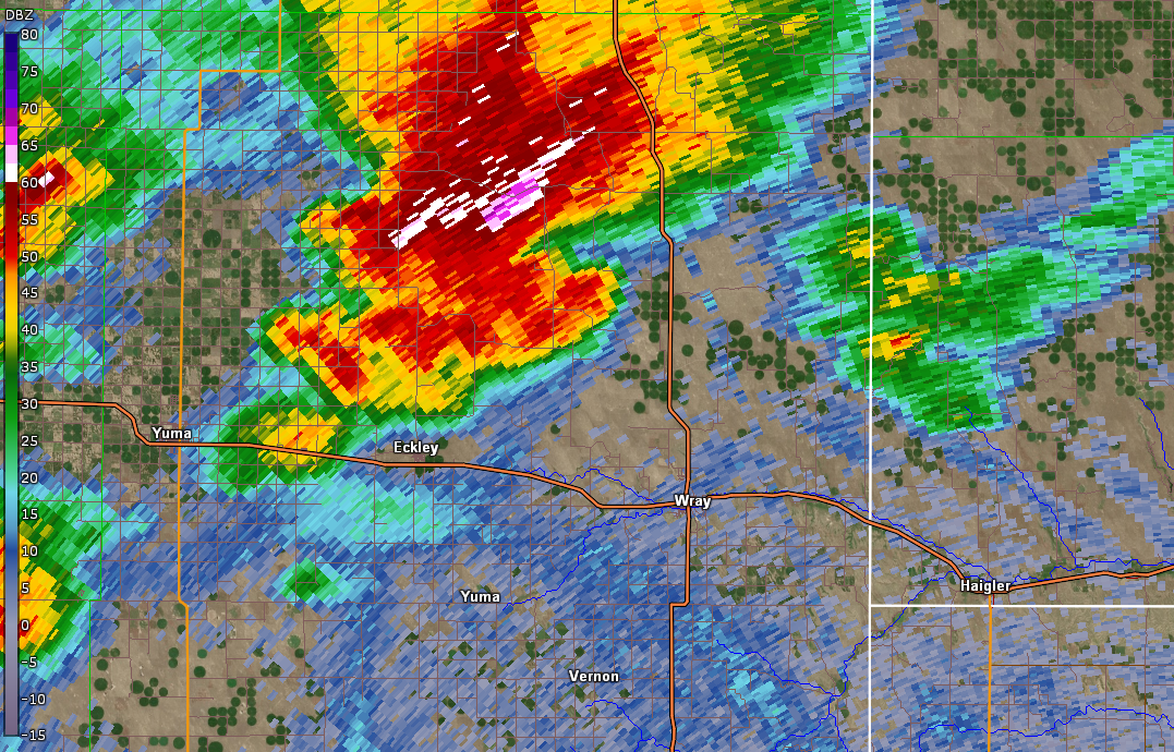
| Tornadic Storm along Yuma and Washington County Border (Reflectivity, 4:15 pm MDT) | Tornadic Storm along Yuma and Washington County Border (Storm Relative Velocity, 4:15 pm MDT) | Tornadic Storm northeast of Wray, CO (Reflectivity, 5:06 pm MDT) | Tornadic Storm northeast of Wray, CO (Storm Relative Velocity, 5:06 pm MDT) |
 |
 |
 |
 |
| Tornadic Storm southeast of Wheeler, KS (Reflectivity, 7:48 pm CDT) | Tornadic Storm southeast of Wheeler, KS (Storm Relative Velocity, 7:48 pm CDT) | Supercell thunderstorm beginning to merge with developing bow echo over Rawlins County, KS (Reflectivity, 8:58 pm CDT) | Supercell thunderstorm beginning to merge with developing bow echo over Rawlins County, KS (Velocity, 8:58 pm CDT) |
 |
 |
 |
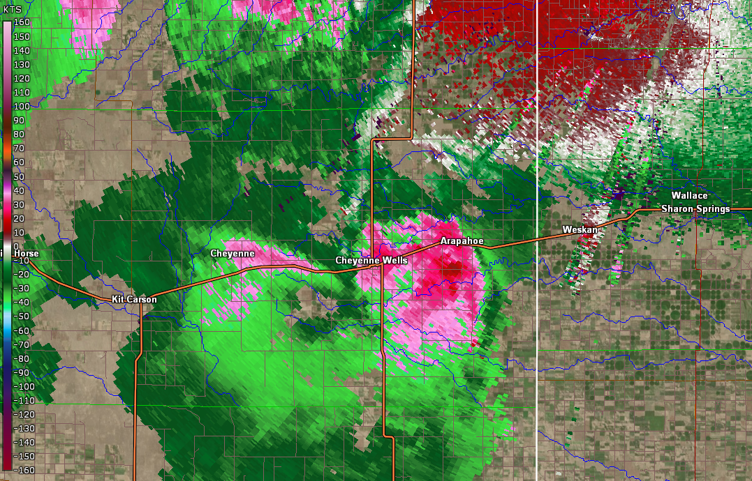 |
| Mature bow echo moving across Decatur County, KS (Reflectivity, 10:02 pm CDT) | Mature bow echo moving across Decatur County, KS (Velocity, 10:02 pm CDT) | Damaging downburst winds in Arapahoe, CO (Reflectivity, 6:12 pm MDT) | Damaging downburst winds in Arapahoe, CO (Velocity, 6:12 pm MDT) |
 |
 |
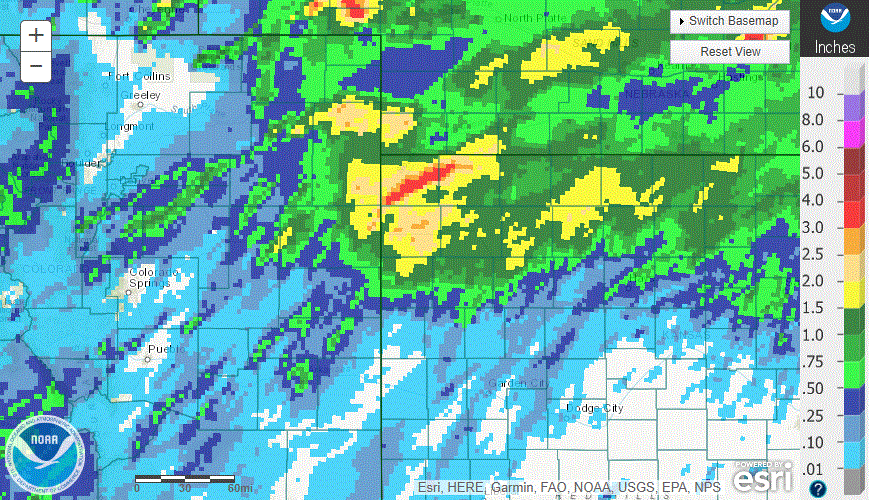 |
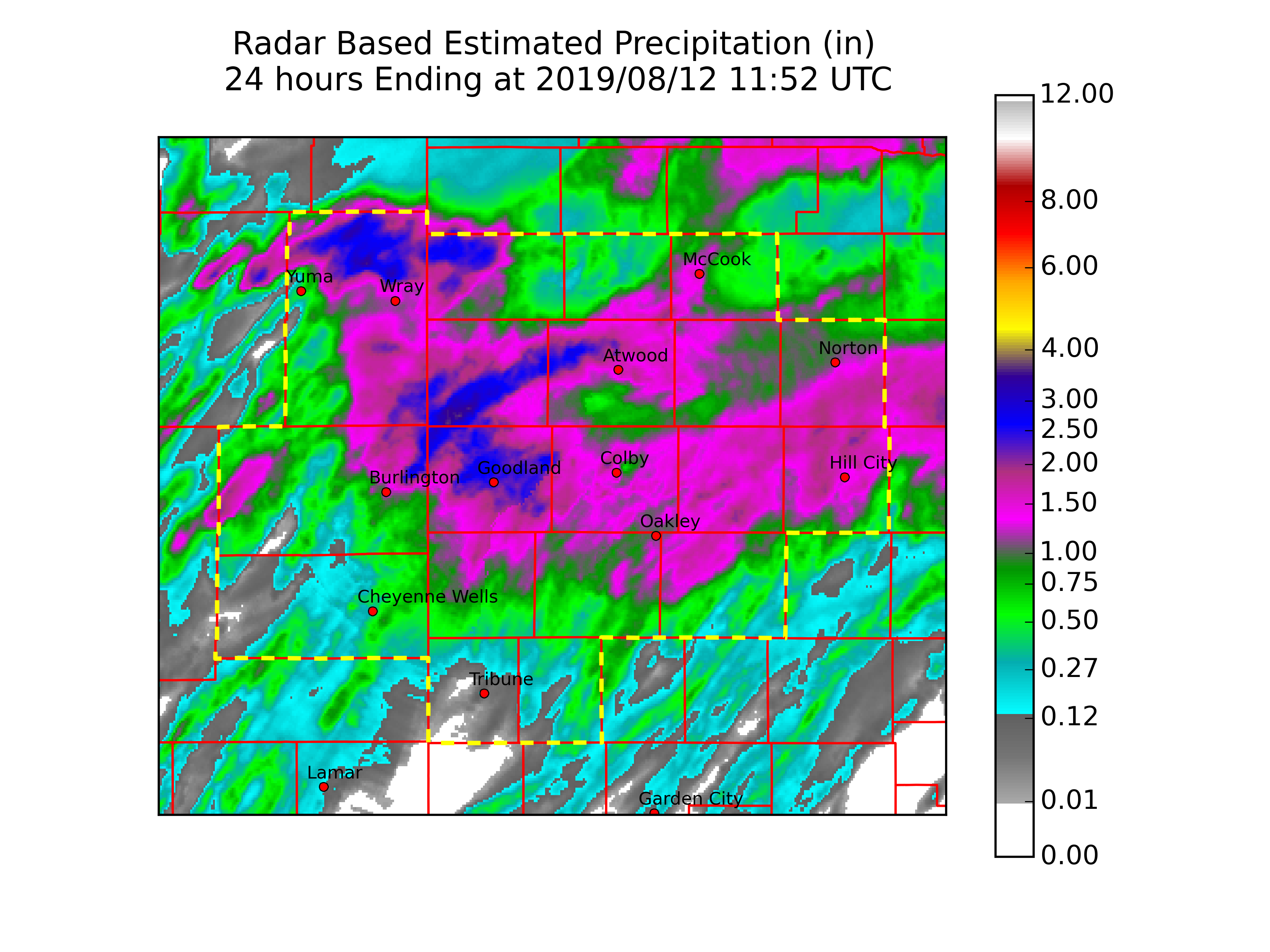
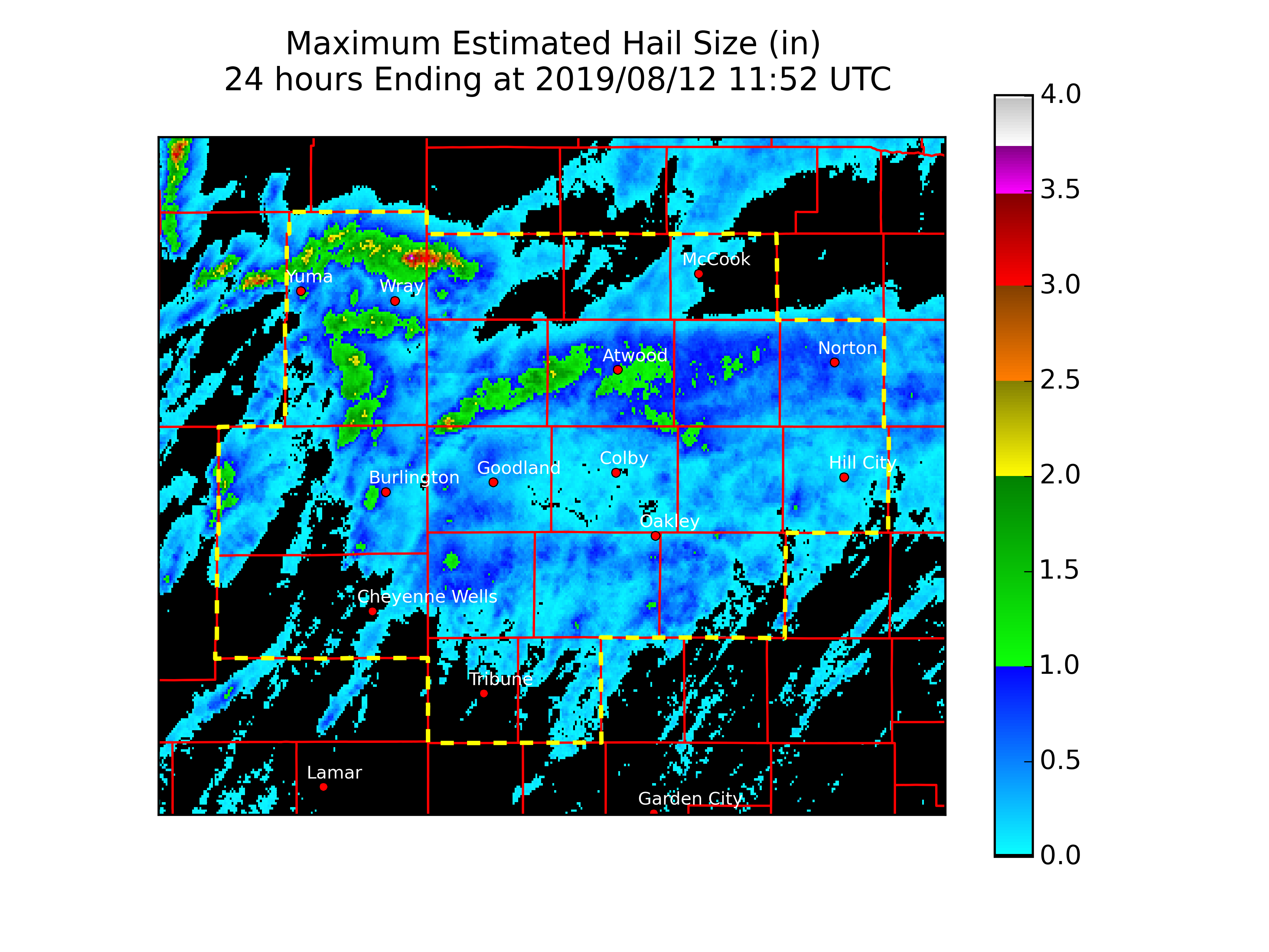
| NWS Goodland Forecast Area Rainfall | NWS Goodland Forecast Area Radar Estimated Hail Tracks | Regional Radar. Note the swaths of rain associated with supercells over SW Kansas and NW Kansas to central Nebraska |
Storm Reports
PRELIMINARY LOCAL STORM REPORT...SUMMARY
NATIONAL WEATHER SERVICE GOODLAND KS
152 PM MDT MON AUG 12 2019
..TIME... ...EVENT... ...CITY LOCATION... ...LAT.LON...
..DATE... ....MAG.... ..COUNTY LOCATION..ST.. ...SOURCE....
..REMARKS..
0933 AM FLASH FLOOD 7 W MONUMENT 39.09N 101.12W
08/12/2019 LOGAN KS EMERGENCY MNGR
CORRECTS PREVIOUS FLASH FLOOD REPORT FROM 7
W MONUMENT. PORTIONS OF COUNTY ROADS 290/300
SOUTH OF HIGHWAY 40 REMAIN FLOODED.
0930 AM HEAVY RAIN 3 SW GOODLAND 39.32N 101.75W
08/12/2019 M2.25 INCH SHERMAN KS PUBLIC
PUBLIC REPORTED VIA FACEBOOK COMMENT 2.25
INCHES OF STORM TOTAL PRECIPITATION FROM
STORMS YESTERDAY EVENING.
0924 AM HEAVY RAIN 7 N KANORADO 39.44N 102.04W
08/12/2019 E2.50 INCH SHERMAN KS PUBLIC
PUBLIC REPORTED VIA FACEBOOK COMMENT 2.5
INCHES OF STORM TOTAL PRECIPITATION FOR
STORMS YESTERDAY EVENING. REPORT ALSO
INCLUDED WINDS 60 TO 70 MPH LAST NIGHT.
0922 AM HEAVY RAIN 7 S WAUNETA 40.19N 102.23W
08/12/2019 E4.50 INCH YUMA CO PUBLIC
PUBLIC REPORTED VIA FACEBOOK COMMENT 4.5
INCHES OF STORM TOTAL PRECIPITATION FROM
STORMS YESTERDAY EVENING.
0902 AM HEAVY RAIN MCCOOK 40.20N 100.62W
08/12/2019 M1.33 INCH RED WILLOW NE PUBLIC
PUBLIC REPORTED VIA FACEBOOK COMMENT 1.33
INCHES OF STORM TOTAL PRECIPITATION FROM
STORMS YESTERDAY EVENING.
0858 AM HEAVY RAIN 4 ENE RULETON 39.36N 101.80W
08/12/2019 M1.65 INCH SHERMAN KS PUBLIC
PUBLIC REPORTED VIA FACEBOOK COMMENT 1.65
INCHES OF STORM TOTAL PRECIPITATION FROM
STORMS YESTERDAY EVENING.
0857 AM HEAVY RAIN GRAINFIELD 39.11N 100.47W
08/12/2019 M2.25 INCH GOVE KS PUBLIC
PUBLIC REPORTED VIA FACEBOOK COMMENT 2.25
INCHES OF STORM TOTAL PRECIPITATION FROM
STORMS YESTERDAY EVENING.
0857 AM HEAVY RAIN 1 NW BEECHER ISLAND 39.89N 102.15W
08/12/2019 E2.00 INCH YUMA CO PUBLIC
PUBLIC REPORTED VIA FACEBOOK COMMENT 2
INCHES OF STORM TOTAL PRECIPITATION FROM
STORMS YESTERDAY EVENING.
0855 AM HEAVY RAIN 1 NNW GOODLAND 39.36N 101.71W
08/12/2019 M3.80 INCH SHERMAN KS PUBLIC
PUBLIC REPORTED VIA FACEBOOK COMMENT 3.80
INCHES OF STORM TOTAL PRECIPITATION FROM
STORMS YESTERDAY EVENING.
0854 AM HEAVY RAIN 5 SE RULETON 39.29N 101.82W
08/12/2019 E3.00 INCH SHERMAN KS PUBLIC
PUBLIC REPORTED VIA FACEBOOK COMMENT 3
INCHES OF STORM TOTAL PRECIPITATION FROM
STORMS YESTERDAY EVENING.
0853 AM HEAVY RAIN MONUMENT 39.10N 101.00W
08/12/2019 E2.00 INCH LOGAN KS PUBLIC
PUBLIC REPORTED VIA FACEBOOK COMMENT 2
INCHES OF STORM TOTAL PRECIPITATION FROM
STORMS YESTERDAY EVENING.
0852 AM HEAVY RAIN 3 WSW TRAER 39.91N 100.70W
08/12/2019 M1.77 INCH DECATUR KS PUBLIC
PUBLIC REPORTED VIA FACEBOOK COMMENT 1.77
INCHES OF STORM TOTAL PRECIPITATION FROM
STORMS YESTERDAY EVENING.
0851 AM HEAVY RAIN REXFORD 39.47N 100.74W
08/12/2019 M2.64 INCH THOMAS KS PUBLIC
PUBLIC REPORTED VIA FACEBOOK COMMENT 2.64
INCHES OF STORM TOTAL PRECIPITATION FROM
STORMS YESTERDAY EVENING.
0850 AM HEAVY RAIN 1 W GOODLAND 39.35N 101.72W
08/12/2019 M3.00 INCH SHERMAN KS PUBLIC
PUBLIC REPORTED VIA FACEBOOK COMMENT 3.0
INCHES OF STORM TOTAL PRECIPITATION FROM
STORMS YESTERDAY EVENING. REPORT INCLUDED A
PICTURE OF A RAIN GAUGE.
0849 AM HEAVY RAIN 9 SSE BEECHER ISLAND 39.76N 102.05W
08/12/2019 M2.30 INCH YUMA CO PUBLIC
PUBLIC REPORTED VIA FACEBOOK COMMENT 2.30
INCHES OF STORM TOTAL PRECIPITATION FROM
STORMS YESTERDAY EVENING.
0655 AM HEAVY RAIN 2 NNW BLAKEMAN 39.84N 101.13W
08/12/2019 M2.50 INCH RAWLINS KS TRAINED SPOTTER
TOTAL RAINFALL OVER PREVIOUS 12 HOURS.
0646 AM HEAVY RAIN 7 N COLBY 39.48N 101.05W
08/12/2019 M1.60 INCH THOMAS KS PUBLIC
VIA FACEBOOK. TOTAL RAINFALL OVER PREVIOUS
12 HOURS.
0645 AM HEAVY RAIN 2 W GOODLAND 39.35N 101.75W
08/12/2019 M2.80 INCH SHERMAN KS PUBLIC
VIA FACEBOOK. TOTAL RAINFALL OVER THE
PREVIOUS 12 HOURS.
0634 AM HEAVY RAIN COLBY 39.39N 101.05W
08/12/2019 M1.44 INCH THOMAS KS TRAINED SPOTTER
VIA FACEBOOK. TOTAL RAINFALL OVER PREVIOUS
12 HOURS.
0624 AM HEAVY RAIN GOODLAND 39.35N 101.71W
08/12/2019 M2.25 INCH SHERMAN KS PUBLIC
VIA FACEBOOK. TOTAL RAINFALL OVER PREVIOUS
12 HOURS.
0605 AM FLOOD 2 WSW GOODLAND 39.34N 101.74W
08/12/2019 SHERMAN KS PUBLIC
VIA FACEBOOK. COUNTY ROAD COMPLETELY
IMMERSED UNDER WATER.
0602 AM HEAVY RAIN 10 N TASCO 39.49N 100.27W
08/12/2019 M1.83 INCH SHERIDAN KS PUBLIC
VIA FACEBOOK. TOTAL RAINFALL OVER PREVIOUS
12 HOURS.
0558 AM HEAVY RAIN 11 S BEARDSLEY 39.65N 101.23W
08/12/2019 M1.40 INCH RAWLINS KS PUBLIC
VIA FACEBOOK. TOTAL RAINFALL OVER PREVIOUS
12 HOURS.
0553 AM HEAVY RAIN 5 S EDSON 39.26N 101.54W
08/12/2019 M2.75 INCH SHERMAN KS PUBLIC
VIA FACEBOOK. TOTAL RAINFALL OVER PREVIOUS
12 HOURS.
0553 AM HEAVY RAIN 5 N GOODLAND 39.42N 101.71W
08/12/2019 M3.80 INCH SHERMAN KS PUBLIC
VIA FACEBOOK. TOTAL RAINFALL OVER PREVIOUS
12 HOURS.
0545 AM HEAVY RAIN 15 SE GOVE 38.81N 100.29W
08/12/2019 M1.01 INCH GOVE KS PUBLIC
VIA FACEBOOK. TOTAL RAINFALL OVER PREVIOUS
48 HOURS. 0.11 INCHES OF RAINFALL IN
PREVIOUS 24 HOURS.
0542 AM HEAVY RAIN 5 NW BIRD CITY 39.80N 101.60W
08/12/2019 M3.10 INCH CHEYENNE KS PUBLIC
VIA FACEBOOK. TOTAL RAINFALL OVER PREVIOUS
12 HOURS.
0536 AM HEAVY RAIN 11 NNE GOODLAND 39.50N 101.63W
08/12/2019 M2.52 INCH SHERMAN KS PUBLIC
VIA FACEBOOK. TOTAL RAINFALL OVER PREVIOUS
12 HOURS.
0531 AM HEAVY RAIN GOODLAND 39.35N 101.70W
08/12/2019 M3.12 INCH SHERMAN KS PUBLIC
VIA FACEBOOK. TOTAL RAINFALL OVER PREVIOUS
12 HOURS.
0519 AM HEAVY RAIN OAKLEY 39.13N 100.86W
08/12/2019 M1.38 INCH LOGAN KS EMERGENCY MNGR
TOTAL RAINFALL OVER PREVIOUS 12 HOURS.
0516 AM HEAVY RAIN MCCOOK 40.20N 100.63W
08/12/2019 M1.68 INCH RED WILLOW NE PUBLIC
VIA FACEBOOK. TOTAL RAINFALL OVER THE
PREVIOUS 12 HOURS.
0511 AM HEAVY RAIN GOODLAND 39.35N 101.71W
08/12/2019 M3.00 INCH SHERMAN KS PUBLIC
VIA FACEBOOK. TOTAL RAINFALL OVER THE
PREVIOUS 12 HOURS.
0457 AM HEAVY RAIN 2 NNW HERNDON 39.93N 100.80W
08/12/2019 M1.58 INCH RAWLINS KS PUBLIC
VIA FACEBOOK. TOTAL RAINFALL OVER THE
PREVIOUS 12 HOURS.
0432 AM HEAVY RAIN HAIGLER 40.01N 101.94W
08/12/2019 E1.00 INCH DUNDY NE TRAINED SPOTTER
VIA FACEBOOK. TOTAL RAINFALL OVER PREVIOUS
12 HOURS.
0403 AM HEAVY RAIN 2 E GRINNELL 39.13N 100.58W
08/12/2019 M2.50 INCH GOVE KS PUBLIC
VIA FACEBOOK. TOTAL RAINFALL OVER THE
PREVIOUS 12 HOURS.
0312 AM HEAVY RAIN 3 SE PENOKEE 39.32N 99.93W
08/12/2019 M1.75 INCH GRAHAM KS PUBLIC
VIA FACEBOOK. TOTAL RAINFALL OVER THE
PREVIOUS 12 HOURS.
0117 AM HEAVY RAIN REXFORD 39.47N 100.74W
08/12/2019 M2.00 INCH THOMAS KS PUBLIC
VIA FACEBOOK. TOTAL RAINFALL OVER THE
PREVIOUS 12 HOURS.
1115 PM HEAVY RAIN GRINNELL 39.13N 100.63W
08/11/2019 M2.30 INCH GOVE KS MESONET
MESONET STATION KGGHS GRINNELL.
1114 PM HEAVY RAIN OAKLEY 39.13N 100.86W
08/11/2019 M1.70 INCH LOGAN KS MESONET
MESONET STATION KOKLY OAKLEY.
1112 PM HEAVY RAIN 5 S TRIBUNE 38.39N 101.74W
08/11/2019 M0.18 INCH GREELEY KS MESONET
MESONET STATION DW9439 TRIBUNE.
1110 PM HEAVY RAIN 2 ENE COLBY 39.41N 101.01W
08/11/2019 M0.58 INCH THOMAS KS MESONET
MESONET STATION AT273 COLBY.
1110 PM HEAVY RAIN COLBY 39.39N 101.05W
08/11/2019 M2.35 INCH THOMAS KS MESONET
MESONET STATION AP863 COLBY.
1110 PM HEAVY RAIN 1 NE GOODLAND 39.35N 101.70W
08/11/2019 M3.45 INCH SHERMAN KS MESONET
MESONET STATION CW2751 GOODLAND.
1106 PM HEAVY RAIN 3 W BIRD CITY 39.76N 101.59W
08/11/2019 M2.05 INCH CHEYENNE KS MESONET
MESONET STATION DW4654 BIRD CITY.
1103 PM HEAVY RAIN 11 NNE GOODLAND 39.49N 101.63W
08/11/2019 M2.71 INCH SHERMAN KS MESONET
MESONET STATION CW9922 GOODLAND.
1102 PM HEAVY RAIN 8 SSE CULBERTSON 40.13N 100.78W
08/11/2019 M1.39 INCH HITCHCOCK NE MESONET
MESONET STATION EW9525 MC COOK.
1101 PM HEAVY RAIN 4 SW ARAPAHOE 38.80N 102.22W
08/11/2019 M0.98 INCH CHEYENNE CO MESONET
MESONET STATION FW2420 ARAPAHOE.
1100 PM HEAVY RAIN BREWSTER 39.36N 101.38W
08/11/2019 M2.56 INCH THOMAS KS MESONET
MESONET STATION DW7850 BREWSTER.
1100 PM HEAVY RAIN 13 NNW RULETON 39.52N 101.93W
08/11/2019 M2.02 INCH SHERMAN KS MESONET
MESONET STATION FW1147 GOODLAND.
1045 PM TSTM WND DMG BOGUE 39.36N 99.69W
08/11/2019 GRAHAM KS PUBLIC
DELAYED REPORT: PUBLIC REPORTED POWER LINES
DOWN IN BOGUE. TIME ESTIMATED BASED ON
RADAR.
1022 PM TSTM WND GST 1 E HILL CITY 39.37N 99.83W
08/11/2019 M72 MPH GRAHAM KS ASOS
ASOS STATION KHLC HILL CITY.
1014 PM HEAVY RAIN 2 ESE MCDONALD 39.77N 101.33W
08/11/2019 M3.96 INCH RAWLINS KS PUBLIC
REPORT VIA FACEBOOK: PUBLIC REPORTED STORM
TOTAL OF 3.96 INCHES OF RAIN.
1004 PM TSTM WND DMG NORTON 39.84N 99.89W
08/11/2019 NORTON KS PUBLIC
REPORT VIA FACEBOOK. LITTLE TREE LIMBS DOWN
IN TOWN. PATIO FURNITURE AND TRASH CANS IN
THE STREET.
1004 PM FLOOD NORTON 39.84N 99.89W
08/11/2019 NORTON KS PUBLIC
REPORT VIA FACEBOOK OF MINOR FLOODING BY THE
POOL. WATER GOES HALFWAY UP THE CURB.
1000 PM FLASH FLOOD 12 N GOODLAND 39.53N 101.67W
08/11/2019 SHERMAN KS PUBLIC
DELAYED REPORT VIA FACEBOOK OF WATER RUNNING
ACROSS ROAD 77.
0959 PM TSTM WND GST 1 WNW HOXIE 39.36N 100.45W
08/11/2019 M68 MPH SHERIDAN KS MESONET
0953 PM TSTM WND GST 2 E MCCOOK 40.20N 100.58W
08/11/2019 M68 MPH RED WILLOW NE ASOS
0950 PM FLOOD COLBY 39.39N 101.05W
08/11/2019 THOMAS KS PUBLIC
PUBLIC REPORT VIA FACEBOOK OF PONDING
OCCURRING ON STREETS.
0945 PM FLASH FLOOD 12 NNE GOODLAND 39.50N 101.61W
08/11/2019 SHERMAN KS PUBLIC
DELAYED REPORT OF SIX INCHES OF WATER OVER
COUNTY ROAD 75.2. FLOODING WAS ONGOING AT
THE TIME OF THE REPORT.
0941 PM TSTM WND GST 1 E MCCOOK 40.21N 100.60W
08/11/2019 M63 MPH RED WILLOW NE ASOS
0906 PM TSTM WND DMG WHEELER 39.76N 101.71W
08/11/2019 CHEYENNE KS EMERGENCY MNGR
ST. FRANCIS, BIRD CITY, MCDONALD, AND ATWOOD
HAVE NO POWER.
0900 PM FLASH FLOOD ATWOOD 39.81N 101.04W
08/11/2019 RAWLINS KS PUBLIC
DELAYED REPORT VIA FACEBOOK OF STREETS
FLOODED OVER.
0854 PM TSTM WND GST 7 N LUDELL 39.95N 100.96W
08/11/2019 M73 MPH RAWLINS KS MESONET
0854 PM TSTM WND DMG ATWOOD 39.81N 101.04W
08/11/2019 RAWLINS KS PUBLIC
REPORT VIA FACEBOOK: TREES DOWN WITH LOTS OF
SMALL DEBRIS. DIAMETERS OF THE TREES ARE
UNKNOWN. POWER IS OUT.
0850 PM FLASH FLOOD WHEELER 39.76N 101.71W
08/11/2019 CHEYENNE KS TRAINED SPOTTER
6 INCHES OF WATER FLOWING OVER THE COUNTY
ROAD ON THE NORTH SIDE OF WHEELER. MEASURED
3.5 INCHES OF RAINFALL.
0845 PM TSTM WND GST 2 ENE COLBY 39.41N 101.01W
08/11/2019 M77 MPH THOMAS KS MESONET
MESONET STATION AT273 COLBY.
0845 PM TSTM WND DMG 2 SSW COLBY 39.36N 101.05W
08/11/2019 THOMAS KS TRAINED SPOTTER
CORRECTS PREVIOUS TSTM WND DMG REPORT FROM 2
SSW COLBY. REPORTED THAT ONE OF THE
DECORATIVE FAKE PALM TREES AT OASIS TRAVEL
PLAZA WAS SNAPPED. TIME CORRECTED AND BASED
ON RADAR.
0845 PM TSTM WND GST 1 NNE COLBY 39.40N 101.04W
08/11/2019 M70 MPH THOMAS KS MESONET
0845 PM FLASH FLOOD 1 NE GOODLAND 39.36N 101.70W
08/11/2019 SHERMAN KS NWS EMPLOYEE
DELAYED REPORT VIA TWITTER OF WATER FLOWING
OVER ROAD. WATER WAS AS DEEP AS 6 TO 8
INCHES IN SPOTS.
0839 PM TSTM WND GST 1 NE COLBY 39.40N 101.03W
08/11/2019 M63 MPH THOMAS KS PUBLIC
DELAYED REPORT: PUBLIC REPORTED VIA TWITTER
A MEASURED 63 MPH WIND GUST IN NE COLBY.
0835 PM TSTM WND DMG COLBY 39.39N 101.05W
08/11/2019 THOMAS KS PUBLIC
REPORT VIA FACEBOOK OF NUMEROUS BRANCHES UP
TO 1 INCH IN DIAMETER DOWN IN TOWN. TIME
ESTIMATED BASED ON RADAR.
0834 PM TSTM WND DMG 1 W COLBY 39.39N 101.06W
08/11/2019 THOMAS KS PUBLIC
DELAYED REPORT: PUBLIC REPORTED VIA FACEBOOK
COMMENT POWER LINES DOWN IN COLBY. REPORT
ALSO INCLUDED A PICTURE. TIME ESTIMATED
BASED ON RADAR.
0831 PM FLASH FLOOD 2 NNW RUSSELL SPRINGS 38.95N 101.18W
08/11/2019 LOGAN KS EMERGENCY MNGR
PORTIONS OF HIGHWAY 25 NEAR RUSSELL SPRINGS
REMAINS FLOODED.
0830 PM FLASH FLOOD 5 ENE WINONA 39.09N 101.17W
08/11/2019 LOGAN KS EMERGENCY MNGR
PORTIONS OF HIGHWAY 40 NORTH OF WINONA STILL
FLOODED.
0830 PM HAIL BIRD CITY 39.75N 101.53W
08/11/2019 M1.75 INCH CHEYENNE KS PUBLIC
DELAYED REPORT: PUBLIC REPORTED VIA FACEBOOK
COMMENT GOLF BALL SIZE HAIL IN BIRD CITY.
REPORT ALSO INCLUDED PICTURE CONFIRMING
SIZE.
0820 PM FLASH FLOOD GOODLAND 39.35N 101.71W
08/11/2019 SHERMAN KS NWS EMPLOYEE
NWS EMPLOYEE REPORTED 1 FOOT OF RUNNING
WATER AT THE INTERSECTION OF 6TH AND CLARK.
0820 PM TSTM WND GST 3 SE BEARDSLEY 39.78N 101.19W
08/11/2019 M91 MPH RAWLINS KS MESONET
MESONET STATION K5ADT US-36 - 9 MI. W OF
ATWOOD.
0820 PM TSTM WND GST 1 NW ATWOOD 39.82N 101.05W
08/11/2019 E70 MPH RAWLINS KS STORM CHASER
UNSURE OF DAMAGE FROM THE WINDS AT THIS
TIME.
0815 PM TSTM WND DMG 5 N BLAKEMAN 39.89N 101.13W
08/11/2019 RAWLINS KS TRAINED SPOTTER
16 INCH DIAMETER TREE BLOWN DOWN, AND DOOR
JAM ON OUTSIDE DOOR OF HOUSE BROKEN FROM THE
WINDS.
0815 PM TSTM WND DMG 2 NNW BLAKEMAN 39.84N 101.13W
08/11/2019 RAWLINS KS TRAINED SPOTTER
CORRECTS PREVIOUS TSTM WND DMG REPORT FROM 2
NNW BLAKEMAN. 14 INCH GREEN COTTONWOOD TREE
LIMBS DOWN. TIME CORRECTED AND ESTIMATED
BASED ON RADAR.
0811 PM TSTM WND GST 1 NE GOODLAND 39.37N 101.69W
08/11/2019 M64 MPH SHERMAN KS ASOS
0810 PM TSTM WND GST GOODLAND 39.35N 101.71W
08/11/2019 E60 MPH SHERMAN KS NWS EMPLOYEE
0800 PM FLASH FLOOD BIRD CITY 39.75N 101.53W
08/11/2019 CHEYENNE KS PUBLIC
DELAYED REPORT VIA FACEBOOK. SIDEWALK WAS
COVERED WITH WATER AND DITCHES WERE FULL OF
WATER.
0757 PM TORNADO 2 SSW BEARDSLEY 39.78N 101.25W
08/11/2019 RAWLINS KS STORM CHASER
TORNADO LASTED TWO MINUTES ROUGHLY A HALF
MILE SOUTH OF HWY 36, OR 2.5 MILES SOUTH OF
BEARDSLEY.
0736 PM FLASH FLOOD 1 E SAINT FRANCIS 39.77N 101.79W
08/11/2019 CHEYENNE KS PUBLIC
REPORT VIA FACEBOOK. INTERSECTION OF ROAD O
AND ROAD 15 COVERED. DITCHES ARE
OVERFLOWING. STILL RAINING.
0730 PM HAIL BIRD CITY 39.75N 101.53W
08/11/2019 E2.50 INCH CHEYENNE KS PUBLIC
VIA FACEBOOK.
0730 PM HAIL BIRD CITY 39.75N 101.53W
08/11/2019 E2.00 INCH CHEYENNE KS PUBLIC
REPORT VIA FACEBOOK.
0730 PM HAIL WHEELER 39.76N 101.71W
08/11/2019 E1.50 INCH CHEYENNE KS TRAINED SPOTTER
HAIL WAS 1.5 INCHES LONG AND 1 INCH IN
DIAMETER.
0730 PM TSTM WND GST 7 N KANORADO 39.44N 102.04W
08/11/2019 E70 MPH SHERMAN KS PUBLIC
DELAYED REPORT: PUBLIC REPORTED VIA FACEBOOK
COMMENT 60 TO 70 MPH WIND GUSTS FROM STORMS
YESTERDAY EVENING. REPORT ALSO INCLUDED
HEAVY RAINFALL. TIME ESTIMATED BASED ON
RADAR.
0723 PM HEAVY RAIN 1 E SAINT FRANCIS 39.77N 101.79W
08/11/2019 M1.50 INCH CHEYENNE KS PUBLIC
REPORT VIA FACEBOOK OF AN INCH AND A HALF OF
RAIN IN THE PAST 22 MINUTES AND STILL
POURING.
0720 PM FLASH FLOOD BIRD CITY 39.75N 101.53W
08/11/2019 CHEYENNE KS PUBLIC
DELAYED REPORT VIA FACEBOOK OF WATER OVER
THE ROAD.
0715 PM HAIL BIRD CITY 39.75N 101.53W
08/11/2019 E1.75 INCH CHEYENNE KS BROADCAST MEDIA
DELAYED REPORT VIA TWITTER. BROADCAST
METEOROLOGIST REPORTED SEVERAL HAILSTONES TO
THE SIZE OF GOLFBALLS.
0715 PM TSTM WND GST 1 S SAINT FRANCIS 39.76N 101.80W
08/11/2019 M60 MPH CHEYENNE KS AWOS
0712 PM TSTM WND DMG ARAPAHOE 38.85N 102.17W
08/11/2019 CHEYENNE CO EMERGENCY MNGR
CORRECTS PREVIOUS TSTM WND DMG REPORT FROM
ARAPAHOE. AT LEAST TWO BUILDINGS WERE BLOWN
DOWN AND POWER IS OUT IN ARAPAHOE.
0710 PM HAIL BIRD CITY 39.75N 101.53W
08/11/2019 E2.50 INCH CHEYENNE KS PUBLIC
DELAYED REPORT VIA FACEBOOK.
0700 PM HAIL BIRD CITY 39.75N 101.53W
08/11/2019 E2.50 INCH CHEYENNE KS PUBLIC
DELAYED REPORT VIA FACEBOOK. TIME ESTIMATED
BASED ON RADAR.
0700 PM HAIL BIRD CITY 39.75N 101.54W
08/11/2019 E1.75 INCH CHEYENNE KS PUBLIC
DELAYED REPORT VIA FACEBOOK OF WALNUT TO
GOLF BALL SIZE HAIL.
0700 PM TSTM WND DMG 3 W PARKS 40.04N 101.79W
08/11/2019 DUNDY NE TRAINED SPOTTER
DELAYED REPORT: TRAINED SPOTTER REPORTED 5
INCH TREE LIMBS DOWN 3 MILES W OF PARKS.
ALSO REPORTED POWER LINES BLOWN DOWN IN
PARKS AND 1.50 INCHES OF STORM TOTAL
PRECIPITATION. TIME ESTIMATED BASED ON
RADAR.
0658 PM HAIL BIRD CITY 39.75N 101.53W
08/11/2019 E2.50 INCH CHEYENNE KS TRAINED SPOTTER
GOLF BALL TO TENNIS BALL SIZE HAIL. HAIL
STILL ONGOING AS OF 7 PM.
0657 PM TORNADO 6 SW BIRD CITY 39.68N 101.60W
08/11/2019 CHEYENNE KS PUBLIC
DELAYED REPORT: PUBLIC REPORTED VIA FACEBOOK
MESSAGE POSSIBLE TORNADO SW OF BIRD CITY.
REPORT INCLUDED A PICTURE OF A POSSIBLE
TORNADO.
0650 PM HAIL 2 E SAINT FRANCIS 39.77N 101.76W
08/11/2019 M2.00 INCH CHEYENNE KS PUBLIC
DELAYED REPORT: PUBLIC REPORTED VIA FACEBOOK
COMMENT SEVERAL HAIL STONES AT LEAST 2
INCHES IN DIAMETER. REPORT INCLUDED SEVERAL
PICTURES, INCLUDING ONE HAIL STONE NEXT TO
MEASURING TAPE SHOWING IT WAS ABOUT 2 INCHES
IN DIAMETER.
0647 PM TORNADO 6 SSE WHEELER 39.68N 101.67W
08/11/2019 CHEYENNE KS NWS STORM SURVEY
A BRIEF TORNADO DAMAGED A FARMSTEAD
SOUTHEAST OF WHEELER, KS. DAMAGE CONSISTED
OF TREES SNAPPED, UPROOTED, OR MISSING
BRANCHES. A FEW FARM BUILDINGS WERE BLOWN
OVER. A GRAIN BIN WAS BLOWN OVER A TENTH OF
A MILE AWAY. MANY FARM VEHICLES AND
MACHINERY SUFFERED DAMAGE FROM DEBRIS OR THE
WIND.
0646 PM TORNADO 8 SSE WHEELER 39.66N 101.64W
08/11/2019 CHEYENNE KS PUBLIC
DELAYED REPORT: PUBLIC REPORTED VIA FACEBOOK
COMMENT A TORNADO SE OF ST. FRANCIS. REPORT
INCLUDED A PICTURE OF WHAT APPEARS TO BE A
TORNADO.
0645 PM FLASH FLOOD SAINT FRANCIS 39.77N 101.80W
08/11/2019 CHEYENNE KS PUBLIC
DELAYED REPORT VIA FACEBOOK. WATER COVERING
STREET AND SIDEWALK.
0635 PM HAIL SAINT FRANCIS 39.77N 101.80W
08/11/2019 E1.50 INCH CHEYENNE KS PUBLIC
DELAYED REPORT VIA FACEBOOK OF PING PONG
BALL SIZE HAIL.
0633 PM TORNADO 8 NW PARKS 40.12N 101.84W
08/11/2019 DUNDY NE STORM CHASER
CHASER REPORTED A BRIEF TORNADO.
0630 PM HAIL 5 SW WRAY 40.03N 102.29W
08/11/2019 E1.50 INCH YUMA CO PUBLIC
DELAYED REPORT: PUBLIC REPORTED VIA FACEBOOK
COMMENT PING PONG BALL SIZED HAIL SW OF
WRAY. TIME ESTIMATED BASED ON RADAR.
0630 PM TSTM WND GST 7 ENE VERNON 39.99N 102.18W
08/11/2019 E80 MPH YUMA CO TRAINED SPOTTER
WIND GUSTS OF 70-80 MPH BEGAN AT 6:30 PM AND
WERE ONGOING AS OF 6:45 PM.
0615 PM HAIL 5 S ECKLEY 40.05N 102.49W
08/11/2019 E1.00 INCH YUMA CO TRAINED SPOTTER
HAIL RANGED FROM NICKEL TO QUARTER IN SIZE.
0615 PM TSTM WND GST 4 S ECKLEY 40.05N 102.49W
08/11/2019 E60 MPH YUMA CO TRAINED SPOTTER
OCCURRED WITH QUARTER SIZE HAIL.
0610 PM HAIL 9 SW SAINT FRANCIS 39.68N 101.92W
08/11/2019 E3.00 INCH CHEYENNE KS PUBLIC
REPORT VIA FACEBOOK OF SEVERAL HAILSTONES
RANGING IN SIZE FROM 2 1/2 TO 3 INCHES. HAIL
LASTED AROUND 10 MINUTES.
0600 PM TSTM WND DMG 5 N WRAY 40.15N 102.23W
08/11/2019 YUMA CO PUBLIC
REPORT VIA TWITTER. ONE DEAD TREE 2-3 FEET
IN DIAMETER DOWN. SEVERAL OTHER LIVE TREES
UP TO 1 FOOT IN DIAMETER DOWN.
0600 PM TSTM WND GST 5 N WRAY 40.15N 102.23W
08/11/2019 E75 MPH YUMA CO PUBLIC
REPORT VIA TWITTER OF ESTIMATED 75 MPH WIND
WITH GUSTS TO 85 MPH. SEVERAL TREES DOWN.
0545 PM TSTM WND GST 4 N WRAY 40.14N 102.24W
08/11/2019 E80 MPH YUMA CO STORM CHASER
THERE IS SOME BLOWING DUST SEEN ON THE
WEBCAM AT WRAY AS WELL WITH THIS STORM.
0530 PM HAIL 9 SW SAINT FRANCIS 39.68N 101.92W
08/11/2019 E1.00 INCH CHEYENNE KS PUBLIC
DIME TO QUARTER SIZE HAIL.
0523 PM HAIL 7 ESE CLARKVILLE 40.36N 102.49W
08/11/2019 E1.00 INCH YUMA CO TRAINED SPOTTER
0455 PM HAIL 9 N YUMA 40.26N 102.72W
08/11/2019 E2.75 INCH YUMA CO STORM CHASER
HAIL RANGED FROM GOLF BALL TO BASEBALL SIZE.
SIGNIFICANT DAMAGE DONE TO WINDSHIELD.
0453 PM TORNADO 7 WSW WAUNETA 40.25N 102.36W
08/11/2019 YUMA CO EMERGENCY MNGR
DELAYED REPORT. RELAYED BY YUMA COUNTY
EMERGENCY MANAGER. PICTURES FORWARDED FROM
PUBLIC SHOWING A TORNADO AND DAMAGE. TREES
UPROOTED AND LIMBS BLOWN DOWN.
0453 PM HAIL 9 N YUMA 40.25N 102.72W
08/11/2019 E2.50 INCH YUMA CO TRAINED SPOTTER
TRAINED SPOTTER REPORTED 2.5 INCH HAIL 9
MILES N OF YUMA.
0420 PM TORNADO 6 NW YUMA 40.19N 102.79W
08/11/2019 YUMA CO PUBLIC
PUBLIC REPORTED A TORNADO VIA TWITTER WITH A
PICTURE.
0420 PM TORNADO 6 NW YUMA 40.19N 102.79W
08/11/2019 YUMA CO PUBLIC
PUBLIC REPORTED A TORNADO VIA TWITTER WITH A
PICTURE.
0410 PM HAIL 10 NW WAUNETA 40.38N 102.40W
08/11/2019 E1.00 INCH YUMA CO PUBLIC
STILL ONGOING AS OF 4:25 PM MT.
0404 PM TORNADO 7 S CLARKVILLE 40.27N 102.63W
08/11/2019 YUMA CO PUBLIC
PUBLIC REPORTED POSSIBLE TORNADO ON THE
GROUND.
0404 PM TORNADO 7 S CLARKVILLE 40.27N 102.63W
08/11/2019 YUMA CO PUBLIC
PUBLIC REPORTED POSSIBLE TORNADO ON THE
GROUND.
 |
Media use of NWS Web News Stories is encouraged! Please acknowledge the NWS as the source of any news information accessed from this site. |
|

