Overview
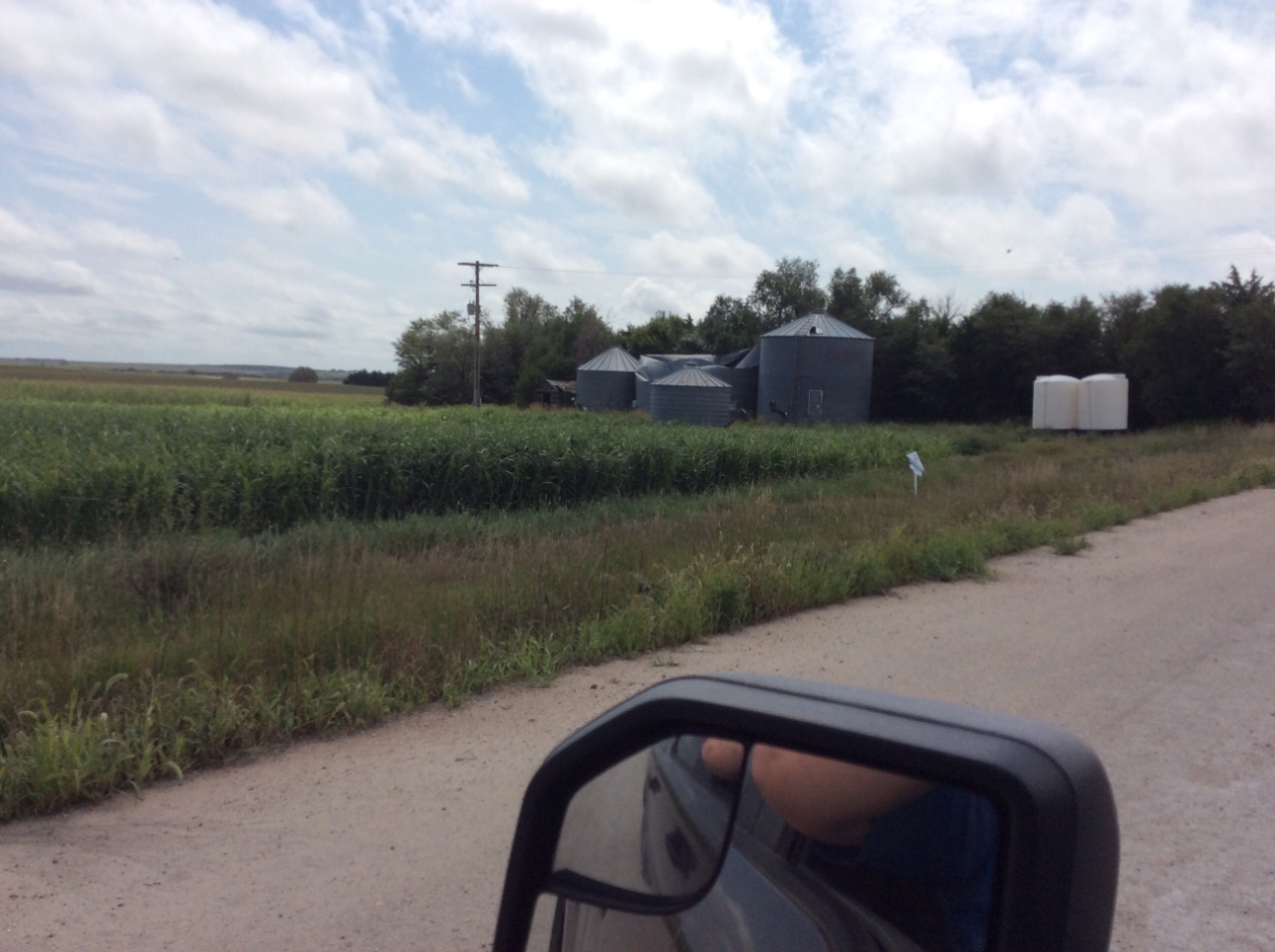
A powerful supercell thunderstorm moved across portions of southwest Nebraska and northwest Kansas on Thursday evening, August 29th, 2019. The storm formed in Lincoln County, NE, moving south into Hayes County, NE before moving into Hitchcock County, NE. Straight line wind damage was reported near Palisade, NE. The storm continued across Red Willow County, NE, and Rawlins, Decatur, Norton, Sheridan, and Graham Counties in northwest Kansas. Significant damage was reported in Graham County and this was consistent with straight line winds as well. The storm also produced many reports of hail, high winds, and torrential rainfall.
Thank you to NWS North Platte for conducting the storm survey in extreme northern Hitchcock County Nebraska. Thank you to the Graham County Sheriff's Department for leading the way for the storm survey in Graham County Kansas.
Storm Survey Reports:
|
Wind Damage - Palisade, NE
Track Map 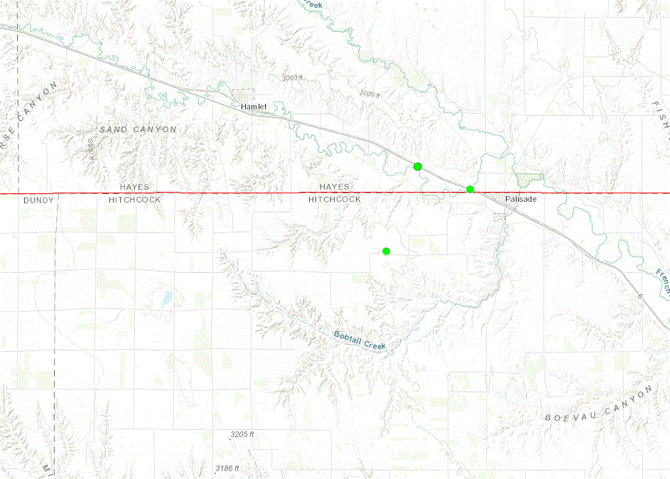 
|
||||||||||||||
|
Wind Damage - 5 SE New Almelo, KS to 8 NNE Morland, KS
Track Map 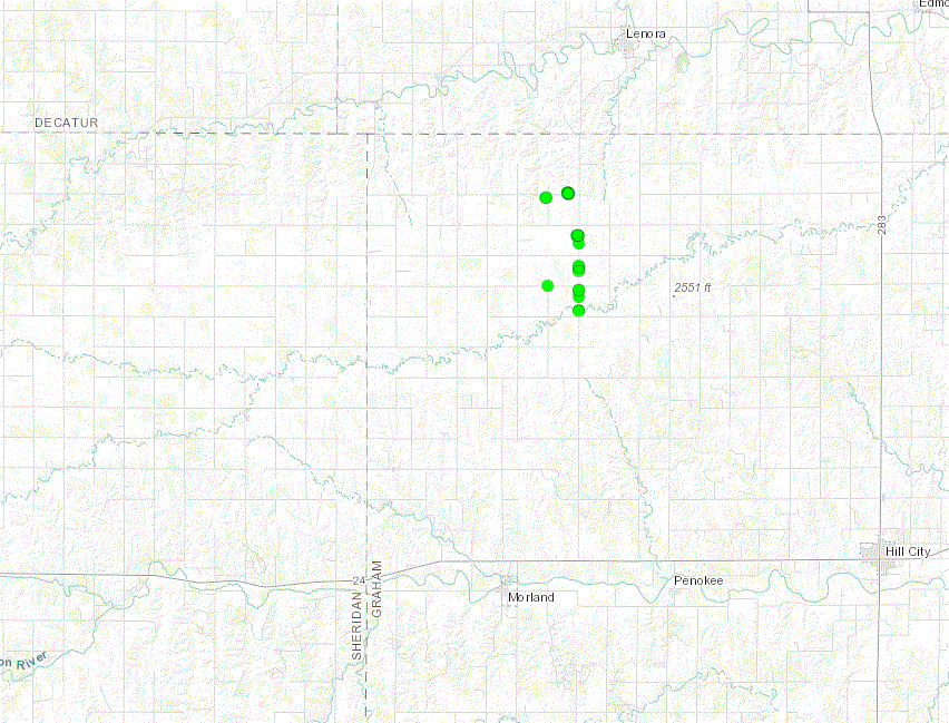
|
||||||||||||||
The Enhanced Fujita (EF) Scale classifies tornadoes into the following categories:
| EF0 Weak 65-85 mph |
EF1 Moderate 86-110 mph |
EF2 Significant 111-135 mph |
EF3 Severe 136-165 mph |
EF4 Extreme 166-200 mph |
EF5 Catastrophic 200+ mph |
 |
|||||
Photos & Video
Header
 |
 |
 |
 |
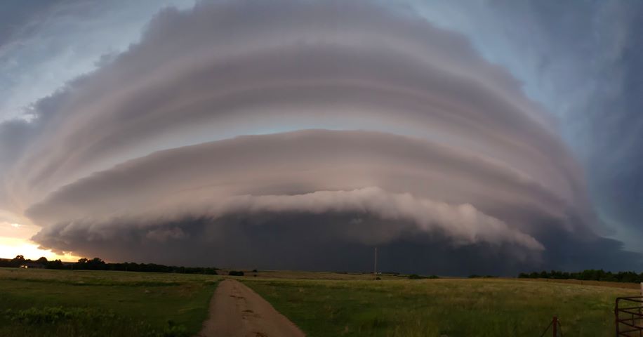
| Storm west of New Almelo, KS (Alissa Otter) |
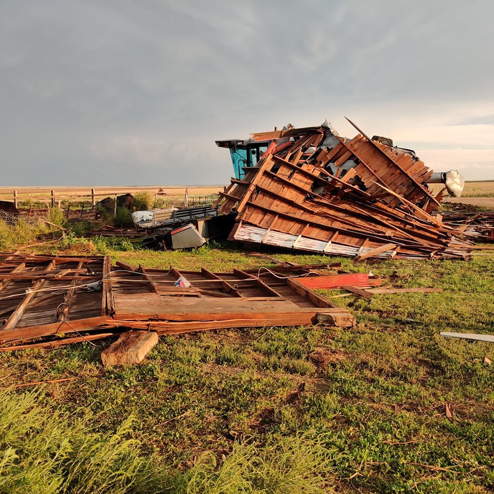
Rolled barn near Palisade, NE (Shane Gerhartz) |
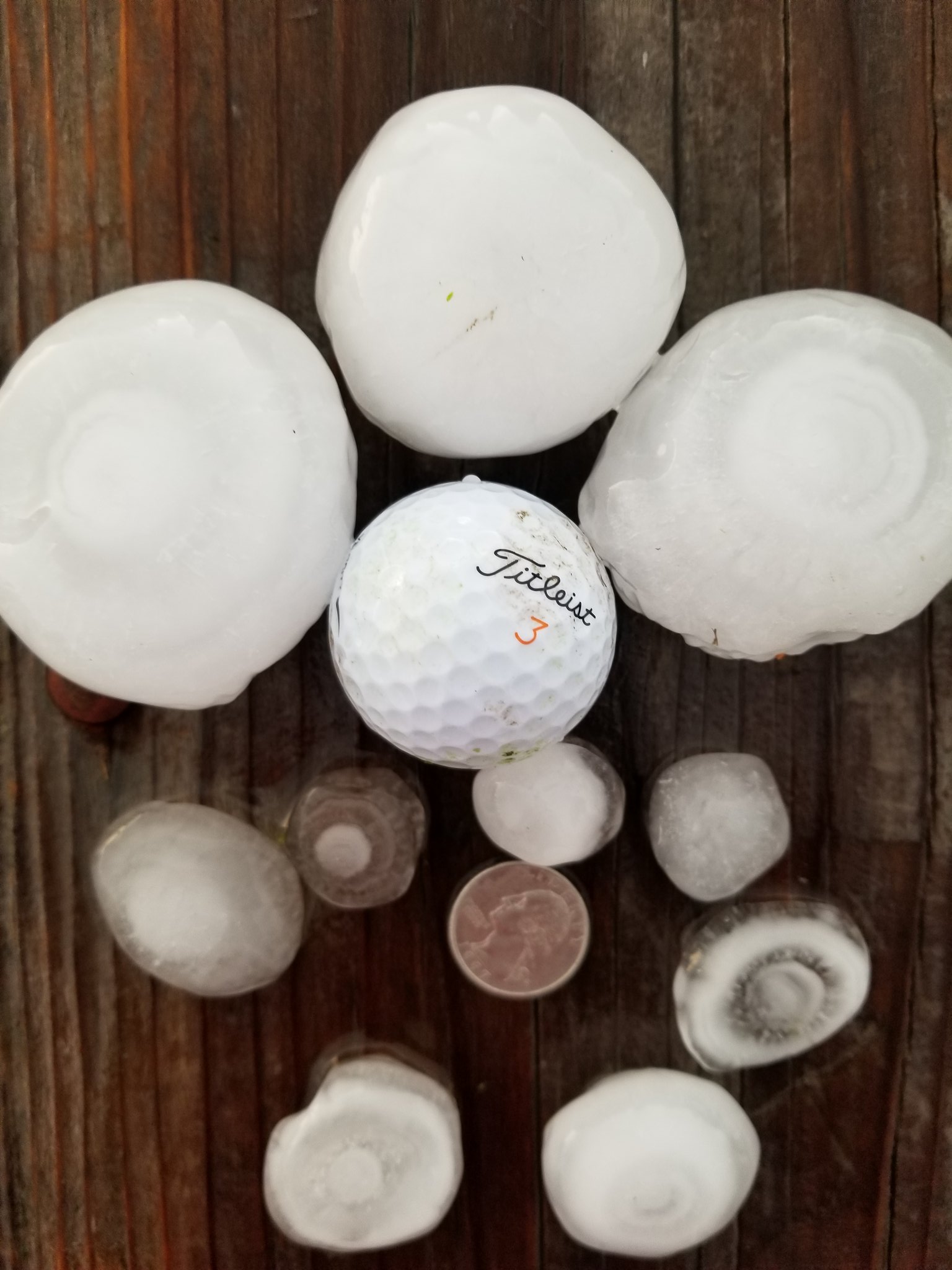
Hail west of Culbertson, NE (Adam Heskett) |
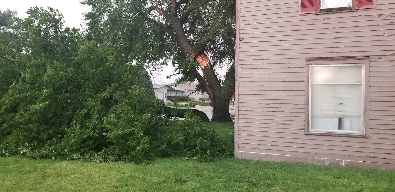
Tree damage in Oberlin, KS (John Kasey) |
 |
 |
 |
 |
| Wind damage near Norcatur, KS (Erica Kelley) |
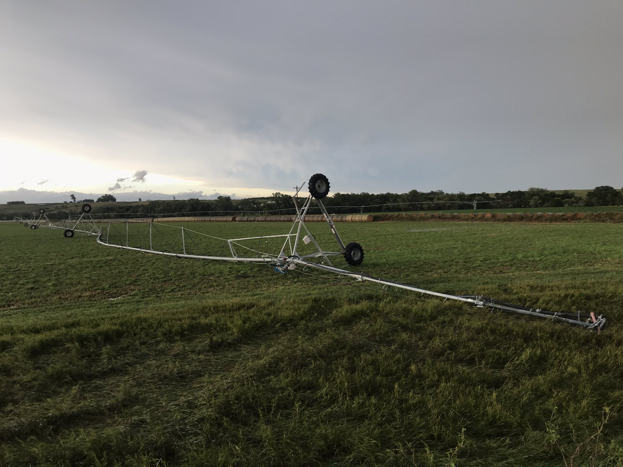
Overturned pivot near Culbertson, NE (Nathan Jurgensen) |
Wind damage - Graham County, KS (NWS Storm Survey) |
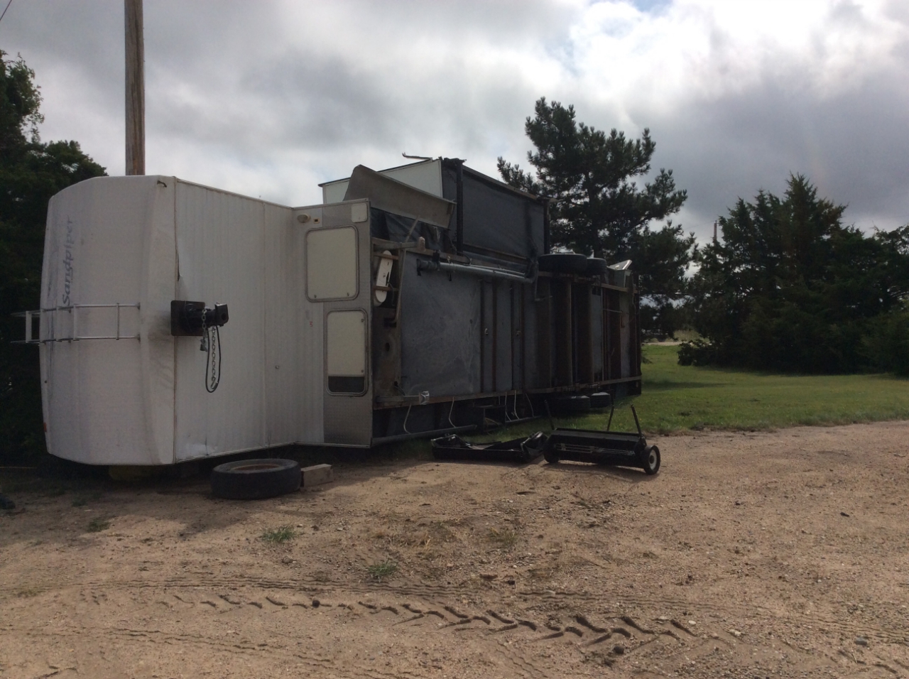
Flipped camper - Graham County, KS (NWS Storm Survey) |
 |
 |
 |
 |
| Wind damage - Graham County, KS (NWS Storm Survey) |
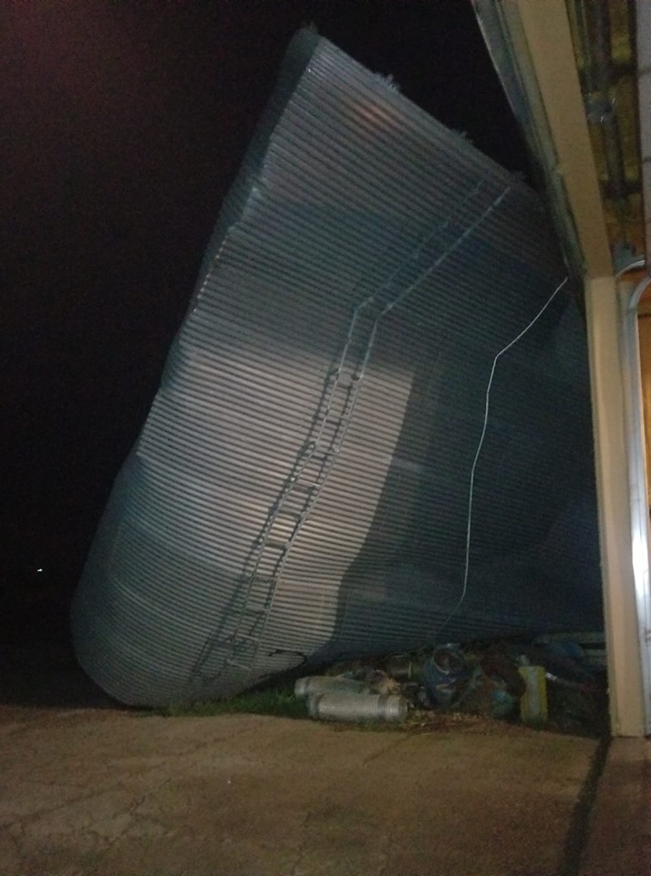
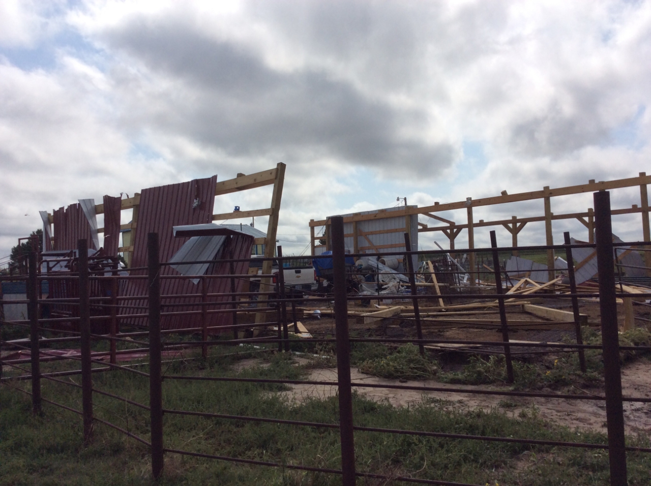
Damaged farm building - Graham County, KS (NWS Storm Survey) |
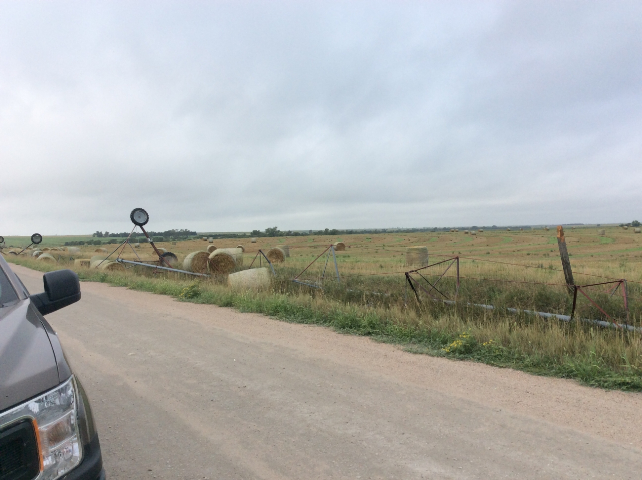
Overturned pivot and blown hay bales - Graham County, KS (NWS Storm Survey) |
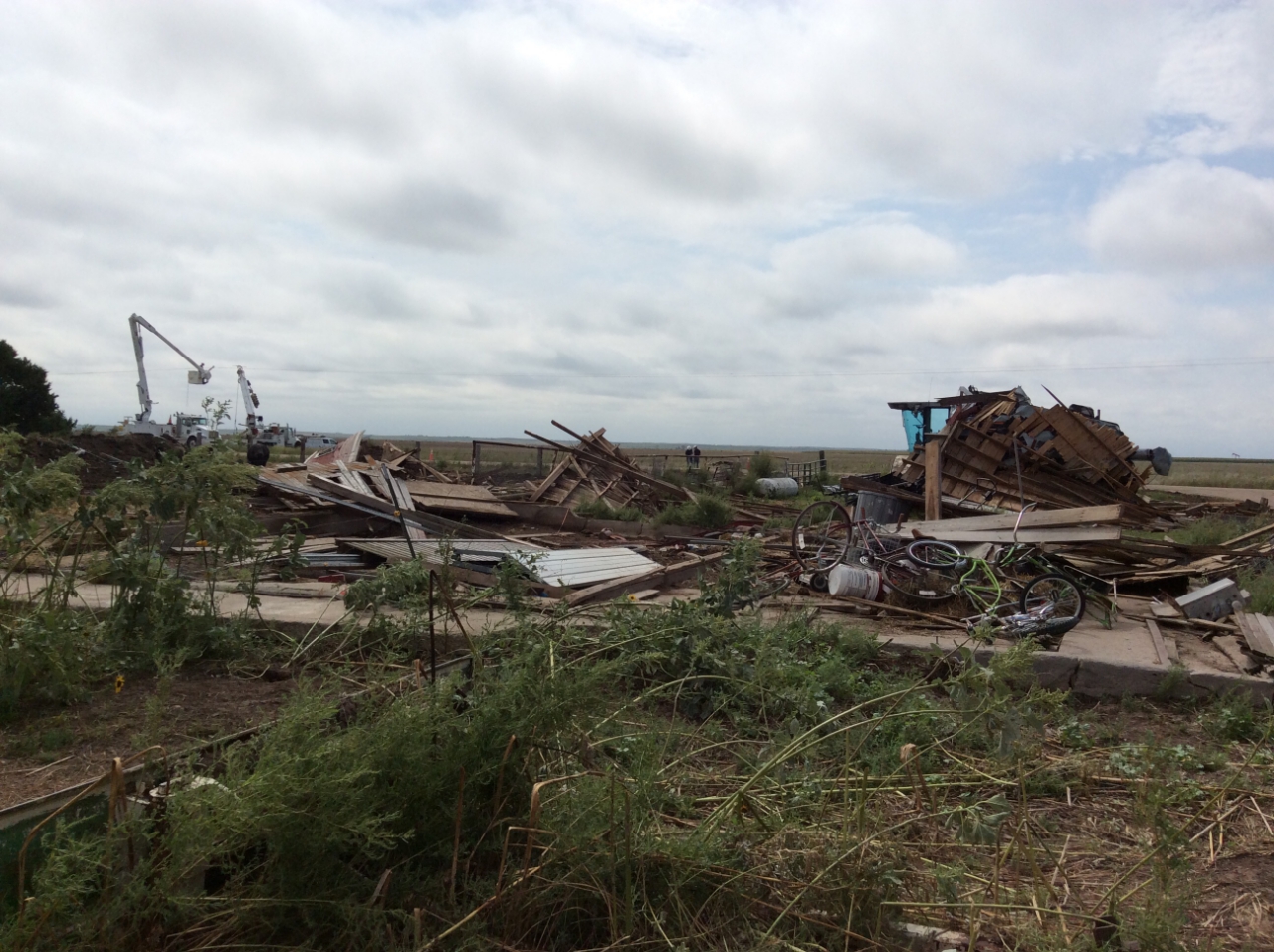
Destroyed farm building - Hitchcock County, NE (NWS Storm Survey) |
Radar
Header
 |
 |
 |
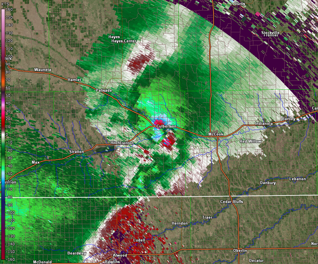 |
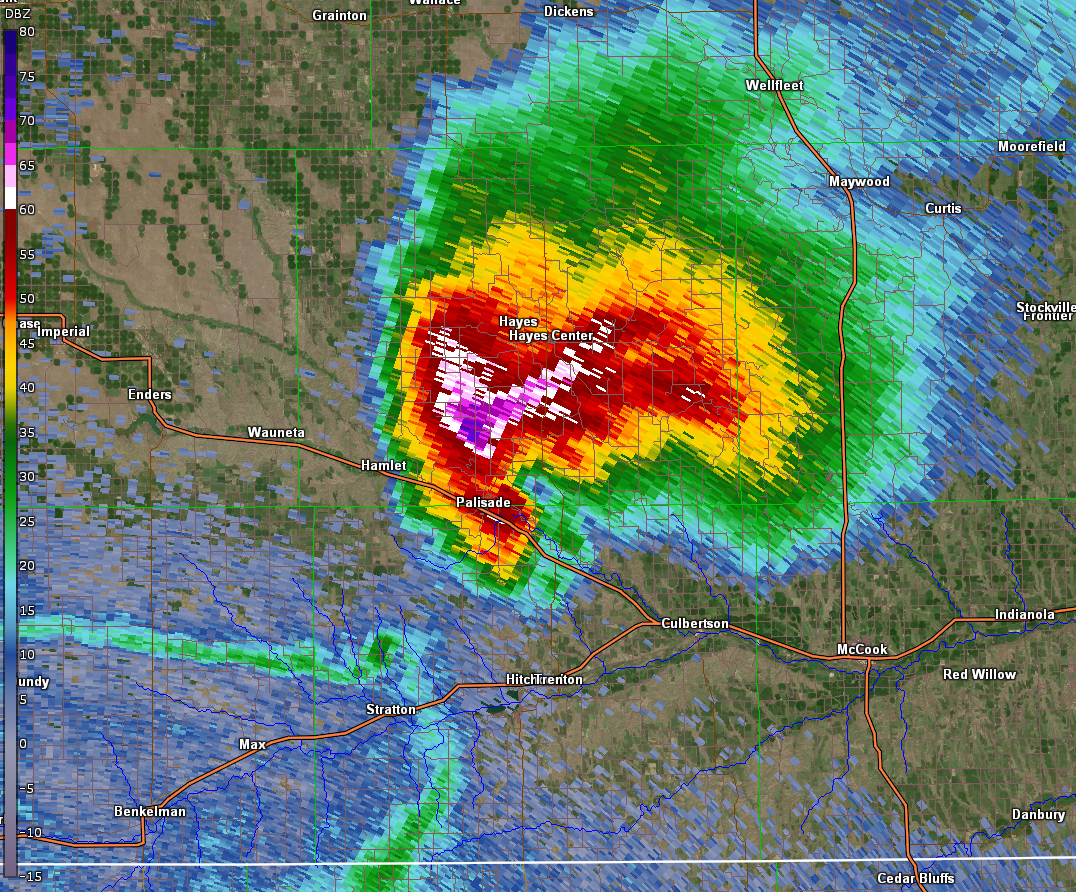
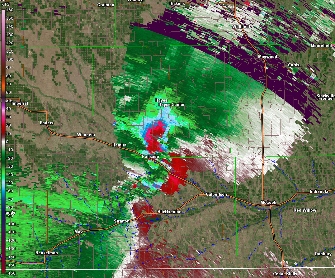
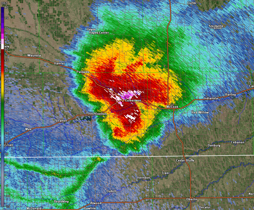
| Storm impacting Palisade, NE - Base Reflectivity | Storm impacting Palisade, NE - Storm Relative Velocity | Storm impacting Culbertson, NE - Base Reflectivity | Storm impacting Culbertson, NE - Storm Relative Velocity |
 |
 |
 |
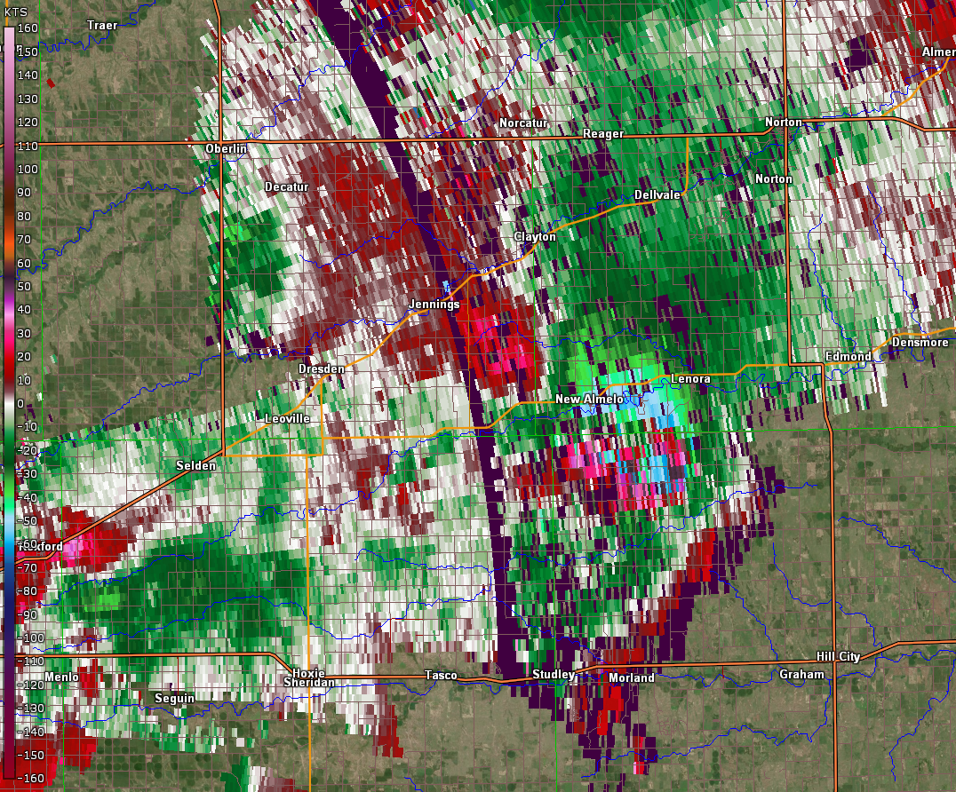 |
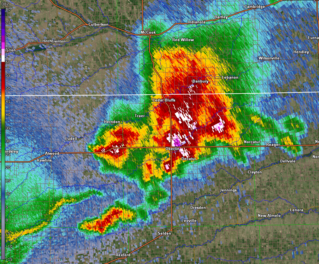
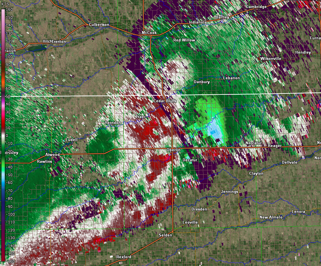
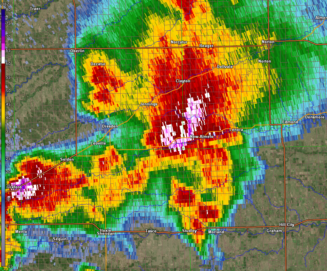
| Storm impacting Oberlin, KS - Base Reflectivity | Storm impacting Oberlin, KS - Storm Relative Velocity | Storm impacting New Almelo, KS - Base Reflectivity | Storm impacting New Almelo, KS - Storm Relative Velocity |
 |
 |
 |
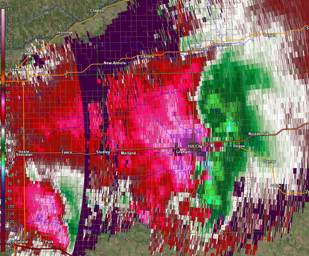 |
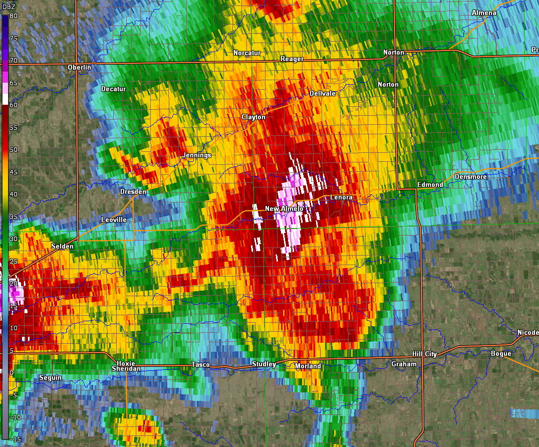
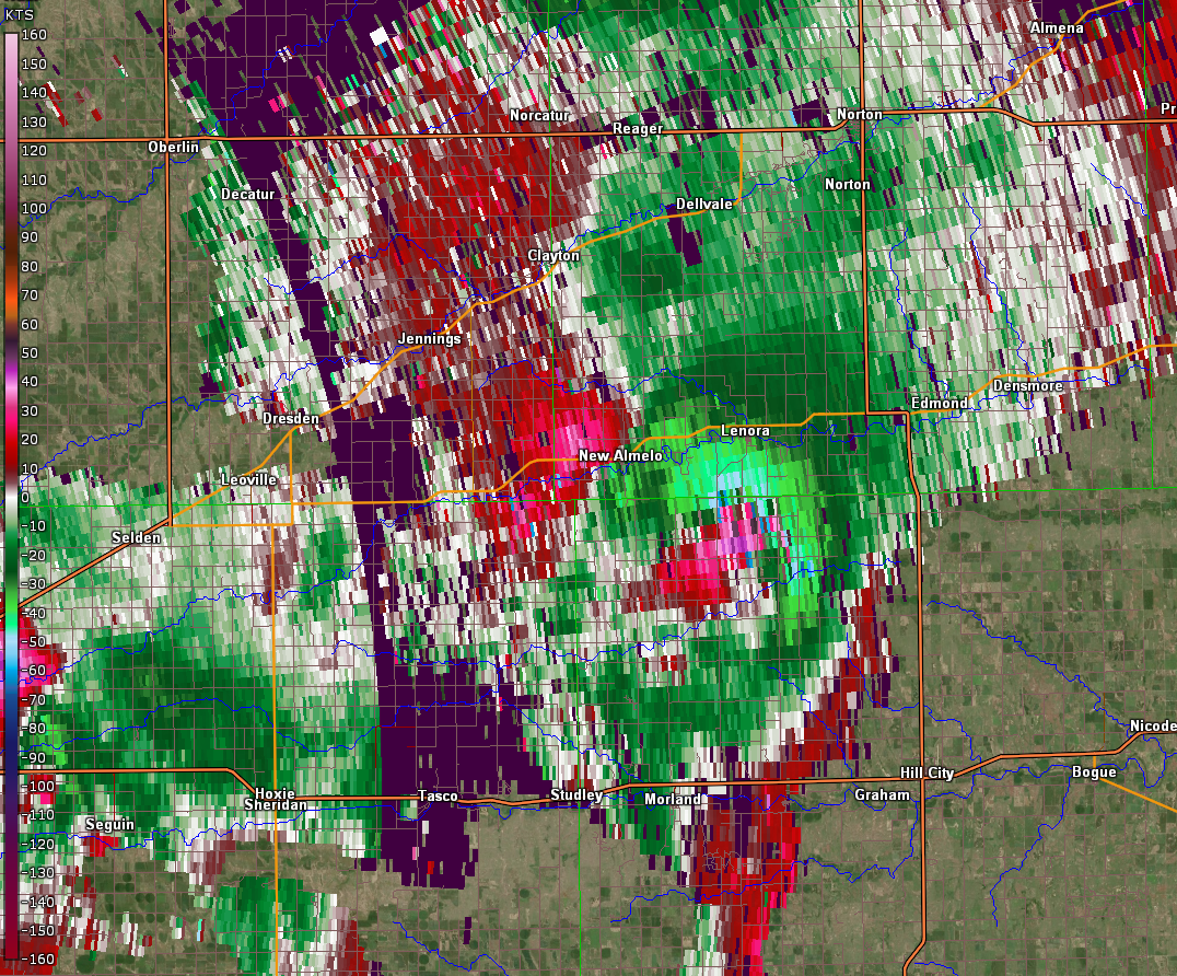
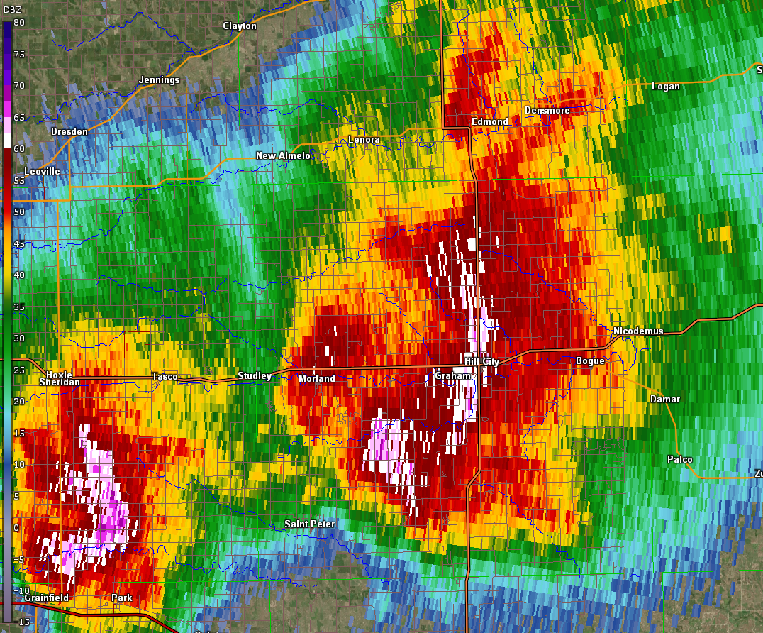
| Storm impacting NW Graham County Base Reflectivity | Storm impacting NW Graham County Storm Relative Velocity | Storm impacting Hill City, KS - Base Reflectivity | Storm impacting Hill City, KS - Storm Relative Velocity |
 |
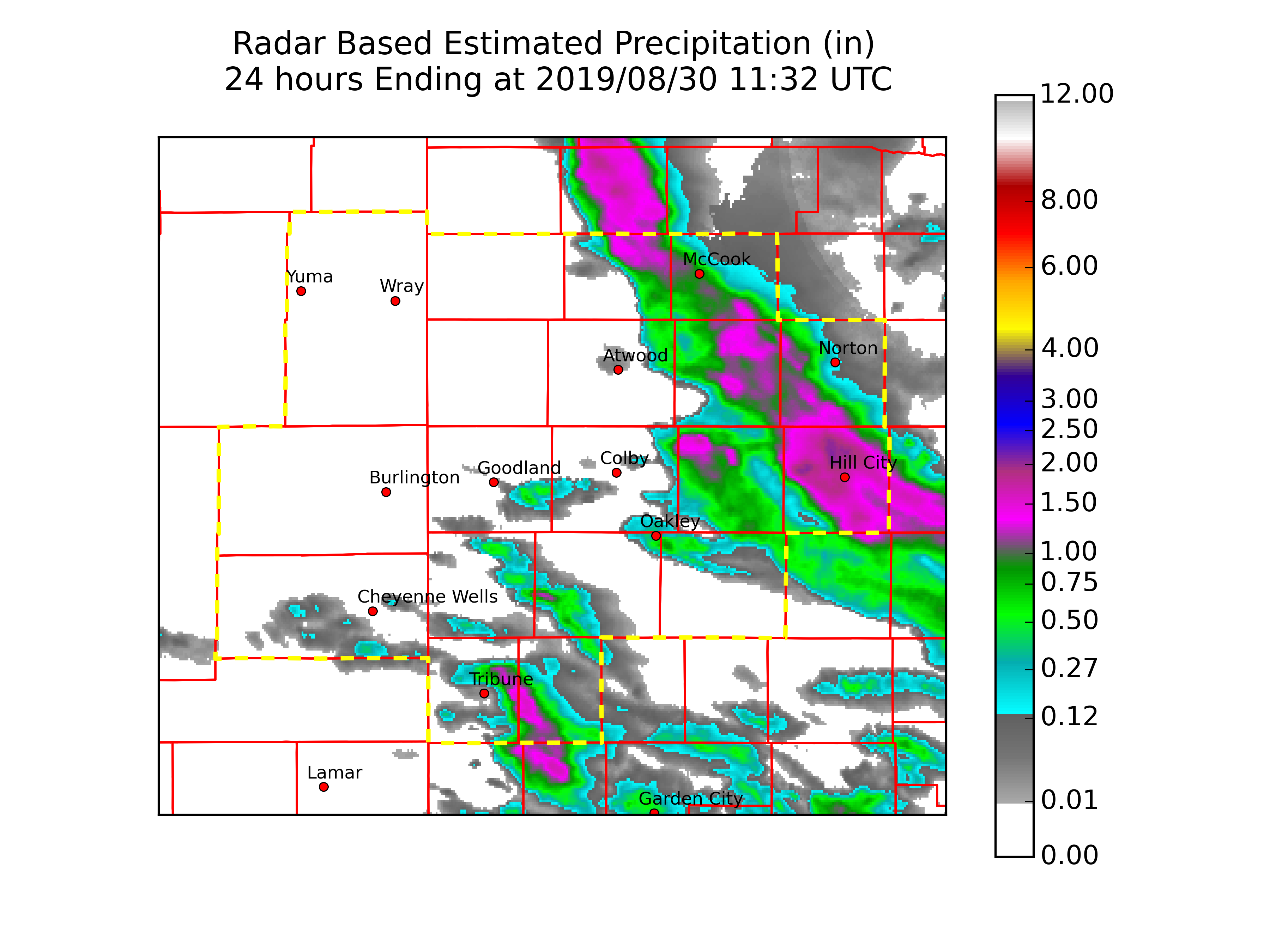 |
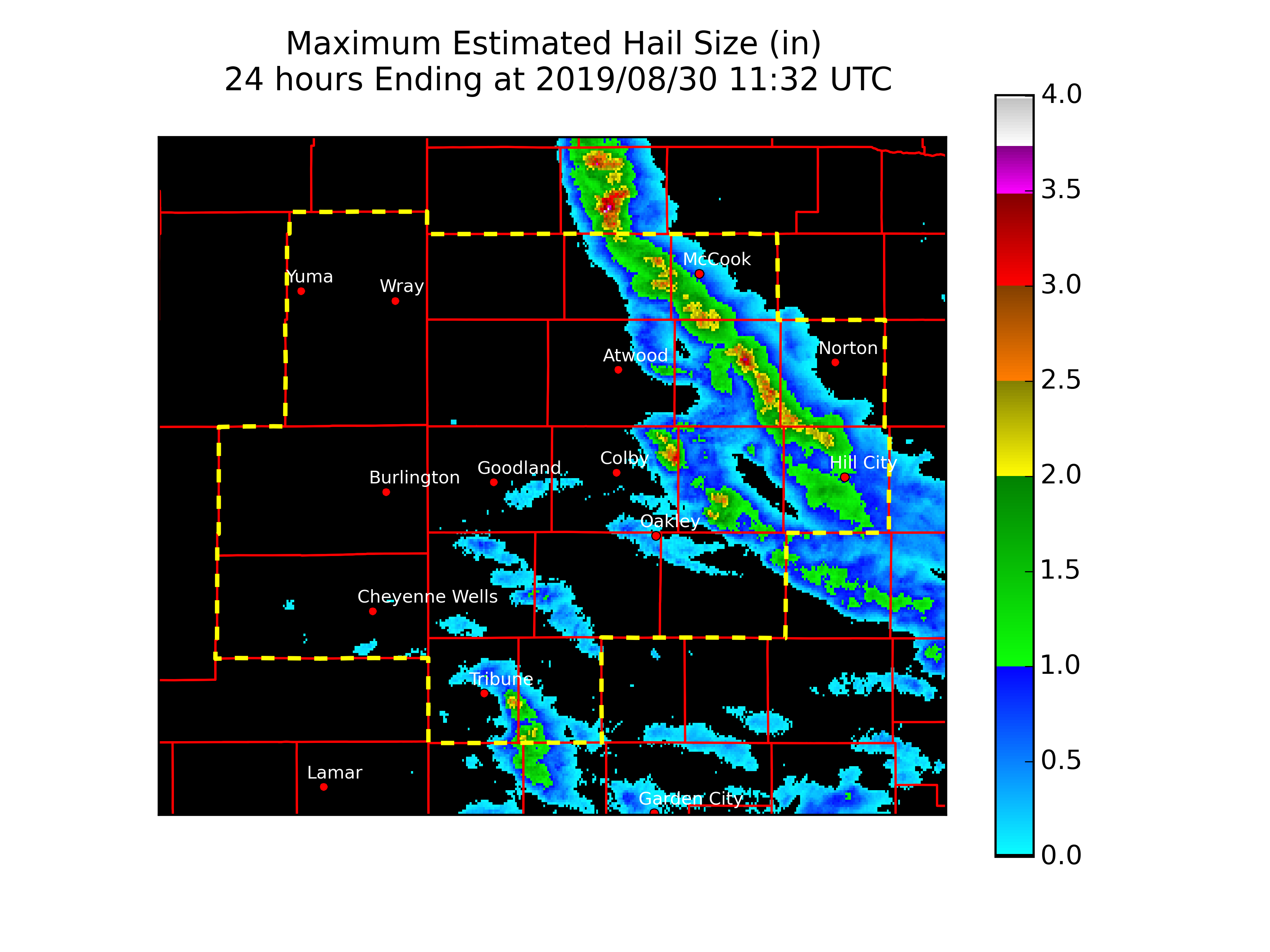
| Estimated hail swath courtesy NWS WSR-88D Radar Data | Estimated precipitation amounts courtesy NWS WSR-88D Radar Data |
Storm Reports
PRELIMINARY LOCAL STORM REPORT...SUMMARY
NATIONAL WEATHER SERVICE GOODLAND KS
245 PM MDT FRI AUG 30 2019
..TIME... ...EVENT... ...CITY LOCATION... ...LAT.LON...
..DATE... ....MAG.... ..COUNTY LOCATION..ST.. ...SOURCE....
..REMARKS..
0923 PM HEAVY RAIN 10 S HILL CITY 39.22N 99.85W
08/29/2019 E1.70 INCH GRAHAM KS PUBLIC
STORM TOTAL RAINFALL. VIA FACEBOOK.
0743 PM TSTM WND GST HILL CITY 39.37N 99.85W
08/29/2019 E60 MPH GRAHAM KS TRAINED SPOTTER
ALSO REPORTED UP TO DIME SIZE HAIL.
0743 PM TSTM WND GST 1 E HILL CITY 39.37N 99.83W
08/29/2019 M77 MPH GRAHAM KS ASOS
ASOS STATION KHLC HILL CITY.
0737 PM TSTM WND GST 1 E HILL CITY 39.37N 99.83W
08/29/2019 M66 MPH GRAHAM KS ASOS
ASOS STATION KHLC HILL CITY.
0725 PM HAIL 6 S SEGUIN 39.25N 100.59W
08/29/2019 E1.00 INCH SHERIDAN KS TRAINED SPOTTER
0714 PM TSTM WND GST MORLAND 39.35N 100.08W
08/29/2019 M58 MPH GRAHAM KS MESONET
0704 PM TSTM WND GST 1 NNE NEW ALMELO 39.61N 100.11W
08/29/2019 M72 MPH NORTON KS MESONET
0704 PM TSTM WND GST 1 WNW HOXIE 39.36N 100.45W
08/29/2019 M58 MPH SHERIDAN KS MESONET
0659 PM TSTM WND GST 6 SSE NEW ALMELO 39.51N 100.07W
08/29/2019 E105 MPH GRAHAM KS NWS STORM SURVEY
NWS STORM SURVEY CONFIRMS WIND DAMAGE
CONSISTENT WITH WINDS OF 90 TO 105 MPH.
SEVERAL FARMSTEADS LOST BUILDINGS, TREES,
POWER POLES, PIVOTS, FENCES, AND ROOFING
MATERIAL. A FEW GRAIN BINS WERE BLOWN OVER.
WORST DAMAGE NOTED IN NW GRAHAM COUNTY KS,
THE LOCATION OF THIS REPORT.
0652 PM HAIL REXFORD 39.47N 100.74W
08/29/2019 E1.00 INCH THOMAS KS TRAINED SPOTTER
0652 PM TSTM WND GST REXFORD 39.47N 100.75W
08/29/2019 E60 MPH THOMAS KS TRAINED SPOTTER
0638 PM HEAVY RAIN 10 S MCCOOK 40.06N 100.62W
08/29/2019 E1.21 INCH RED WILLOW NE PUBLIC
STORM TOTAL RAINFALL. VIA FACEBOOK.
0620 PM TSTM WND GST OBERLIN 39.82N 100.53W
08/29/2019 M68 MPH DECATUR KS TRAINED SPOTTER
0615 PM HAIL 5 SE LUDELL 39.81N 100.89W
08/29/2019 E1.75 INCH RAWLINS KS PUBLIC
REPORT VIA FACEBOOK WITH A PICTURE. TIME
ESTIMATED BASED ON RADAR.
0610 PM TSTM WND GST OBERLIN 39.82N 100.53W
08/29/2019 E60 MPH DECATUR KS PUBLIC
0600 PM TSTM WND GST OBERLIN 39.82N 100.53W
08/29/2019 E50 MPH DECATUR KS PUBLIC
ALSO REPORTED QUARTER SIZE HAIL.
0600 PM HAIL OBERLIN 39.82N 100.53W
08/29/2019 E1.00 INCH DECATUR KS PUBLIC
REPORT VIA FACEBOOK ALSO MENTIONED 50 MPH
WINDS.
0555 PM HAIL 11 W DANBURY 40.03N 100.62W
08/29/2019 E1.00 INCH RED WILLOW NE PUBLIC
DELAYED REPORT VIA FACEBOOK WITH A PICTURE.
0545 PM HAIL 7 SW MCCOOK 40.14N 100.72W
08/29/2019 E0.75 INCH RED WILLOW NE LAW ENFORCEMENT
0545 PM HAIL 10 S MCCOOK 40.06N 100.62W
08/29/2019 M1.50 INCH RED WILLOW NE PUBLIC
DELAYED REPORT VIA FACEBOOK. INCLUDES A
PICTURE OF HAIL NEXT TO MEASURING TAPE.
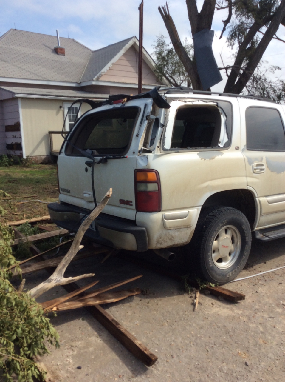
0545 PM TSTM WND DMG 7 S CULBERTSON 40.12N 100.82W
08/29/2019 HITCHCOCK NE NWS EMPLOYEE
REPORT VIA TWITTER WITH A PICTURE OF A LARGE
TREE DOWN.
0532 PM HAIL 10 SSE CULBERTSON 40.10N 100.75W
08/29/2019 E1.00 INCH RED WILLOW NE PUBLIC
0530 PM HAIL CULBERTSON 40.23N 100.84W
08/29/2019 E1.75 INCH HITCHCOCK NE PUBLIC
0525 PM HAIL CULBERTSON 40.23N 100.84W
08/29/2019 E1.75 INCH HITCHCOCK NE PUBLIC
0524 PM TSTM WND GST 3 WNW TRENTON 40.19N 101.07W
08/29/2019 M65 MPH HITCHCOCK NE MESONET
0524 PM HAIL 2 WNW CULBERTSON 40.23N 100.88W
08/29/2019 E2.00 INCH HITCHCOCK NE PUBLIC
DELAYED REPORT VIA TWITTER SHOWING A PICTURE
OF 2 INCH HAIL. TIME ESTIMATED BASED ON
RADAR.
0524 PM TSTM WND DMG 3 W CULBERTSON 40.23N 100.88W
08/29/2019 HITCHCOCK NE NWS EMPLOYEE
REPORT VIA TWITTER WITH A PICTURE OF AN
OVERTURNED PIVOT. TIME ESTIMATED BASED ON
RADAR.
0520 PM HAIL 5 SSE CULBERTSON 40.16N 100.80W
08/29/2019 E1.25 INCH HITCHCOCK NE TRAINED SPOTTER
0519 PM TSTM WND GST 3 WSW CULBERTSON 40.22N 100.89W
08/29/2019 M72 MPH HITCHCOCK NE MESONET
0515 PM TSTM WND DMG 6 SE PALISADE 40.30N 101.01W
08/29/2019 HITCHCOCK NE NWS EMPLOYEE
DELAYED REPORT...ROAD SIGN RIPPED OUT OF THE
GROUND. TIME ESTIMATED BASED ON RADAR.
0511 PM HAIL 5 N CULBERTSON 40.30N 100.84W
08/29/2019 E1.50 INCH HITCHCOCK NE FIRE DEPT/RESCUE
0510 PM TSTM WND DMG 6 NW TRENTON 40.23N 101.10W
08/29/2019 HITCHCOCK NE PUBLIC
POWER LINES DOWN 8 MILES SOUTH OF PALISADE.
REPORT VIA TWITTER WITH A PICTURE.
0510 PM TSTM WND DMG 2 ENE TRENTON 40.19N 100.97W
08/29/2019 HITCHCOCK NE PUBLIC
DELAYED REPORT VIA FACEBOOK OF A ROOF RIPPED
OFF A BARN NEAR TRENTON. TIME ESTIMATED
BASED ON RADAR.
0503 PM TSTM WND DMG 6 SE PALISADE 40.30N 101.01W
08/29/2019 HITCHCOCK NE FIRE DEPT/RESCUE
TREE DAMAGE AND POWER LINES DOWN AT HWY 6
AND HWY 25.
0500 PM HAIL PALISADE 40.35N 101.11W
08/29/2019 M1.75 INCH HITCHCOCK NE PUBLIC
REPORT INCLUDED A PICTURE OF GOLF-BALL SIZE
HAIL.
0455 PM TORNADO 4 E PALISADE 40.34N 101.03W
08/29/2019 HITCHCOCK NE PUBLIC
REPORT OF FUNNEL CLOUD/POSSIBLE TORNADO AND
ROTATION WITH THE STORM 1 MILE SOUTH AND 2
MILES WEST OF THE HAYES/HITCHCOCK COUNTY
LINE NEAR OLD HWY 17.
0450 PM TSTM WND GST 4 WSW PALISADE 40.32N 101.16W
08/29/2019 E105 MPH HITCHCOCK NE NWS STORM SURVEY
STORM SURVEY BY NWS NORTH PLATTE CONFIRMS
STRAIGHT LINE WIND DAMAGE TO A FARM
SOUTHWEST OF PALISADE. A BARN WAS COMPLETELY
DESTROYED, AS WELL AS TREES SNAPPED, TREE
LIMBS DOWN, POWER POLES DOWN, AND CROPS
DOWN.
 |
Media use of NWS Web News Stories is encouraged! Please acknowledge the NWS as the source of any news information accessed from this site. |
|

