Heat expands across the Desert Southwest, Plains, Mississippi Valley and Midwest into Monday. Fire weather concerns continue for portions of the Intermountain West. Active monsoonal moisture fuels thunderstorms over the Southwest with possible flash flooding. Tropical cyclone Fausto in the Pacific, should weaken as it approaches Hawaii; Dangerous surf, swells and rip currents are expected. Read More >
Overview
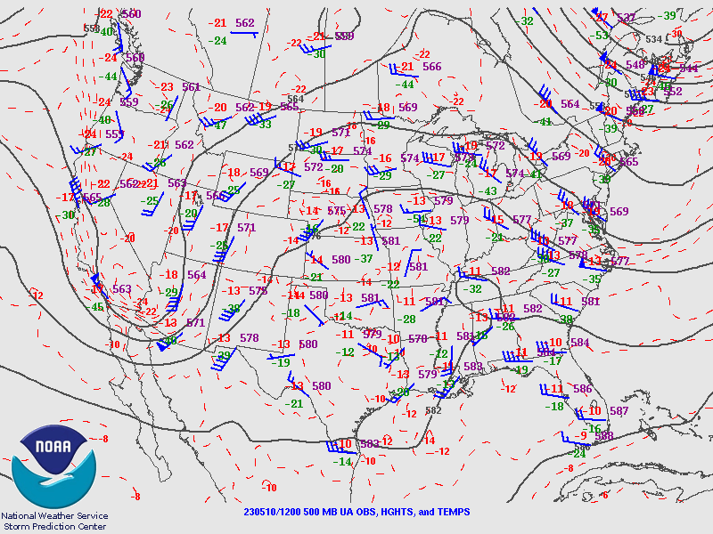
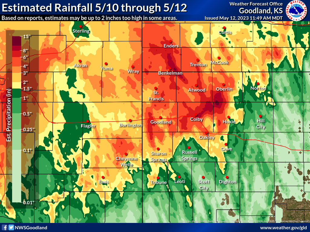
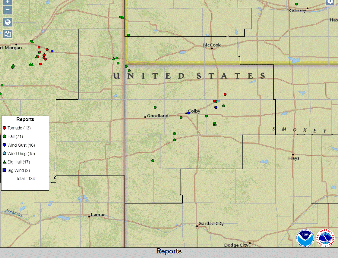
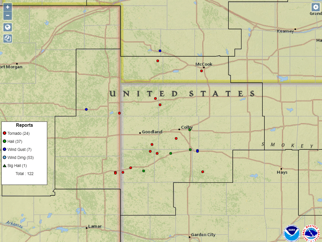
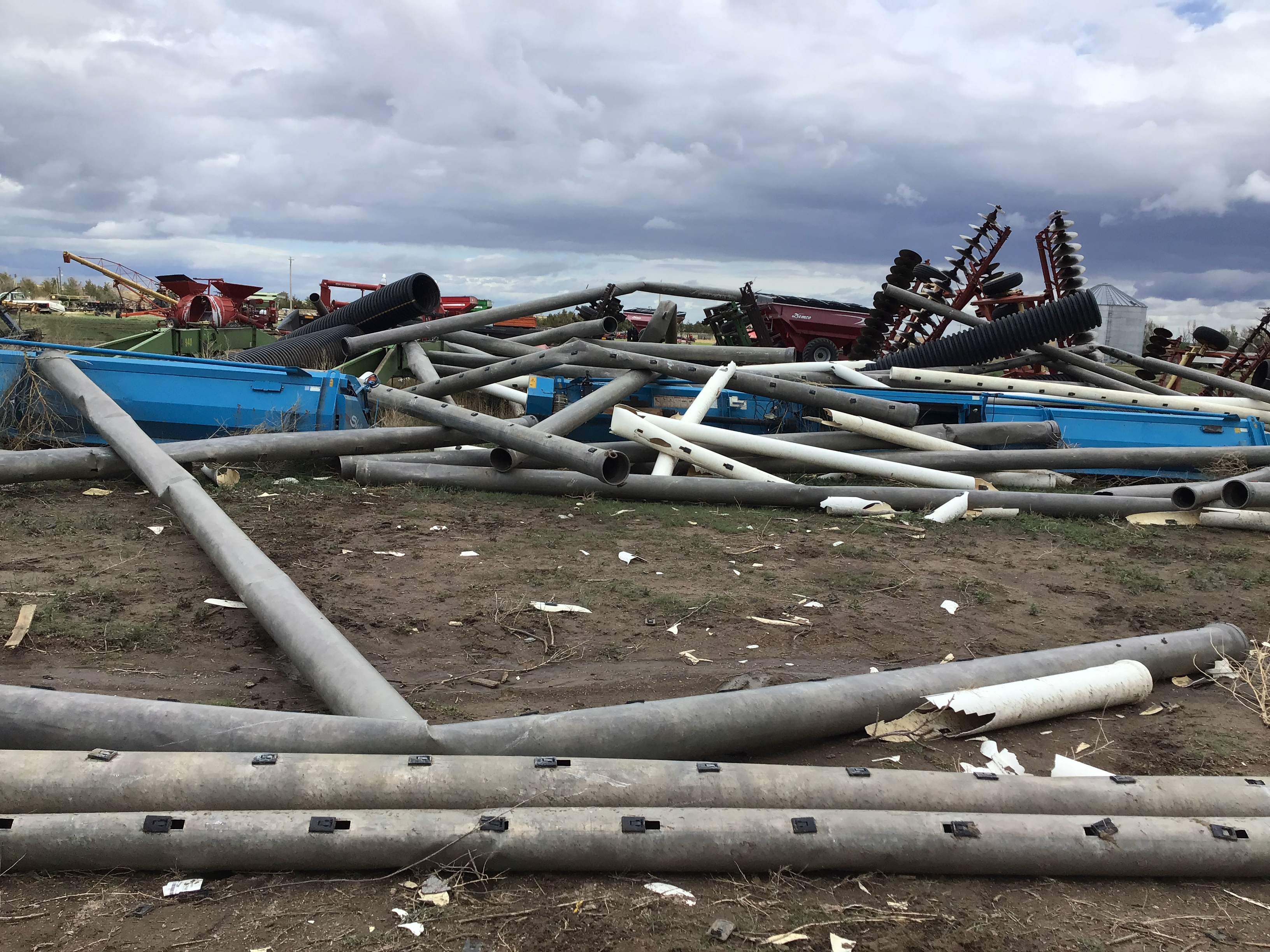
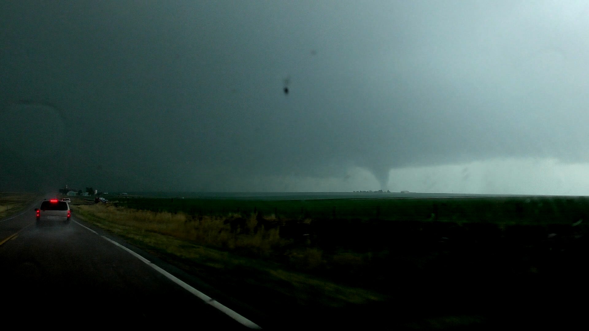
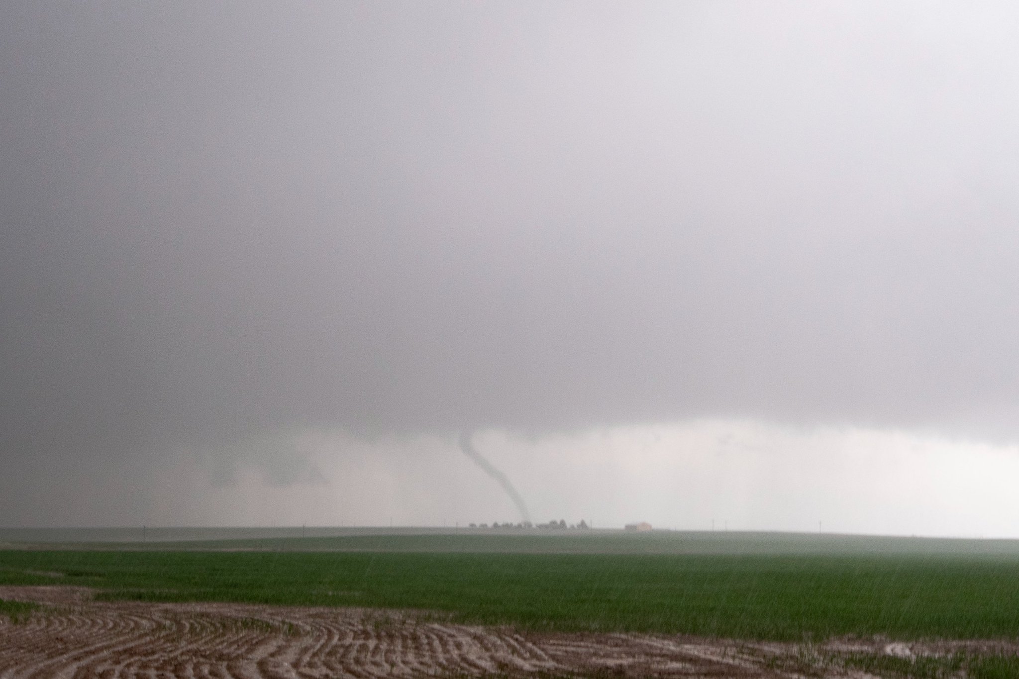
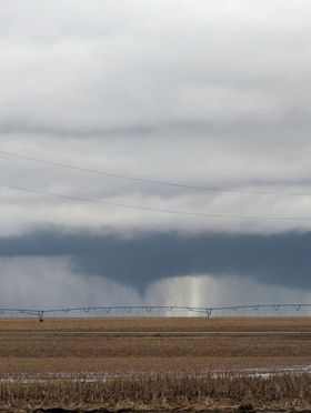
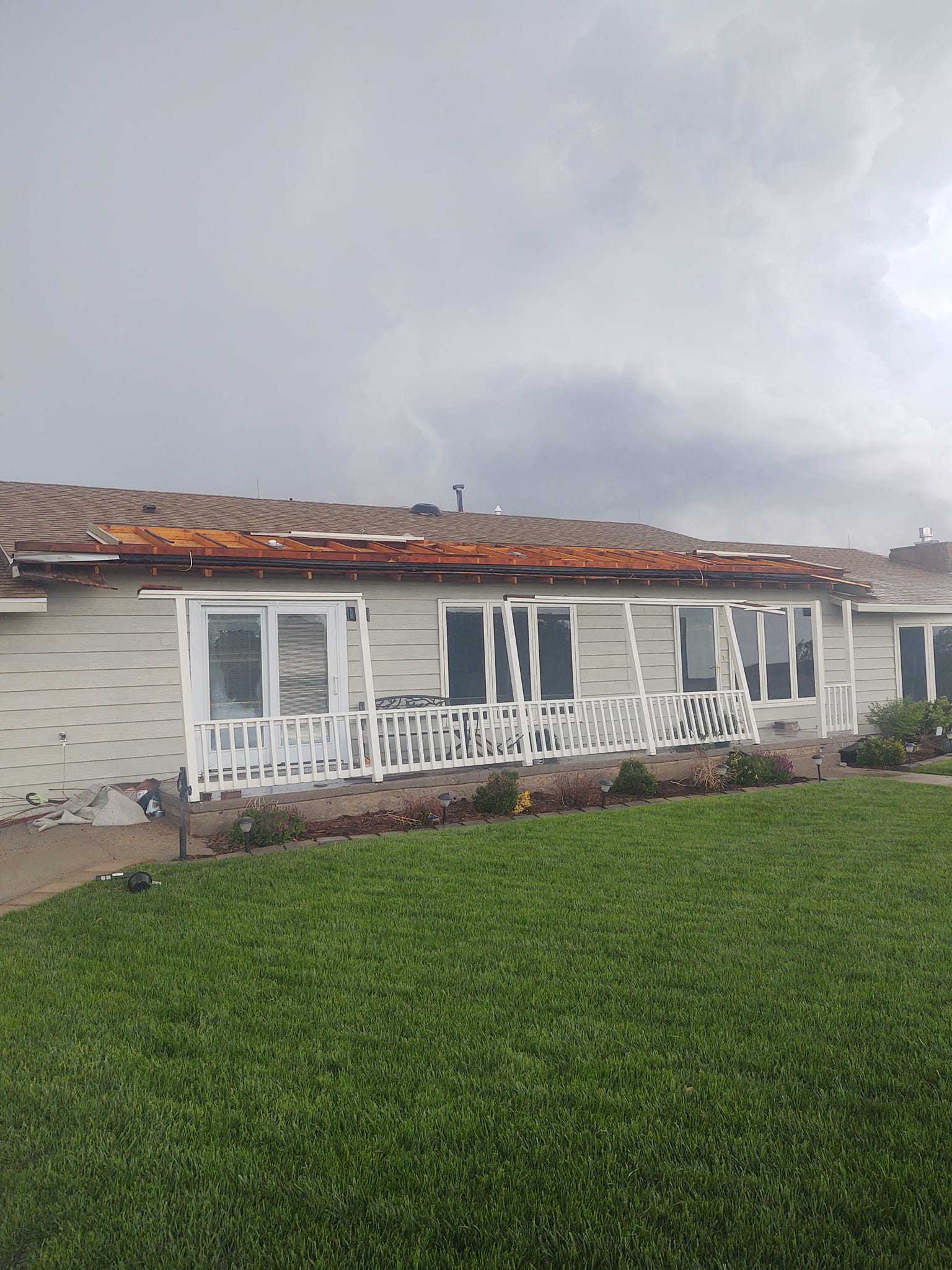
A powerful upper level storm system slowly moved across the plains, leading to several rounds of severe thunderstorms and very heavy rain across the Tri-State area (Figure 1 and 2). This systems slow movement allowed for multiple rounds of thunderstorms leading to numerous locations receiving several inches of rain, resulting in widespread flooding (Figure 3). Numerous severe thunderstorms occurred each day, with very large hail and damaging winds prevailing on May 10th and numerous tornadoes on May 11th (Figure 4 and 5).
 |
 |
| 6 AM MDT May 10 2022 500mb Heights/Winds | 6 AM MDT May 11 2022 500mb Heights/Winds |
 |
 |
| Estimated Rainfall from Radar | May 10th Storm Reports |
 |
|
| May 11th Storm Reports |
Downloadable KMZ File for all tornado and wind data for this event here!
Tornadoes and Wind Damage (in chronological order):
|
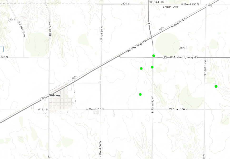
Wind Damage - Near Selden, KS
|
||||||||||||||
|
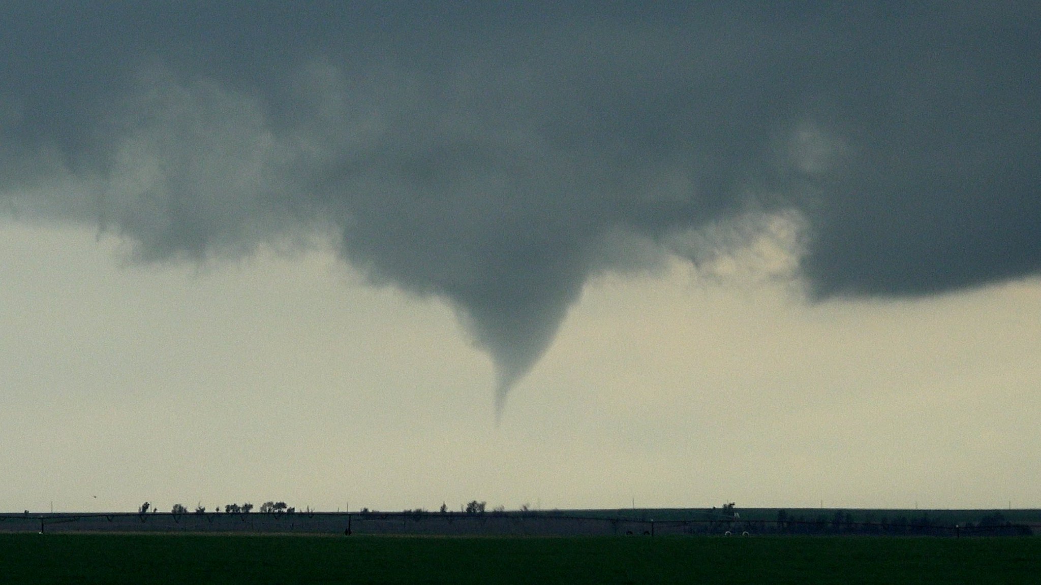
Tornado - Near Selden, KS
|
||||||||||||||||
|
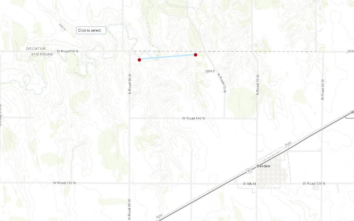
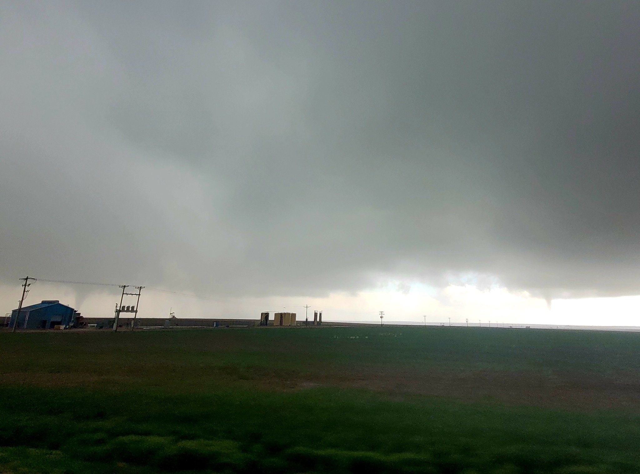
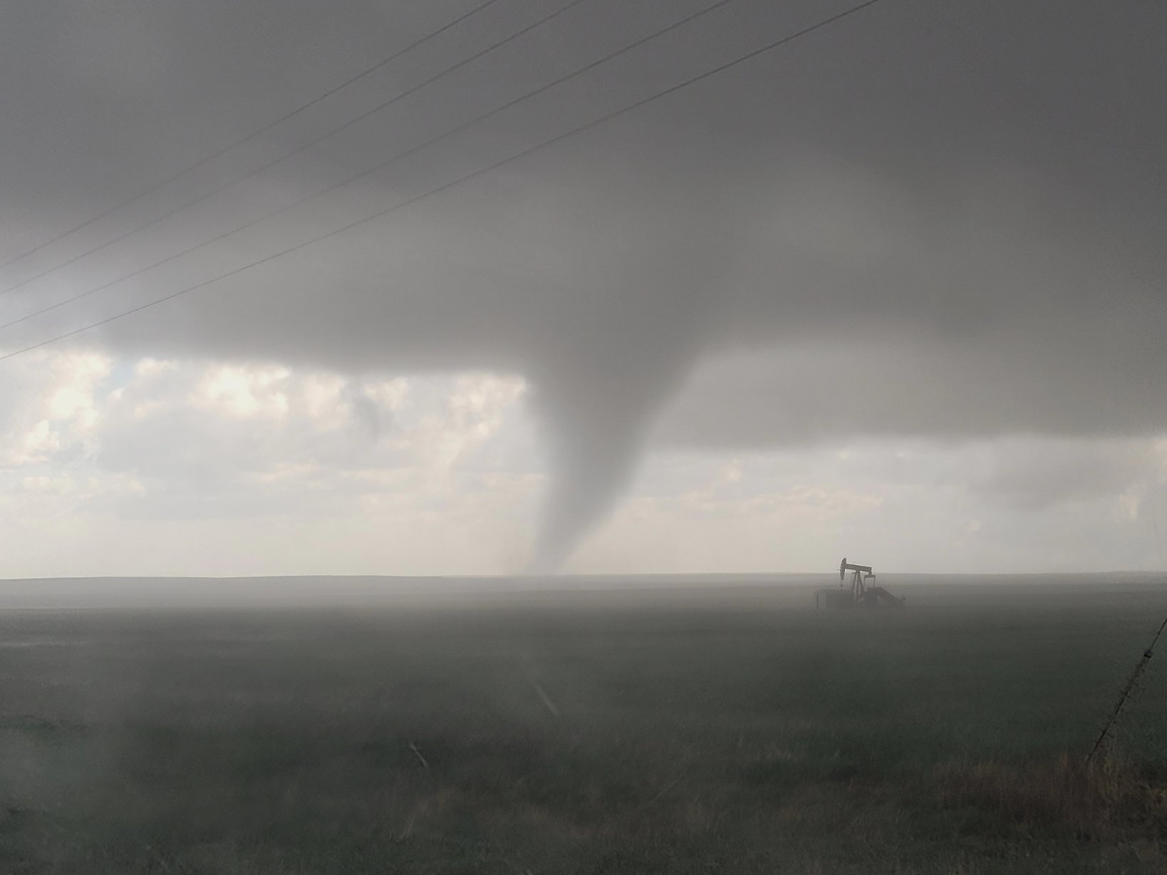
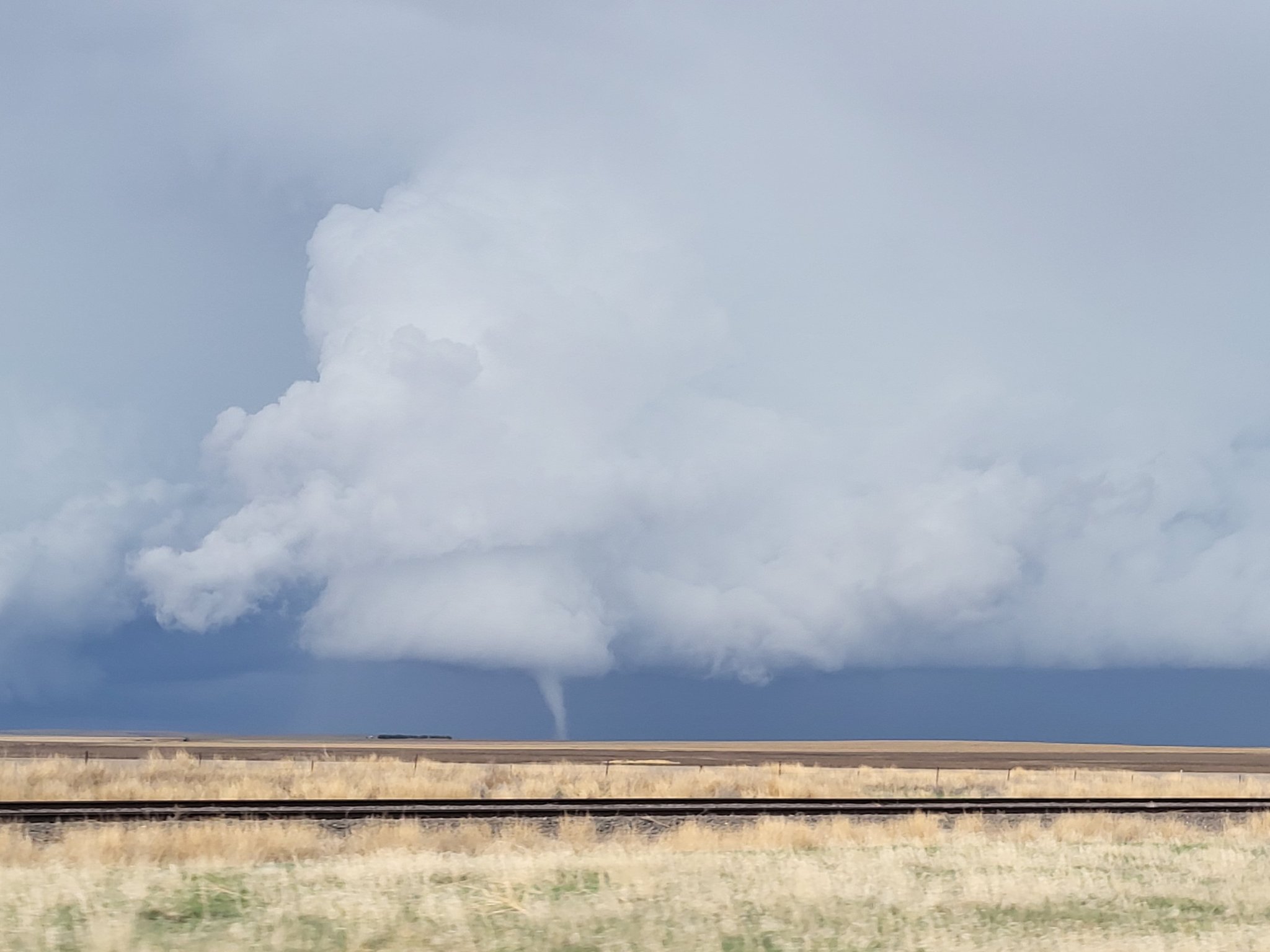
Tornado - Cheyenne KS to Yuma CO
|
||||||||||||||||
|
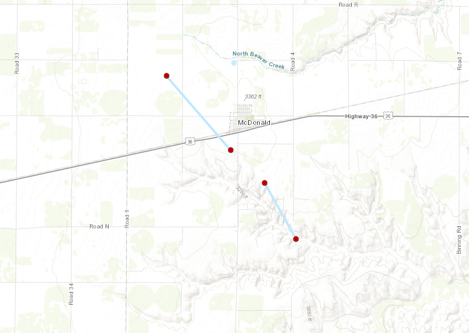
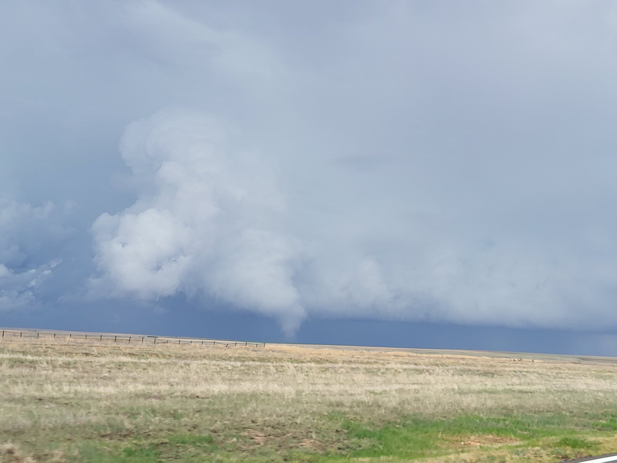
Tornado - South of McDonald, KS
|
||||||||||||||||
|
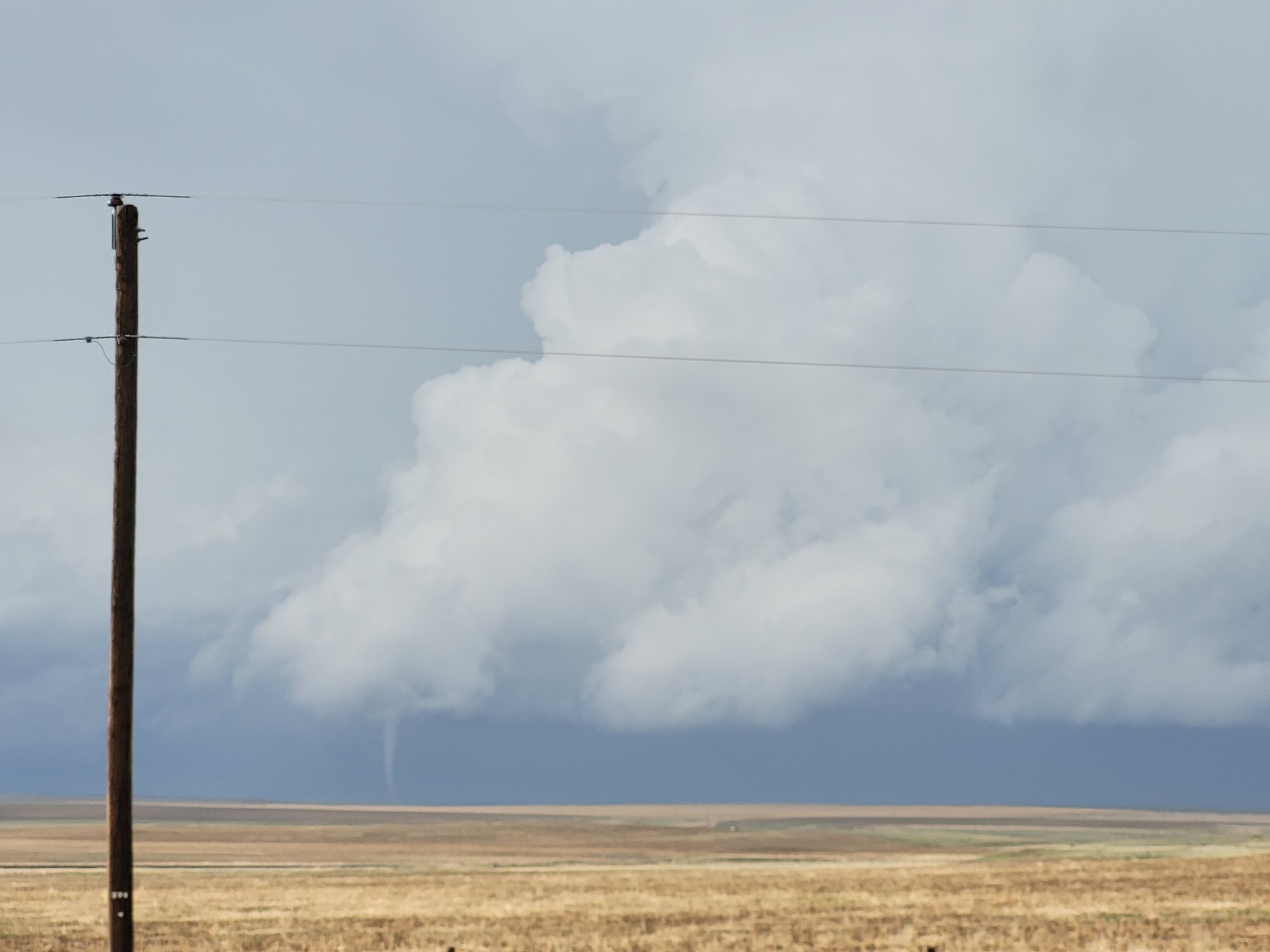
Tornado - West of McDonald, KS
|
||||||||||||||||
|
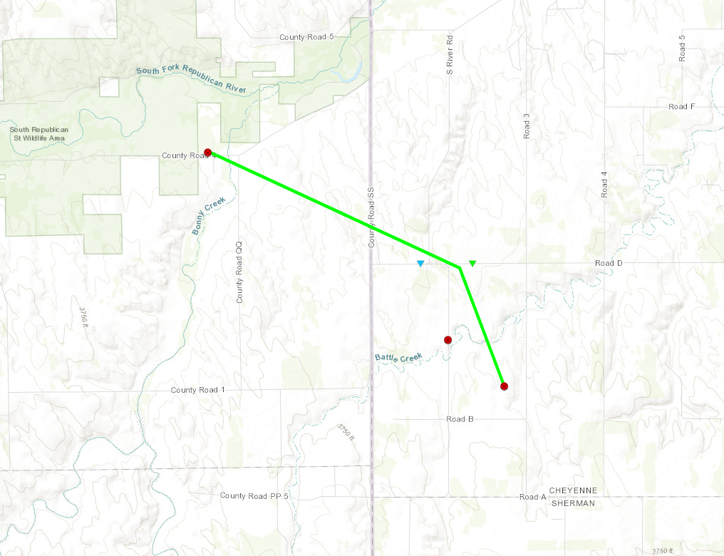
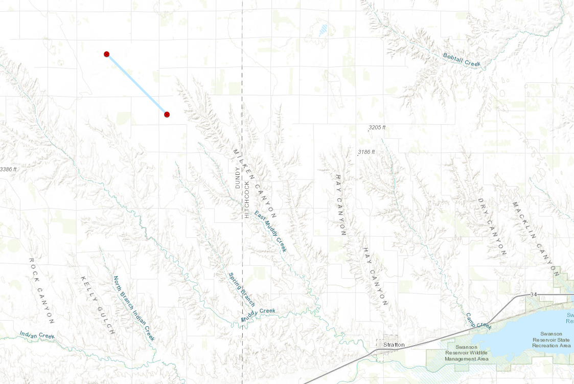
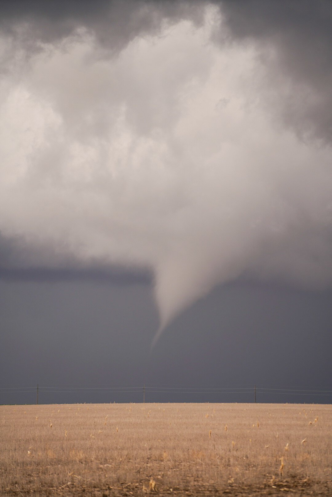
Tornado - Northeast Dundy County
|
||||||||||||||||
|
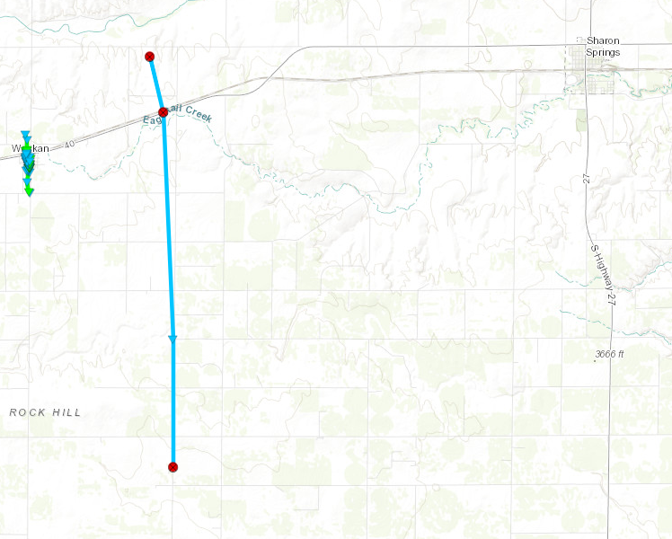
Tornado - West of Sharon Springs, KS
|
||||||||||||||||
|
Tornado - State Line Tornado
|
||||||||||||||||
|
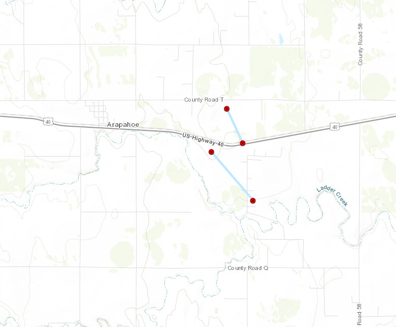
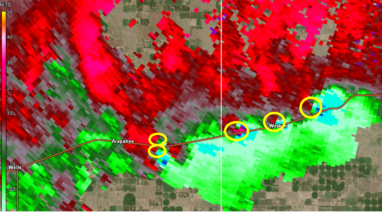
Tornado - Southeast of Arapahoe, CO
|
||||||||||||||||
|
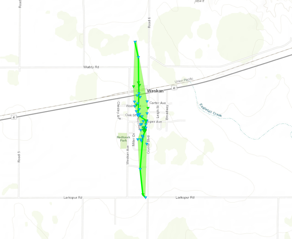
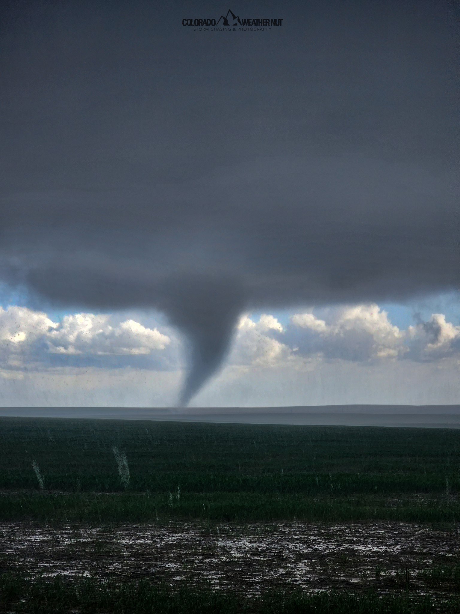
Tornado - Weskan, KS
|
||||||||||||||||
|
Tornado - East of Arapahoe, CO
|
||||||||||||||||
|
Tornado - North of Sharon Springs, KS
|
||||||||||||||||
|
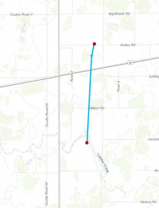
Tornado - North of McAllaster, KS
|
||||||||||||||||
|
Tornado - South of Edson, KS
|
||||||||||||||||
|
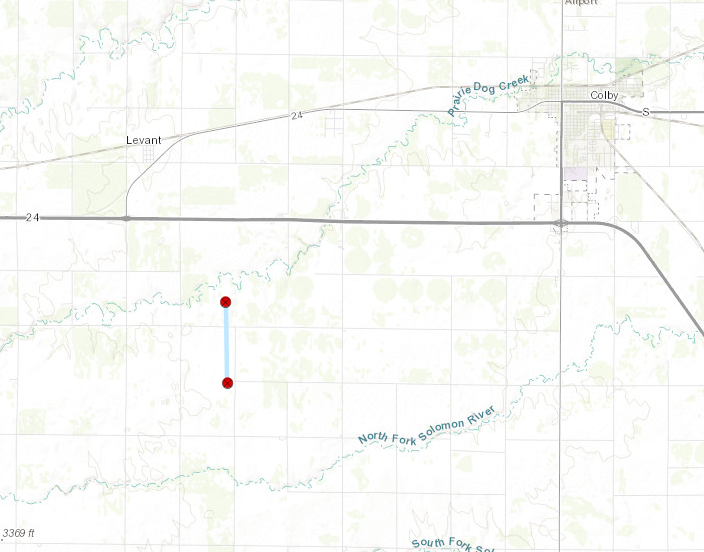
Tornado - South of Levant, KS
|
||||||||||||||||
The Enhanced Fujita (EF) Scale classifies tornadoes into the following categories:
| EF0 Weak 65-85 mph |
EF1 Moderate 86-110 mph |
EF2 Significant 111-135 mph |
EF3 Severe 136-165 mph |
EF4 Extreme 166-200 mph |
EF5 Catastrophic 200+ mph |
 |
|||||
Photos & Video
May 11th, 2023 Weskan, KS Tornado
 |
 |
 |
 |
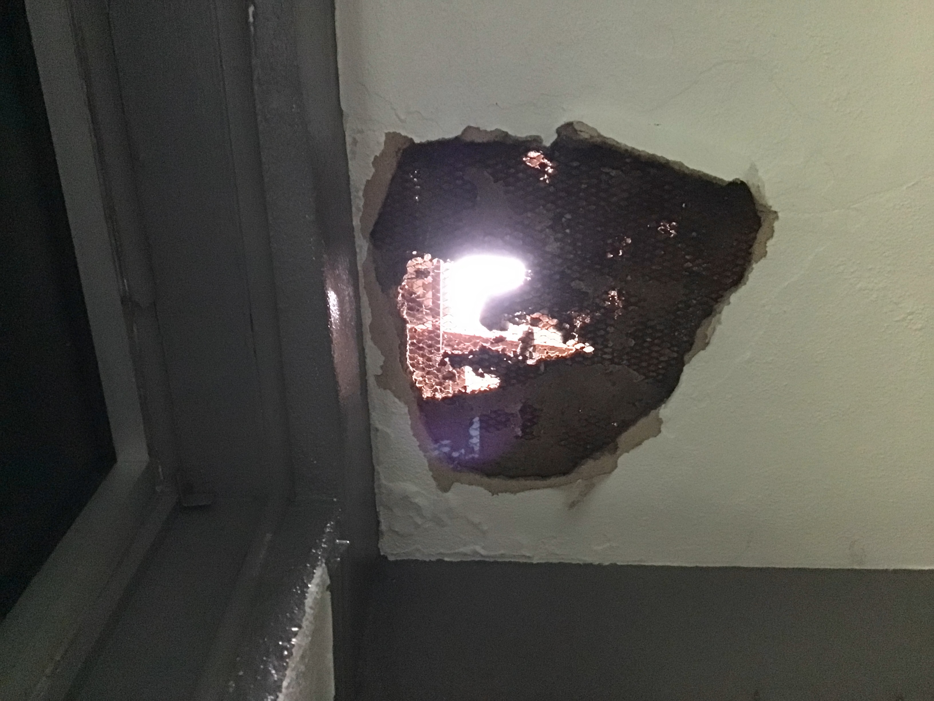
| Weskan Tornado - Hole In Ceiling (NWS Survey) |
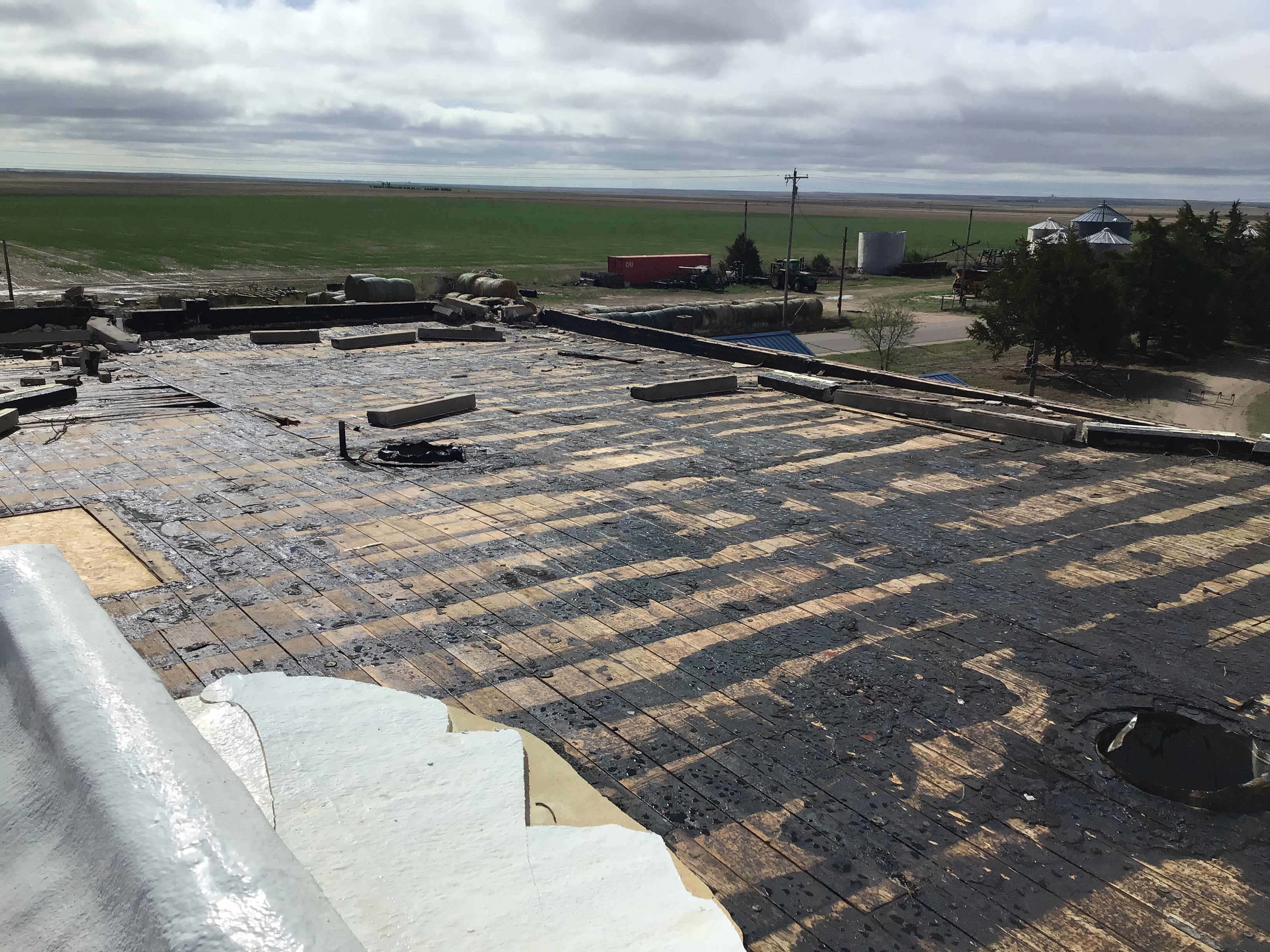
Weskan Tornado - Roof Peeled Off (NWS Survey) |
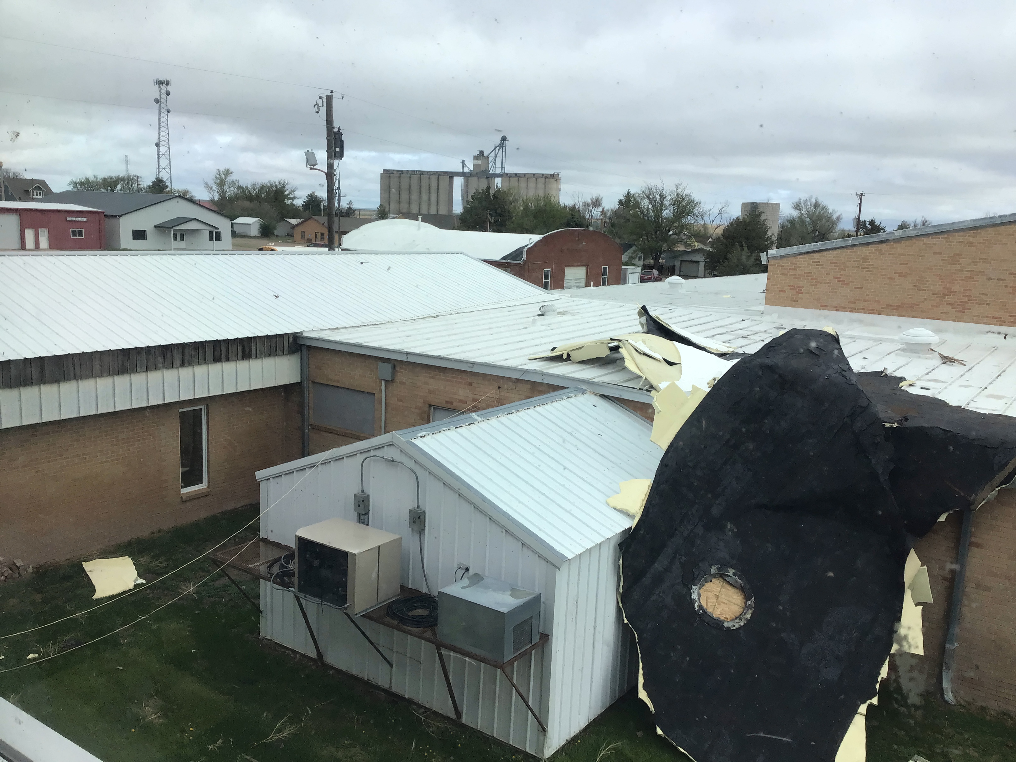
Weskan Tornado - Roof In Courtyard (NWS Survey) |
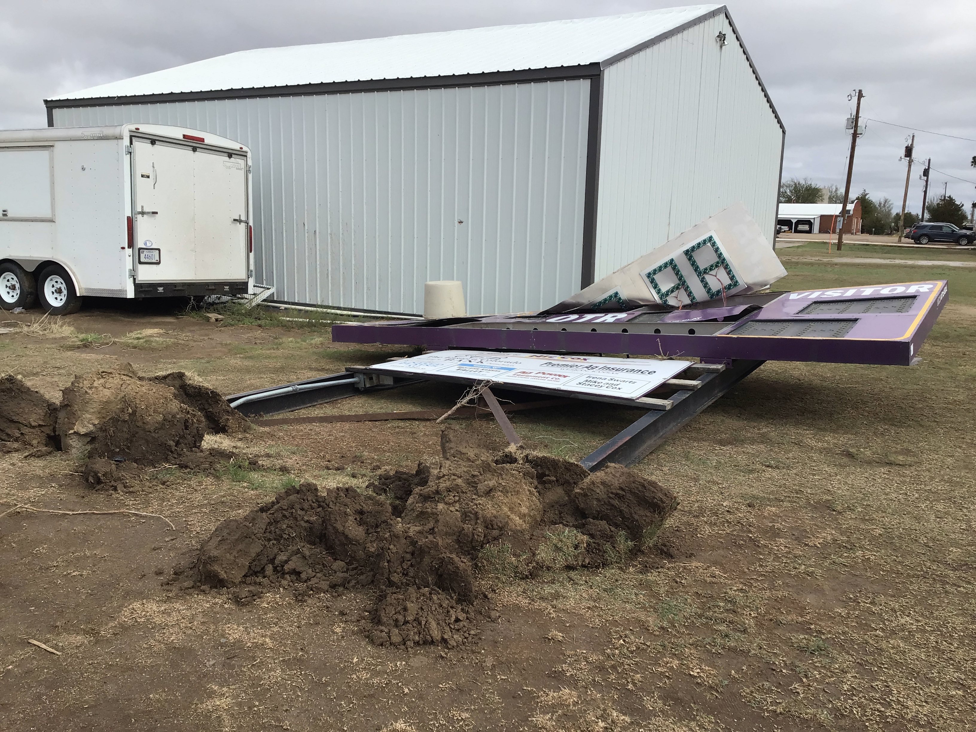
Weskan Tornado - Scoreboard Knocked Doqwn (NWS Survey) |
 |
 |
 |
 |
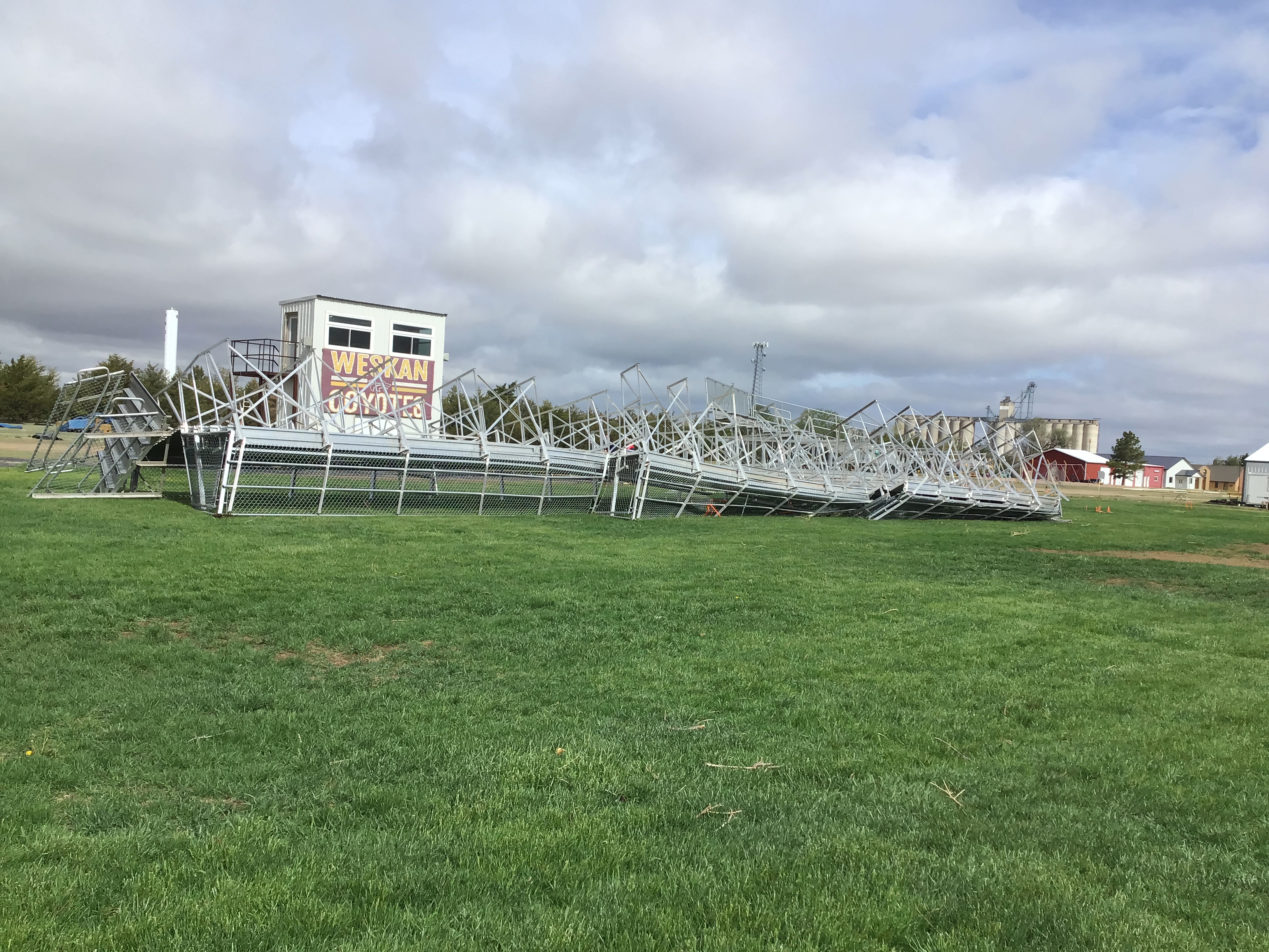
| Weskan Tornado - Bleachers Tossed (NWS Survey) |
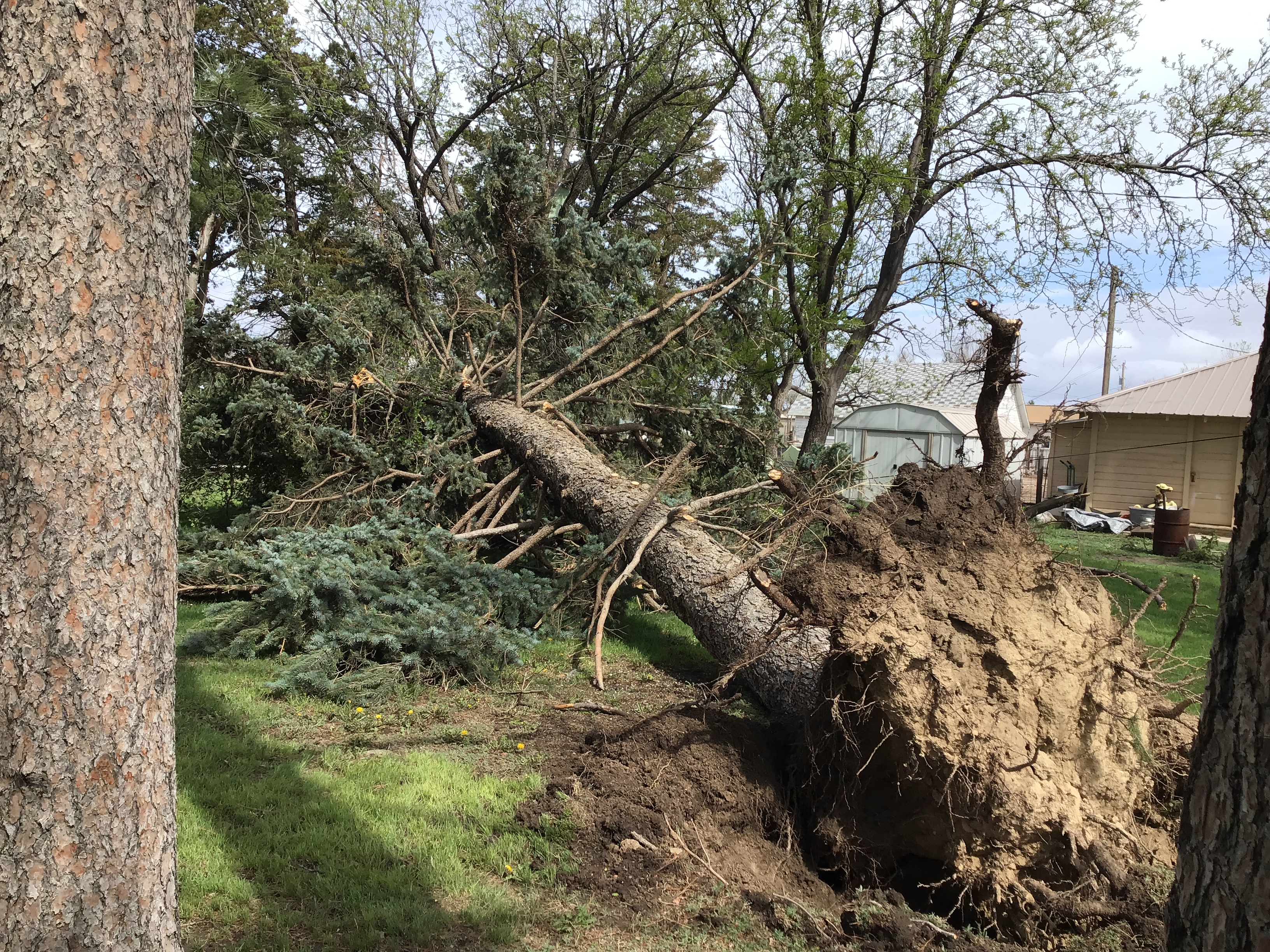
Weskan Tornado - Blue Spruce Tornado (NWS Survey) |
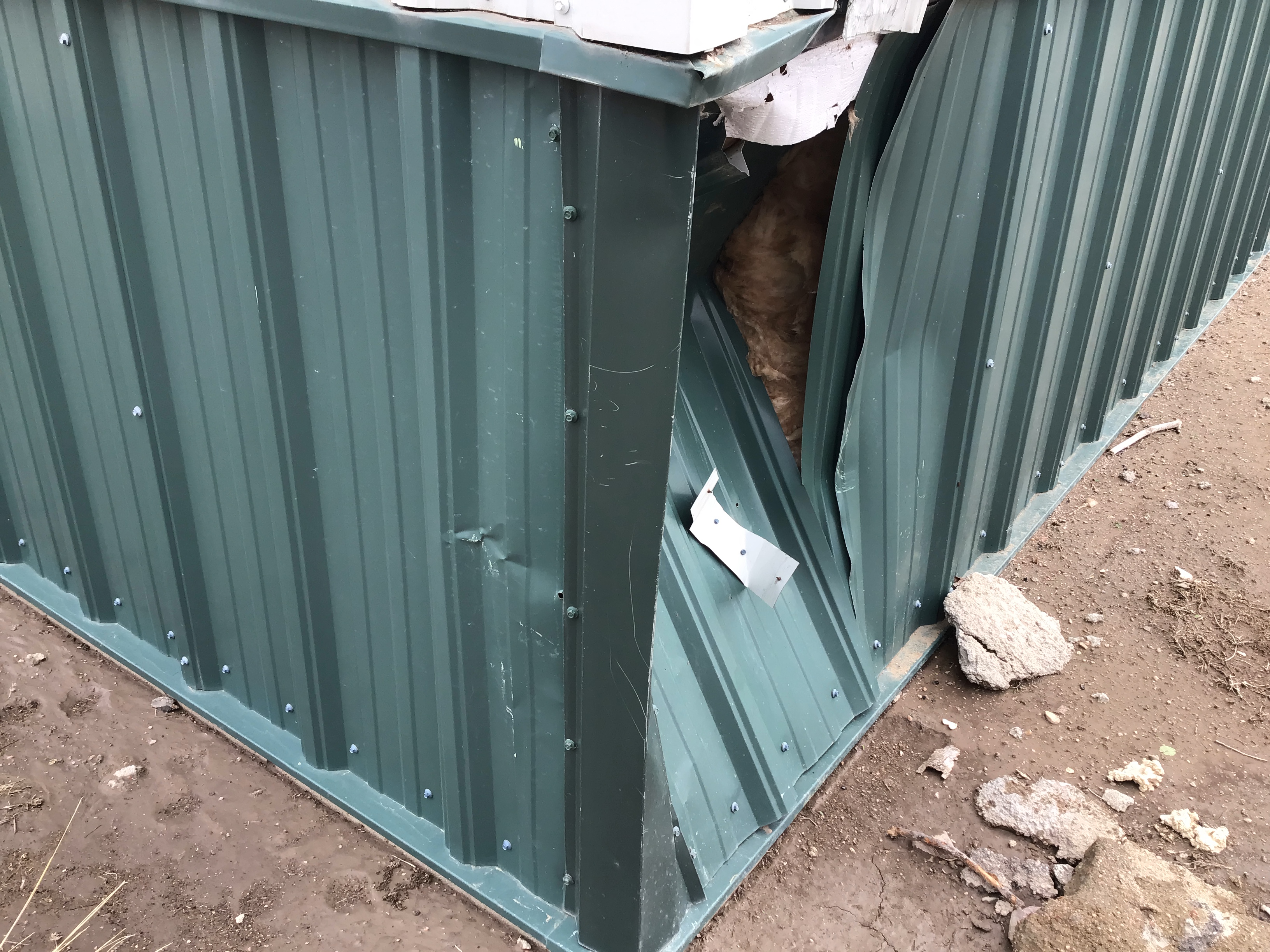
Weskan Tornado - Metal Building Dented (NWS Survey) |
Weskan Tornado - Pipes And Tubes Tossed (NWS Survey) |
 |
 |
| Two tornadoes south of Weskan, Kansas (Image Courtesy:Cameron Nixon) |
Tornado south of Weskan, Kansas (Image Courtesy:Cameron Nixon) |
Additional Images from the May 11th, 2023 Tornado Outbreak
 |
 |
 |
| Tornado near Arapahoe, CO (Image Courtesy: David Baxter) |
Tornado near Arapahoe, CO (Image Courtesy: Jake Thompson) |
Tornado near Arapahoe, CO (Image Courtesy: Travis Farncombe) |
 |
 |
| Tornado in northern Wallace County (Image Courtesy: Cheyenne Stegman) |
Damage Caused by a Tornado (Image Courtesy: Eric Young) |
 |
 |
 |
| Tornado in northwestern Logan County (Image Courtesy: Terrence Cook) |
Tornado in northwestern Logan County (Image Courtesy: Terrence Cook) |
Tornado in northwestern Logan County (Image Courtesy: Terrence Cook) |
 |
 |
| Tornado in Thomas County (Image Courtesy: Dorion Antares) |
Tornado in Thomas County (Image Courtesy: Jake Thompson) |
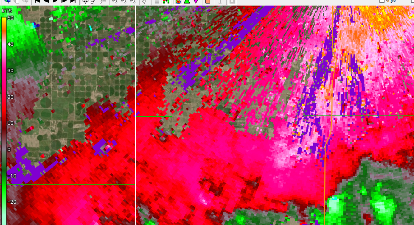
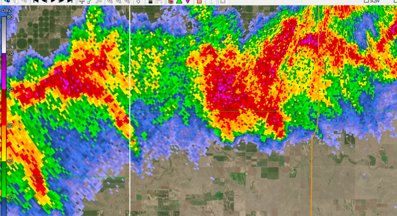
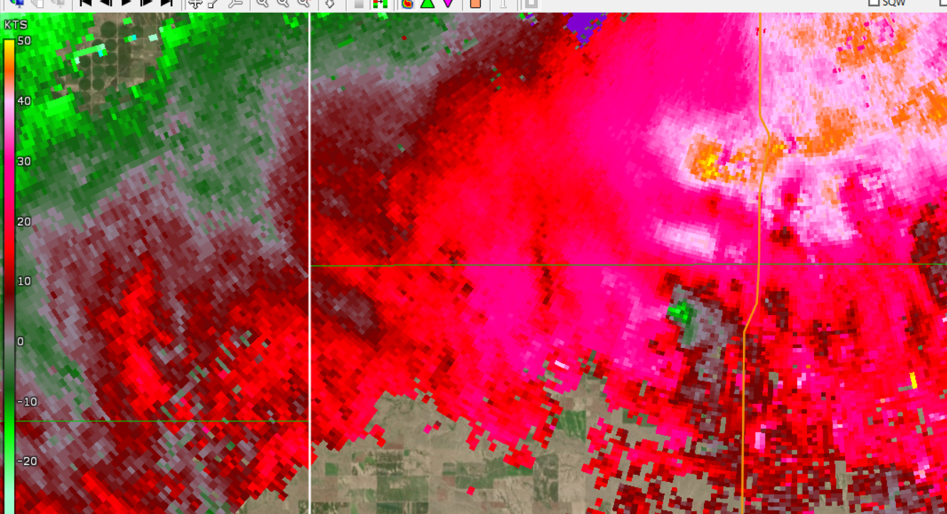
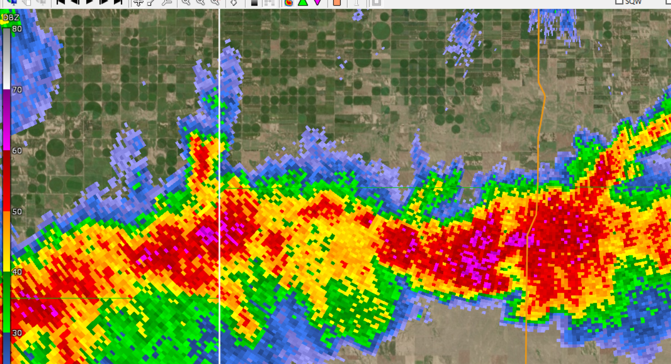
Radar
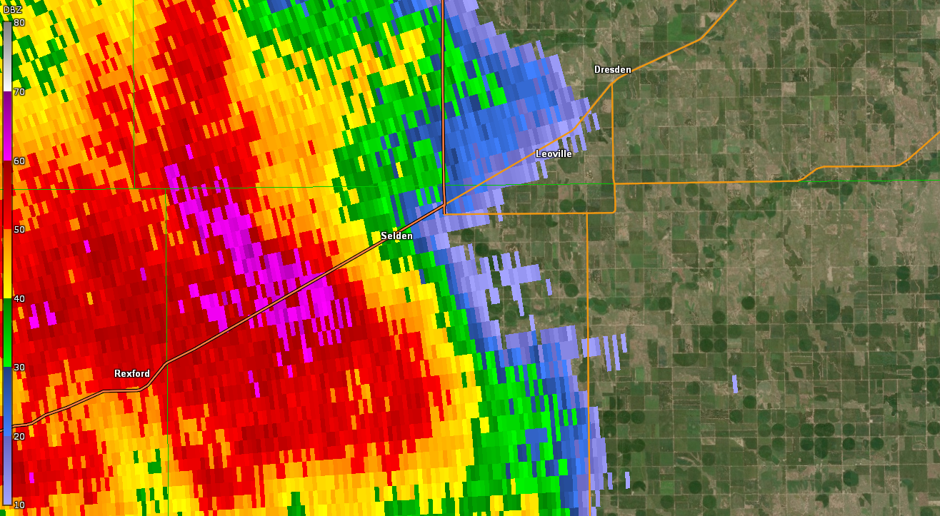
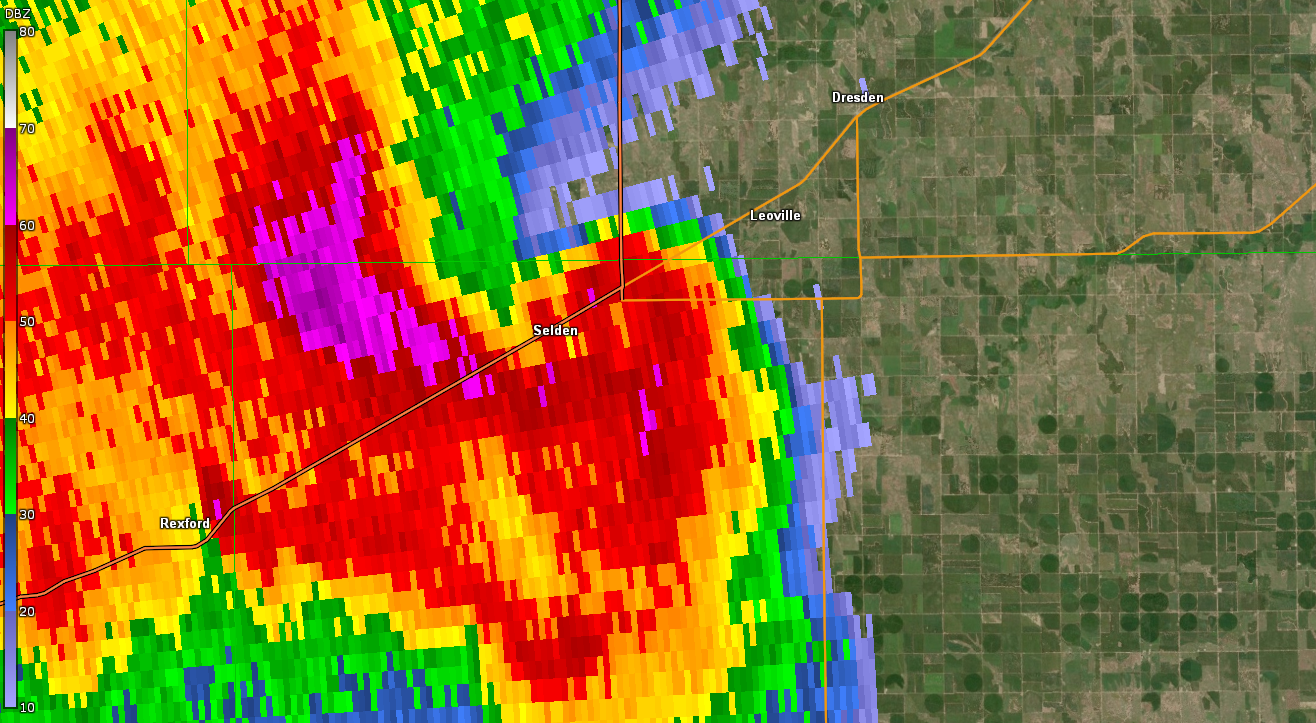
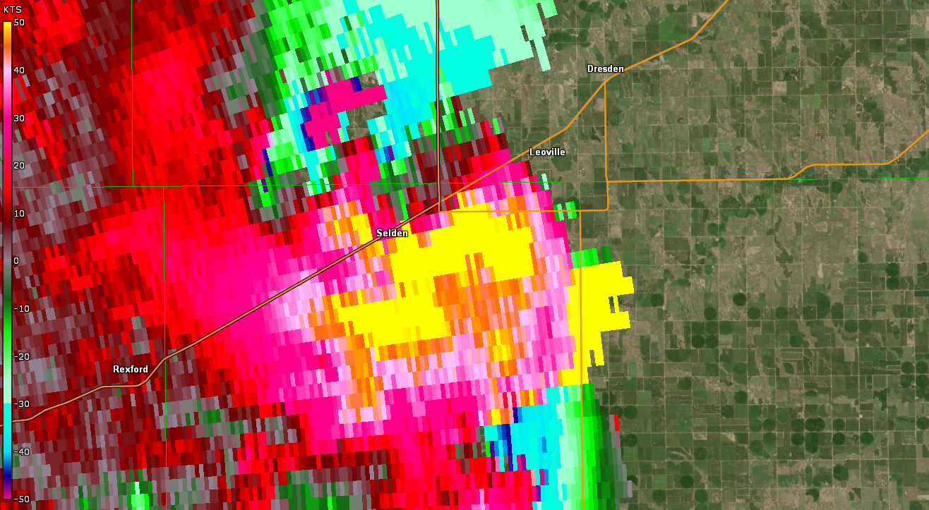
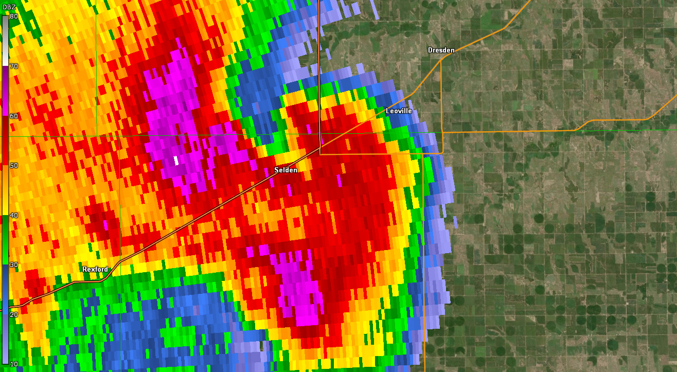
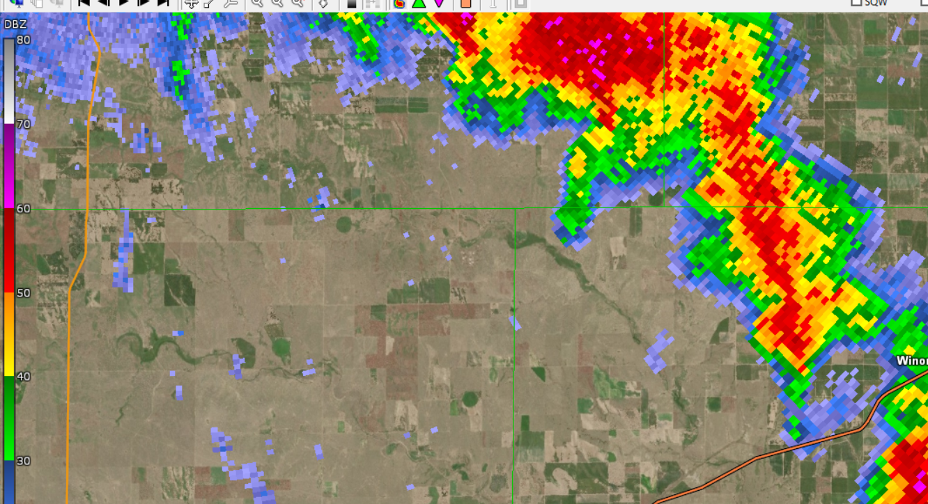
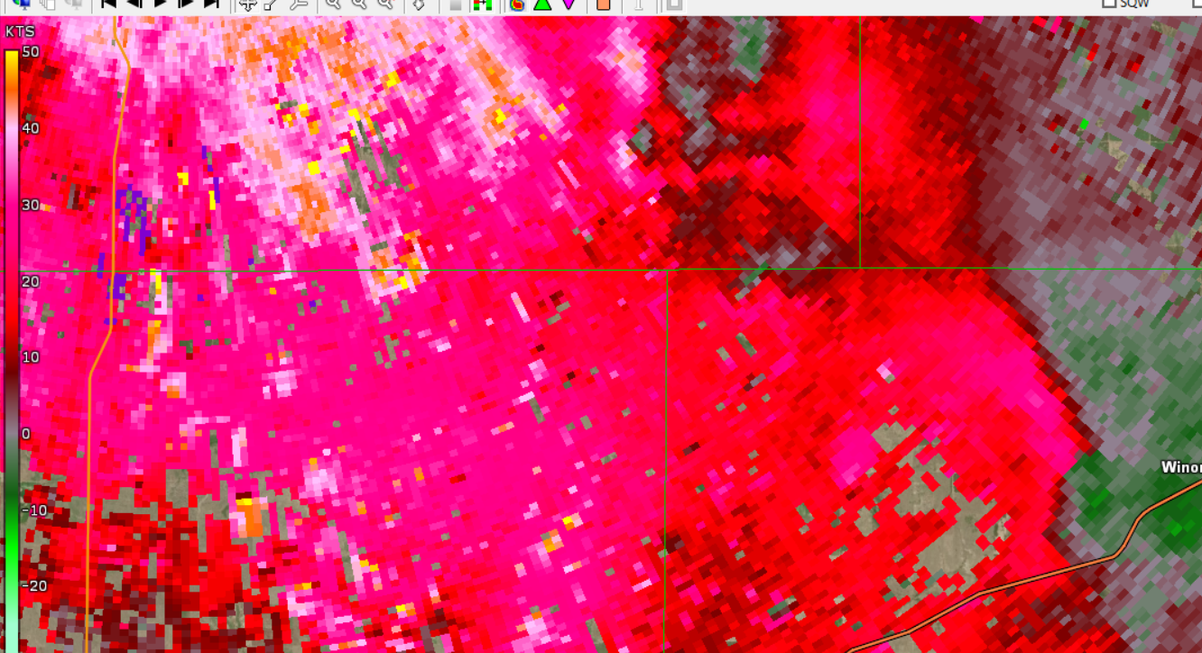
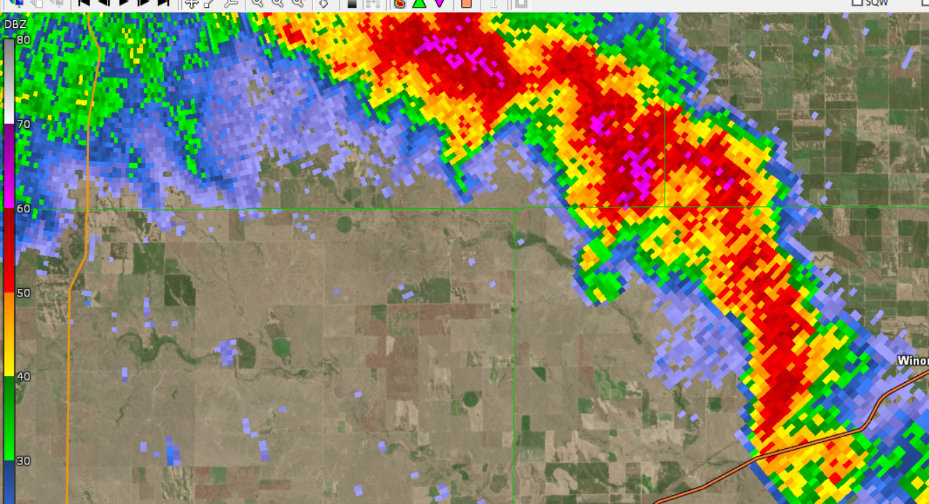
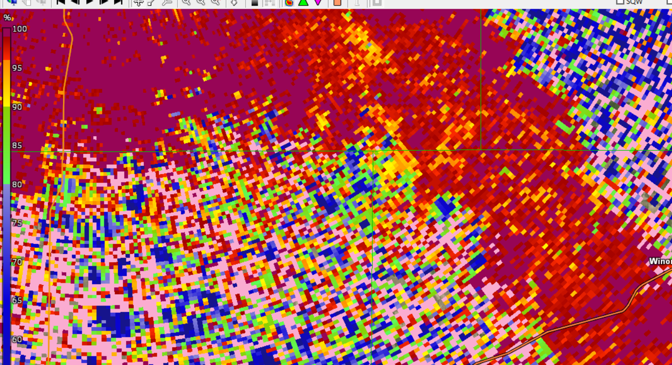
May 10th, 2023 Radar Imagery for a tornado and wind damage near Selden, Kansas
 |
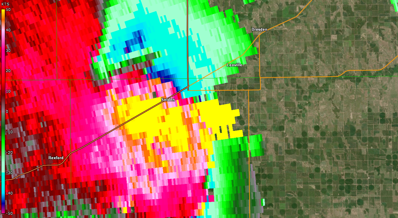 |
| A storm impacting Selden, Kansas in northwestern Sheridan County. This storm was producing straight line winds just east of town, reaching speeds of around 90 mph. Reflectivity, 5:20 pm CDT. | A storm impacting Selden, Kansas in northwestern Sheridan County. This storm was producing straight line winds just east of town, reaching speeds of around 90 mph. Velocity, 5:20 pm CDT. |
 |
 |
 |
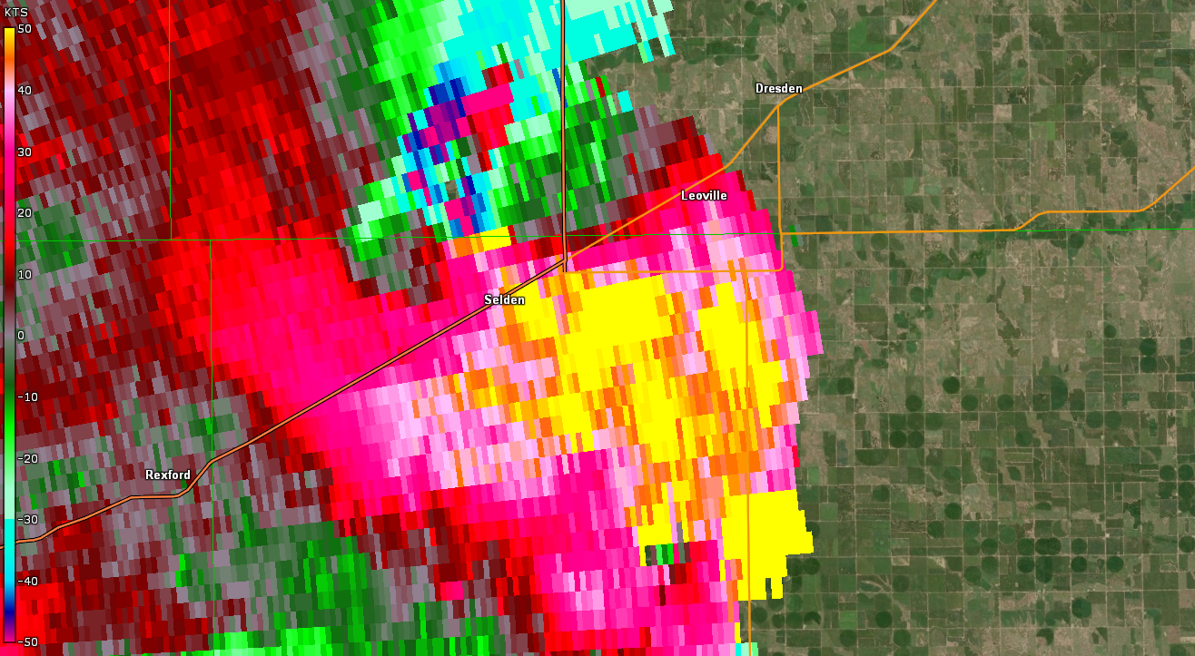 |
| Beginning of a tornado northwest of Selden, Kansas along the Sheridan/Decatur County line in NW Sheridan County. Reflectivity, 5:26 pm CDT. | Beginning of a tornado northwest of Selden, Kansas along the Sheridan/Decatur County line in NW Sheridan County. Velocity, 5:26 pm CDT. | Ending of a tornado northwest of Selden, Kansas along the Sheridan/Decatur County line in NW Sheridan County. Reflectivity, 5:30 pm CDT. | Ending of a tornado northwest of Selden, Kansas along the Sheridan/Decatur County line in NW Sheridan County. Velocity, 5:30 pm CDT. |
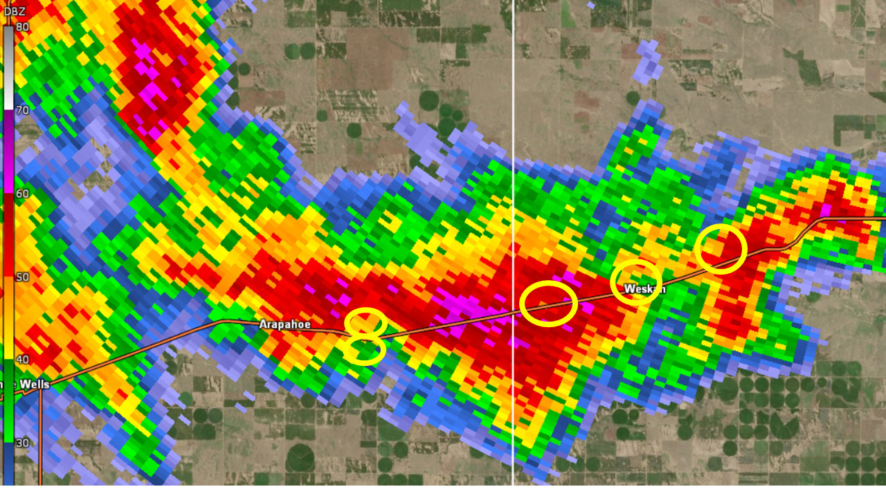
May 11th, 2023 Radar Imagery for the tornado outbreak
 |
 |
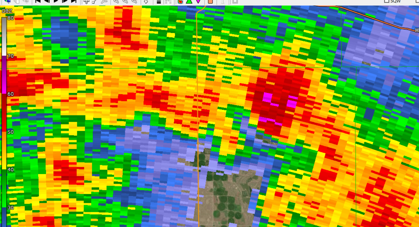
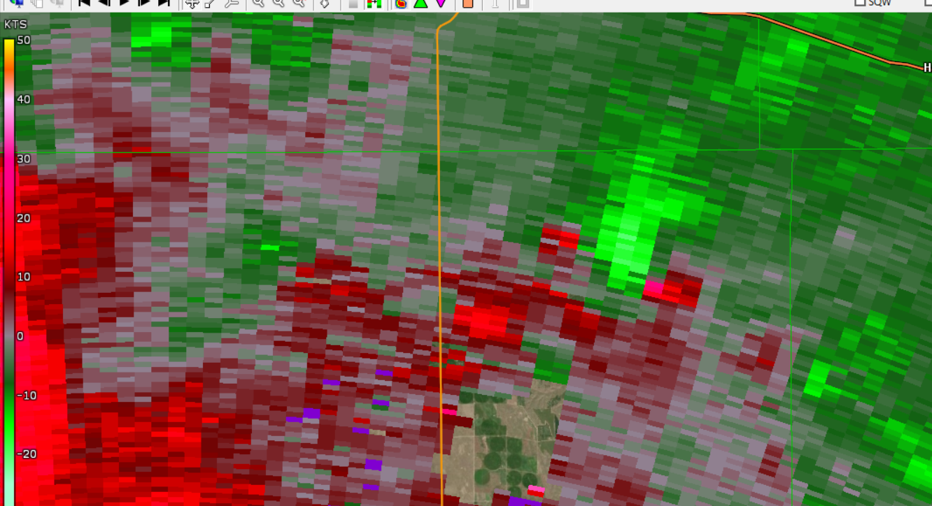
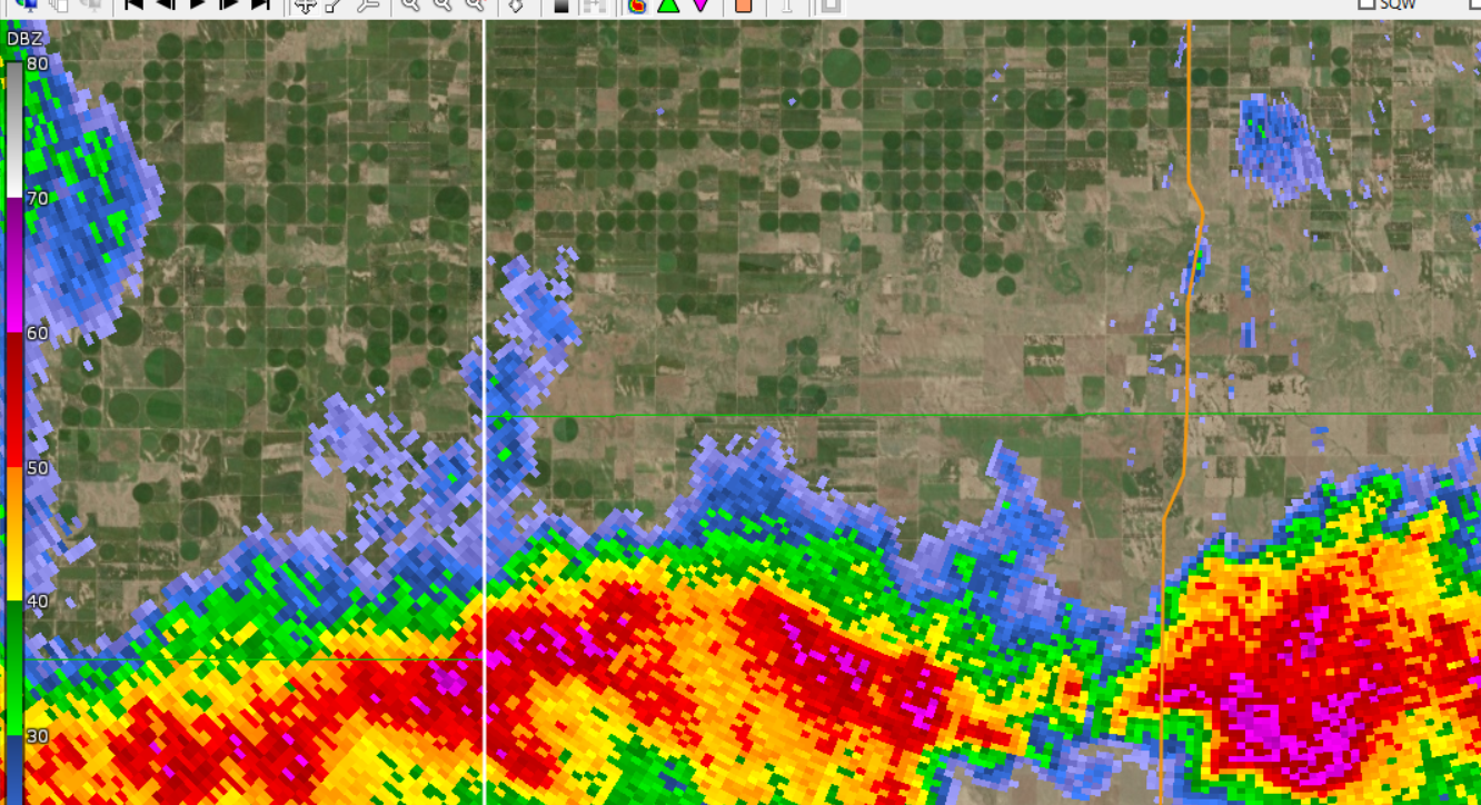
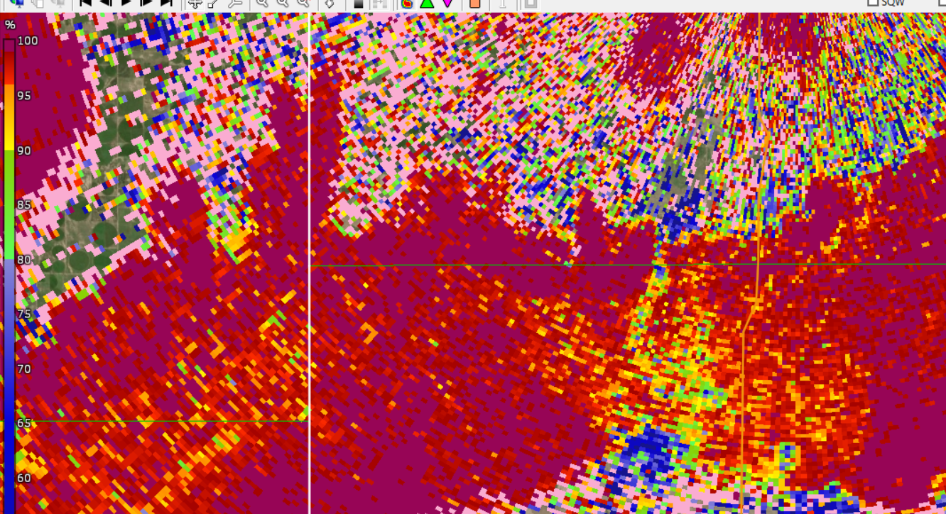
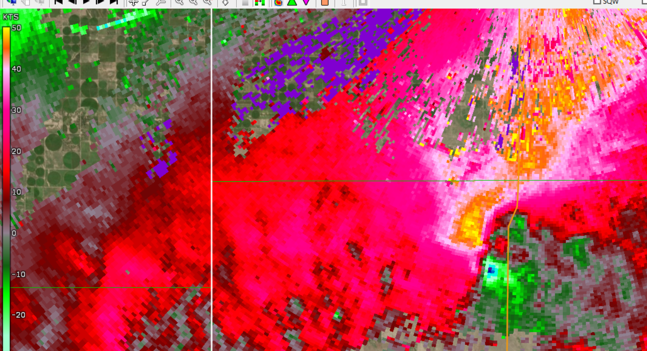
| FIVE tornadoes ongoing simultaneously within a line of storms along the Kansas/Colorado state line, impacting Cheyenne County Colorado and Wallace County Kansas. Reflectivity, 4:47 pm MDT. | FIVE tornadoes ongoing simultaneously within a line of storms along the Kansas/Colorado state line, impacting Cheyenne County Colorado and Wallace County Kansas. Storm Relative Velocity, 4:47 pm MDT. |
 |
 |
 |
 |
| Beginning of a tornado in SW Cheyenne County, Kansas. Reflectivity, 11:57 am MDT. | Beginning of a tornado in SW Cheyenne County, Kansas. Storm Relative Velocity, 11:57 am MDT. | Ending of a tornado in SE Yuma County, Colorado. Reflectivity, 12:03 pm MDT. | Ending of a tornado in SE Yuma County, Colorado. Storm Relative Velocity, 12:03 pm MDT. |
 |
 |
 |
| Tornado crossing the Kansas/Colorado State Line. Debris noted on radar imagery. Reflectivity, 11:59 am MDT. | Tornado crossing the Kansas/Colorado State Line. Debris noted on radar imagery. Correlation Coefficent, 11:59 am MDT. | Tornado crossing the Kansas/Colorado State Line. Debris noted on radar imagery. Storm Relative Velocity, 11:59 am MDT. |
 |
 |
 |
 |
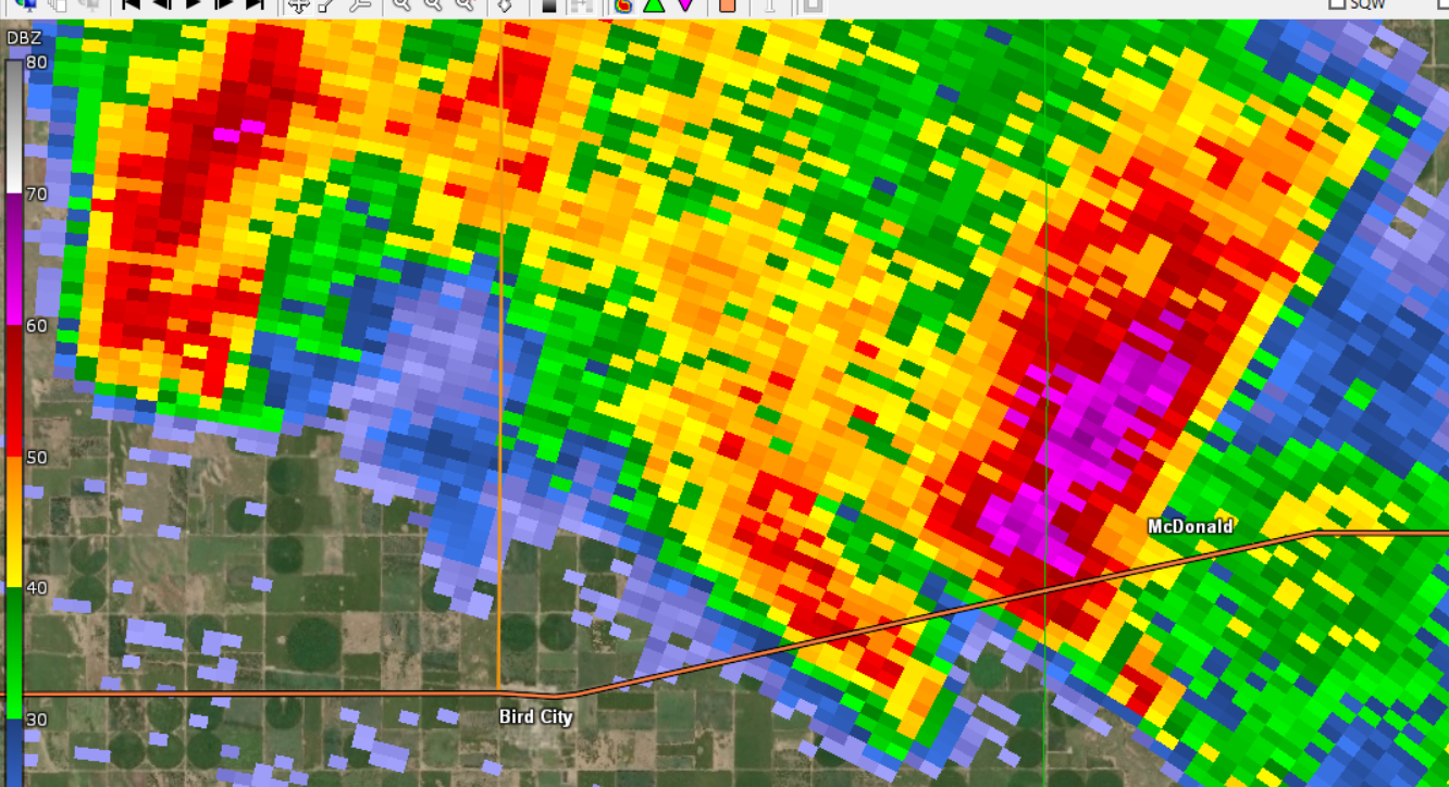
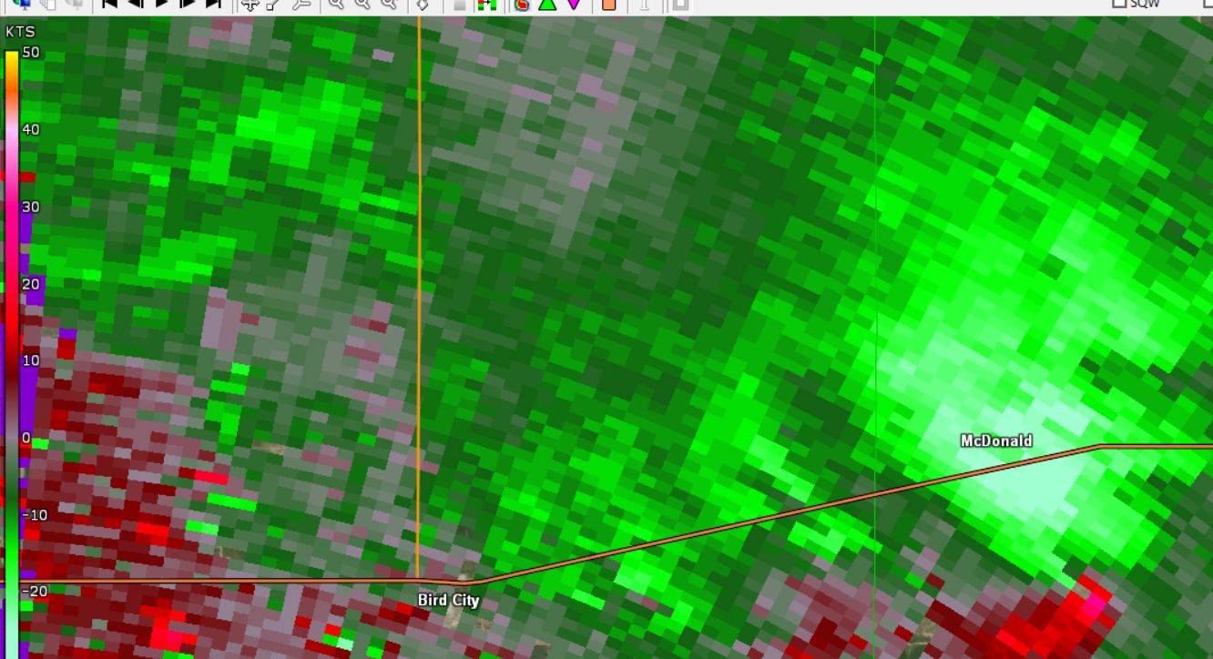
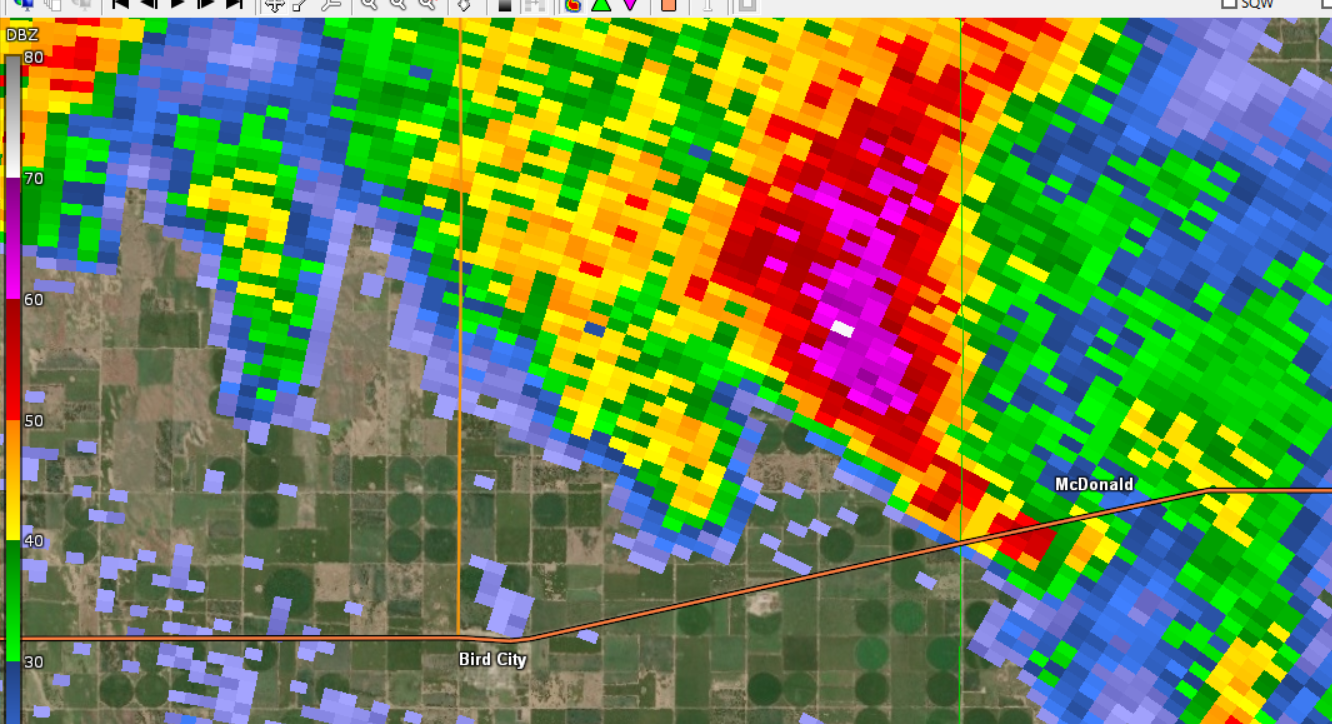
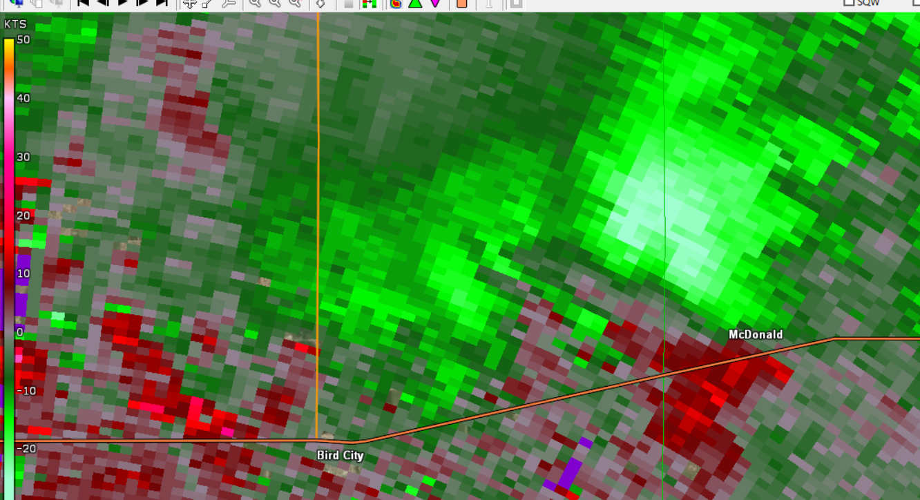
| Beginning of a tornado south of McDonald, Kansas in Rawlins County. Reflectivity, 1:35 pm CDT. | Beginning of a tornado south of McDonald, Kansas in Rawlins County. Storm Relative Velocity, 1:35 pm CDT. | Ending of a tornado south of McDonald, Kansas in Rawlins County. Reflectivity, 1:37 pm CDT. | Ending of a tornado south of McDonald, Kansas in Rawlins County. Storm Relative Velocity, 1:37 pm CDT. |
 |
 |
 |
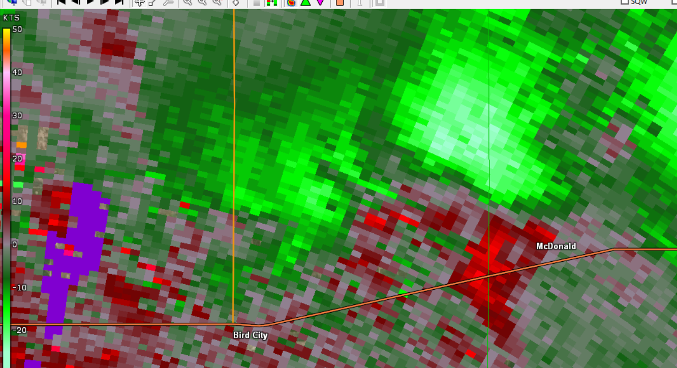 |
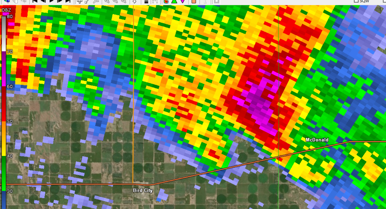
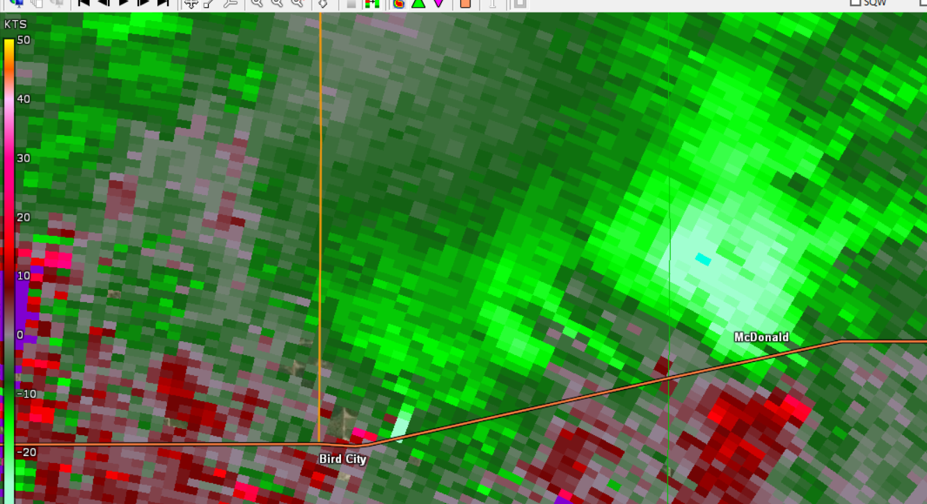
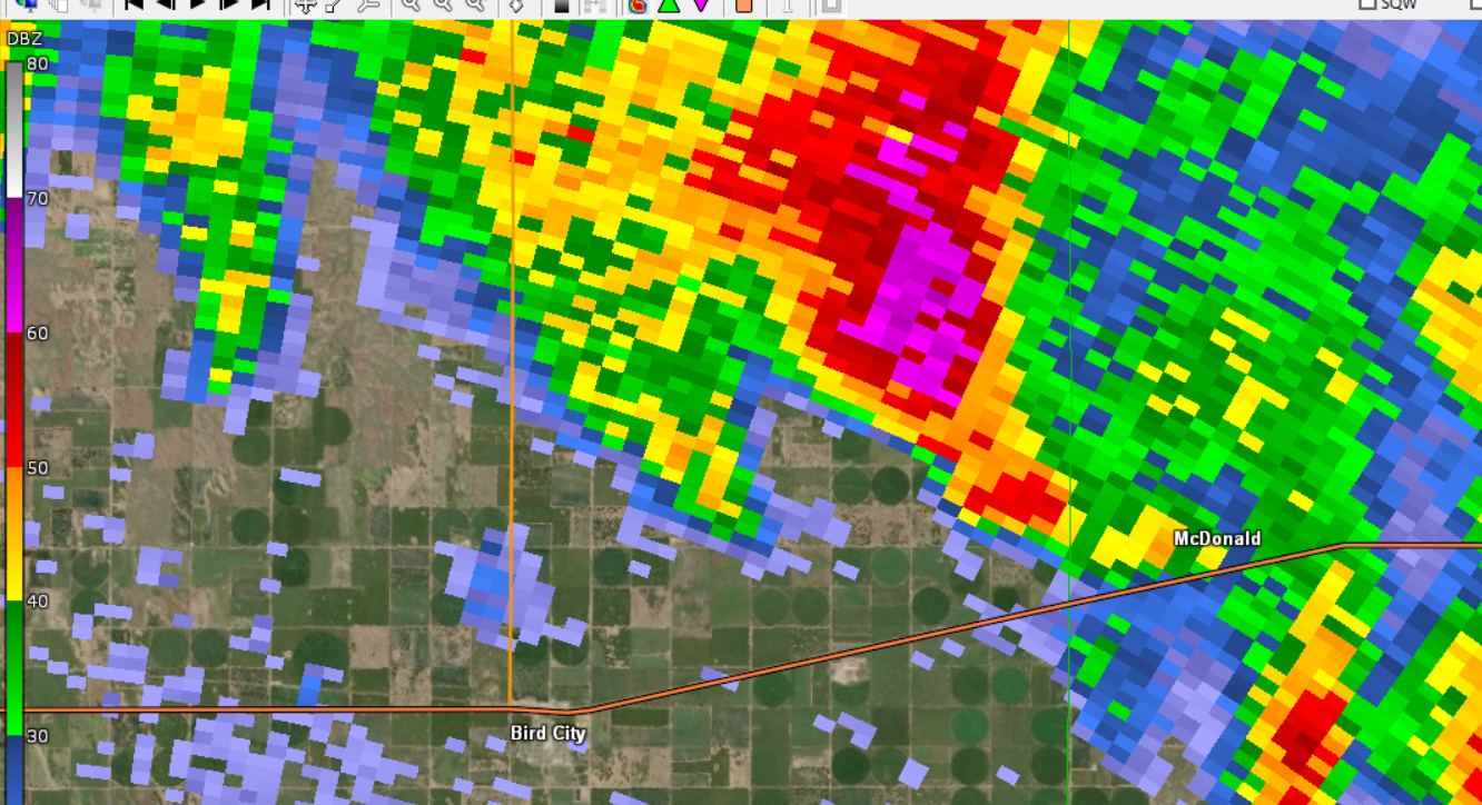
| Beginning of a second tornado just southwest of McDonald, Kansas in Rawlins County. Reflectivity, 1:40 pm CDT. | Beginning of a second tornado just southwest of McDonald, Kansas in Rawlins County. Storm Relative Velocity, 1:40 pm CDT. | Ending of a second tornado just southwest of McDonald, Kansas in Rawlins County. Reflectivity, 1:42 pm CDT. | Ending of a second tornado just southwest of McDonald, Kansas in Rawlins County. Storm Relative Velocity, 1:42 pm CDT. |
 |
 |
| Tornado moving across northeastern Dundy County. Reflectivity, 2:04 pm MDT. | Tornado moving across northeastern Dundy County. Storm Relative Velocity, 2:04 pm MDT. |
 |
 |
 |
| Tornado begins south-southwest of Sharon Springs, Kansas in Wallace County. Reflectivity, 4:32 pm MDT. | Tornado begins south-southwest of Sharon Springs, Kansas in Wallace County. Storm Relative Velocity, 4:32 pm MDT. | Tornado continues southwest of Sharon Springs, Kansas in Wallace County. Another tornadic circulation is ongoing closer to the Colorado/Kansas border. Reflectivity, 4:40 pm MDT. |
 |
 |
 |
| Tornado continues southwest of Sharon Springs, Kansas in Wallace County. Another tornadic circulation is ongoing closer to the Colorado/Kansas border. Storm Relative Velocity, 4:40 pm MDT. | Tornado ends after crossing US Highway 40 west of Sharon Springs, Kansas in Wallace County. Reflectivity, 4:50 pm MDT. | Tornado ends after crossing US Highway 40 west of Sharon Springs, Kansas in Wallace County. Storm Relative Velocity, 4:50 pm MDT. |
 |
 |
 |
| Tornado begins along the Colorado/Kansas state line in Wallace County. Reflectivity, 4:39 pm MDT. | Tornado begins along the Colorado/Kansas state line in Wallace County. Storm Relative Velocity, 4:39 pm MDT. | Tornado continues along the Colorado/Kansas state line in Wallace County, crossing US Highway 40. Reflectivity, 4:45 pm MDT. |
 |
 |
 |
| Tornado continues along the Colorado/Kansas state line in Wallace County, crossing US Highway 40. Storm Relative Velocity, 4:45 pm MDT. | Tornado ends along the Colorado/Kansas state line in Wallace County. Reflectivity, 4:50 pm MDT. | Tornado ends along the Colorado/Kansas state line in Wallace County. Storm Relative Velocity, 4:50 pm MDT. |
 |
 |
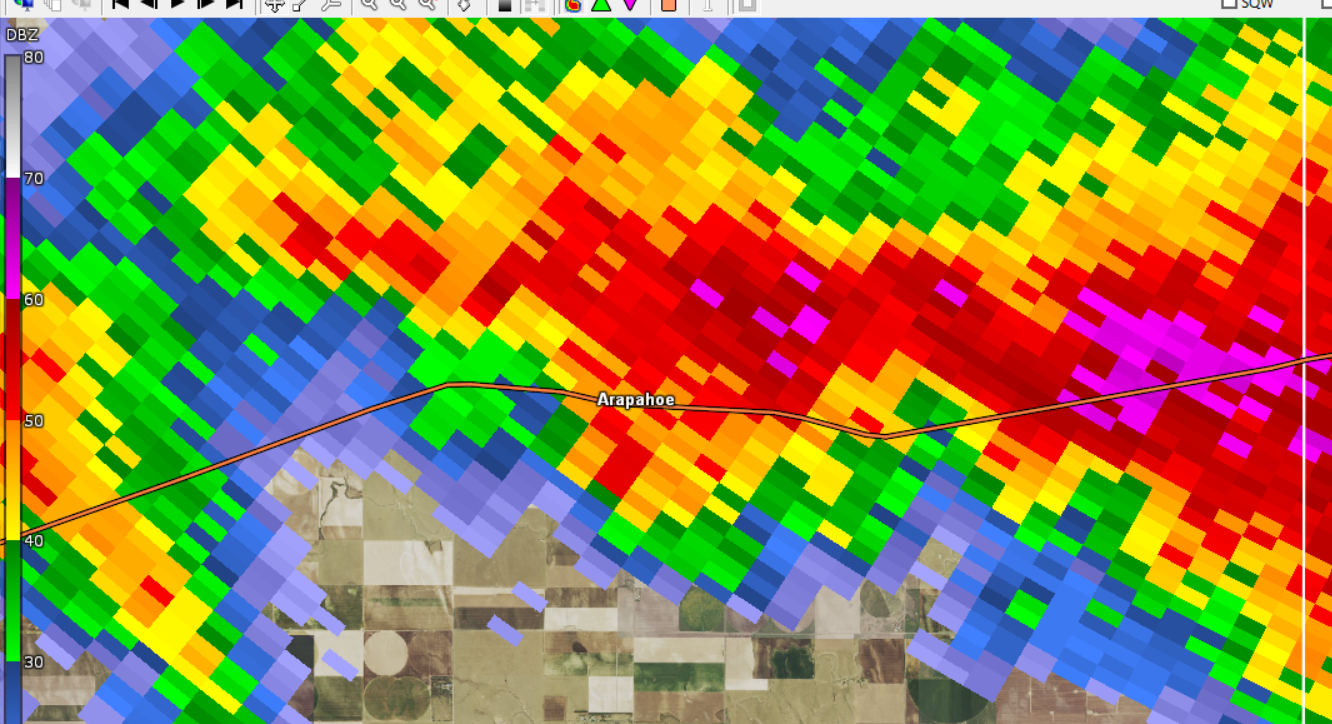 |
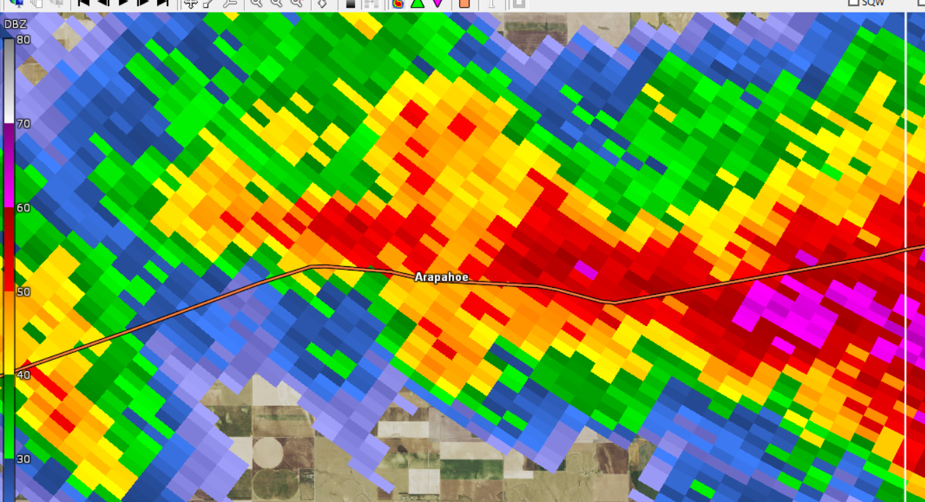
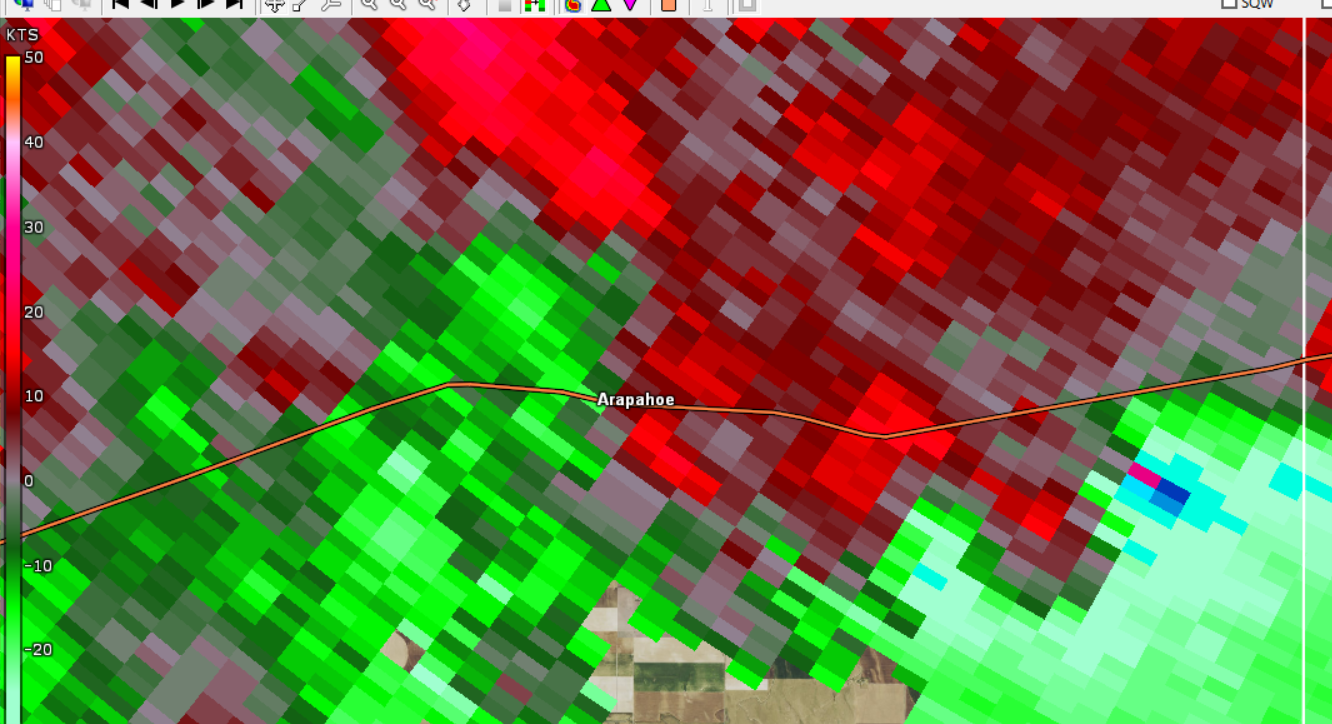
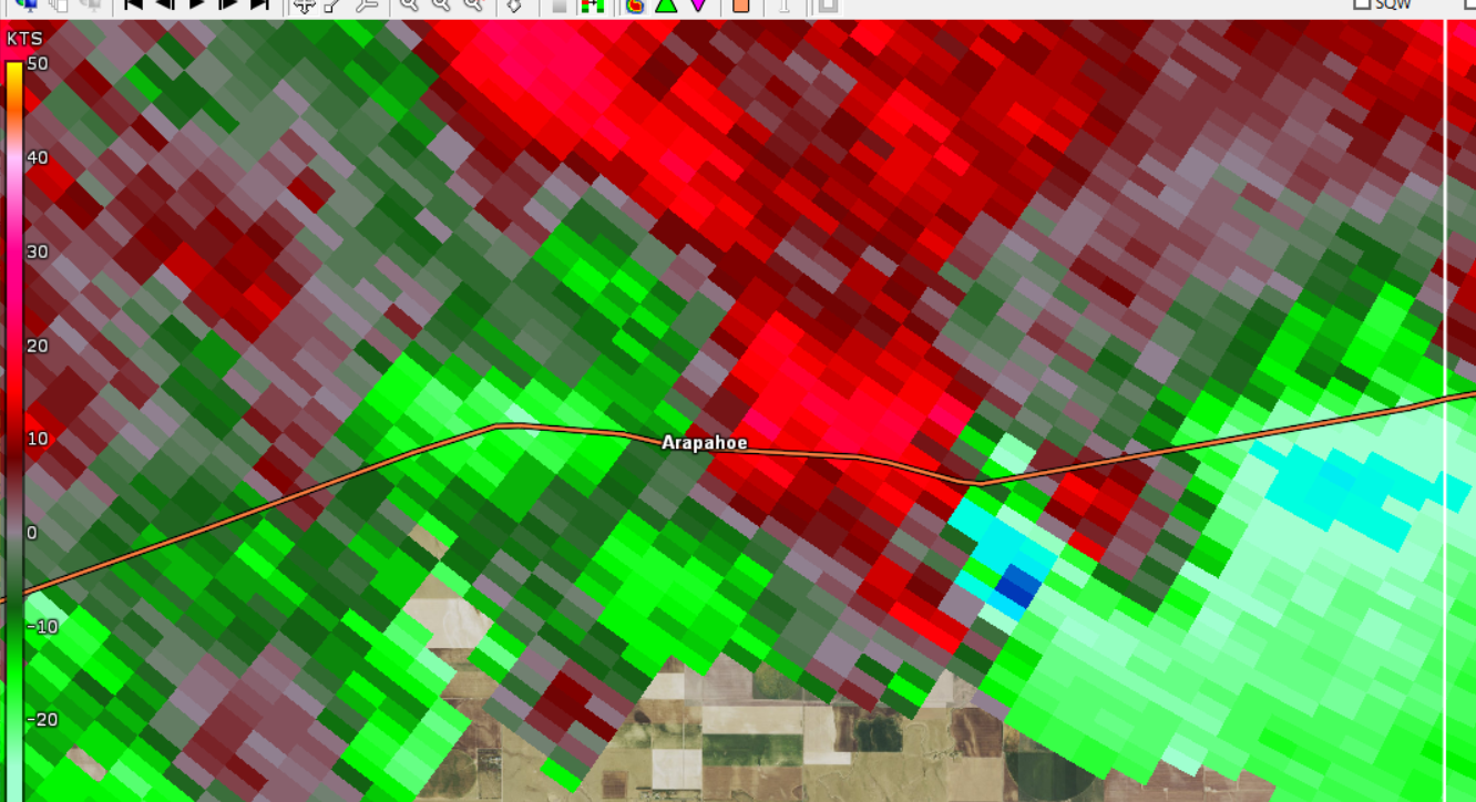
| Tornado begins southeast of Arapahoe, Colorado in Cheyenne County. Reflectivity, 4:45 pm MDT. | Tornado begins southeast of Arapahoe, Colorado in Cheyenne County. Storm Relative Velocity, 4:45 pm MDT. | A second tornado begins east of Arapahoe, Colorado in Cheyenne County. Two tornadoes ongoing simultaneously Reflectivity, 4:47 pm MDT. |
 |
 |
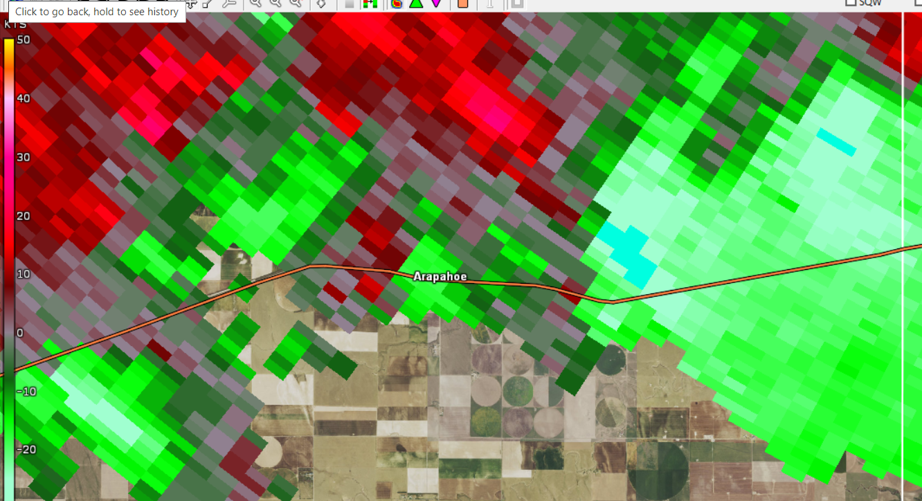 |
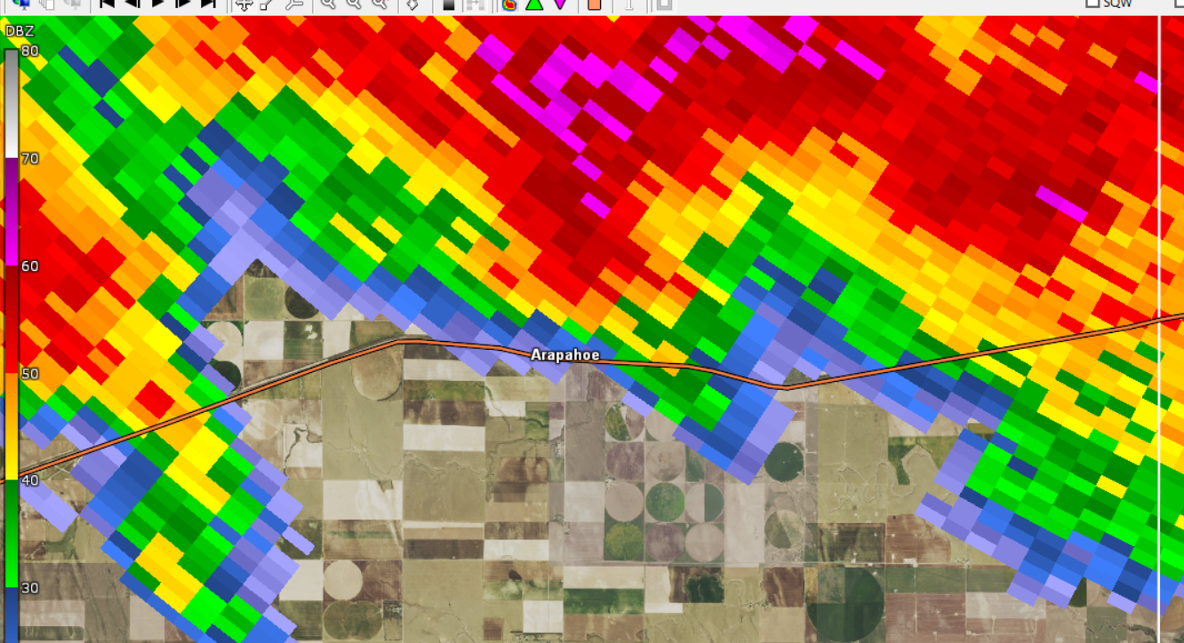
| A second tornado begins east of Arapahoe, Colorado in Cheyenne County. Two tornadoes ongoing simultaneously. Storm Relative Velocity, 4:47 pm MDT. | Both tornadoes come to an end east of Arapahoe, Colorado in Cheyenne County. Reflectivity, 4:53 pm MDT. | Both tornadoes come to an end east of Arapahoe, Colorado in Cheyenne County. Storm Relative Velocity, 4:53 pm MDT. |
 |
 |
 |
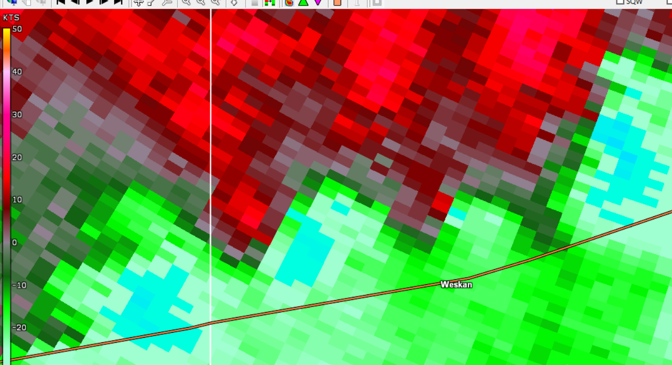 |
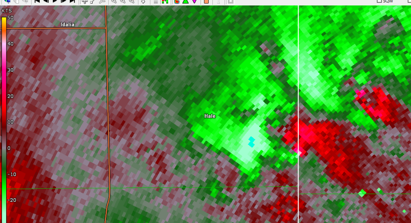
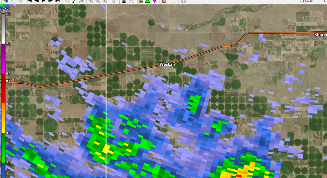
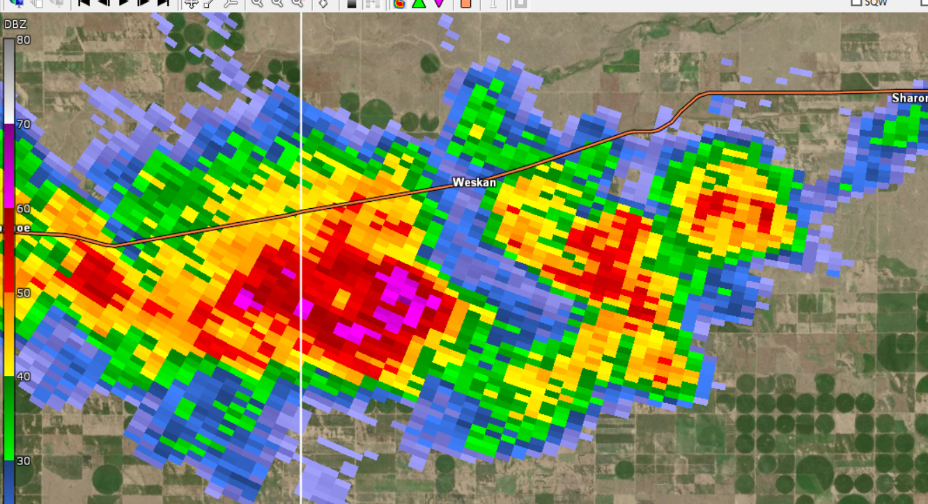
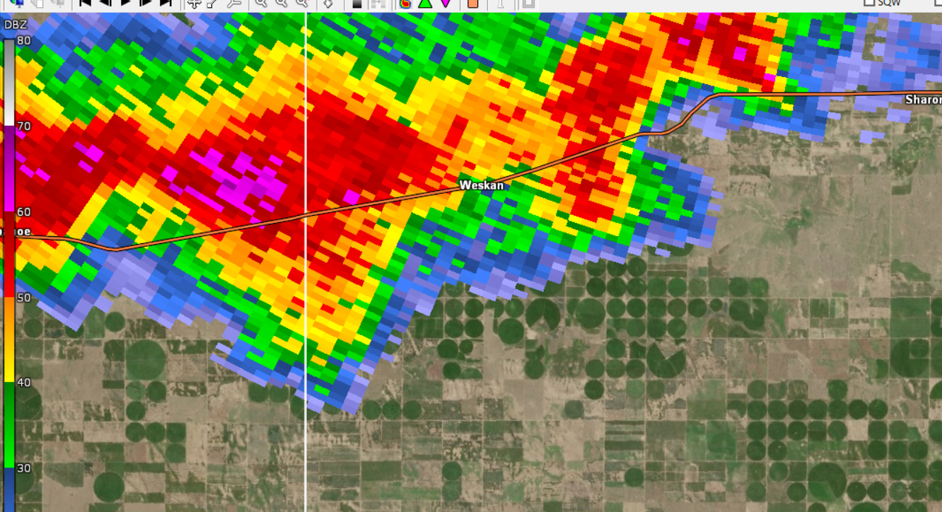
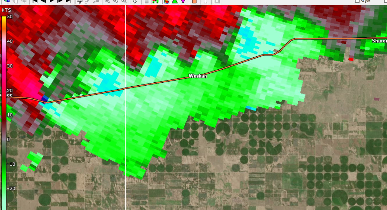
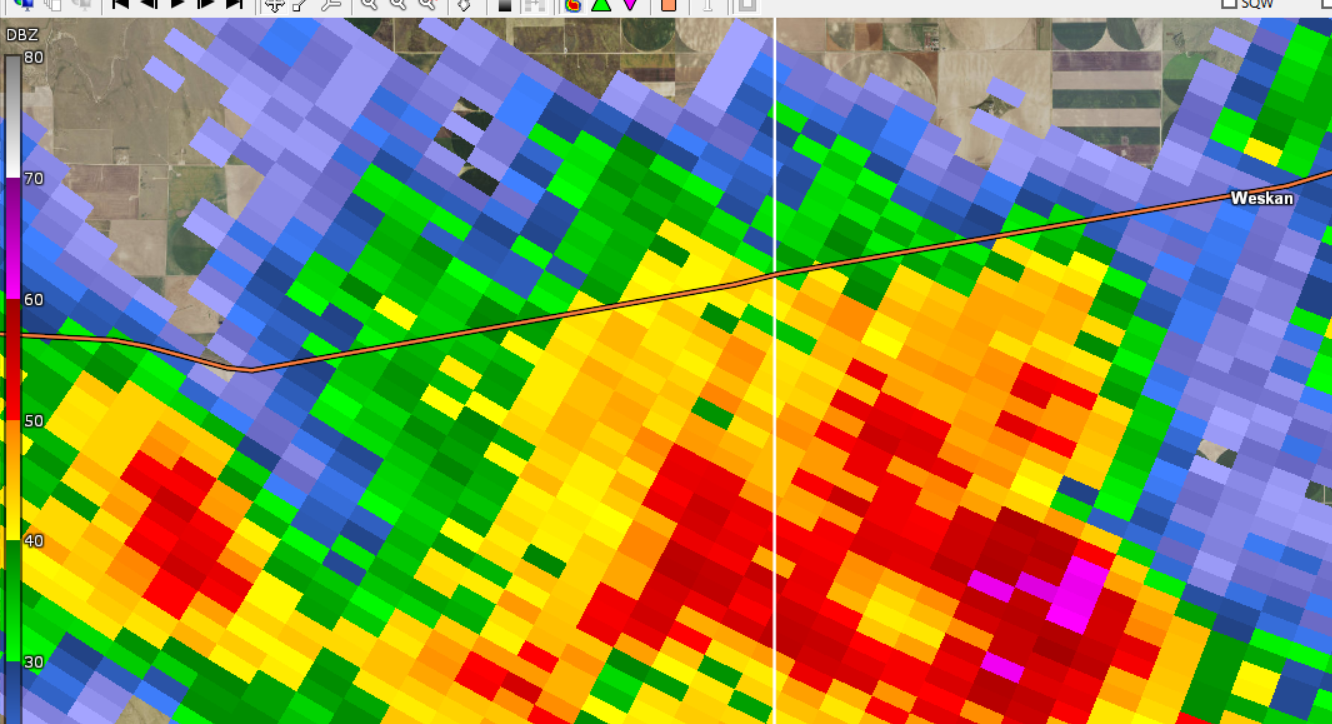
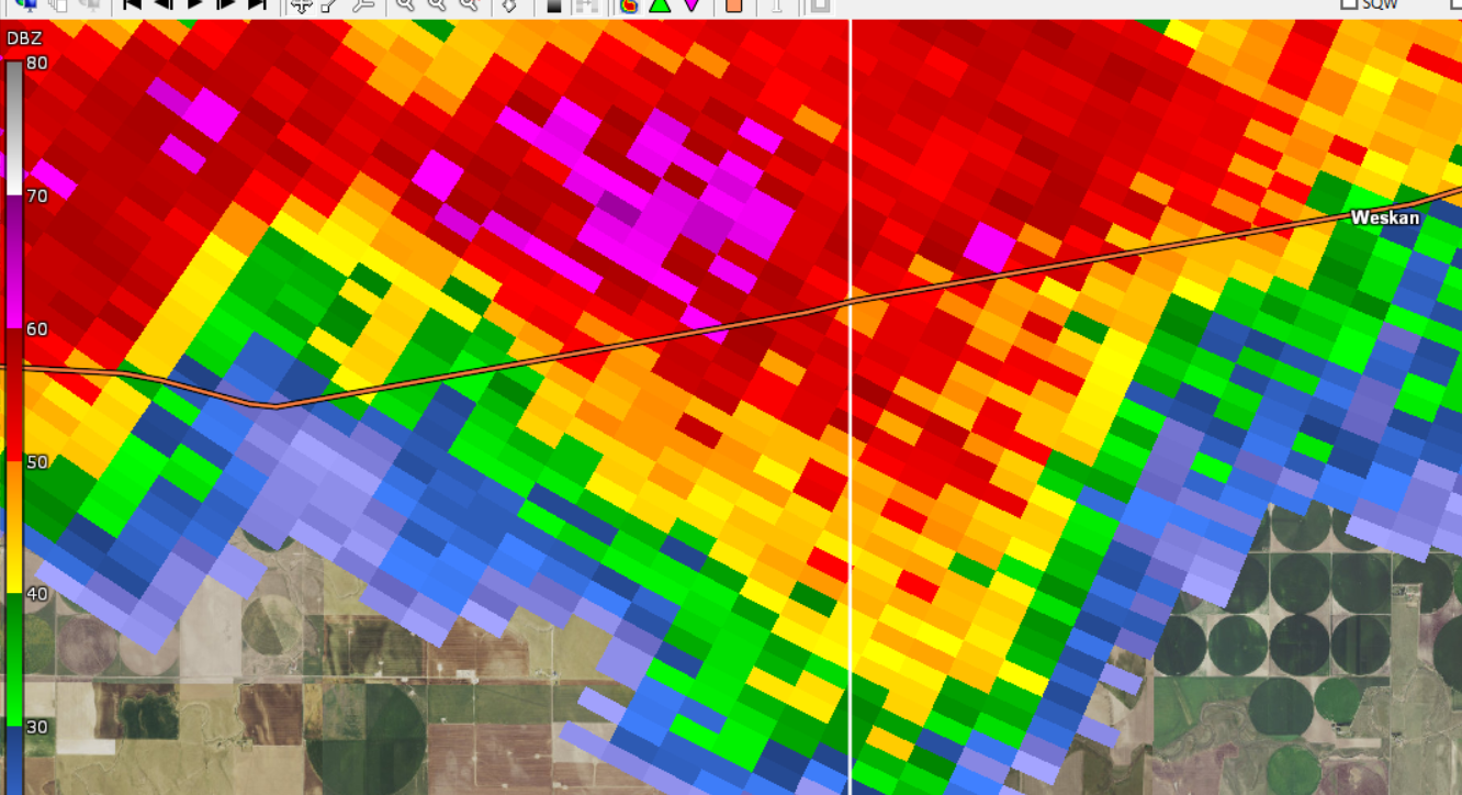
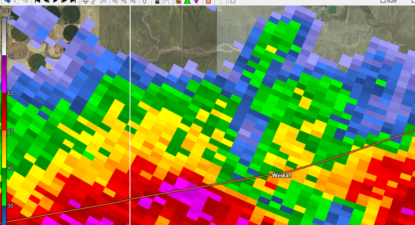
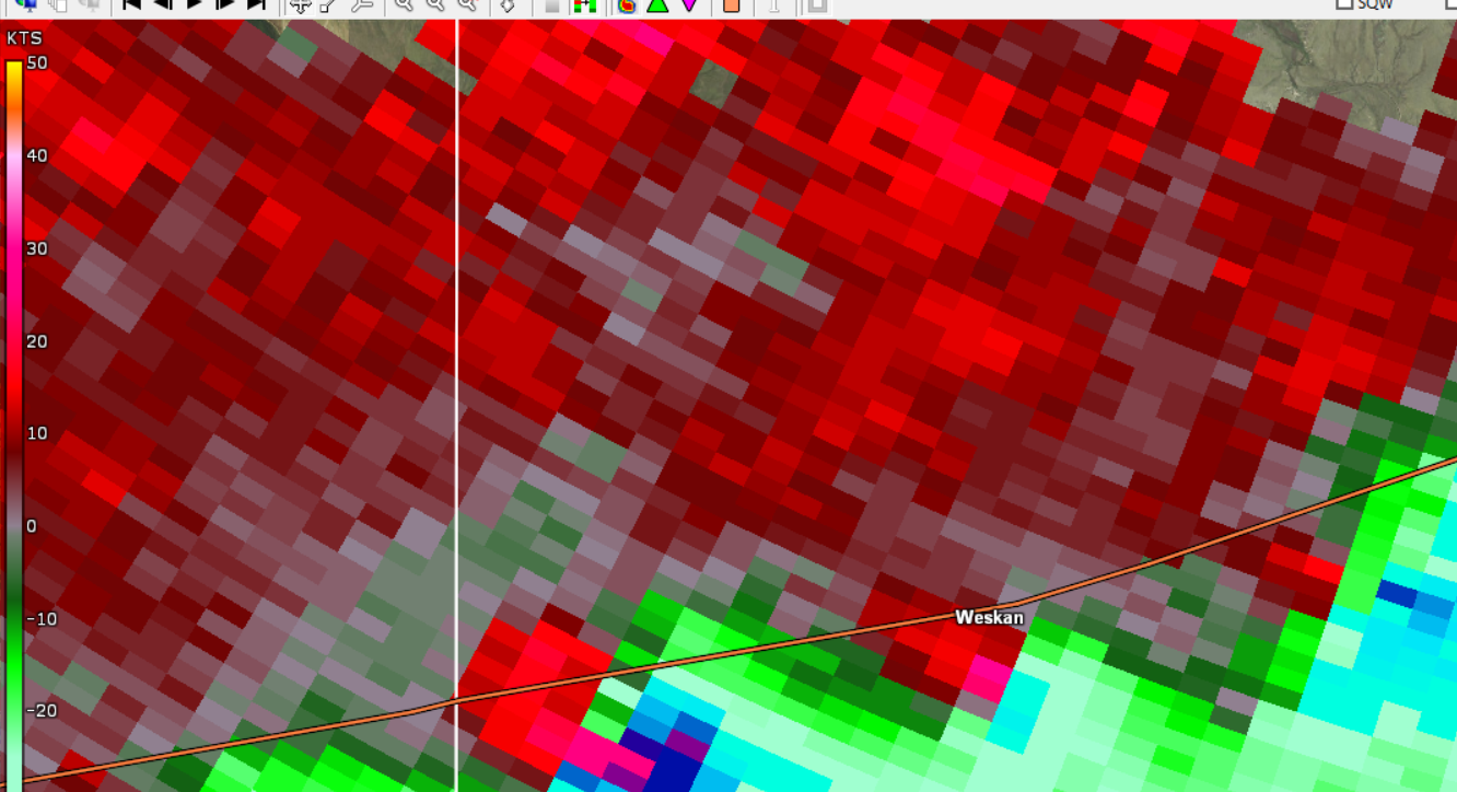
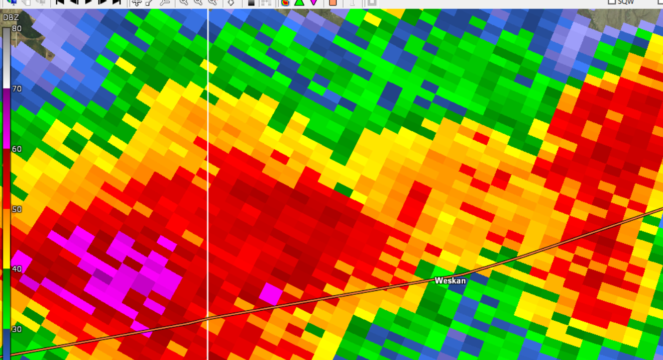
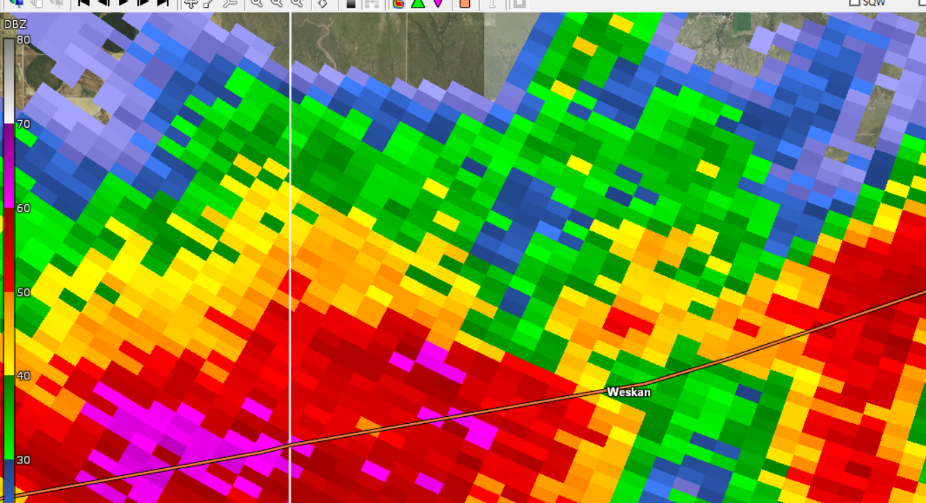
| Beginning of a tornado south of Weskan, Kansas in Wallace County. Reflectivity, 4:45 pm MDT. | Beginning of a tornado south of Weskan, Kansas in Wallace County. Storm Relative Velocity, 4:45 pm MDT. | Ending of the tornado that struck Weskan, Kansas in Wallace County. Reflectivity, 4:49 pm MDT. | Ending of the tornado that struck Weskan, Kansas in Wallace County. Storm Relative Velocity, 4:49 pm MDT. |
 |
 |
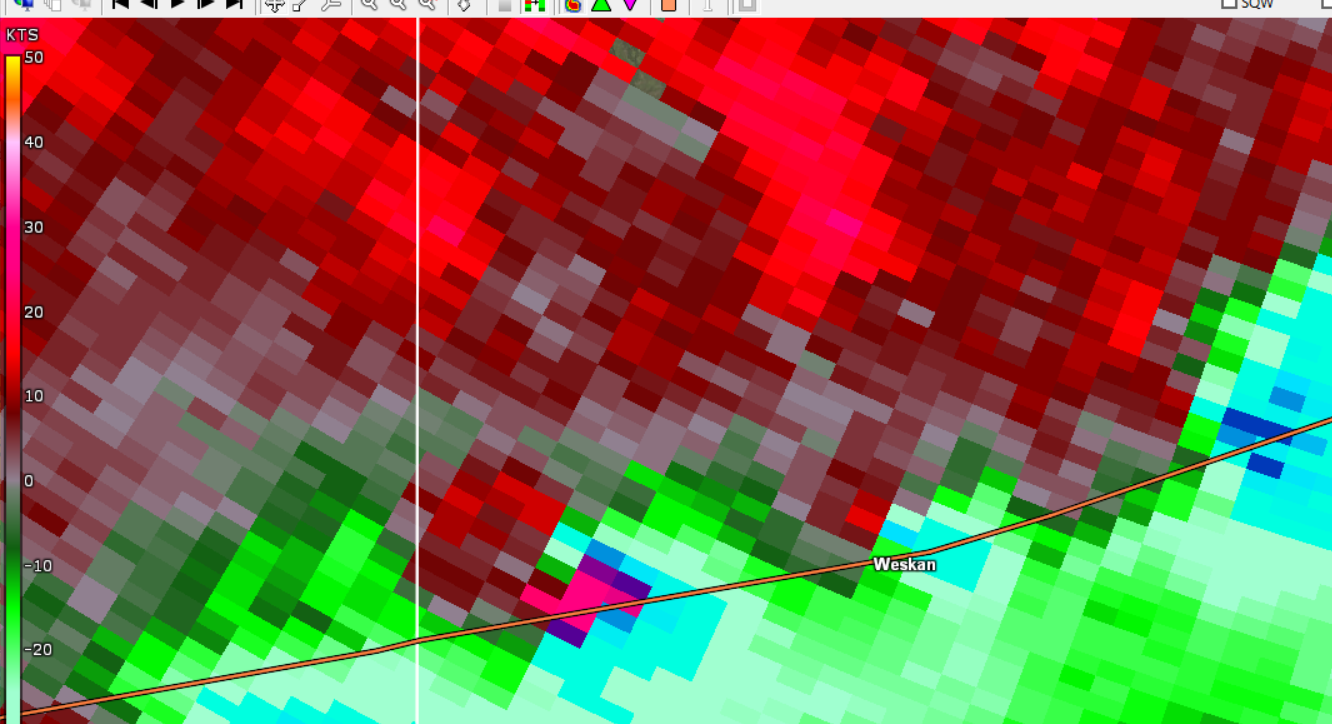 |
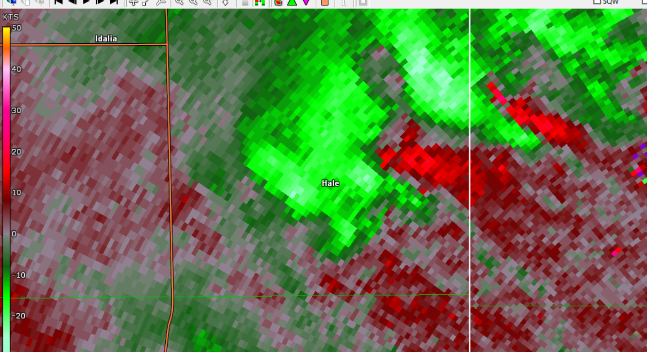
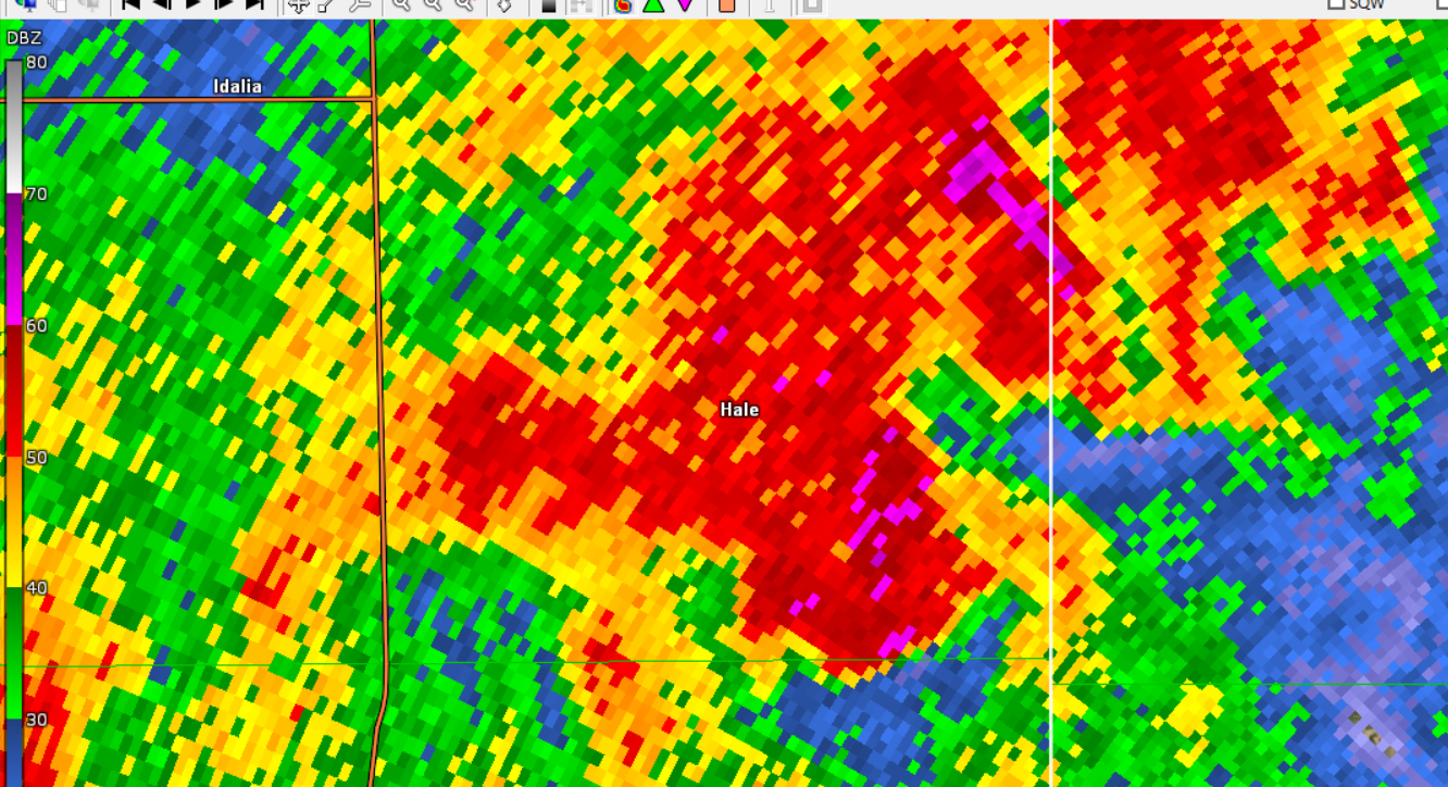
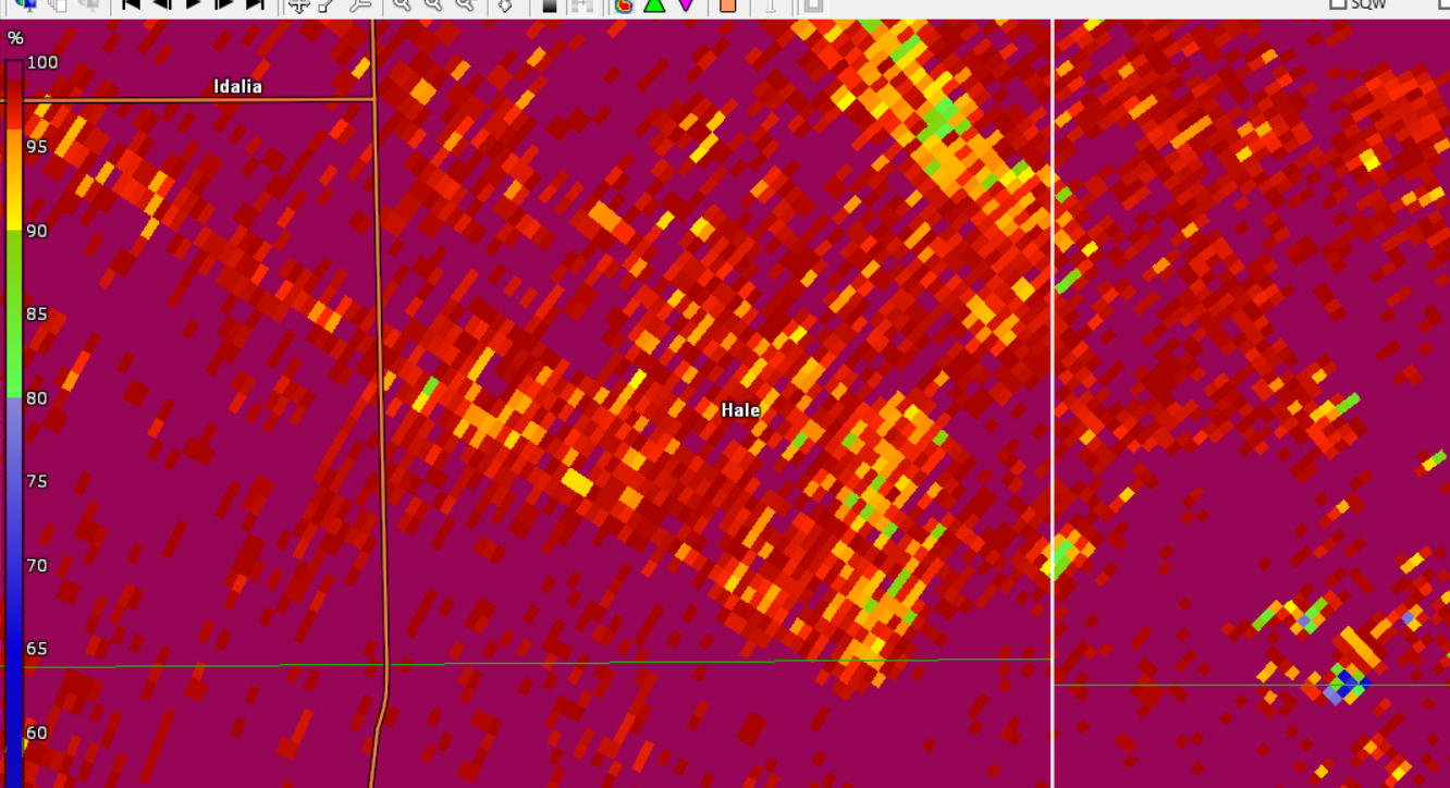
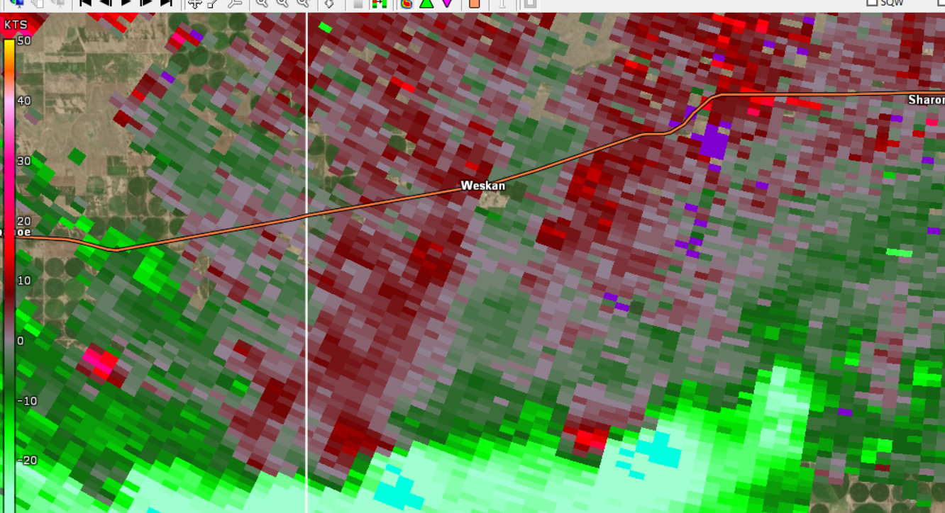
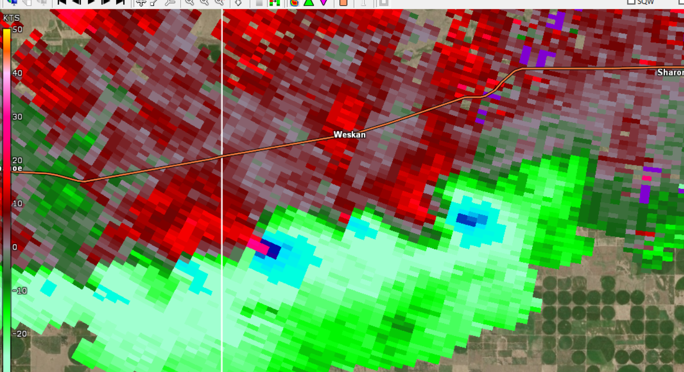
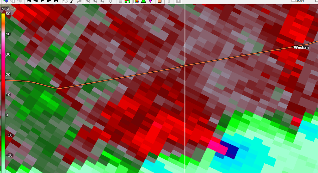
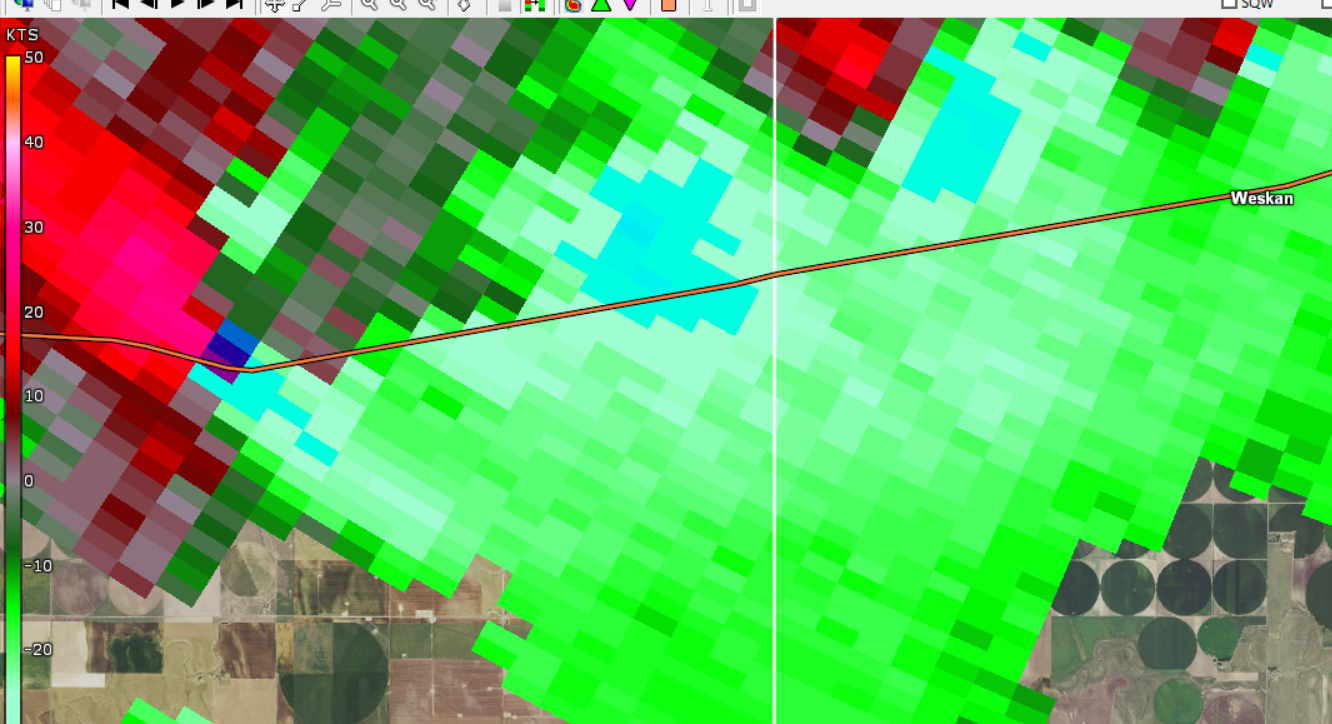
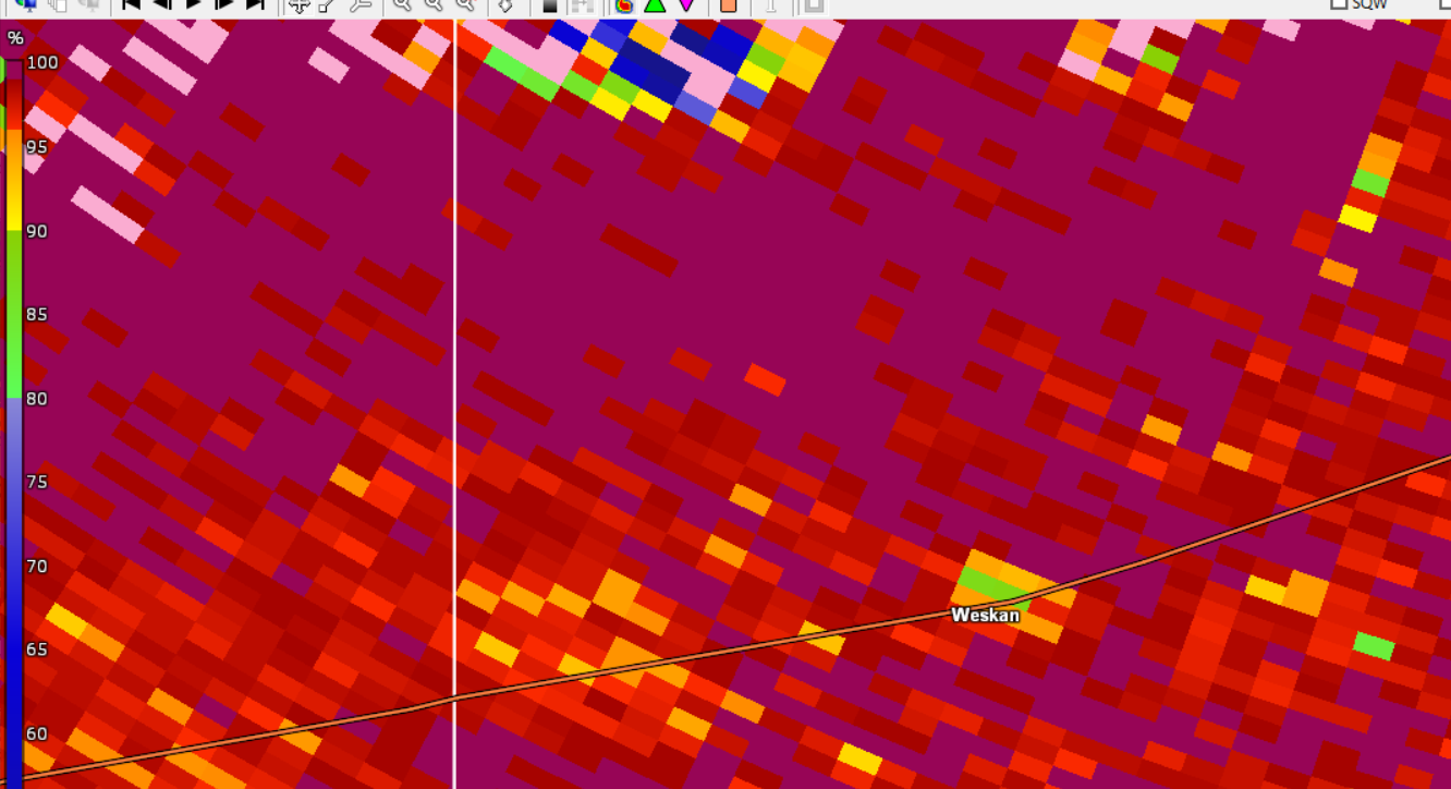
| Tornado as it strikes Weskan, Kansas in Wallace County. Reflectivity, 4:47 pm MDT. | Tornado as it strikes Weskan, Kansas in Wallace County. Tornado debris indicated on radar. Correlation Coefficient, 4:47 pm MDT. | Tornado as it strikes Weskan, Kansas in Wallace County. Tornadic circulations also noted near US Highway 40 both east and west of Weskan. Storm Relative Velocity, 4:47 pm MDT. |
 |
 |
 |
 |
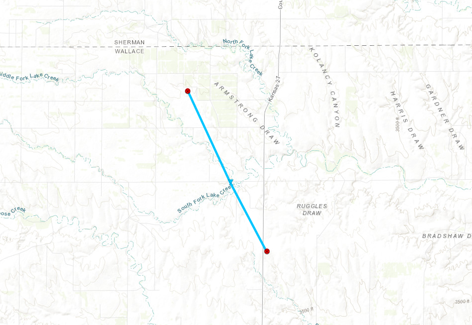
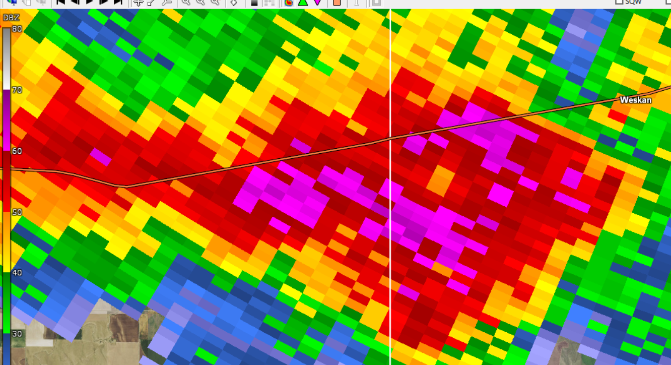
| Beginning of a tornado along Highway 27 in northern Wallace County, Kansas. Reflectivity, 5:09 pm MDT. | Beginning of a tornado along Highway 27 in northern Wallace County, Kansas. Storm Relative Velocity, 5:09 pm MDT. | Ending of a tornado in northern Wallace County, Kansas. Reflectivity, 5:29 pm MDT. | Ending of a tornado in northern Wallace County, Kansas. Storm Relative Velocity, 5:29 pm MDT. |
 |
 |
 |
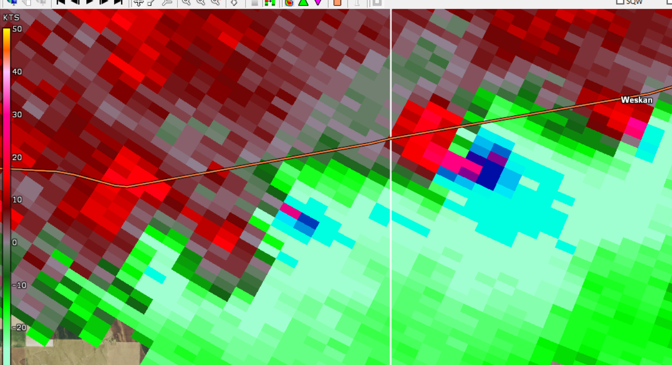
| Tornado striking a farmstead in northern Wallace County. Debris noted on radar imagery. Reflectivity, 5:16 pm MDT. | Tornado striking a farmstead in northern Wallace County. Debris noted on radar imagery. Correlation Coefficient, 5:16 pm MDT. | Tornado striking a farmstead in northern Wallace County. Debris noted on radar imagery. Storm Relative Velocity, 5:16 pm MDT. |
 |
 |
 |
 |
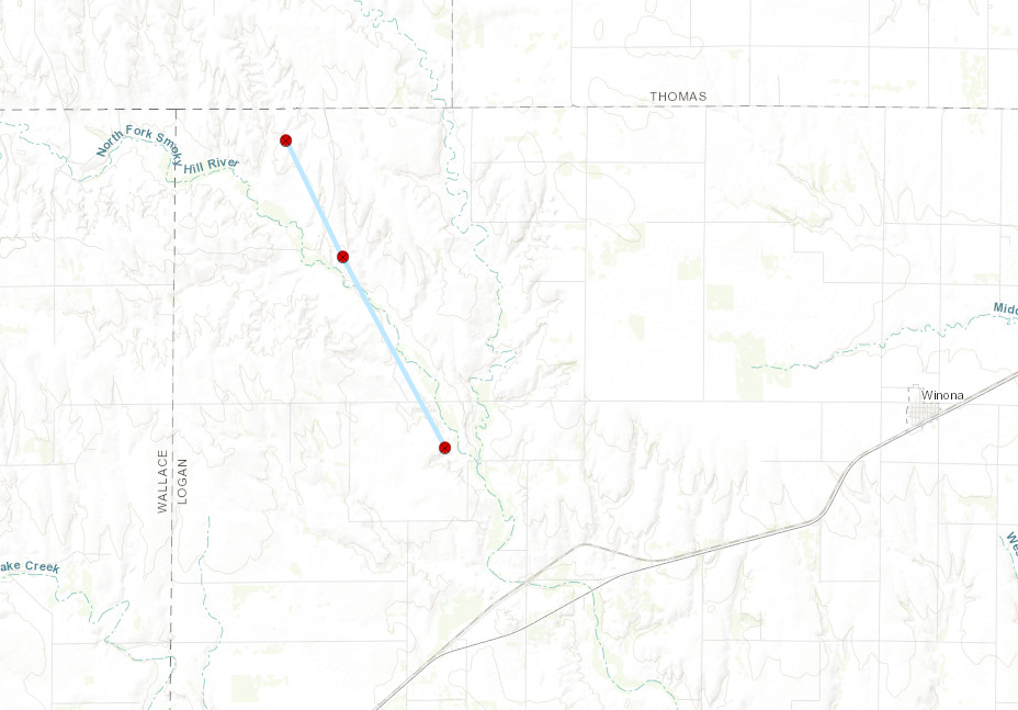
| Beginning of a tornado in NW Logan County, Kansas. Reflectivity, 6:25 pm CDT. | Beginning of a tornado in NW Logan County, Kansas. Storm Relative Velocity, 6:25 pm CDT. | Ending of a tornado in NW Logan County, Kansas. Reflectivity, 6:42 pm CDT. | Ending of a tornado in NW Logan County, Kansas. Storm Relative Velocity, 6:42 pm CDT. |
 |
 |
 |
| Tornado continues in NW Logan County, Kansas. Debris noted on radar imagery. Reflectivity, 6:35 pm CDT. | Tornado continues in NW Logan County, Kansas. Debris noted on radar imagery. Correlation Coefficient, 6:35 pm CDT. | Tornado continues in NW Logan County, Kansas. Debris noted on radar imagery. Storm Relative Velocity, 6:35 pm CDT. |
 |
 |
 |
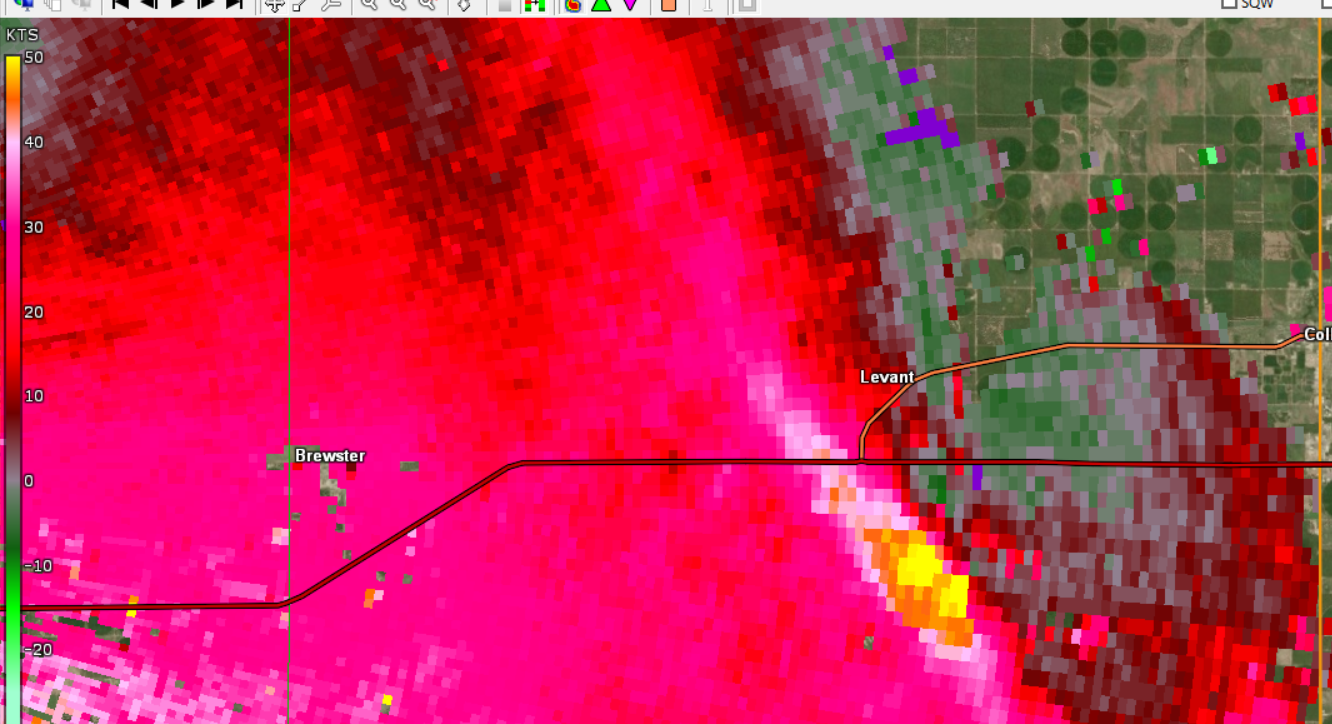 |
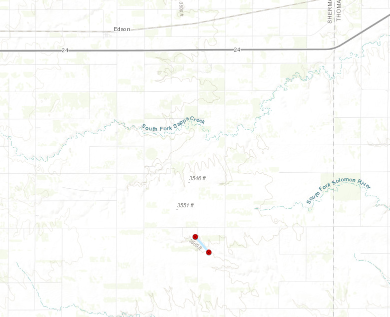
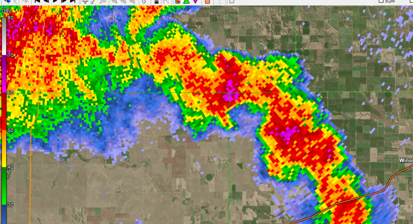
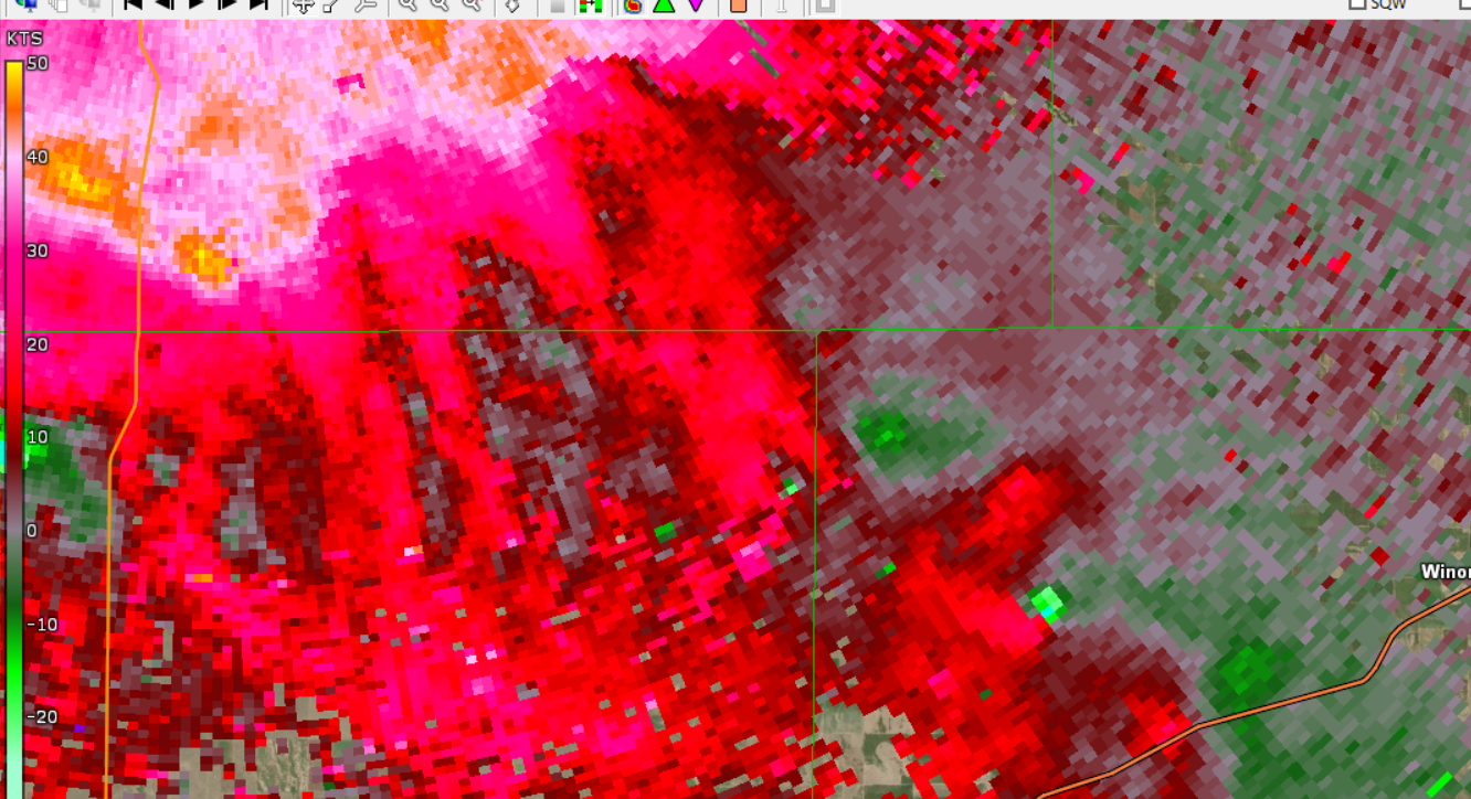
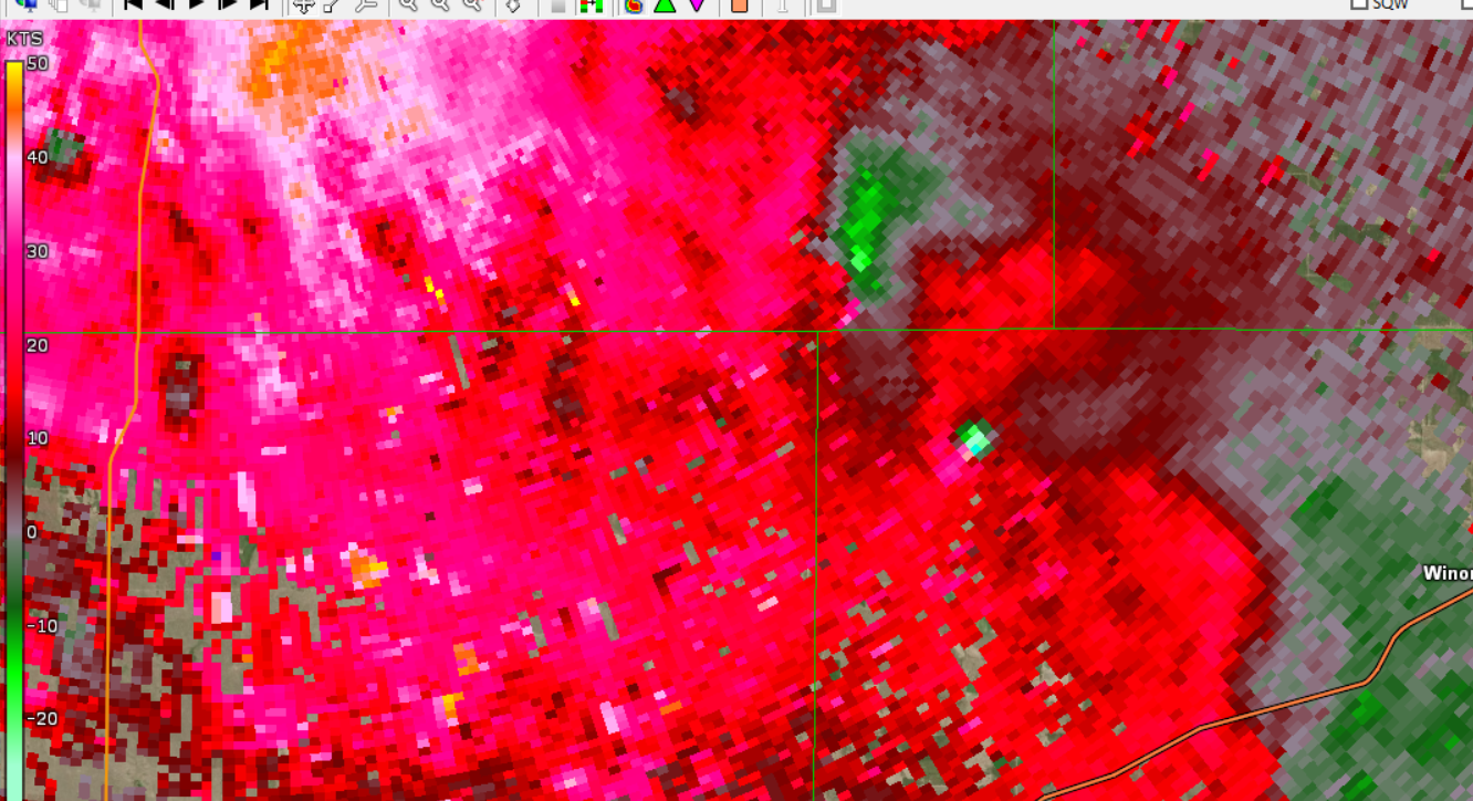
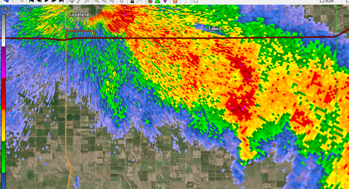
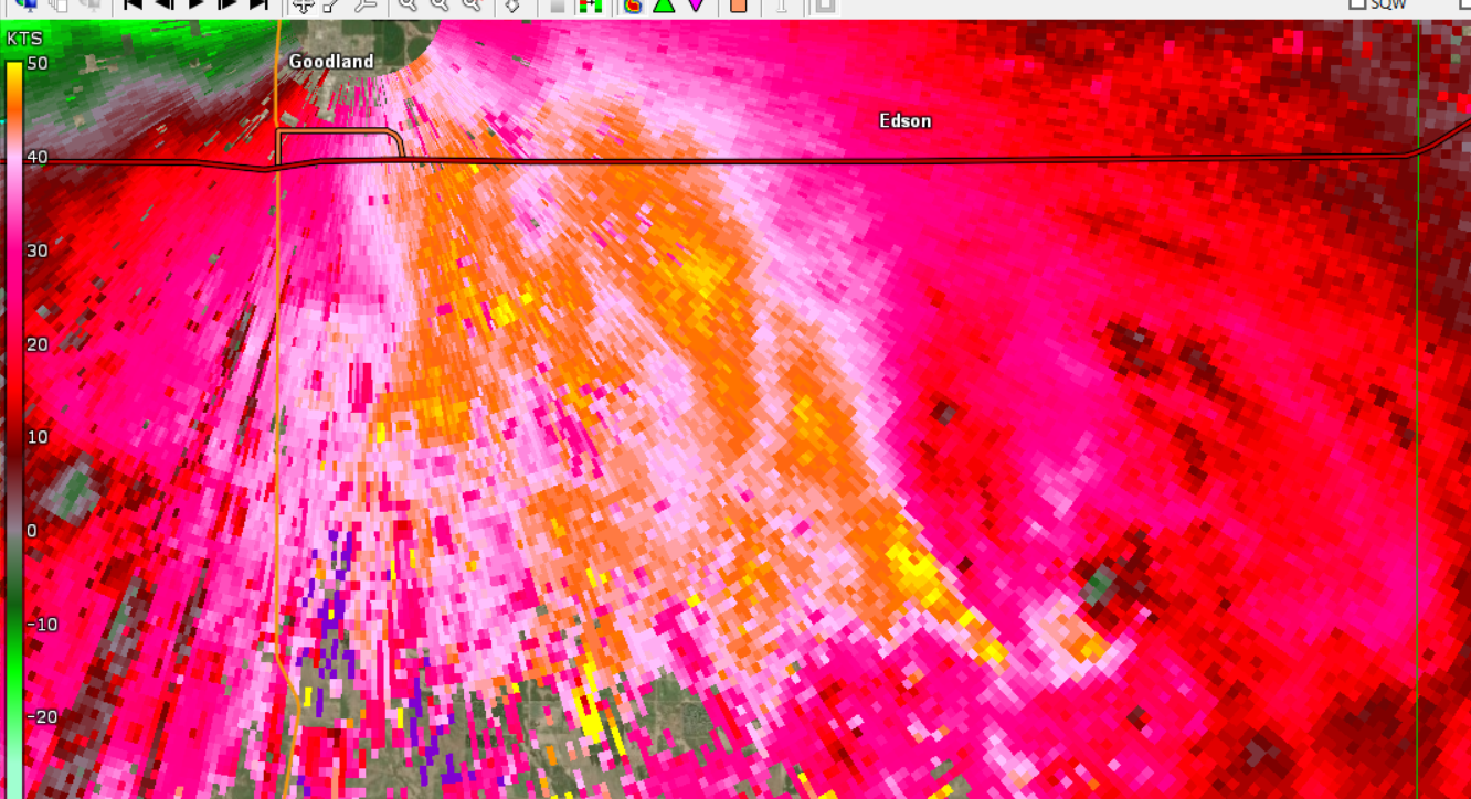
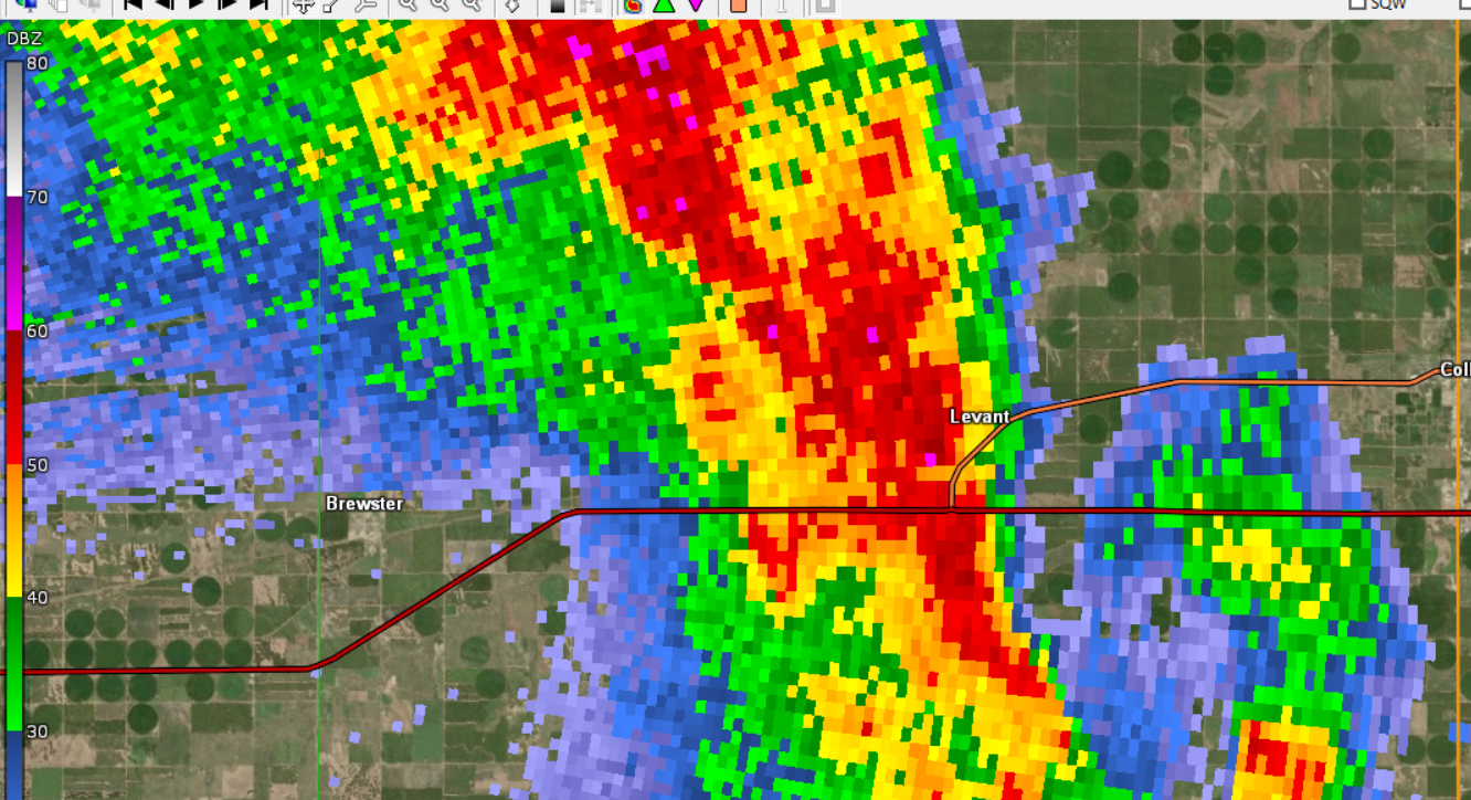
| Brief tornado south of Edson, Kansas in SE Sherman County. Reflectivity, 5:50 pm MDT. | Brief tornado south of Edson, Kansas in SE Sherman County. Storm Relative Velocity, 5:50 pm MDT. | Brief tornado south of Levant, Kansas in Thomas County. Reflectivity, 7:30 pm CDT. | Brief tornado south of Levant, Kansas in Thomas County. Storm Relative Velocity, 7:30 pm CDT. |
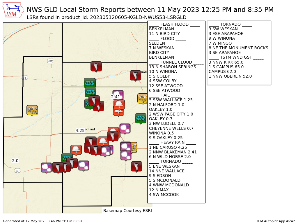
Storm Reports
..TIME... ...EVENT... ...CITY LOCATION... ...LAT.LON...
..DATE... ....MAG.... ..COUNTY LOCATION..ST.. ...SOURCE....
..REMARKS..
0448 PM HAIL 3 E WRAY 40.09N 102.17W
05/10/2023 E0.88 INCH YUMA CO STORM CHASER
REPORT VIA TWITTER WITH PHOTO OF HAIL UP TO
2 INCH IN DIAMETER EAST OF WRAY, CO.
0538 PM HAIL 3 NE KANONA 39.83N 100.34W
05/10/2023 M0.75 INCH DECATUR KS PUBLIC
REPORT FROM MPING: DIME (0.75 IN.).
0538 PM HAIL 3 NE KANONA 39.83N 100.34W
05/10/2023 M0.75 INCH DECATUR KS PUBLIC
REPORT FROM MPING: DIME (0.75 IN.).
0550 PM HAIL 2 NE KANONA 39.83N 100.37W
05/10/2023 M0.75 INCH DECATUR KS PUBLIC
REPORT FROM MPING: DIME (0.75 IN.).
0550 PM HAIL 2 NE KANONA 39.83N 100.37W
05/10/2023 M0.75 INCH DECATUR KS PUBLIC
REPORT FROM MPING: DIME (0.75 IN.).
0559 PM FLASH FLOOD 6 NW LEOVILLE 39.64N 100.54W
05/10/2023 DECATUR KS PUBLIC
REPORT FROM MPING: STREET/ROAD FLOODING;
STREET/ROAD CLOSED; VEHICLES STRANDED.
0559 PM FLASH FLOOD 6 NW LEOVILLE 39.64N 100.54W
05/10/2023 DECATUR KS PUBLIC
REPORT FROM MPING: STREET/ROAD FLOODING;
STREET/ROAD CLOSED; VEHICLES STRANDED.
0724 PM HAIL 6 S LEOVILLE 39.49N 100.44W
05/10/2023 M1.00 INCH SHERIDAN KS PUBLIC
REPORT FROM MPING: QUARTER (1.00 IN.).
0724 PM HAIL 6 S LEOVILLE 39.49N 100.44W
05/10/2023 M1.00 INCH SHERIDAN KS PUBLIC
REPORT FROM MPING: QUARTER (1.00 IN.).
1003 PM HAIL 1 NNE GOODLAND 39.37N 101.70W
05/10/2023 E0.25 INCH SHERMAN KS NWS EMPLOYEE
PEA SIZE HAIL IN GOODLAND, KS AT 10:03 PM
MDT.
0624 PM HAIL GRINNELL 39.12N 100.63W
05/10/2023 U0.50 INCH GOVE KS PUBLIC
REPORT FROM MPING: HALF-INCH (0.50 IN.).
0722 PM HAIL 5 S LEOVILLE 39.51N 100.44W
05/10/2023 U0.75 INCH SHERIDAN KS PUBLIC
REPORT FROM MPING: DIME (0.75 IN.).
0208 PM HAIL 6 N WINONA 39.14N 101.24W
05/10/2023 E1.00 INCH THOMAS KS TRAINED SPOTTER
HAIL WAS MOSTLY DIME SIZE BUT HAD A FEW
LARGER QUARTER SIZE HAIL REPORTS.
0230 PM TSTM WND GST 2 NW TASCO 39.37N 100.31W
05/10/2023 E50 MPH SHERIDAN KS PUBLIC
PUBLIC REPORT OF ESTIMATED 40-50 MPH WIND
GUSTS, SMALL HAIL (POPCORN SIZE). TIME
ESTIMATED.
0242 PM HAIL 2 WSW GRINNELL 39.11N 100.67W
05/10/2023 E0.50 INCH GOVE KS EMERGENCY MNGR
EMERGENCY MANAGER RELAYED REPORT OF PEA TO
HALF INCH HAIL. TIME AND LOCATION ESTIMATED.
0243 PM HAIL 11 SSE BREWSTER 39.22N 101.28W
05/10/2023 U0.75 INCH THOMAS KS PUBLIC
REPORT FROM MPING: DIME (0.75 IN.).
0245 PM HAIL 1 ESE CAMPUS 39.12N 100.71W
05/10/2023 U0.50 INCH GOVE KS PUBLIC
REPORT FROM MPING: HALF-INCH (0.50 IN.).
0257 PM TSTM WND GST 9 WSW WINONA 39.01N 101.40W
05/10/2023 M53 MPH LOGAN KS MESONET
0259 PM TSTM WND GST 5 S SELDEN 39.47N 100.57W
05/10/2023 M54 MPH SHERIDAN KS MESONET
0314 PM HAIL 10 N EDSON 39.47N 101.55W
05/10/2023 M1.75 INCH SHERMAN KS PUBLIC
LOCATION WAS ROAD 25 AND 72.
0314 PM TSTM WND GST 1 S TRIBUNE 38.45N 101.75W
05/10/2023 M52 MPH GREELEY KS AWOS
TRIBUNE AWOS.
0315 PM TSTM WND GST 3 N COLBY 39.43N 101.05W
05/10/2023 M50 MPH THOMAS KS AWOS
AWOS STATION KCBK 2 N COLBY.
0315 PM TSTM WND GST 2 ENE COLBY 39.40N 101.01W
05/10/2023 M62 MPH THOMAS KS MESONET
0321 PM TSTM WND GST 7 NNE TRIBUNE 38.57N 101.70W
05/10/2023 M50 MPH GREELEY KS MESONET
0325 PM HAIL 4 SE LEVANT 39.34N 101.13W
05/10/2023 E1.75 INCH THOMAS KS TRAINED SPOTTER
TRAINED SPOTTER REPORTS MOSTLY QUARTER SIZE
HAIL, SOME GOLF BALL SIZE HAIL AND 30 MPH
WINDS.
0342 PM FLASH FLOOD COLBY 39.39N 101.04W
05/10/2023 THOMAS KS TRAINED SPOTTER
WATER IS 6-7 INCHES DEEP ALONG THE CURB OF
COUNTRY CLUB DRIVE NEAR THE CEMETERY. THE
WATER IS NOT QUITE TO THE CENTER OF THE
STREET YET.
0350 PM TSTM WND GST 3 SE BEARDSLEY 39.79N 101.19W
05/10/2023 M50 MPH RAWLINS KS MESONET
0402 PM HAIL 11 N BIRD CITY 39.92N 101.54W
05/10/2023 U0.75 INCH CHEYENNE KS PUBLIC
REPORT FROM MPING: DIME (0.75 IN.).
0410 PM HAIL 1 ENE REXFORD 39.48N 100.72W
05/10/2023 E0.88 INCH THOMAS KS FIRE DEPT/RESCUE
REPORT OF NICKEL SIZE HAIL. TIME ESTIMATED.
0413 PM HEAVY RAIN 1 NE GEM 39.44N 100.88W
05/10/2023 M3.00 INCH THOMAS KS TRAINED SPOTTER
TRAINED SPOTTER REPORTS GAUGE SHOWING 3
INCHES OF RAIN, SMALL DRIFTS OF PEA SIZE
HAIL.
0414 PM HAIL 19 NW SAINT FRANCIS 39.98N 102.02W
05/10/2023 E1.00 INCH CHEYENNE KS PUBLIC
NICKEL TO QUARTER SIZE HAIL.
0415 PM HAIL 14 NW SAINT FRANCIS 39.93N 101.97W
05/10/2023 E1.00 INCH CHEYENNE KS TRAINED SPOTTER
TRAINED SPOTTER REPORTS 1 INCH HAIL AT RD 5
& RD Z IN CHEYENNE COUNTY, KS.
0418 PM FLASH FLOOD 1 NNW COLBY 39.40N 101.05W
05/10/2023 THOMAS KS TRAINED SPOTTER
FLOODING REPORTED IN COLBY WITH WATER GOING
OVER CAR HOODS, OVER STREET GUTTERS, AND
VILLA HIGH POND OVER BANKS.
0423 PM TSTM WND GST 5 S SELDEN 39.47N 100.57W
05/10/2023 M54 MPH SHERIDAN KS MESONET
0429 PM TORNADO 2 NW SELDEN 39.55N 100.59W
05/10/2023 SHERIDAN KS PUBLIC
TORNADO REPORTED 2W AND JUST NORTH OF
SELDEN.
0430 PM TORNADO 1 N DRESDEN 39.63N 100.42W
05/10/2023 DECATUR KS PUBLIC
TORNADO REPORTED TO BE JUST NORTH OF TOWN AT
THIS TIME.
0430 PM TSTM WND DMG 2 E SELDEN 39.55N 100.53W
05/10/2023 SHERIDAN KS LAW ENFORCEMENT
POSSIBLE TORNADO DAMAGE REPORTED.
OUTBUILDING LOST ROOF, CENTER PIVOTS
OVERTURNED AND NEARBY ROAD SIGNS BLOWN DOWN.
TIME ESTIMATED.
0431 PM TSTM WND GST 5 S SELDEN 39.47N 100.57W
05/10/2023 M66 MPH SHERIDAN KS MESONET
0434 PM HAIL 5 SSW LAIRD 40.02N 102.15W
05/10/2023 E1.00 INCH YUMA CO TRAINED SPOTTER
PEA TO QUARTER SIZE HAIL AND ESTIMATED 40-50
MPH WINDS REPORTED BY A TRAINED SPOTTER.
0434 PM TSTM WND GST SELDEN 39.54N 100.57W
05/10/2023 M66 MPH SHERIDAN KS MESONET
0434 PM TSTM WND GST 5 S SELDEN 39.47N 100.57W
05/10/2023 M67 MPH SHERIDAN KS MESONET
0437 PM TSTM WND GST 5 S SELDEN 39.47N 100.57W
05/10/2023 M81 MPH SHERIDAN KS MESONET
0445 PM HAIL WRAY 40.08N 102.22W
05/10/2023 E2.75 INCH YUMA CO LAW ENFORCEMENT
BASEBALL SIZE HAIL REPORTED BY LAW
ENFORCEMENT.
0445 PM TSTM WND GST 1 WNW LEOVILLE 39.58N 100.47W
05/10/2023 M50 MPH DECATUR KS MESONET
0448 PM HAIL 3 E WRAY 40.09N 102.17W
05/10/2023 E2.00 INCH YUMA CO STORM CHASER
CORRECTS PREVIOUS HAIL REPORT FROM 3 E WRAY.
REPORT VIA TWITTER WITH PHOTO OF HAIL UP TO
2 INCH IN DIAMETER EAST OF WRAY, CO.
0452 PM HAIL 4 S OBERLIN 39.76N 100.53W
05/10/2023 U0.75 INCH DECATUR KS PUBLIC
REPORT FROM MPING: DIME (0.75 IN.).
0455 PM FLASH FLOOD 1 NE GEM 39.44N 100.88W
05/10/2023 THOMAS KS TRAINED SPOTTER
TRAINED SPOTTER SENT PHOTO/VIDEO OF
FLOODING.
0507 PM HEAVY RAIN 1 NW COLBY 39.40N 101.06W
05/10/2023 M2.45 INCH THOMAS KS MESONET
2.45 INCHES OF STORM TOTAL RAINFALL SO FAR.
0509 PM HEAVY RAIN 1 SE COLBY 39.38N 101.04W
05/10/2023 M1.94 INCH THOMAS KS MESONET
1.94 INCHES OF STORM TOTAL RAINFALL SO FAR.
0510 PM HEAVY RAIN COLBY 39.39N 101.04W
05/10/2023 M2.83 INCH THOMAS KS MESONET
2.83 INCHES OF STORM TOTAL RAINFALL SO FAR.
0511 PM HEAVY RAIN 2 NE COLBY 39.41N 101.02W
05/10/2023 M2.15 INCH THOMAS KS MESONET
2.15 INCHES OF STORM TOTAL RAINFALL SO FAR.
0516 PM NON-TSTM WND GST 1 NNE GOODLAND 39.37N 101.70W
05/10/2023 M46 MPH SHERMAN KS ASOS
ASOS STATION KGLD GOODLAND. 1 MINUTE DATA
SHOWING VISIBILITY REDUCED TO 4SM DUE TO
BLOWING DUST FROM OUTFLOW TO THE SOUTHEAST
OF STATION.
0523 PM FLASH FLOOD 2 E SELDEN 39.55N 100.53W
05/10/2023 SHERIDAN KS LAW ENFORCEMENT
WATER RUNNING OVER ROADS AROUND THIS
LOCATION.
0524 PM TSTM WND GST 1 N ECKLEY 40.12N 102.49W
05/10/2023 M51 MPH YUMA CO MESONET
0525 PM HAIL MENLO 39.36N 100.72W
05/10/2023 E1.00 INCH THOMAS KS TRAINED SPOTTER
HAIL RANGED FROM PEA TO QUARTER IN SIZE.
0535 PM TSTM WND GST 11 NNE GOODLAND 39.49N 101.63W
05/10/2023 M53 MPH SHERMAN KS MESONET
0538 PM HAIL 3 NE KANONA 39.83N 100.34W
05/10/2023 U0.75 INCH DECATUR KS PUBLIC
REPORT FROM MPING: DIME (0.75 IN.).
0550 PM NON-TSTM WND GST 11 N BETHUNE 39.46N 102.41W
05/10/2023 M53 MPH KIT CARSON CO MESONET
0550 PM HAIL 2 NE KANONA 39.83N 100.37W
05/10/2023 U0.75 INCH DECATUR KS PUBLIC
REPORT FROM MPING: DIME (0.75 IN.).
0556 PM HAIL SELDEN 39.54N 100.57W
05/10/2023 E1.75 INCH SHERIDAN KS PUBLIC
REPORTED VIA LAW ENFORCEMENT.
0559 PM FLASH FLOOD 6 NW LEOVILLE 39.64N 100.54W
05/10/2023 DECATUR KS PUBLIC
REPORT FROM MPING: STREET/ROAD FLOODING;
STREET/ROAD CLOSED; VEHICLES STRANDED.
0603 PM TSTM WND GST 2 SW FIRSTVIEW 38.80N 102.55W
05/10/2023 M50 MPH CHEYENNE CO MESONET
0605 PM FLASH FLOOD 1 N GEM 39.44N 100.90W
05/10/2023 THOMAS KS PUBLIC
REPORT VIA SOCIAL MEDIA WITH PHOTO/VIDEO OF
FLOODING 1 MILE NORTH OF GEM.
0616 PM HAIL 1 ESE CHEYENNE WELLS 38.81N 102.33W
05/10/2023 E0.25 INCH CHEYENNE CO TRAINED SPOTTER
REPORT VIA SOCIAL MEDIA OF PEA SIZE HAIL IN
CHEYENNE WELLS.
0627 PM HAIL 7 S SEGUIN 39.25N 100.58W
05/10/2023 E1.00 INCH SHERIDAN KS TRAINED SPOTTER
0627 PM TSTM WND GST 7 S SEGUIN 39.25N 100.59W
05/10/2023 E60 MPH SHERIDAN KS TRAINED SPOTTER
TORRENTIAL RAIN ALSO OBSERVED.
0630 PM HAIL 5 S SEGUIN 39.27N 100.59W
05/10/2023 E1.00 INCH SHERIDAN KS PUBLIC
PEA TO QUARTER SIZED HAIL WAS ONGOING AT
TIME OF THE REPORT. HAIL WAS ACCUMULATING ON
THE GROUND.
0724 PM HAIL 6 S LEOVILLE 39.49N 100.44W
05/10/2023 U1.00 INCH SHERIDAN KS PUBLIC
REPORT FROM MPING: QUARTER (1.00 IN.).
0815 AM HEAVY RAIN 3 N KANORADO 39.38N 102.04W
05/11/2023 M2.28 INCH SHERMAN KS PUBLIC
CORRECTS PREVIOUS HEAVY RAIN REPORT FROM 3 N
KANORADO. 24 HOUR TOTAL.
0841 AM HEAVY RAIN 5 N BLAKEMAN 39.89N 101.13W
05/11/2023 E1.22 INCH RAWLINS KS TRAINED SPOTTER
0235 PM HAIL WINONA 39.06N 101.24W
05/10/2023 E1.25 INCH LOGAN KS PUBLIC
DELAYED REPORT. QUARTER TO HALF DOLLAR SIZED
HAIL OBSERVED. TIME ESTIMATED.
0500 AM HEAVY RAIN OAKLEY 39.13N 100.86W
05/11/2023 M1.02 INCH LOGAN KS EMERGENCY MNGR
STORM TOTAL PRECIPITATION OVER THE LAST 24
HOURS.
0500 AM HEAVY RAIN 2 E CAMPUS 39.13N 100.70W
05/11/2023 M1.00 INCH GOVE KS PUBLIC
STORM TOTAL PRECIPITATION OVER THE LAST 24
HOURS.
0902 AM HEAVY RAIN COLBY 39.39N 101.05W
05/11/2023 M3.00 INCH THOMAS KS PUBLIC
STORM TOTAL PRECIPITATION OVER THE LAST 24
HOURS.
0500 AM HEAVY RAIN 3 E ANGELUS 39.18N 100.63W
05/11/2023 M2.10 INCH SHERIDAN KS PUBLIC
STORM TOTAL PRECIPITATION OVER THE LAST 24
HOURS.
0630 AM HEAVY RAIN 1 WNW COLBY 39.39N 101.06W
05/11/2023 M3.50 INCH THOMAS KS PUBLIC
STORM TOTAL PRECIPITATION OVER THE LAST 24
HOURS.
0700 AM HEAVY RAIN 5 S SEGUIN 39.26N 100.61W
05/11/2023 M4.00 INCH SHERIDAN KS PUBLIC
STORM TOTAL PRECIPITATION OVER THE LAST 24
HOURS.
0630 AM HEAVY RAIN 3 E ANGELUS 39.18N 100.63W
05/11/2023 M2.10 INCH SHERIDAN KS PUBLIC
STORM TOTAL PRECIPITATION OVER THE LAST 24
HOURS.
0900 AM HEAVY RAIN 5 E MAX 40.10N 101.31W
05/11/2023 M2.90 INCH HITCHCOCK NE PUBLIC
STORM TOTAL PRECIPITATION OVER THE LAST 24
HOURS.
0902 AM HEAVY RAIN 5 ESE MAX 40.08N 101.31W
05/11/2023 M3.00 INCH HITCHCOCK NE PUBLIC
STORM TOTAL PRECIPITATION OVER THE LAST 24
HOURS.
0903 AM HEAVY RAIN 4 ESE MAX 40.09N 101.32W
05/11/2023 M2.60 INCH HITCHCOCK NE PUBLIC
STORM TOTAL PRECIPITATION OVER THE LAST 24
HOURS.
0906 AM HEAVY RAIN 7 SSW CARUSO 39.25N 101.84W
05/11/2023 E2.10 INCH SHERMAN KS PUBLIC
STORM TOTAL PRECIPITATION OVER THE LAST 24
HOURS.
1008 AM HEAVY RAIN 7 NNW PECONIC 39.41N 102.21W
05/11/2023 M1.31 INCH KIT CARSON CO PUBLIC
STORM TOTAL PRECIPITATION OVER THE LAST 24
HOURS.
0940 AM HEAVY RAIN 5 S GOODLAND 39.28N 101.71W
05/11/2023 M3.30 INCH SHERMAN KS PUBLIC
SOCIAL MEDIA REPORT WITH PICTURE. TOTAL FROM
STORMS YESTERDAY AND LAST NIGHT.
1000 AM HEAVY RAIN 1 NW COLBY 39.40N 101.06W
05/11/2023 M2.88 INCH THOMAS KS PUBLIC
SOCIAL MEDIA REPORT WITH PICTURE OF STORM
TOTAL RAINFALL YESTERDAY AND LAST NIGHT.
0342 AM HEAVY RAIN 1 E SAINT FRANCIS 39.77N 101.79W
05/11/2023 M2.02 INCH CHEYENNE KS TRAINED SPOTTER
STORM TOTAL RAINFALL UP TO THE TIME OF
REPORT.
0612 AM HEAVY RAIN 8 S CARUSO 39.22N 101.80W
05/11/2023 E2.00 INCH SHERMAN KS PUBLIC
SOCIAL MEDIA REPORT OF EXACTLY TWO INCHES OF
RAIN FOR STORMS UP UNTIL TIME OF REPORT.
1045 AM HEAVY RAIN 4 SW GOODLAND 39.31N 101.75W
05/11/2023 M2.60 INCH SHERMAN KS PUBLIC
TOTAL RAINFALL UP UNTIL TIME OF REPORT.
1105 AM HEAVY RAIN 1 W KANONA 39.80N 100.40W
05/11/2023 M3.60 INCH DECATUR KS PUBLIC
RAINFALL TOTAL THROUGH TIME OF REPORT.
0440 PM HEAVY RAIN GEM 39.43N 100.90W
05/10/2023 M5.07 INCH THOMAS KS PUBLIC
SOCIAL MEDIA REPORT WITH PICTURE OF JUST
OVER 5 INCHES OF RAIN UP UNTIL THE TIME OF
THE REPORT.
1150 AM HEAVY RAIN 5 NW SELDEN 39.59N 100.63W
05/11/2023 M4.20 INCH DECATUR KS PUBLIC
SOCIAL MEDIA REPORT OF TOTAL RAINFALL
THROUGH TIME OF REPORT. ALSO REPORTED TOTAL
PEA SIZED HAIL ACCUMULATIONS OF 2 INCHES.
 |
PRELIMINARY LOCAL STORM REPORT...SUMMARY
NATIONAL WEATHER SERVICE GOODLAND KS
1205 AM MDT FRI MAY 12 2023

..TIME...   ...EVENT...      ...CITY LOCATION...     ...LAT.LON...
..DATE...   ....MAG....      ..COUNTY LOCATION..ST.. ...SOURCE....
            ..REMARKS..

1225 PM     TSTM WND GST     3 NNW KIRK              39.66N 102.62W
05/11/2023  M65 MPH          YUMA               CO   MESONET

            COAGMET SITE AT KIRK (KRK01).

0240 PM     TSTM WND GST     1 S CAMPUS              39.11N 100.74W
05/11/2023  M65 MPH          GOVE               KS   NWS EMPLOYEE

            OFF DUTY EMPLOYEE REPORTED 60 TO 65 MPH WIND
            GUSTS AND PEA TO HALF INCH HAIL.

0239 PM     TSTM WND GST     CAMPUS                  39.12N 100.74W
05/11/2023  M62 MPH          GOVE               KS   MESONET

            SITE WPE WEATHER.

0835 PM     TSTM WND GST     1 NNW OBERLIN           39.83N 100.53W
05/11/2023  M52 MPH          DECATUR            KS   AWOS

            AWOS STATION KOIN OBERLIN.

1240 PM     TORNADO          5 S MCDONALD            39.72N 101.37W
05/11/2023                   RAWLINS            KS   911 CALL CENTER

            ONGOING RAIN WRAPPED TORNADO REPORTED SOUTH
            OF MCDONALD.

1251 PM     TORNADO          4 WNW MCDONALD          39.80N 101.45W
05/11/2023                   CHEYENNE           KS   PUBLIC

            CALLER REPORTED A BRIEF TORNADO AT THE
            INTERSECTION OF ROAD 33 AND ROAD Q.

0204 PM     TORNADO          12 N MAX                40.29N 101.41W
05/11/2023                   DUNDY              NE   TRAINED SPOTTER

            SOCIAL MEDIA REPORT OF POSSIBLE TORNADO
            (RAIN WRAPPED) IN NORTHERN DUNDY COUNTY.
            SPOT ESTIMATED BY RADAR.

0210 PM     TORNADO          8 NE THE MONUMENT ROCKS 38.84N 100.65W
05/11/2023                   GOVE               KS   TRAINED SPOTTER

            SPOTTER REPORTED BRIEF SPIN UP TORNADO. NOT
            ONGOING AS OF CALL AT 2012Z.

0415 PM     TORNADO          4 SW MCCOOK             40.16N 100.67W
05/11/2023                   RED WILLOW         NE   PUBLIC

            RELAYED REPORT FROM DISPATCH OF A PUBLIC
            REPORT OF A TORNADO ON THE GROUND. COULD NOT
            CONFIRM IF IT WAS STILL ON THE GROUND.

0441 PM     TORNADO          3 SW WESKAN             38.83N 102.00W
05/11/2023                   WALLACE            KS   TRAINED SPOTTER

            SPOTTER REPORTED A MULTI-VORTEX TORNADO JUST
            SOUTHWEST OF WESKAN.

0445 PM     TORNADO          3 ESE ARAPAHOE          38.83N 102.13W
05/11/2023                   CHEYENNE           CO   TRAINED SPOTTER

            SPOTTER REPORTED TWO TORNADOES 2 EAST AND
            1.5 MILES SOUTH OF ARAPAHOE.

0445 PM     TORNADO          3 SE ARAPAHOE           38.82N 102.13W
05/11/2023                   CHEYENNE           CO   TRAINED SPOTTER

            TRAINED SPOTTER REPORTED ABOUT 3 MILES
            SOUTHEAST OF ARAPAHOE, CO. TORNADOES ARE
            SHORT LIVED ONLY LASTING A MINUTE OR SO,
            LIFTING, AND DROPPING AGAIN. MULTI-VORTEX
            TORNADO REPORTED.

0451 PM     TORNADO          5 ENE WESKAN            38.89N 101.87W
05/11/2023                   WALLACE            KS   TRAINED SPOTTER

            REPORT OF A RAIN-WRAPPED, WEAK TORNADO THAT
            CROSSED HIGHWAY 40.

0535 PM     TORNADO          14 NNE WALLACE          39.11N 101.54W
05/11/2023                   WALLACE            KS   TRAINED SPOTTER

            SPOTTER REPORTED TORNADO 15 MILES SOUTH OF
            EDSON.

0541 PM     TORNADO          9 W WINONA              39.08N 101.42W
05/11/2023                   LOGAN              KS   LAW ENFORCEMENT

            MULTIPLE REPORTS OF A TORNADO ONGOING AT 170
            AND APACHE ACRES.

0547 PM     TORNADO          9 S EDSON               39.20N 101.51W
05/11/2023                   SHERMAN            KS   TRAINED SPOTTER

            PHOTO OF TORNADO 15 MILES SOUTHEAST OF
            GOODLAND, KS.

0630 PM     TORNADO          7 W MINGO               39.28N 101.10W
05/11/2023                   THOMAS             KS   TRAINED SPOTTER

            MULTIPLE SPOTTERS REPORTED A BRIEF TORNADO.

0302 PM     HEAVY RAIN       1 NE CARUSO             39.35N 101.80W
05/11/2023  E4.25 INCH       SHERMAN            KS   PUBLIC

            SOCIAL MEDIA REPORT OF RAINFALL ACROSS FOR
            TODAY AND YESTERDAY (36HR TOTAL).

0437 PM     HEAVY RAIN       2 NNW BLAKEMAN          39.84N 101.13W
05/11/2023  M2.41 INCH       RAWLINS            KS   TRAINED SPOTTER

            SPOTTER REPORTED 2.41 INCHES OF RAIN TODAY.
            (12 HOUR TOTAL).

1240 PM     HEAVY RAIN       6 N WILD HORSE          38.91N 103.00W
05/11/2023  M2.00 INCH       CHEYENNE           CO   PUBLIC

            24 HOUR RAINFALL REPORT.

0507 PM     HAIL             5 SSW WALLACE           38.85N 101.65W
05/11/2023  E1.25 INCH       WALLACE            KS   PUBLIC

            SOCIAL MEDIA REPORT WITH VIDEO.

0604 PM     HAIL             2 WSW PAGE CITY         39.08N 101.19W
05/11/2023  E1.00 INCH       LOGAN              KS   TRAINED SPOTTER

            SPOTTER REPORTED ONE INCH HAIL.

0711 PM     HAIL             2 N HALFORD             39.39N 100.87W
05/11/2023  E1.00 INCH       THOMAS             KS   TRAINED SPOTTER

            TRAINED SPOTTER REPORTS NICKEL TO QUARTER
            SIZE HAIL AT HWY 83 AND HWY 24.

0719 PM     HAIL             OAKLEY                  39.13N 100.86W
05/11/2023  M1.00 INCH       LOGAN              KS   EMERGENCY MNGR

            REPORT OF MEASURED HAIL UP TO 1 INCH.

0114 PM     HAIL             3 NW LUDELL             39.88N 101.00W
05/11/2023  E0.70 INCH       RAWLINS            KS   TRAINED SPOTTER

            PEA TO DIME SIZED HAIL OBSERVED WITH HEAVY
            RAINFALL.

0340 PM     HAIL             CHEYENNE WELLS          38.82N 102.35W
05/11/2023  E0.70 INCH       CHEYENNE           CO   PUBLIC

            INTERMITTENT PEA TO DIME SIZED HAIL ONGOING.

0703 PM     HAIL             OAKLEY                  39.12N 100.85W
05/11/2023  E0.70 INCH       LOGAN              KS   EMERGENCY MNGR

            REPORT OF PEA TO DIME SIZE HAIL, HEAVY RAIN
            IN OAKLEY.

0605 PM     HAIL             WINONA                  39.06N 101.24W
05/11/2023  E0.50 INCH       LOGAN              KS   TRAINED SPOTTER

            SPOTTER REPORTS 0.25-0.5 INCH HAIL, NOT A
            LOT BUT SOME.

0643 PM     HAIL             9 S OAKLEY              39.00N 100.85W
05/11/2023  E0.25 INCH       LOGAN              KS   PUBLIC

            SOCIAL MEDIA REPORT OF PEA SIZED HAIL 9
            MILES SOUTH OF OAKLEY, KS.

0255 PM     FUNNEL CLOUD     12 SSE ATWOOD           39.65N 100.99W
05/11/2023                   RAWLINS            KS   911 CALL CENTER

            DISPATCH REPORTED FUNNEL CLOUD SOUTH OF
            ATWOOD. LOCATION IS APPROXIMATE AND TIME
            ESTIMATED.

0303 PM     FUNNEL CLOUD     6 SSE ATWOOD            39.74N 100.98W
05/11/2023                   RAWLINS            KS   PUBLIC

            SOCIAL MEDIA REPORT OF A BRIEF FUNNEL CLOUD.
            LOCATION IS ESTIMATED BASED OFF REPORT AND
            RADAR. REPORTEE WAS LOCATED 3 MILES WEST OF
            ATWOOD AND LOOKING SOUTHEAST.

0516 PM     FUNNEL CLOUD     13 N SHARON SPRINGS     39.08N 101.79W
05/11/2023                   WALLACE            KS   TRAINED SPOTTER

            SPOTTER REPORTED FUNNEL CLOUD.

0627 PM     FUNNEL CLOUD     10 N WINONA             39.20N 101.28W
05/11/2023                   THOMAS             KS   TRAINED SPOTTER

            SPOTTER LOCATED IN BREWSTER OBSERVED FUNNEL
            CLOUD.

0630 PM     FUNNEL CLOUD     5 S COLBY               39.32N 101.06W
05/11/2023                   THOMAS             KS   PUBLIC

            FUNNEL CLOUD 3/4 OF WAY TO THE GROUND
            LOOKING TOWARDS WINONA FROM THE REPORT
            LOCATION.

0631 PM     FUNNEL CLOUD     4 SSW COLBY             39.34N 101.09W
05/11/2023                   THOMAS             KS   STORM CHASER

            CHASER LOCATED 3 ESE OF LEVANT SAW FUNNEL
            CLOUD ALMOST TO THE GROUND 5 MILES TO THE
            SOUTH OF HIS LOCATION.

0135 PM     FLOOD            7 N WESKAN              38.96N 101.96W
05/11/2023                   WALLACE            KS   911 CALL CENTER

            REPORT OF A SMALL BARN DAMAGED DUE TO
            FLOODING. RAINFALL AMOUNT UNKNOWN AT THIS
            TIME.

0240 PM     FLOOD            BIRD CITY               39.75N 101.53W
05/11/2023                   CHEYENNE           KS   EMERGENCY MNGR

            SEVERAL STREETS IN BIRD CITY ARE BECOMING
            COVERED WITH WATER. WATER DEPTH IS UNKNOWN
            AT THIS TIME.

0245 PM     FLOOD            BENKELMAN               40.05N 101.53W
05/11/2023                   DUNDY              NE   EMERGENCY MNGR

            STREET FLOODING IS OCCURRING IN BENKELMAN.
            THERE IS AN UNKNOWN AMOUNT OF WATER ON
            ROADS.

0405 PM     FLOOD            SELDEN                  39.54N 100.57W
05/11/2023                   SHERIDAN           KS   TRAINED SPOTTER

            SPOTTER VIDEO SHOWED AT LEAST 6 INCHES OF
            WATER COVERING HIGHWAY 83.

0250 PM     FLASH FLOOD      BENKELMAN               40.05N 101.54W
05/11/2023                   DUNDY              NE   EMERGENCY MNGR

            VIDEO OF WATER RUNNING DOWN THE ROAD ABOUT 6
            TO 12 INCHES DEEP.

0305 PM     FLASH FLOOD      11 N BIRD CITY          39.92N 101.52W
05/11/2023                   CHEYENNE           KS   PUBLIC

            SOCIAL MEDIA REPORT WITH PICTURES OF A
            COUNTY ROAD WASHED AWAY AT POINTS AND WITH
            AROUND 6 TO 12 INCHES OF WATER ON ROAD IN A
            LOW SPOT.
 |
Media use of NWS Web News Stories is encouraged! Please acknowledge the NWS as the source of any news information accessed from this site. |
|