Overview
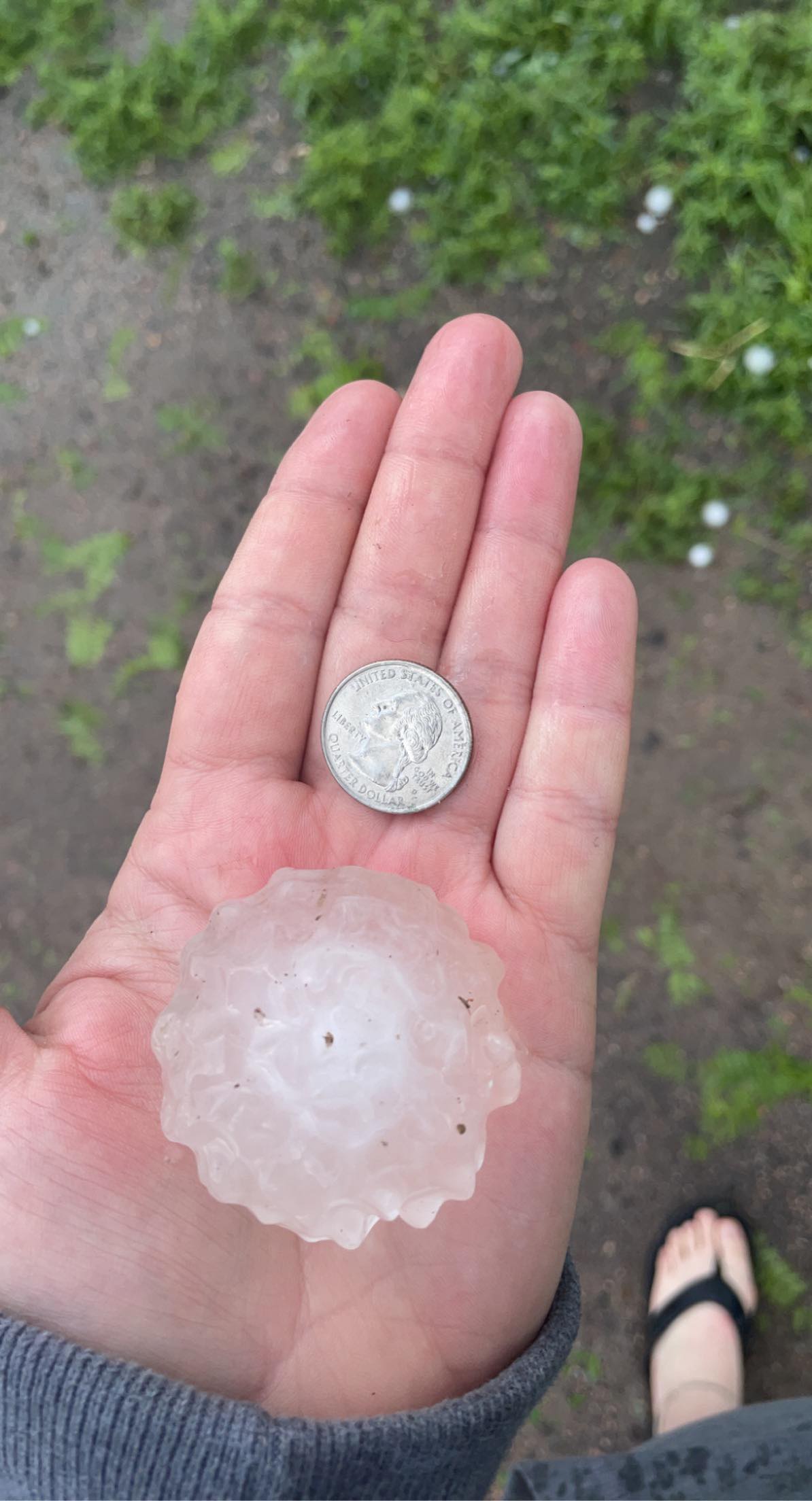
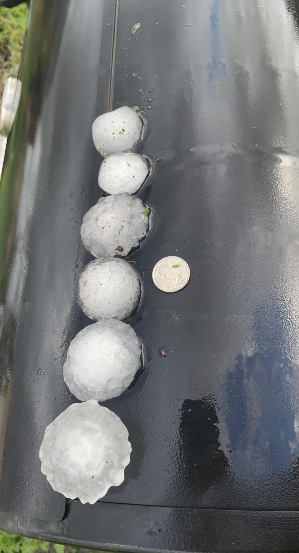
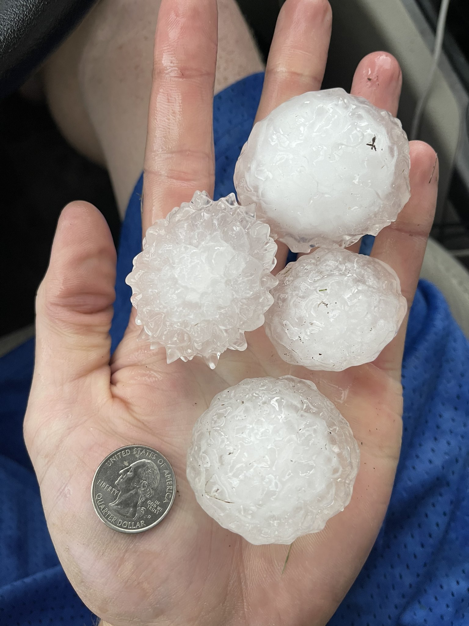
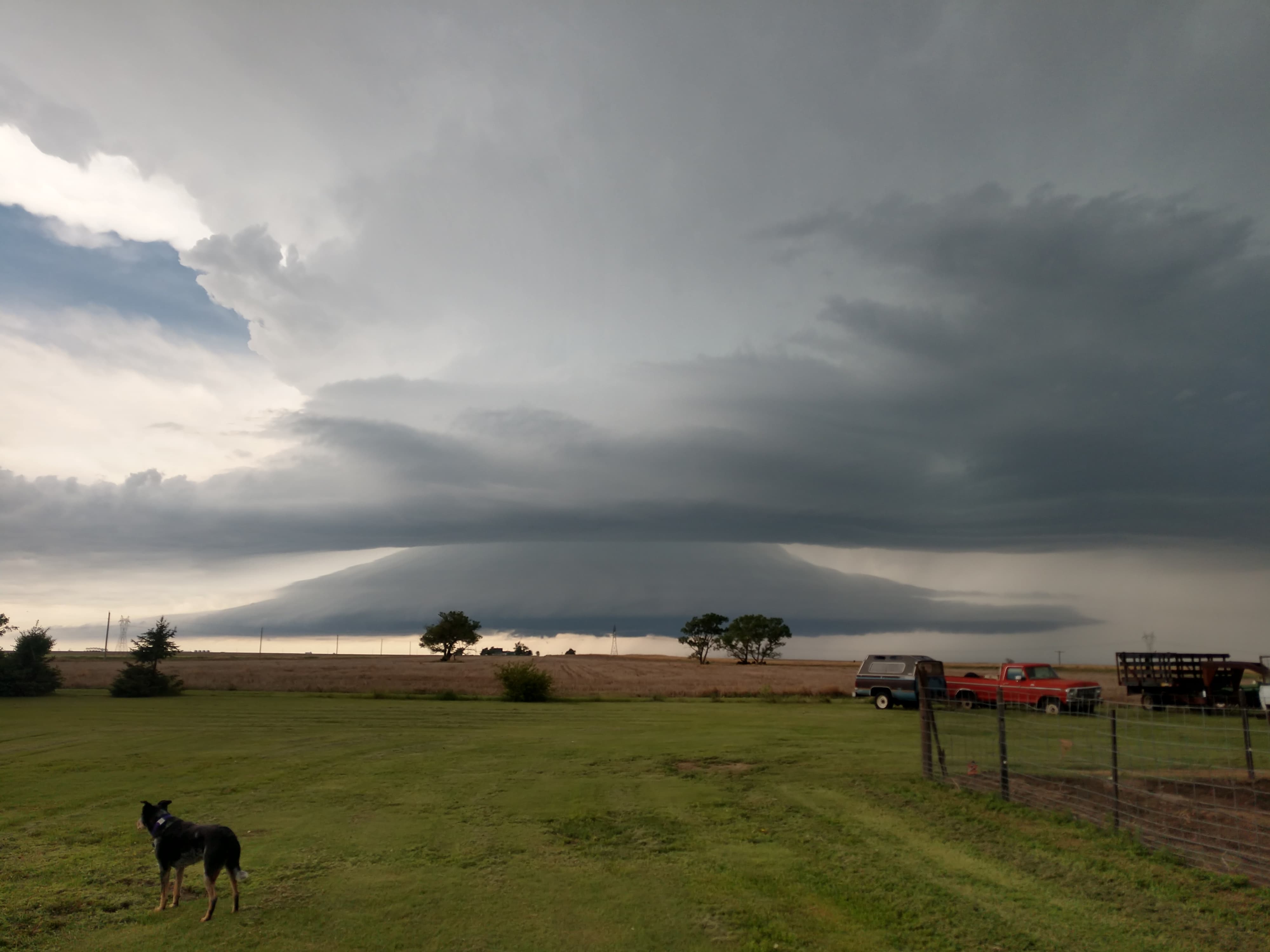
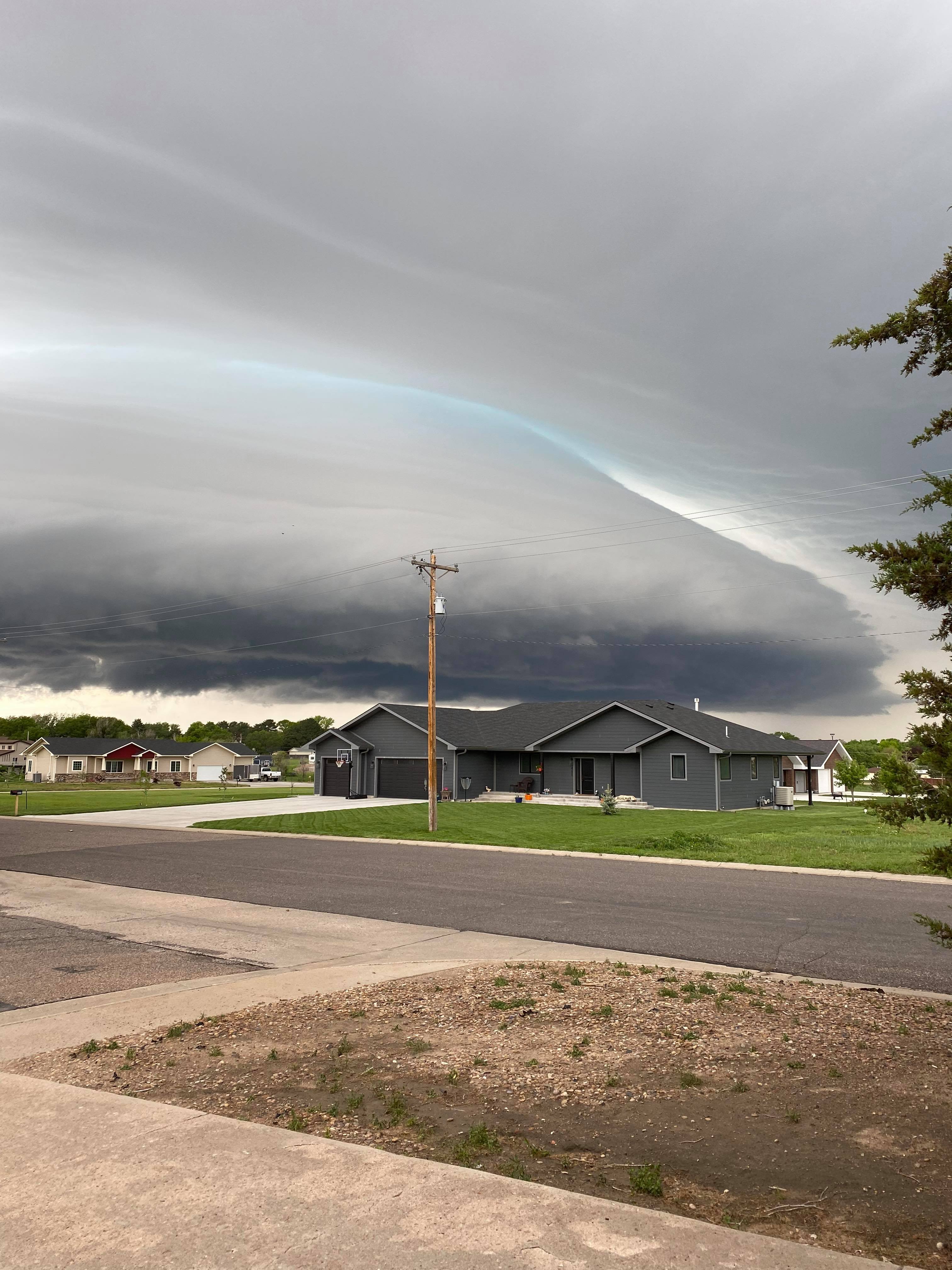
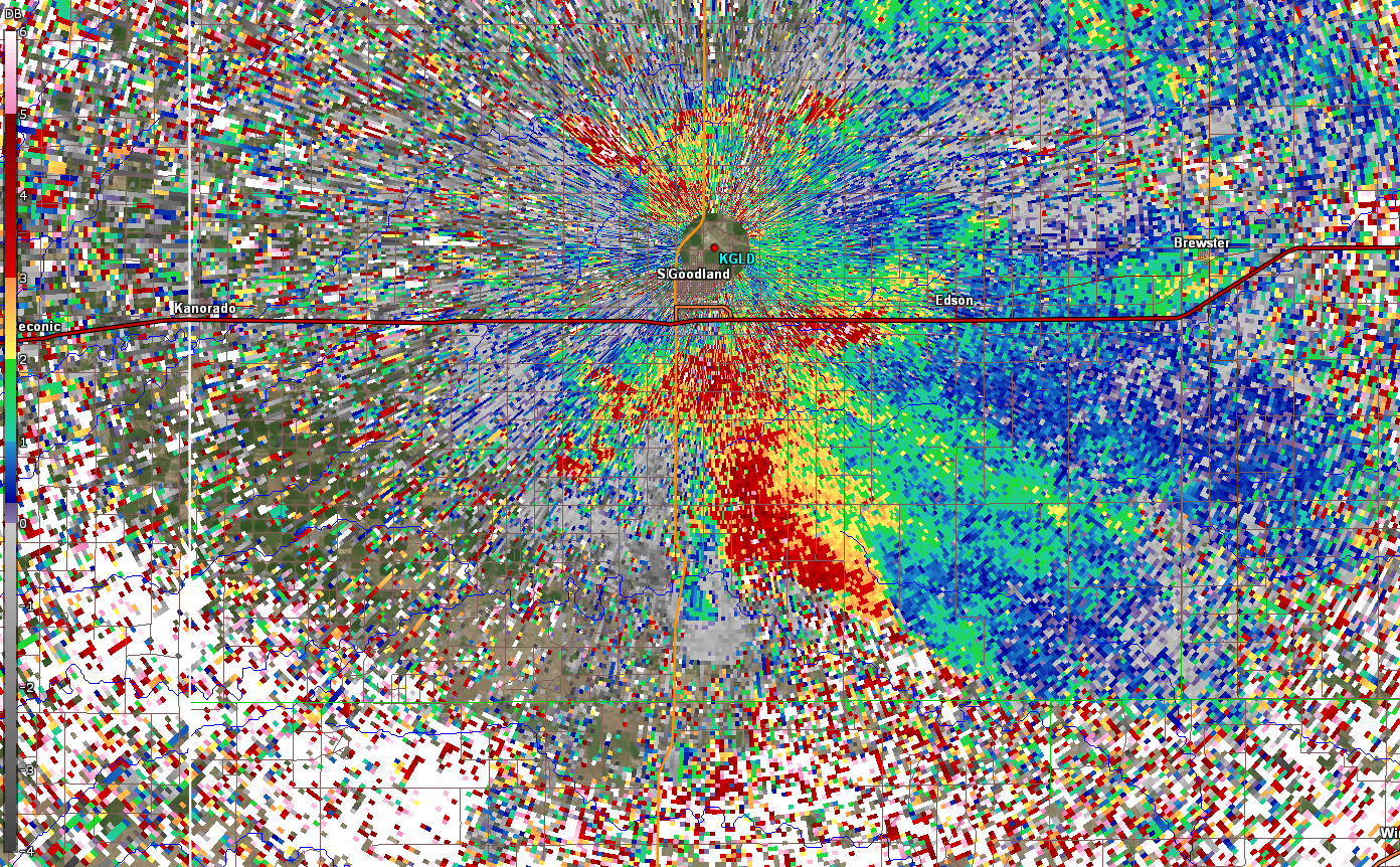
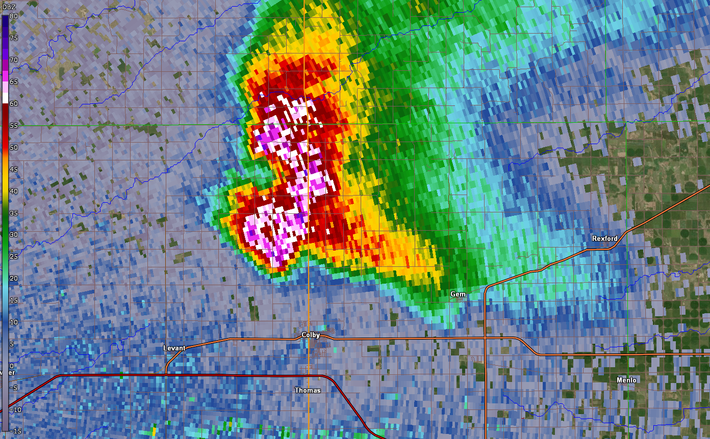
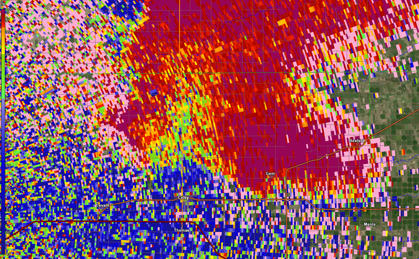
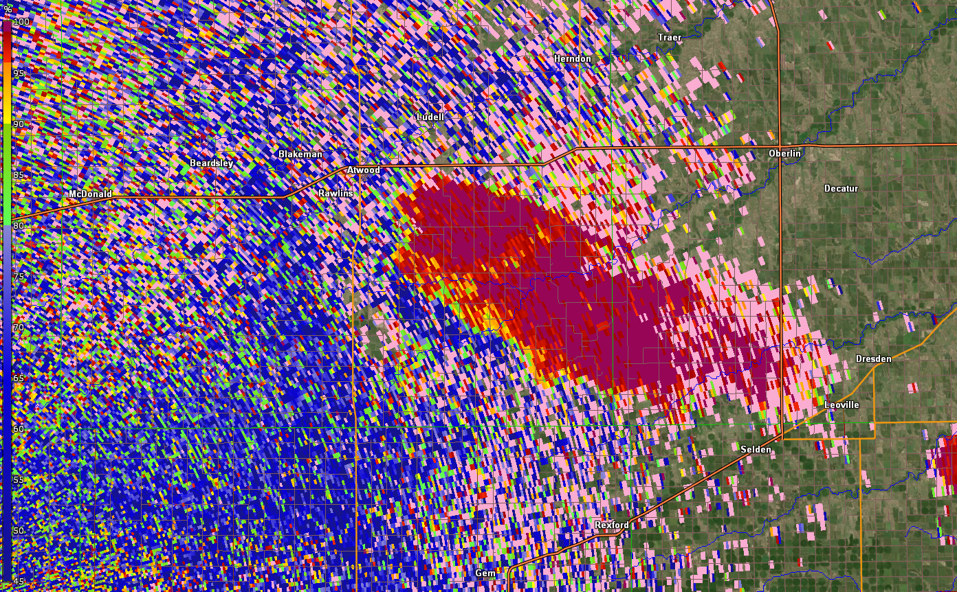
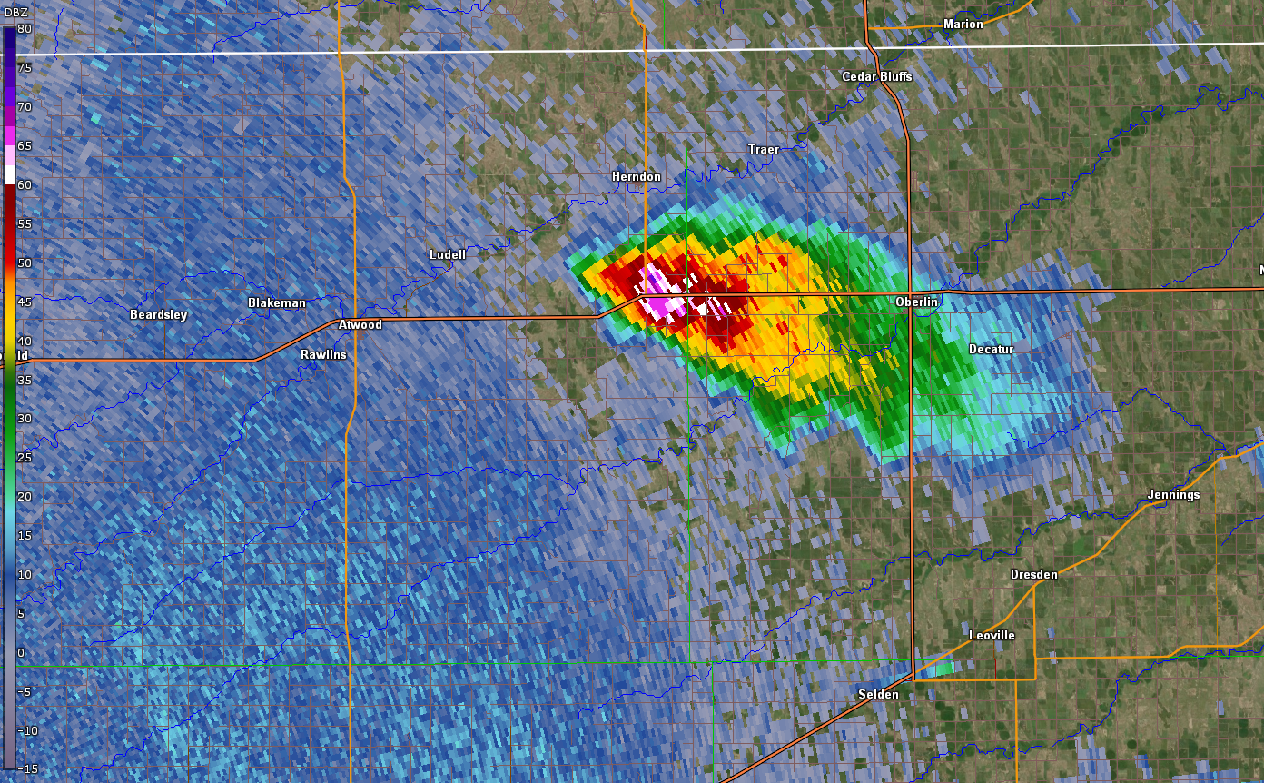
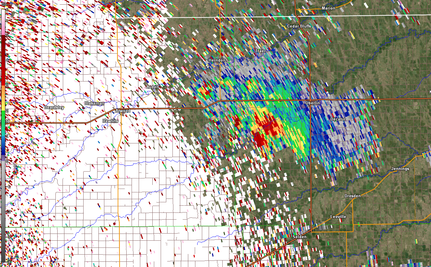
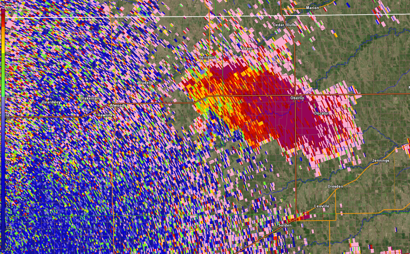
More than one round of thunderstorms impacted the region on May 26th, 2021. Early in the day, thunderstorms developed in northwest Kansas. A supercell thunderstorm traveled from Sherman county northeastward to Thomas county through the morning hours. This storm began to weaken as it reached central Decatur county, eventually dissipating near the Nebraska border in the early afternoon. On its way across northwest Kansas, this severe thunderstorm produced up to tennis ball size hail which damaged vehicles and property.
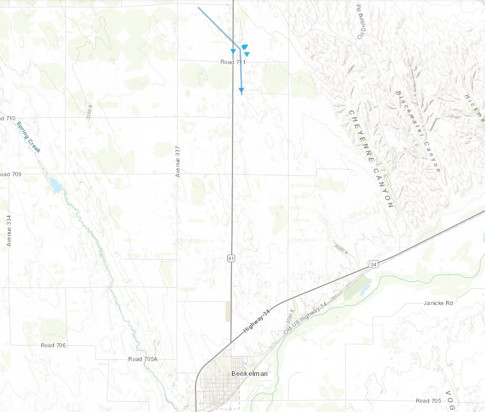
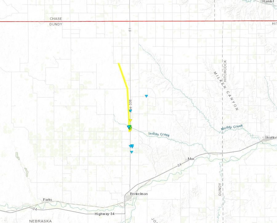
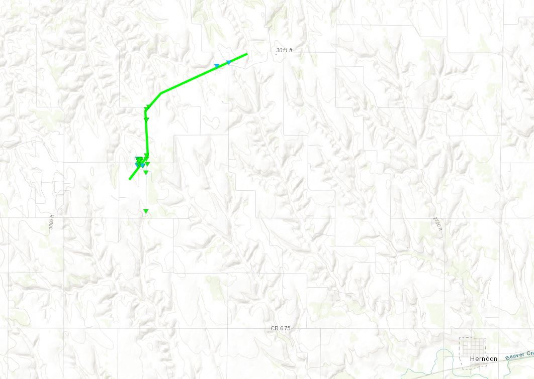
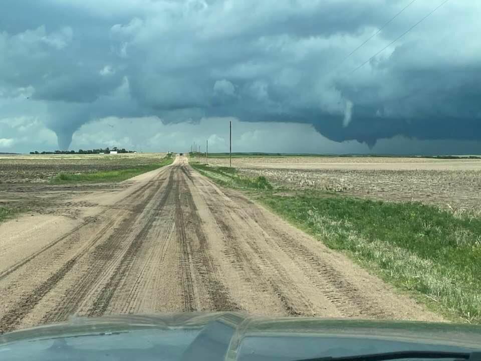
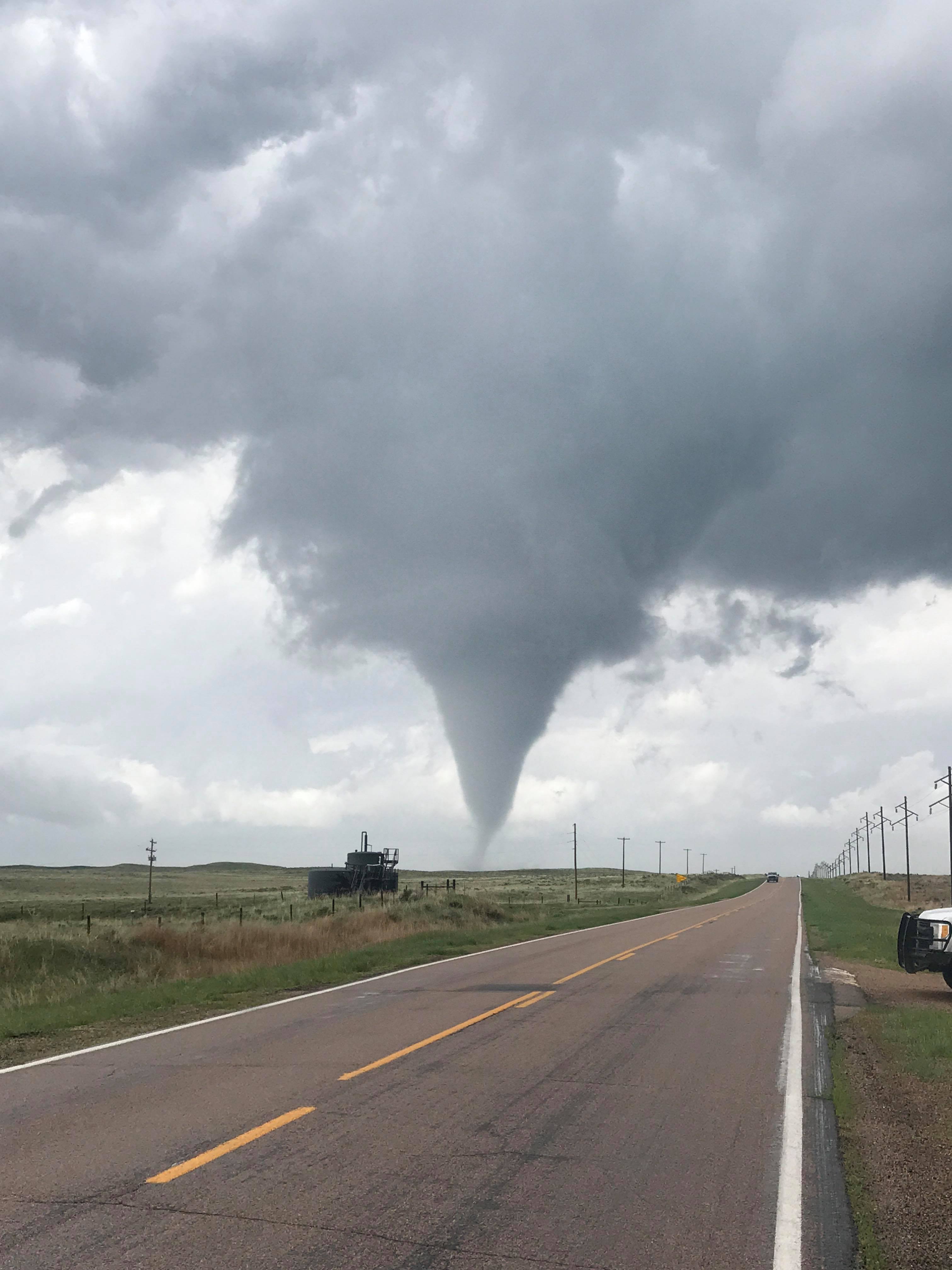
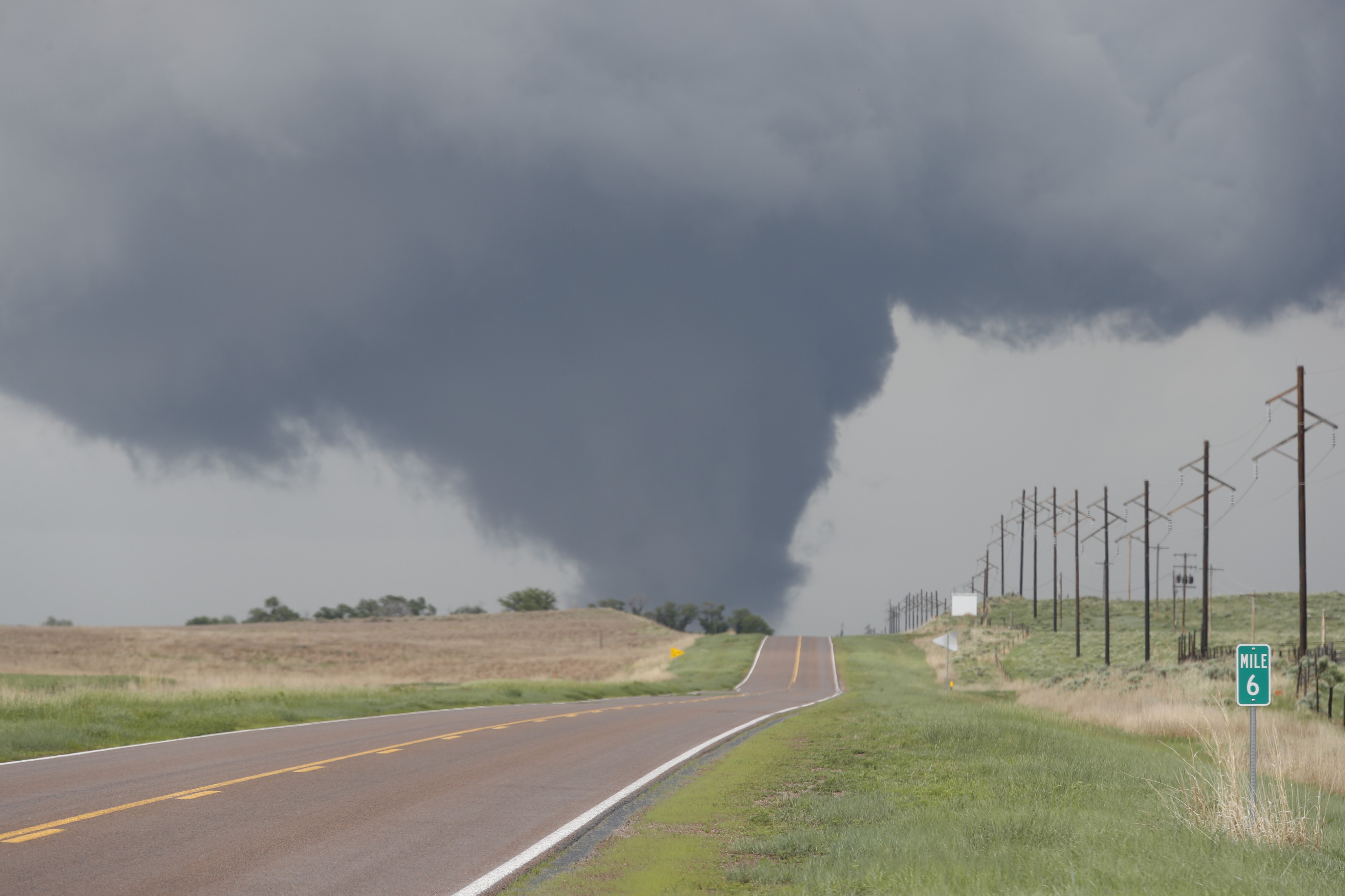
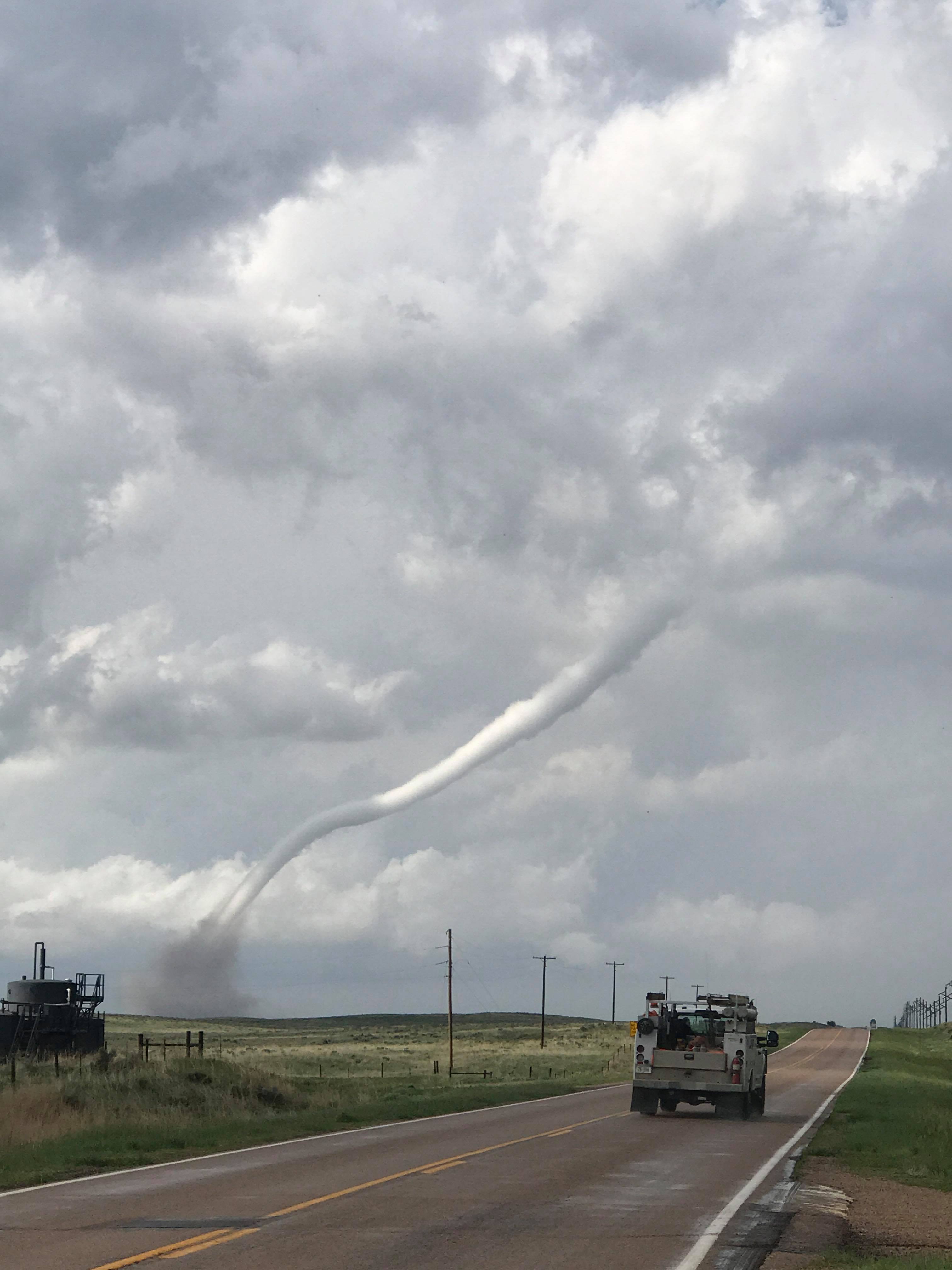
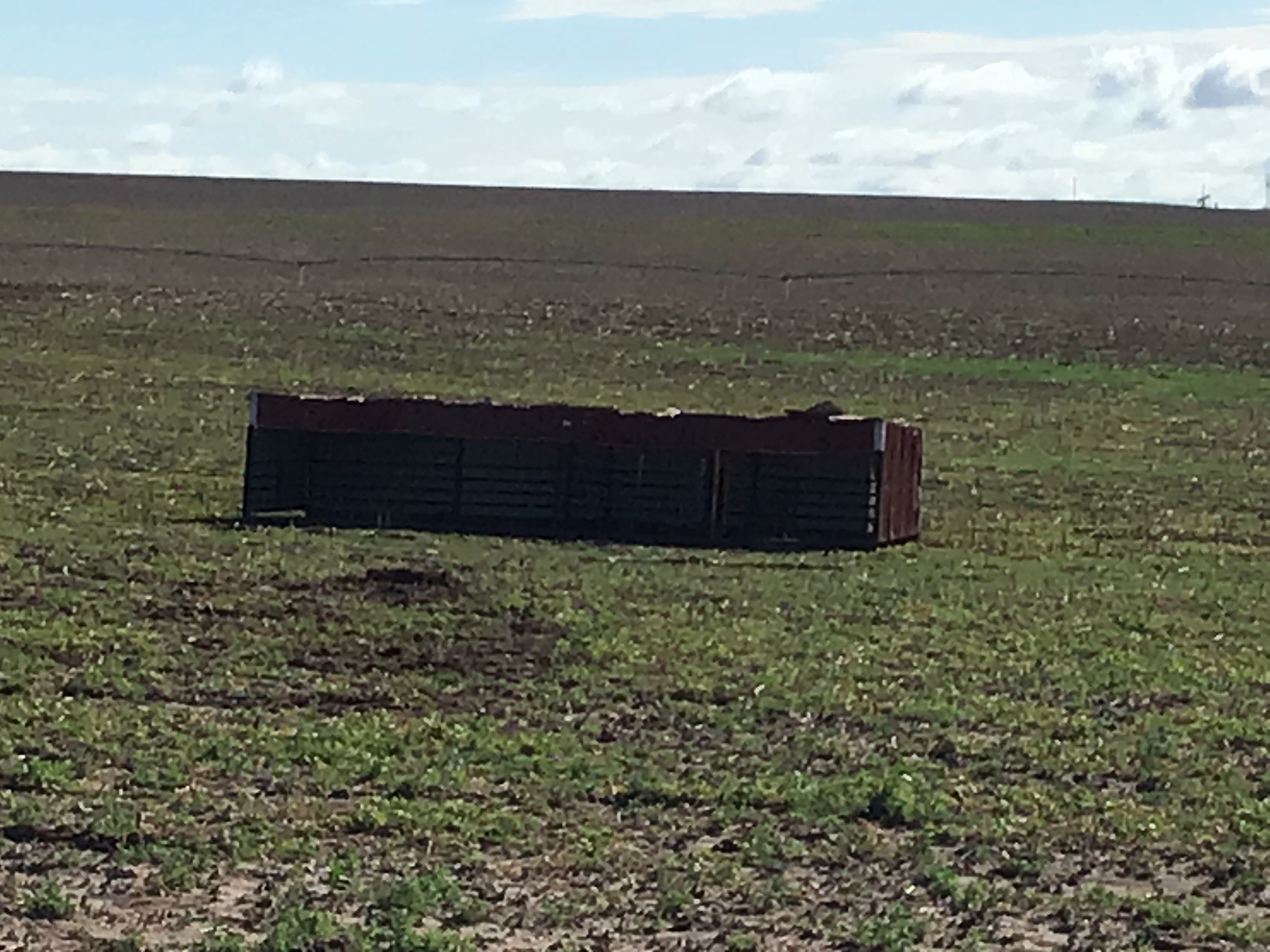
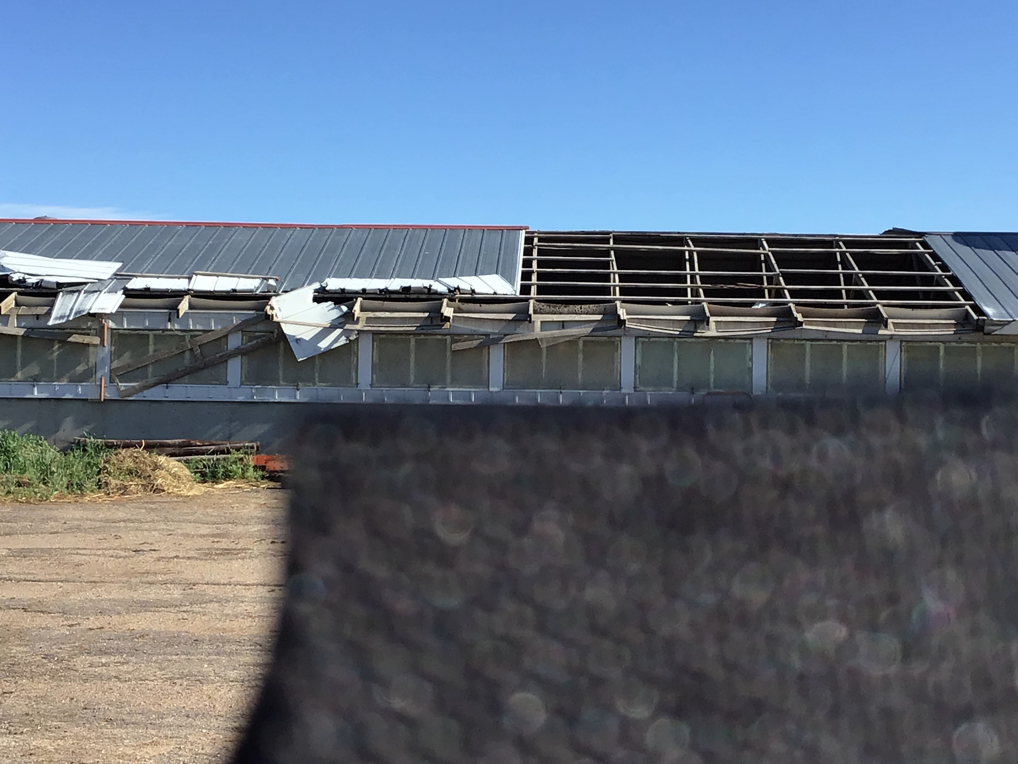
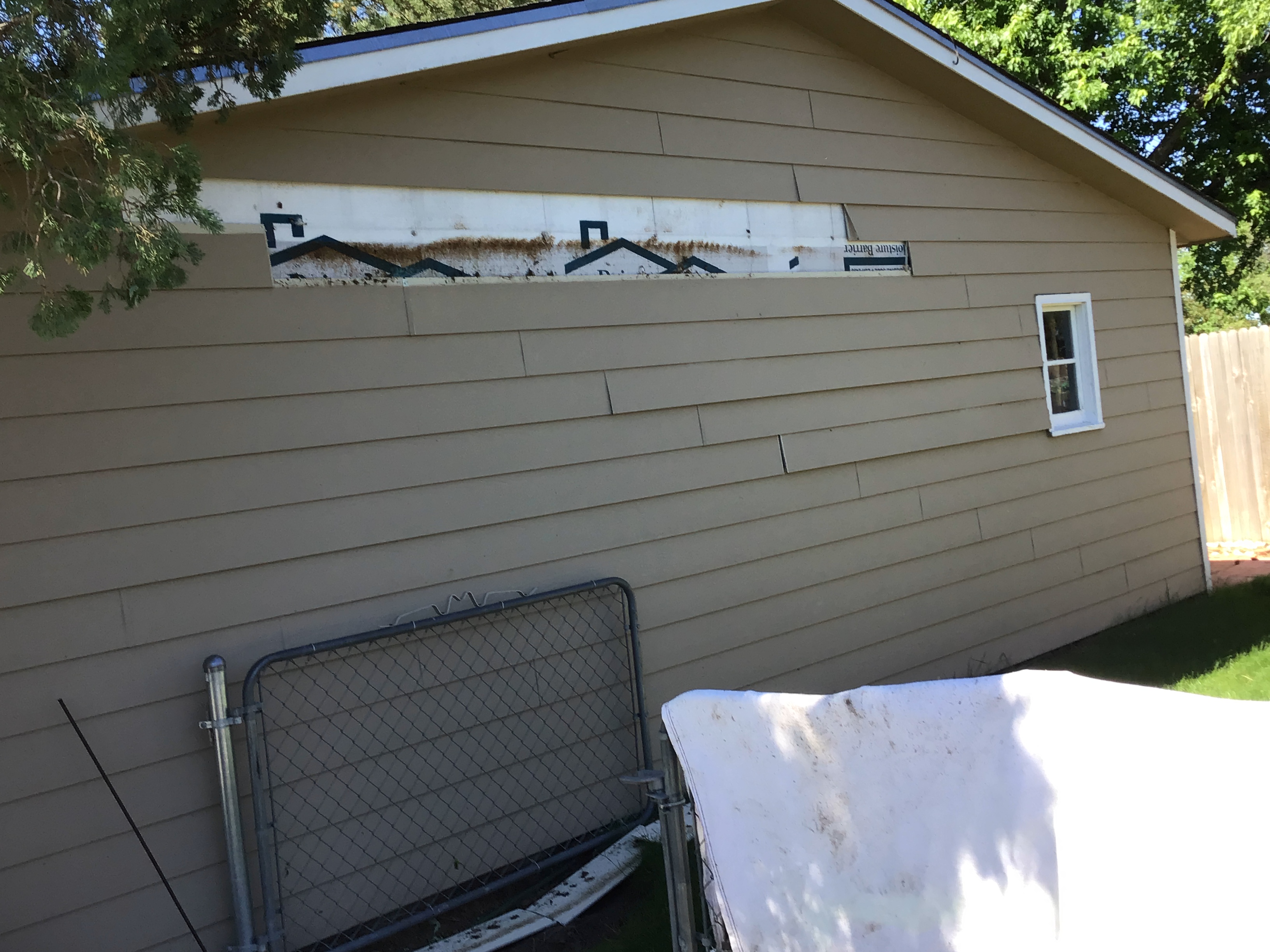
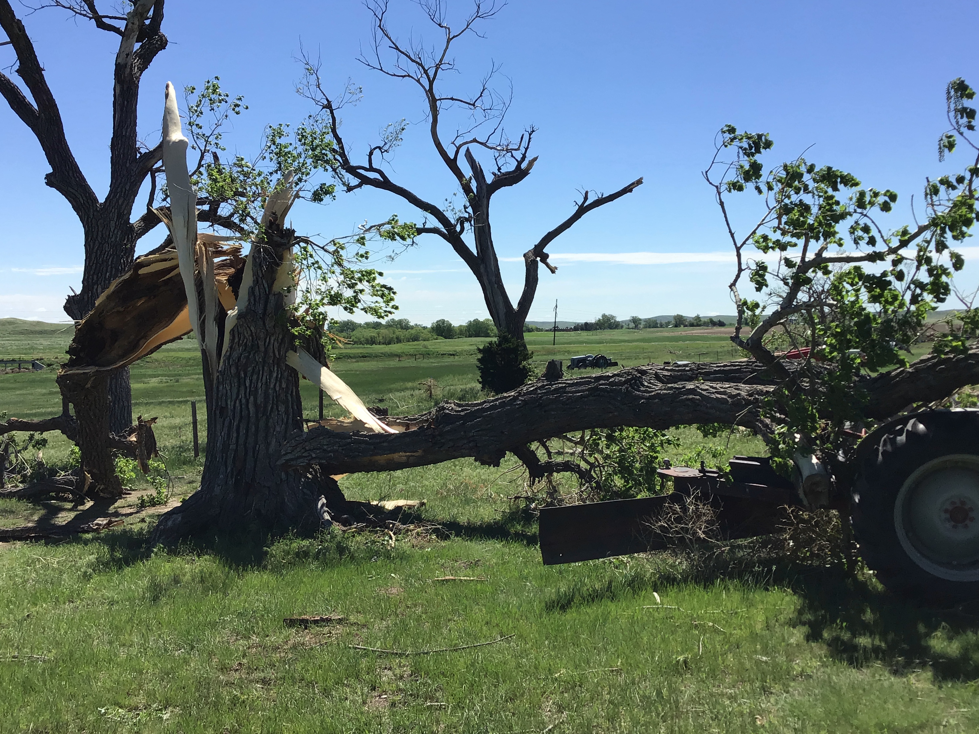
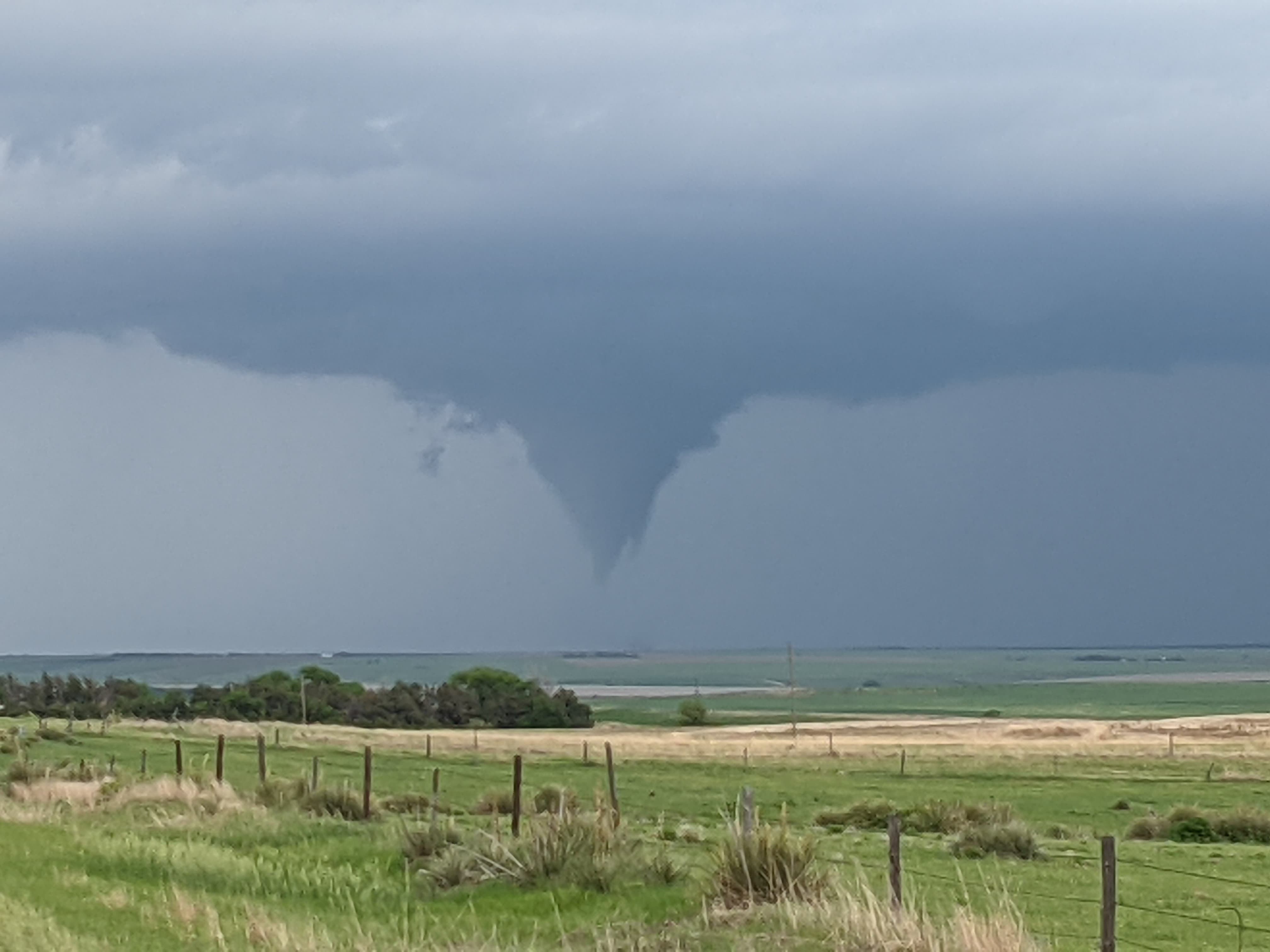
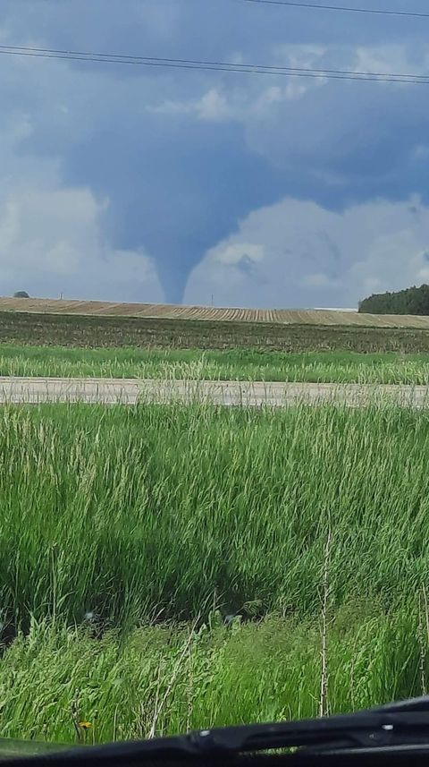
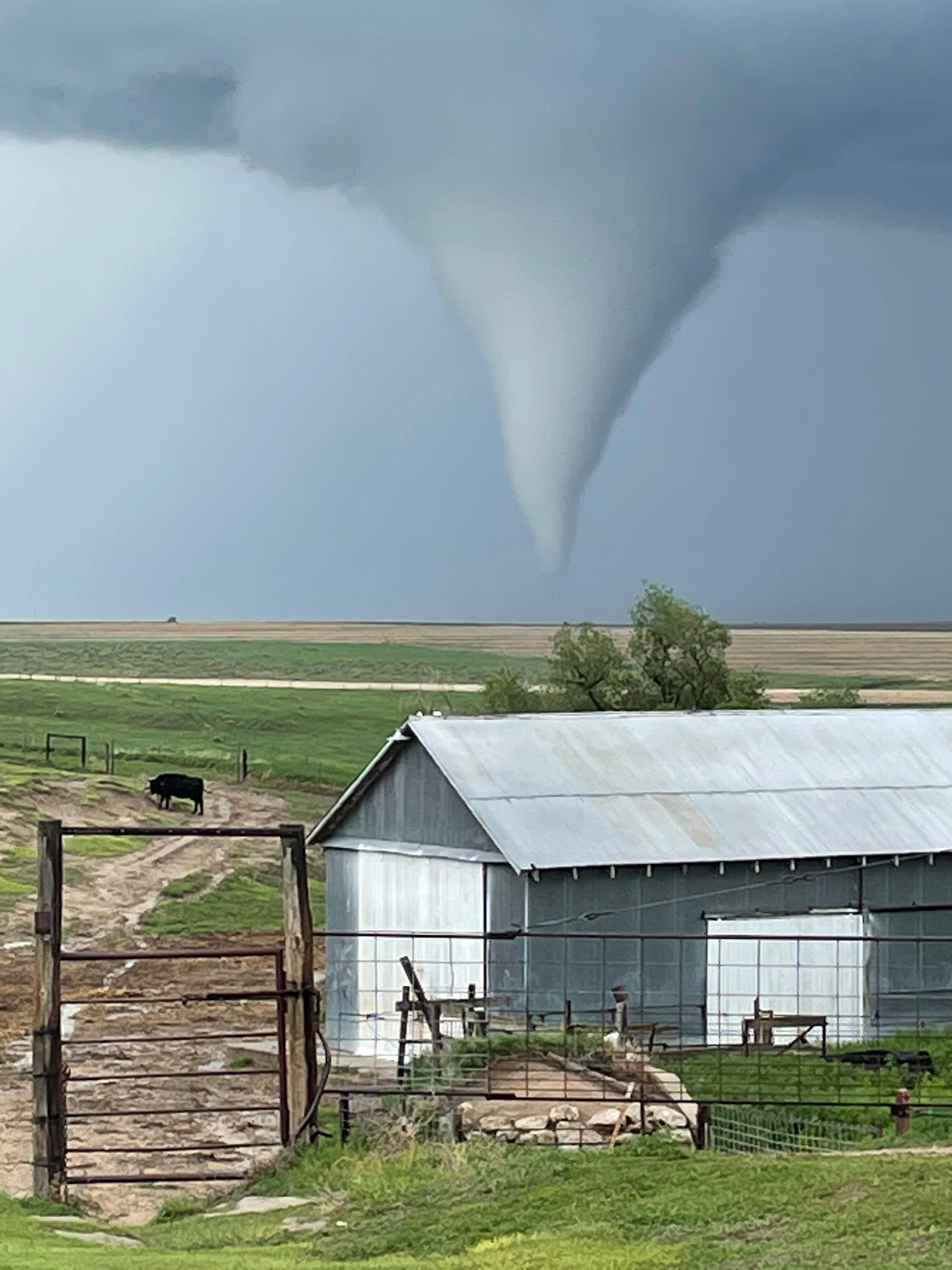
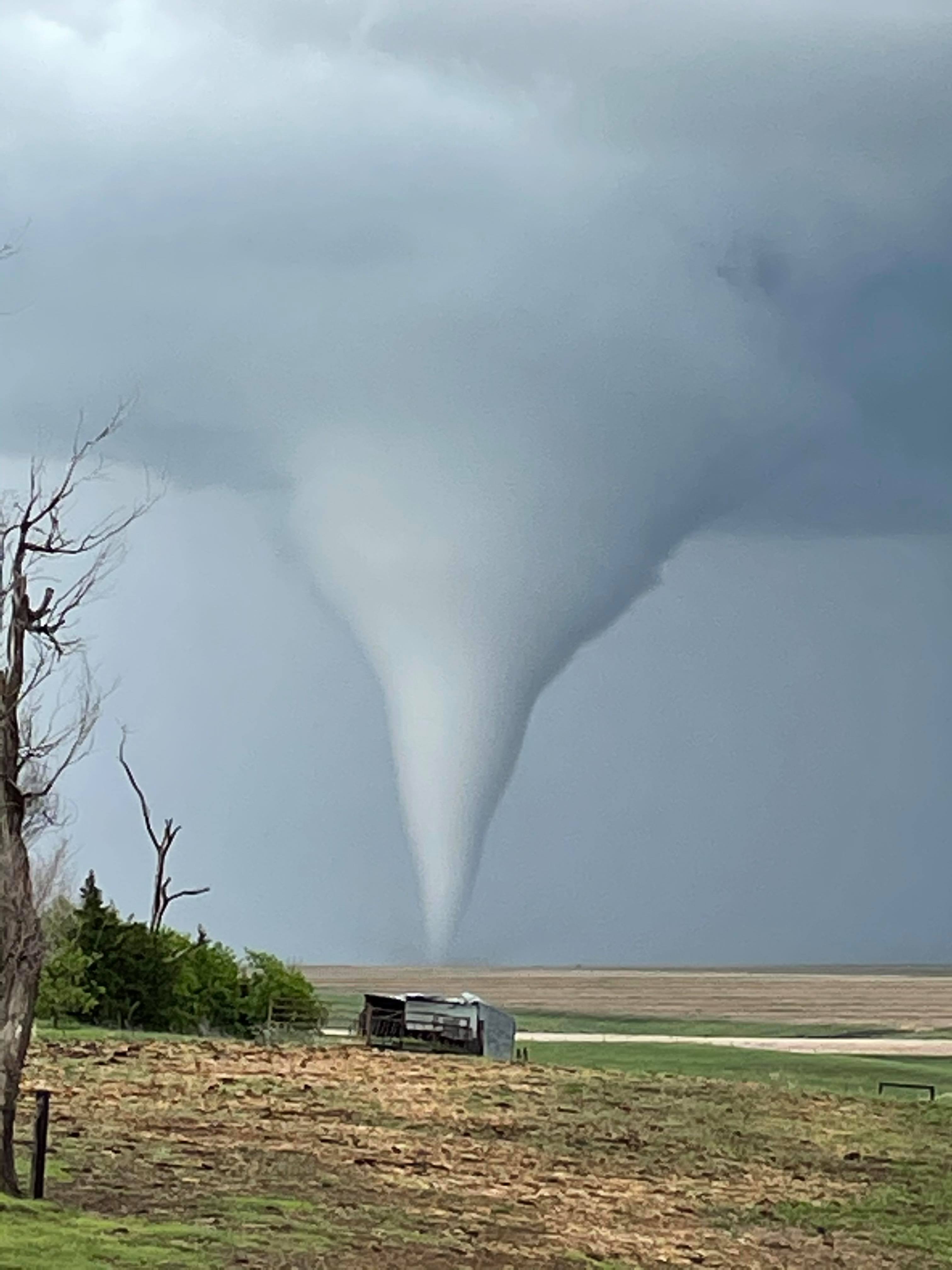
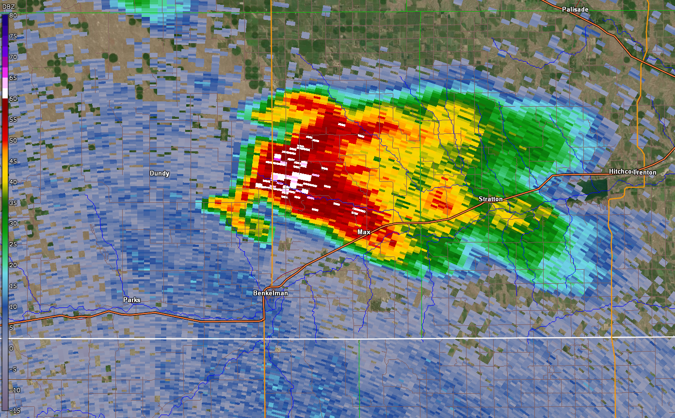
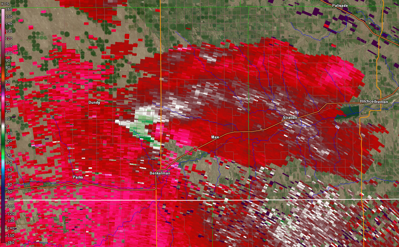
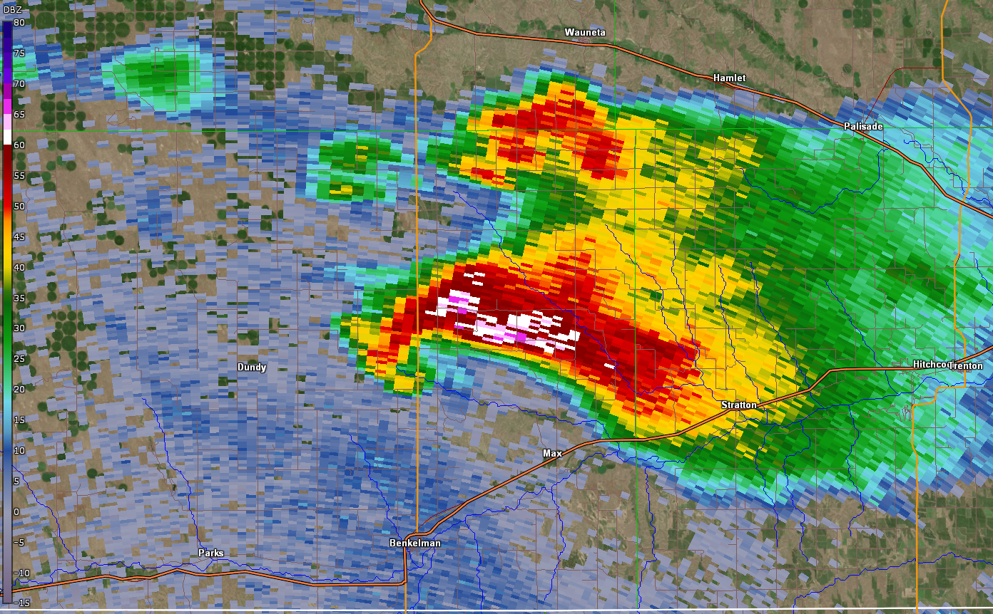
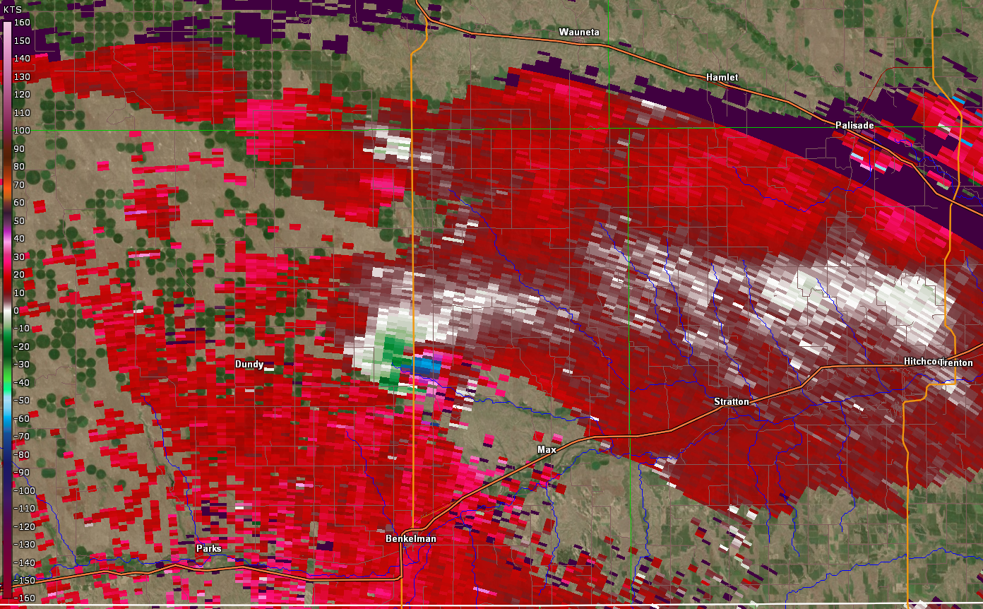
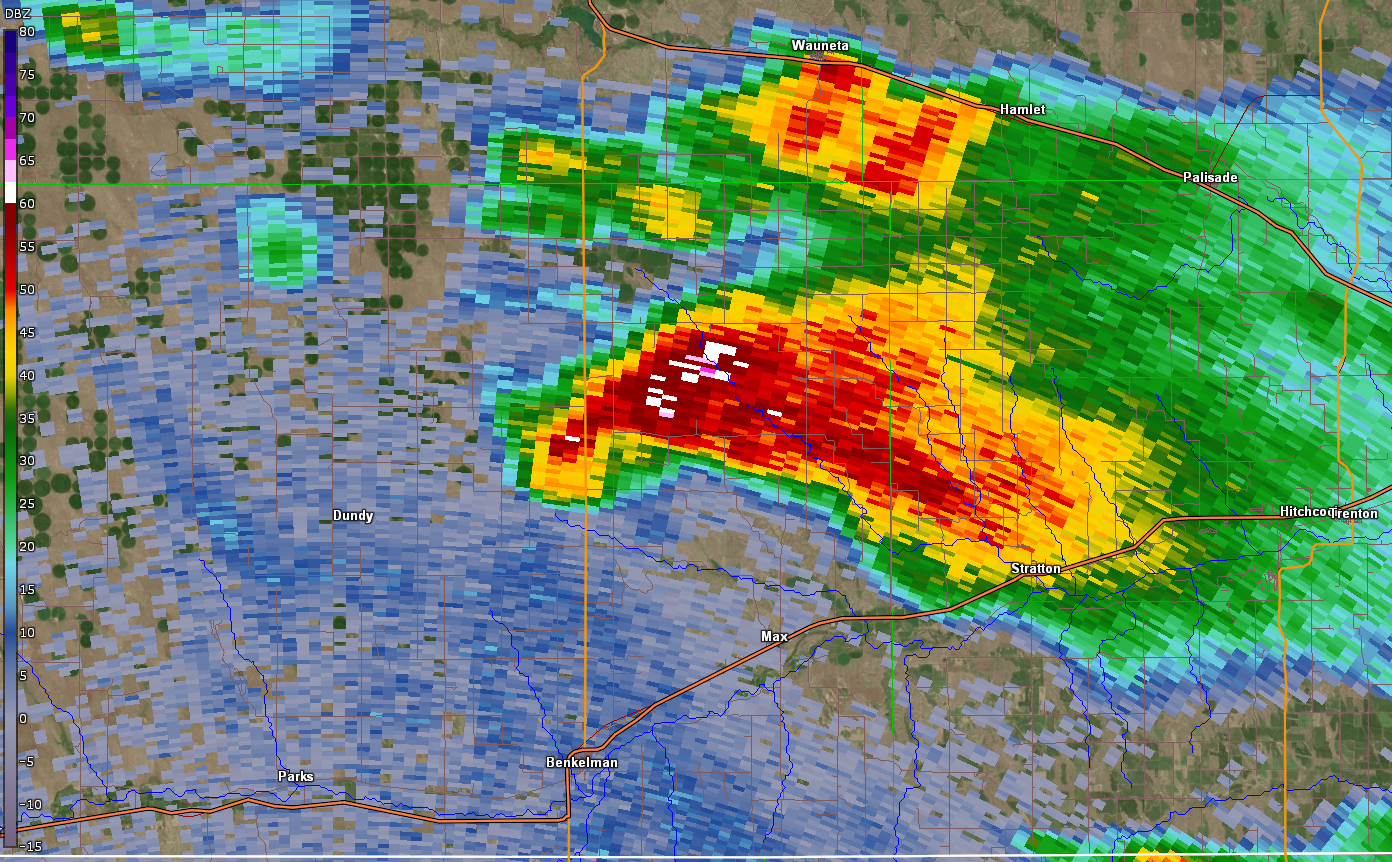
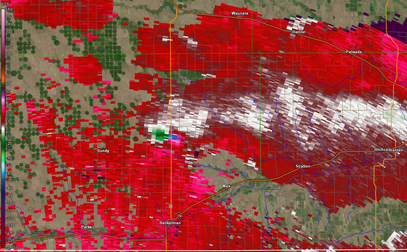
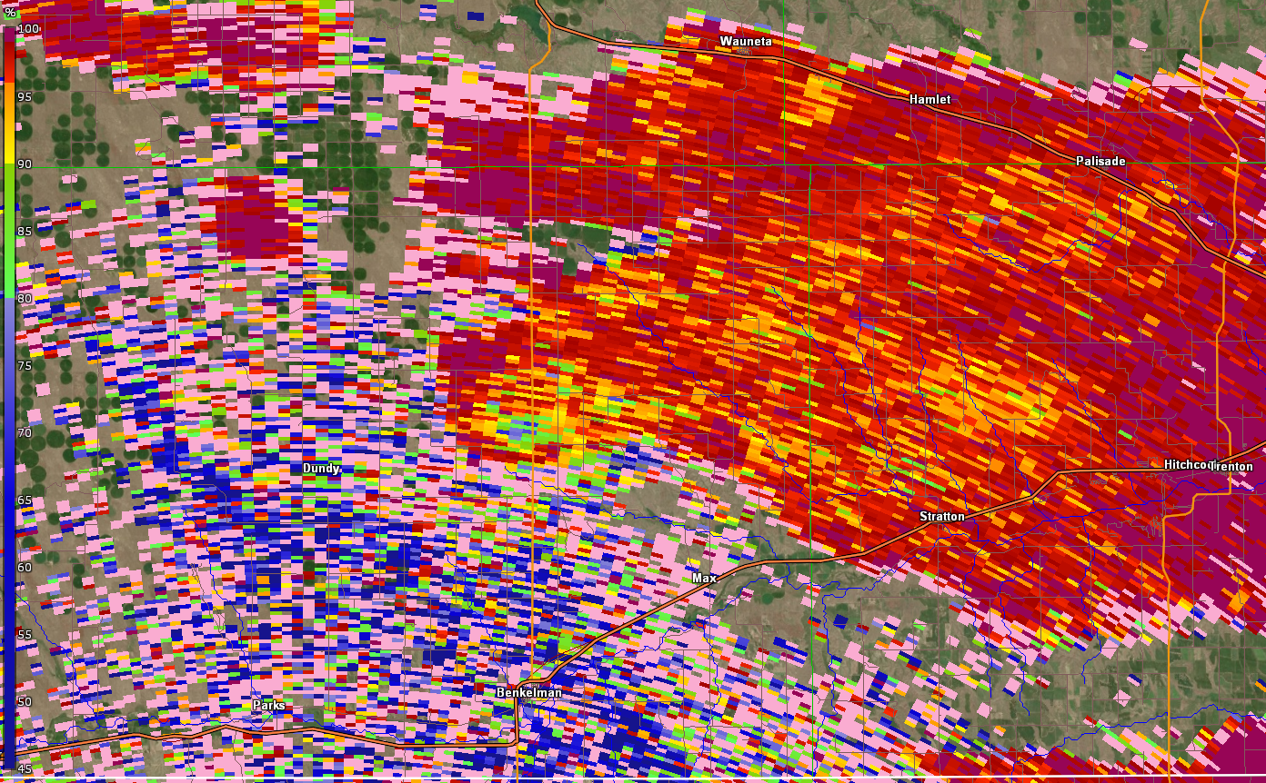
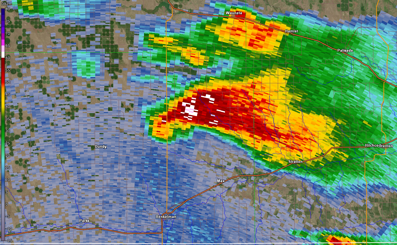
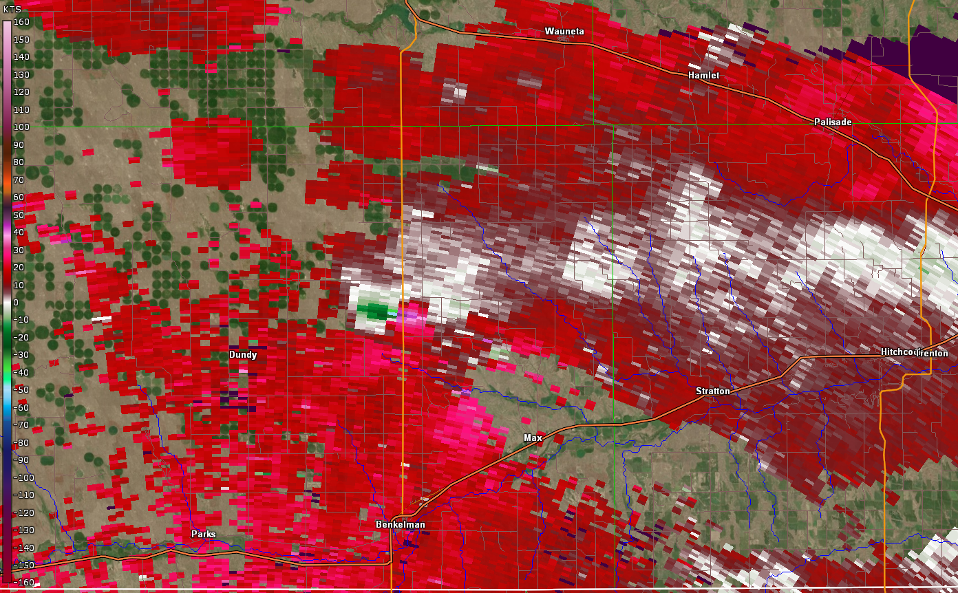
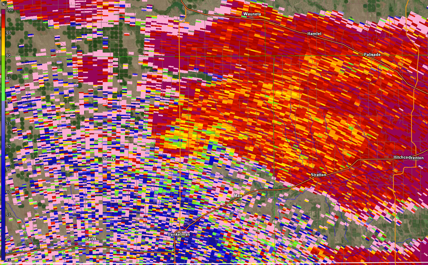
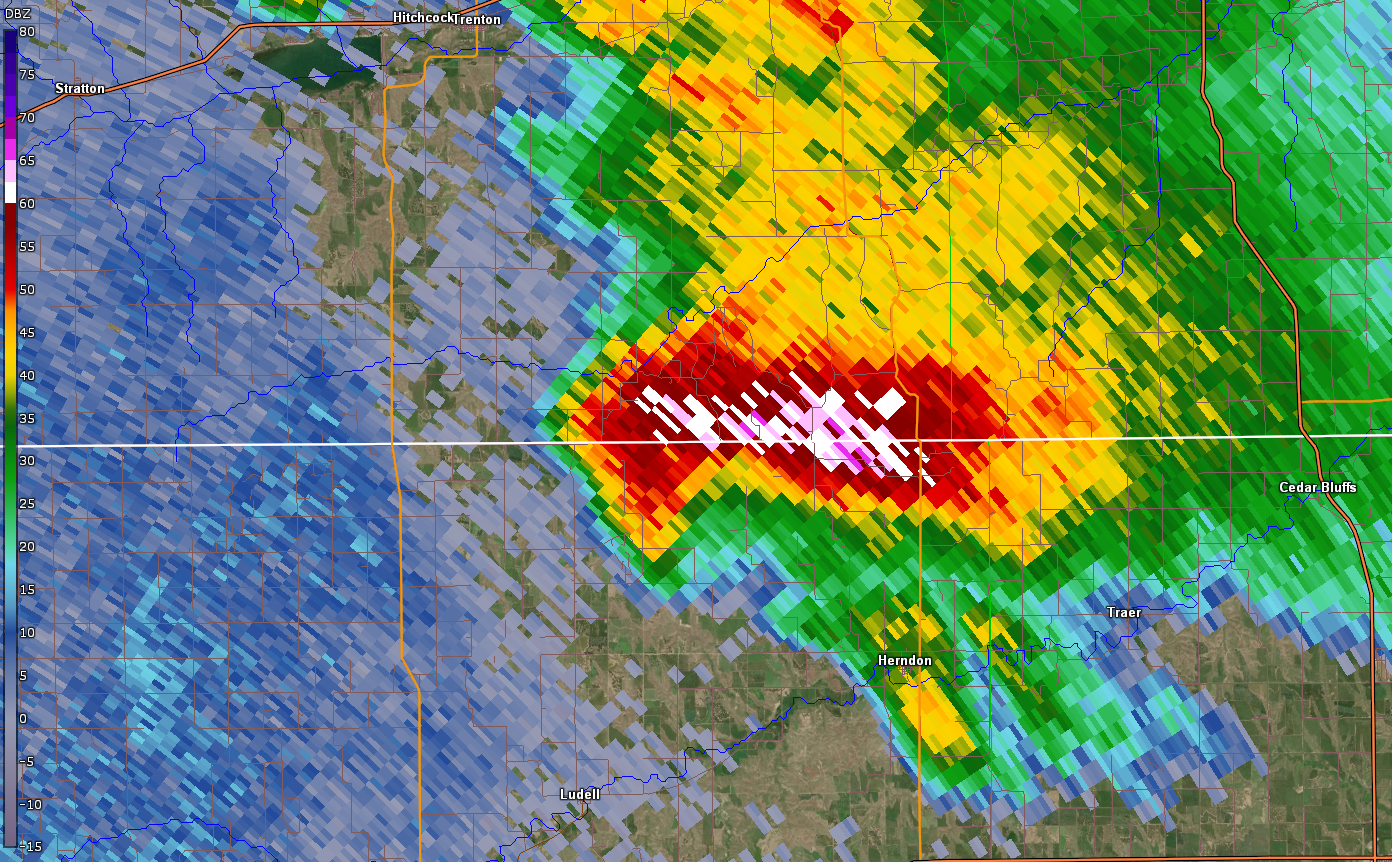
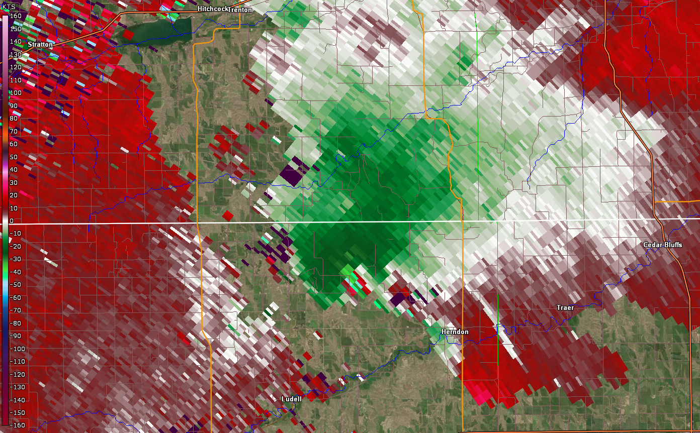
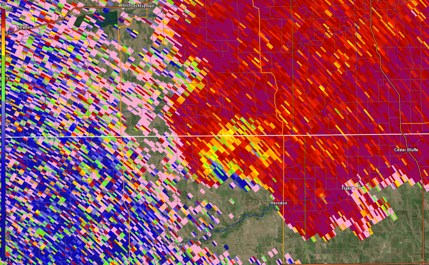
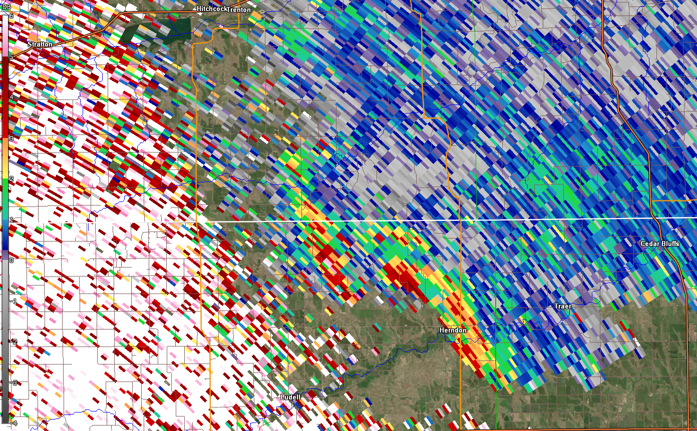
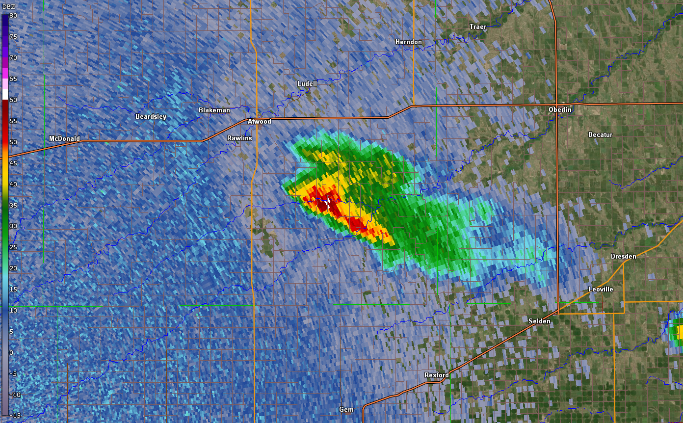
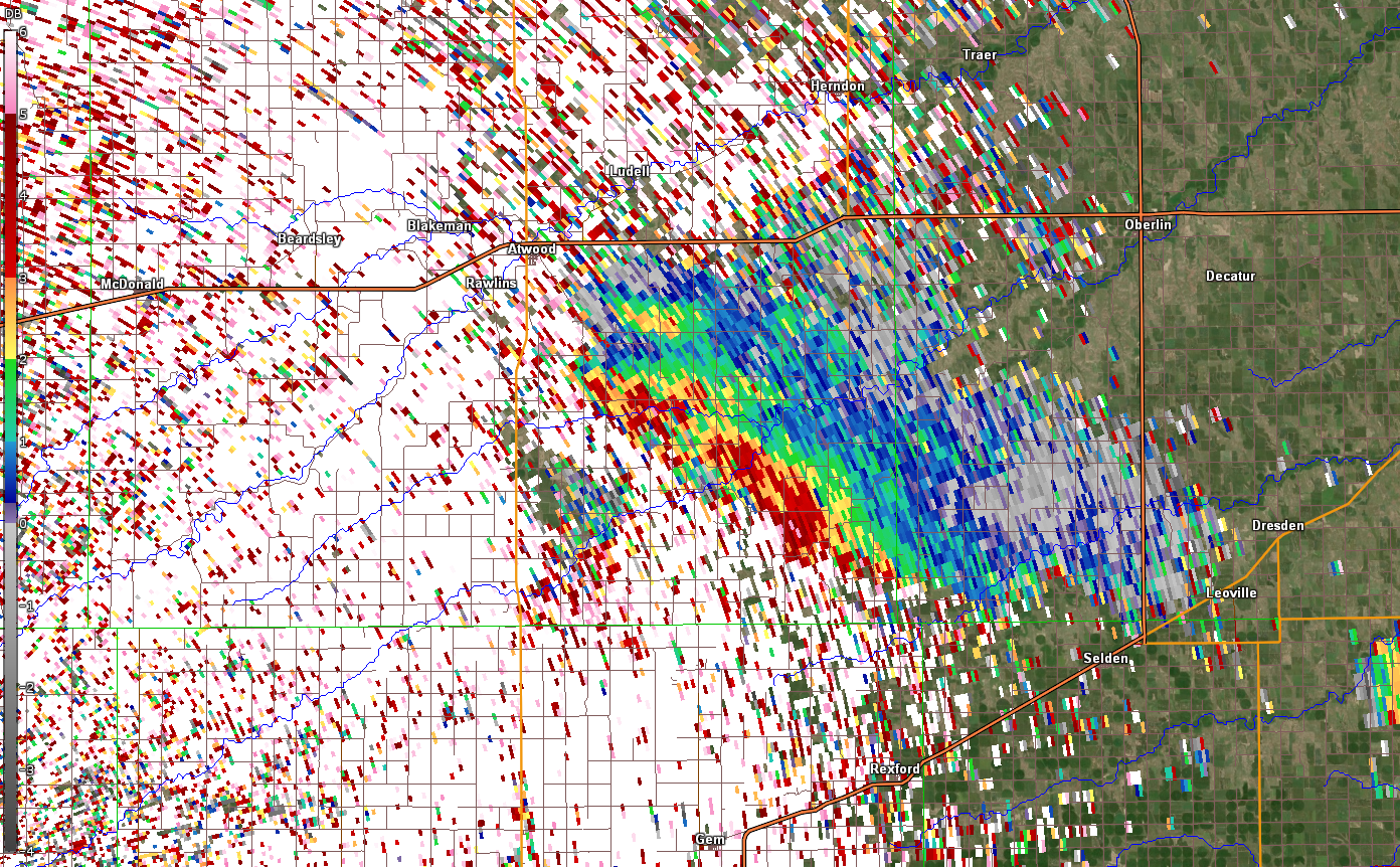
A second round of thunderstorms developed during the afternoon and evening hours. Severe storms initiated near the Nebraska border where a warm front was draped. These supercells not only produced large hail but multiple tornadoes. NWS Survey Teams were able to find damage caused by three separate tornadoes. At 3:25 PM MT, a tornado touched down 5 north of Benkelman, NE and tracked northward, resulting in damage to a shed, metal roofing, and fencing (Benkelman 1). Shortly after this tornado lifted, a second tornado began 7 north of Benkelman, NE at 3:39 PM MT and lasted 20 minutes, traveling northward (Benkelman 2). It caused the most significant damage of the day as it moved along Highway 61 for most of its life. The third tornado began at 5:29 PM CDT at 7 west-northwest of Herndon, KS, tracking along County Road 27 and County Road 29 before lifting at 5:45 PM CDT. Thunderstorms increased in coverage near the Nebraska border through the evening hours as another line of storms progressed east through northeastern Colorado. This line of storms merged with existing storms out ahead, finally exiting the region to the east overnight.
Tornadoes:
|
Tornado - Benkelman 1
|
||||||||||||||||
|
Tornado - Benkelman 2
|
||||||||||||||||
|
Tornado - Herndon
|
||||||||||||||||
The Enhanced Fujita (EF) Scale classifies tornadoes into the following categories:
| EF0 Weak 65-85 mph |
EF1 Moderate 86-110 mph |
EF2 Significant 111-135 mph |
EF3 Severe 136-165 mph |
EF4 Extreme 166-200 mph |
EF5 Catastrophic 200+ mph |
 |
|||||
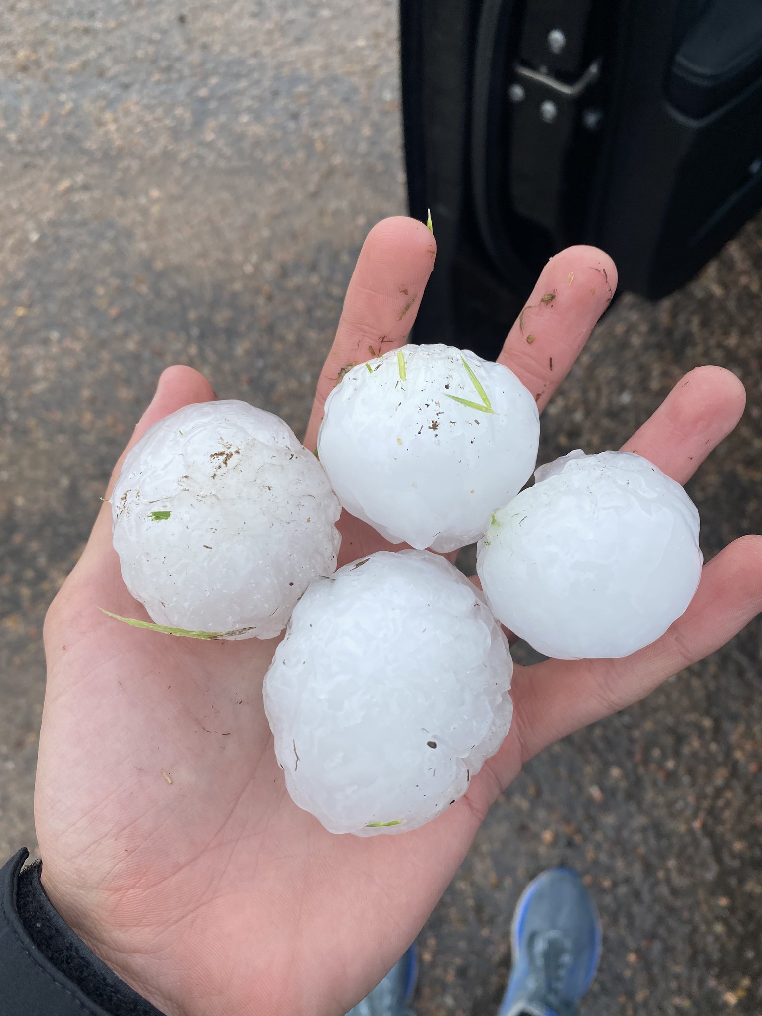
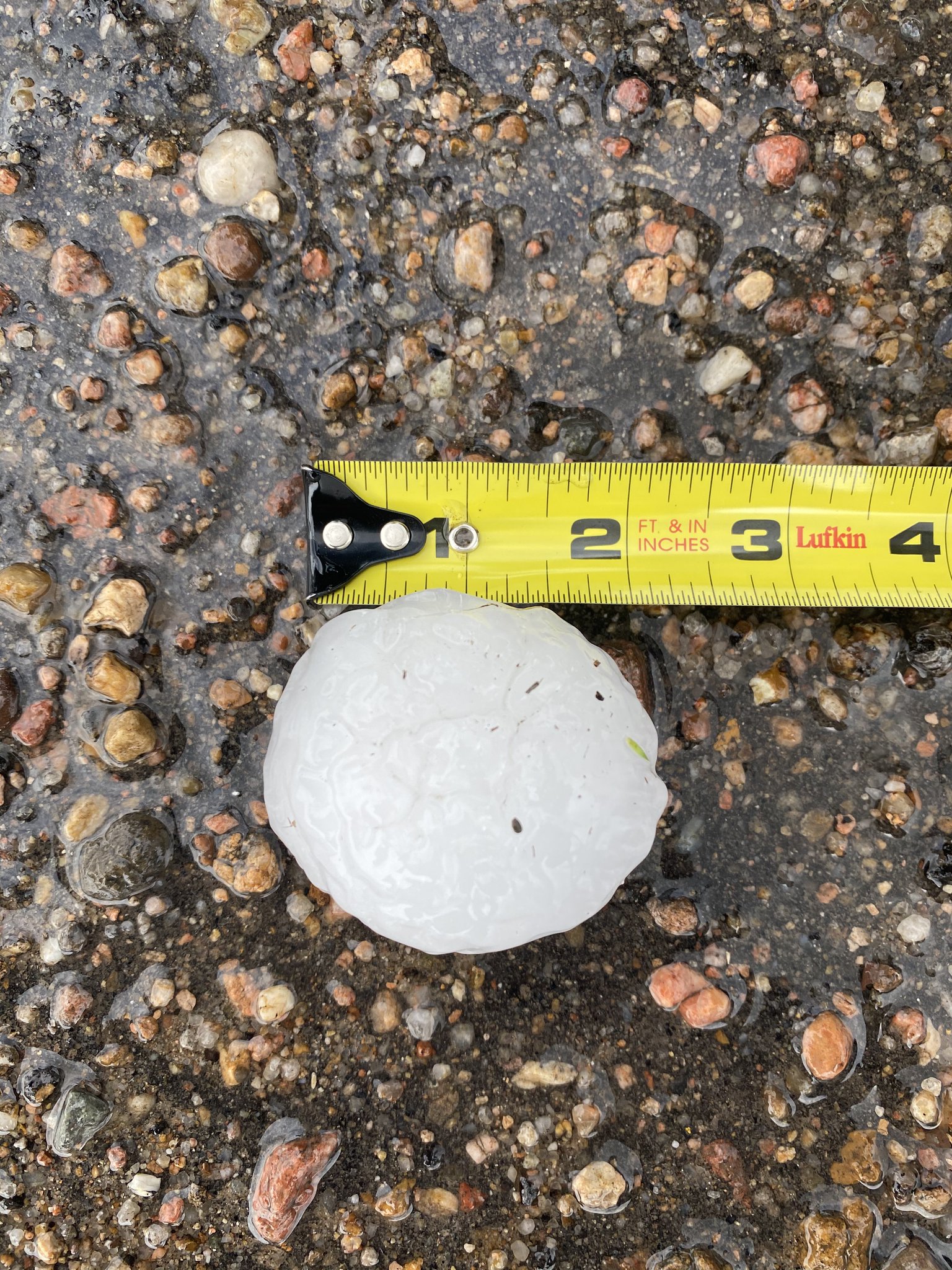
Hail:
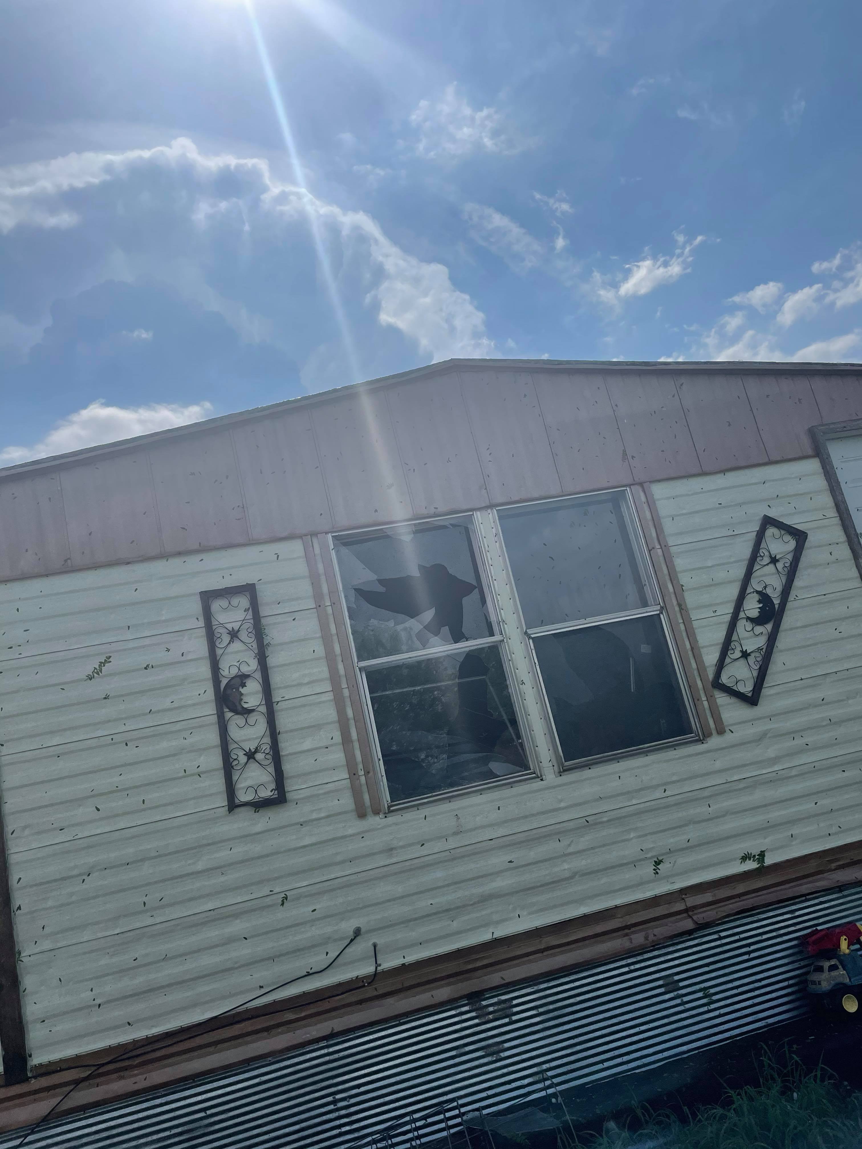
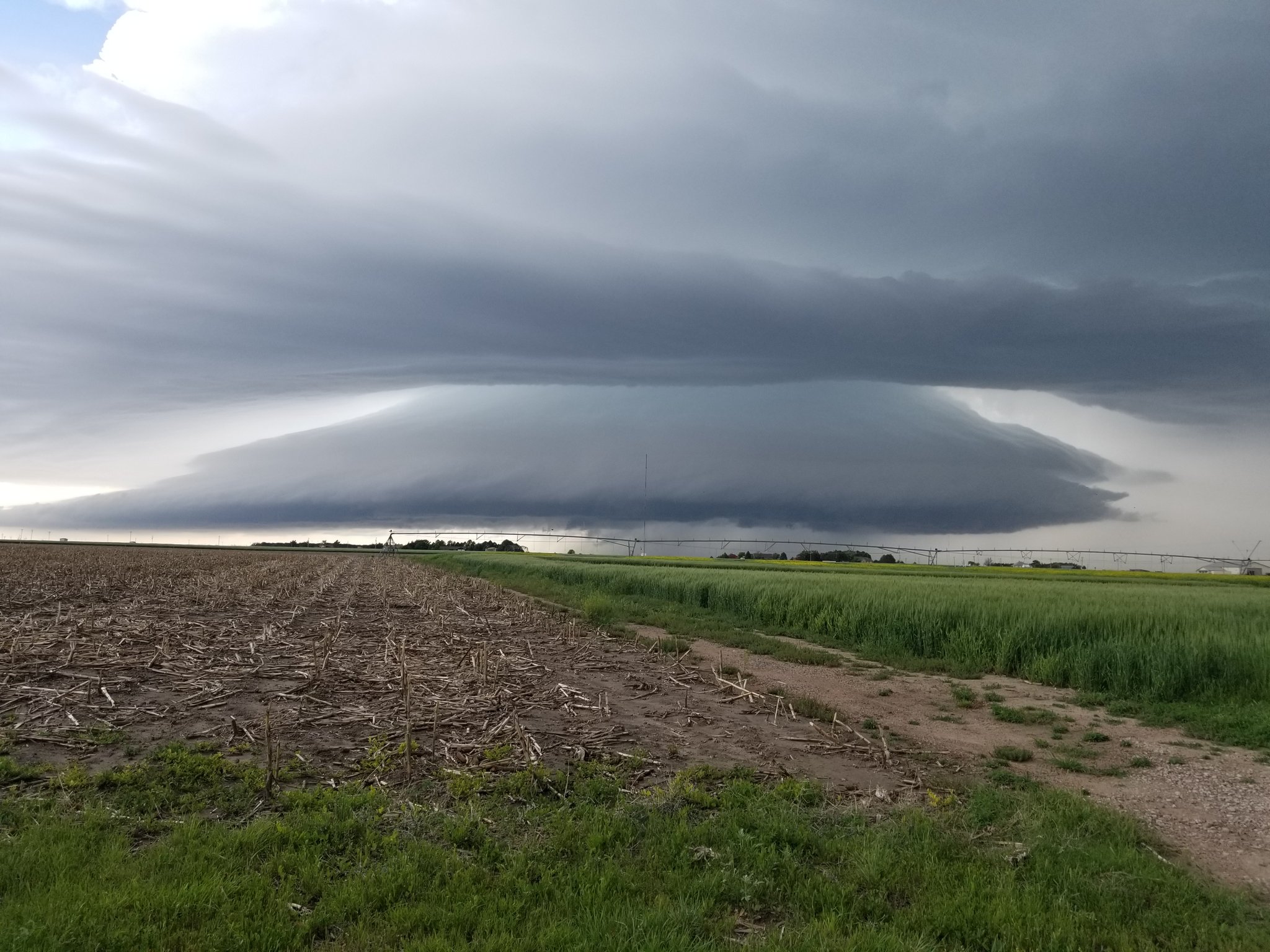
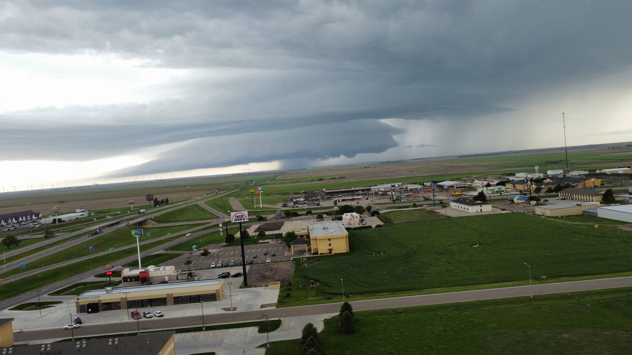
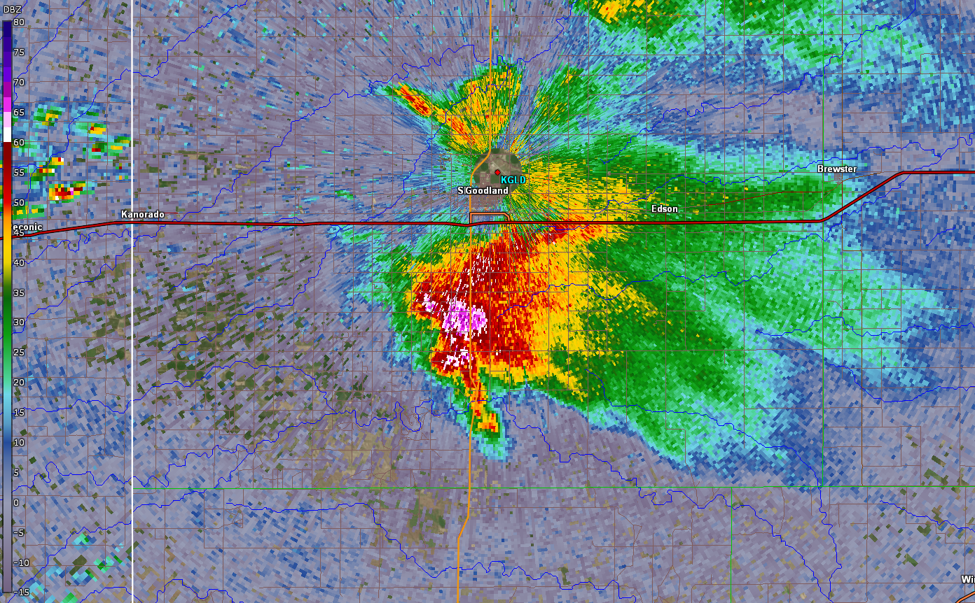
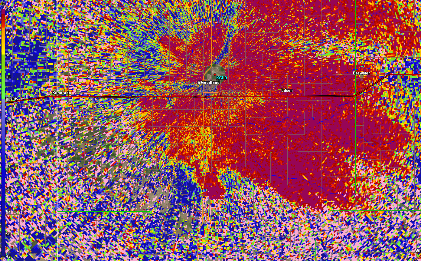
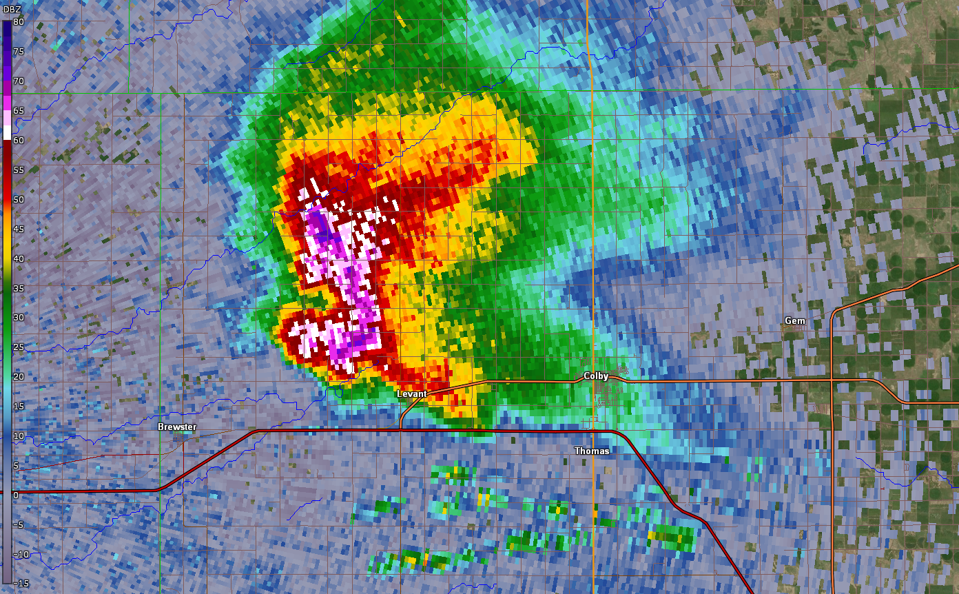
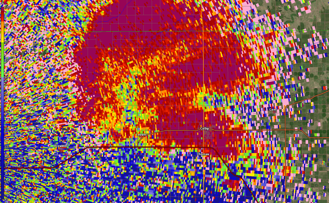
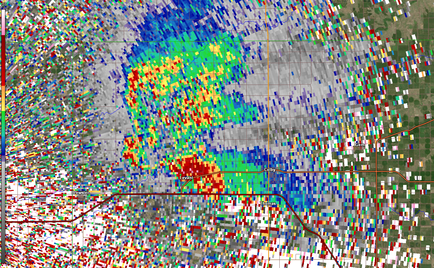
In addition to the tornadoes in the evening, severe thunderstorms were observed during the morning and early afternoon hours. One storm in particular dropped large hail across the central portion of the region.
(click image to enlarge)
 |
 |
 |
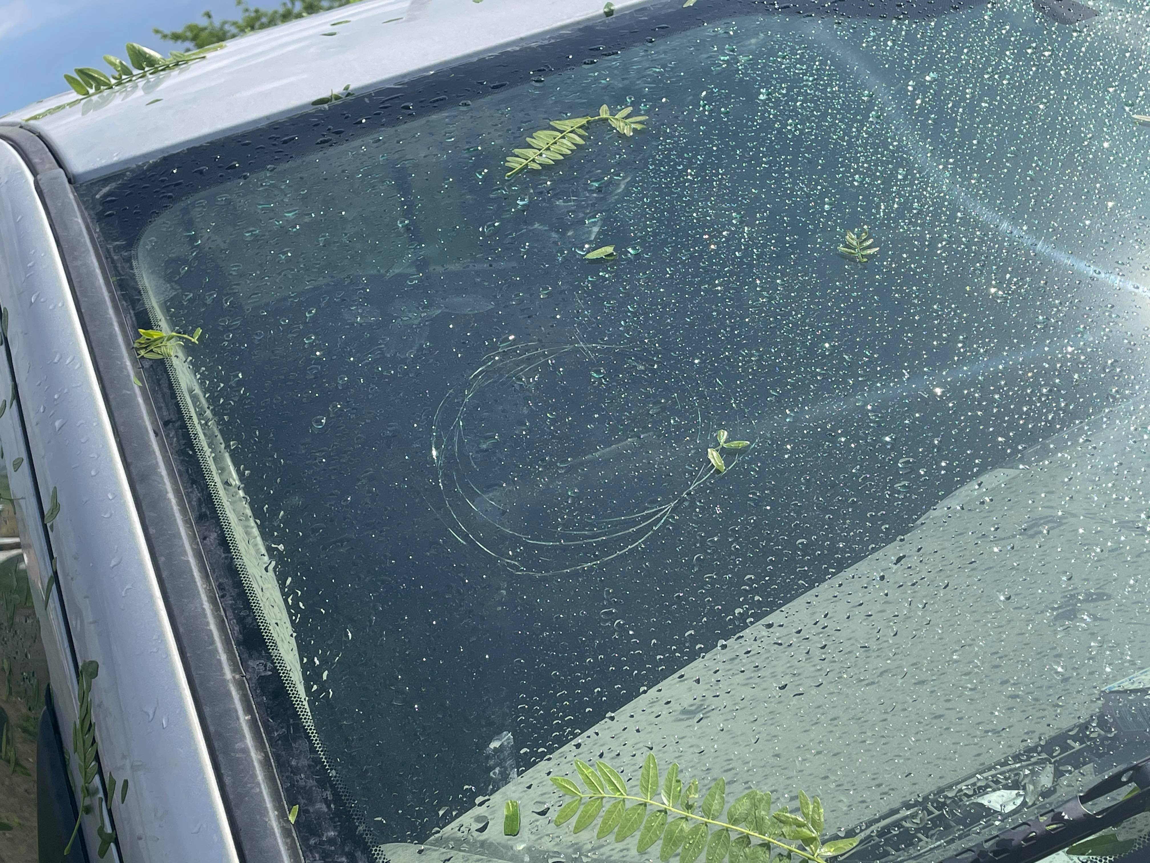 |
| Hail south of Goodland, KS. Courtesy of Adrienne Lynn West. | Hail south of Goodland, KS. Courtesy of Adrienne Lynn West. | Hail damage south of Goodland, KS. Courtesy of Adrienne Lynn West. | Hail damage south of Goodland, KS. Courtesy of Adrienne Lynn West. |
 |
 |
 |
 |
| Hail near Colby, KS. Courtesy of Hunter Goodrich. | Hail near Colby, KS. Courtesy of Thomas Knepshield. | Hail near Colby, KS. Courtesy of Thomas Knepshield. | Hail 7 miles north of Colby, KS. Courtesy of Kasey Griffith. |
 |
 |
 |
 |
| Morning supercell near Gem, KS. Courtesy of Ray Duffey. | View of morning supercell from Colby, KS. Courtesy of Sidney Aaron Grimmett. | Morning supercell. Courtesy of Jonathan Higerd. | Morning storm at Colby, KS. Courtesy of Jennifer Sterrett Lindbergh. |
Photos & Video
(click image to enlarge)
 |
 |
 |
 |
| Tornado near Benkelman, NE. Courtesy of Jason Frederick. | Tornado near Benkelman, NE. Courtesy of Jason Frederick. | Tornado near Benkelman, NE. Courtesy of Jason Frederick. | Tornado near Benkelman, NE. Courtesy of Jason Frederick. |
 |
 |
 |
 |
| NWS Damage Survey. Benkelman 1 Tornado. |
NWS Damage Survey. Benkelman 1 Tornado. |
NWS Damage Survey. Benkelman 1 Tornado. |
NWS Damage Survey. Benkelman 1 Tornado. |
 |
 |
 |
 |
| NWS Damage Survey. Benkelman 2 Tornado. |
NWS Damage Survey. Benkelman 2 Tornado. |
NWS Damage Survey. Benkelman 2 Tornado. |
NWS Damage Survey. Benkelman 2 Tornado. |
 |
 |
 |
 |
| Tornado near Herndon, KS. Courtesy of Matt Sellers |
Tornado near Herndon, KS. Courtesy of Matt Sellers |
Tornado near Herndon, KS. Courtesy of Laurie Kastens. |
Tornado near Herndon, KS. Courtesy of Laurie Kastens |
 |
 |
 |
 |
| NWS Damage Survey. Herndon Tornado. |
NWS Damage Survey. Herndon Tornado. |
NWS Damage Survey. Herndon Tornado. |
NWS Damage Survey. Herndon Tornado. |
|
|
Radar
(click image to enlarge)
 |
 |
 |
| Radar Reflectivity for Morning Supercell Producing Baseball Size Hail. Storm south of Goodland. | Radar Correlation Coefficient for Morning Supercell Producing Baseball Size Hail. Storm south of Goodland. | Radar Differential Reflectivity for Morning Supercell Producing Baseball Size Hail. Storm south of Goodland. |
 |
 |
 |
| Radar Reflectivity for Morning Supercell Producing Tennis Ball Size Hail. Storm north of Brewster. | Radar Correlation Coefficient for Morning Supercell Producing Tennis Ball Size Hail. Storm north of Brewster. | Radar Differential Reflectivity for Morning Supercell Producing Tennis Ball Size Hail. Storm north of Brewster. |
 |
 |
 |
| Radar Reflectivity for Morning Supercell Producing Ping Pong Ball Size Hail. Storm north of Colby. | Radar Correlation Coefficient for Morning Supercell Producing Ping Pong Ball Size Hail. Storm north of Colby. | Radar Differential Reflectivity for Morning Supercell Producing Ping Pong Ball Size Hail. Storm north of Colby. |
 |
 |
 |
 |
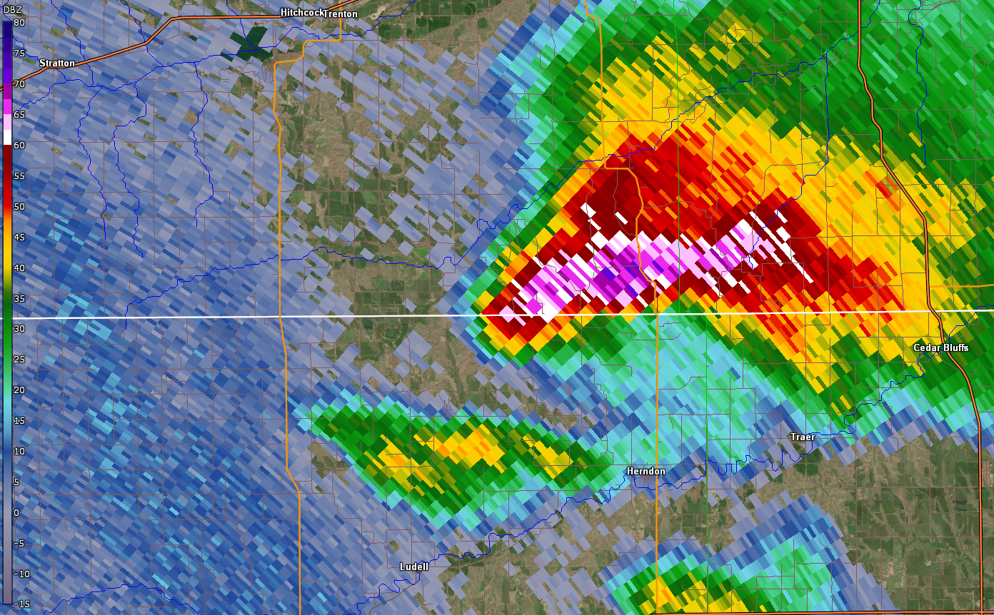
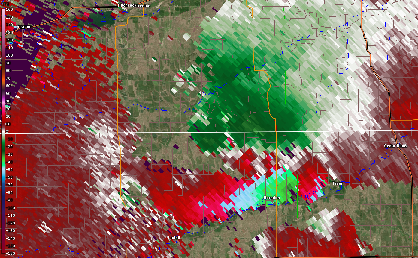
| Radar Reflectivity around the time of the EF-0 tornado north of Benkelman, NE. | Radar Storm Relative Velocity around the time of the EF-0 tornado north of Benkelman, NE. | Radar Reflectivity around the start time of the EF-2 tornado north of Benkelman, NE. | Radar Storm Relative Velocity around the start time of the EF-2 tornado north of Benkelman, NE. |
 |
 |
 |
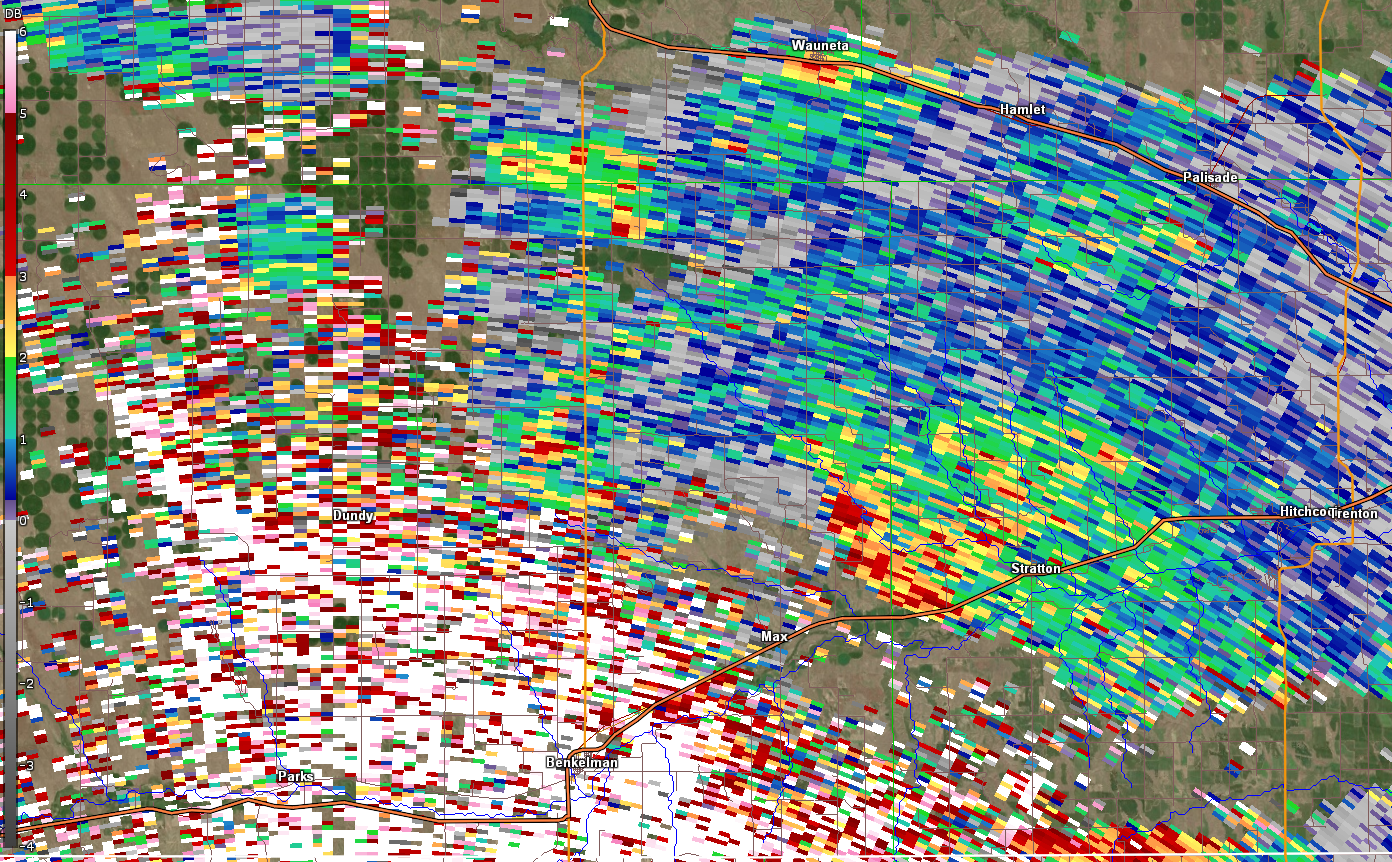 |
| Damaging EF-2 tornado ongoing north of Benkelman, NE. Debris visible to radar imagery. | Damaging EF-2 tornado ongoing north of Benkelman, NE. Debris visible to radar imagery. | Damaging EF-2 tornado ongoing north of Benkelman, NE. Debris visible to radar imagery. | Damaging EF-2 tornado ongoing north of Benkelman, NE. Debris visible to radar imagery. |
 |
 |
 |
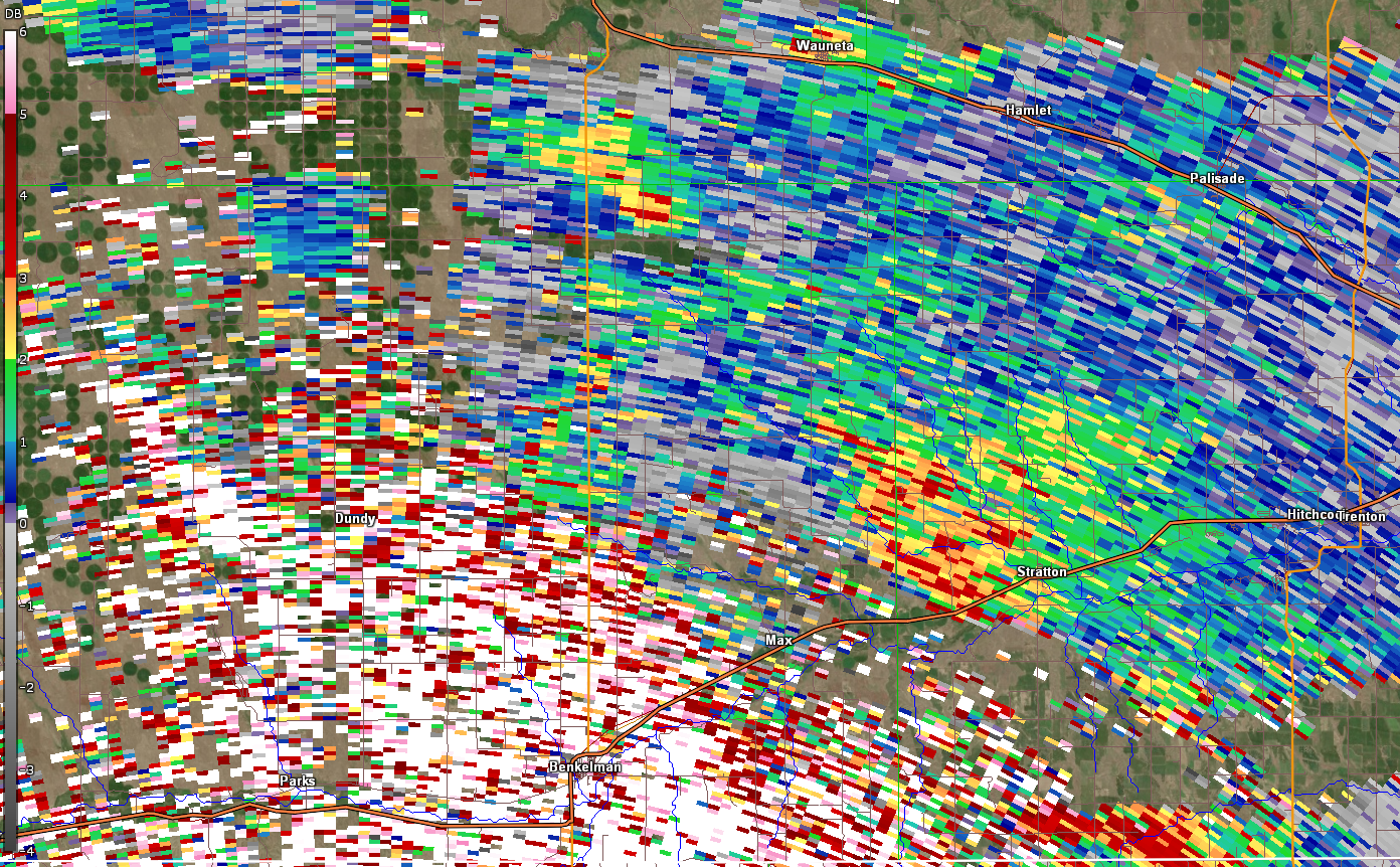 |
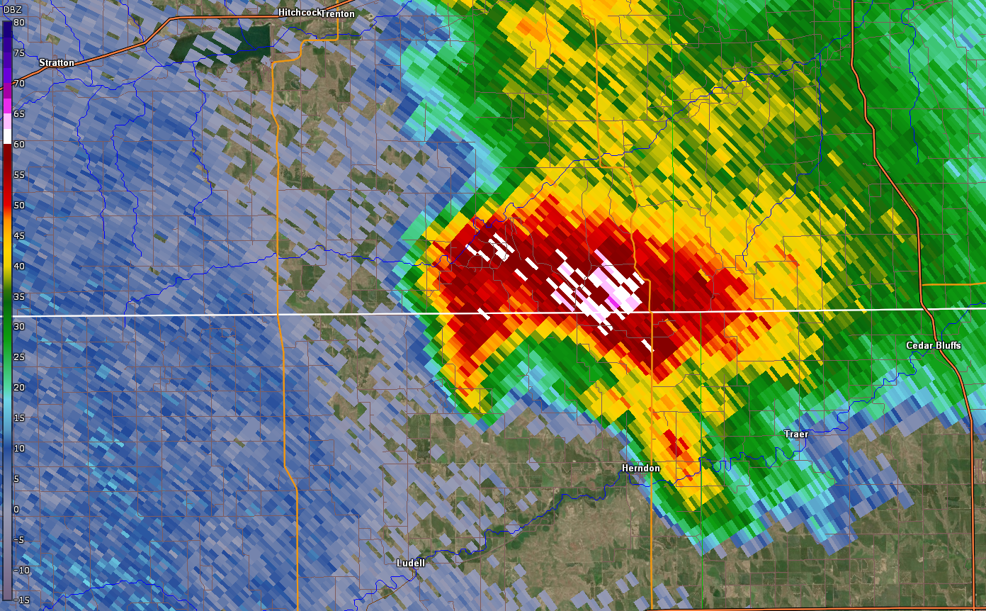
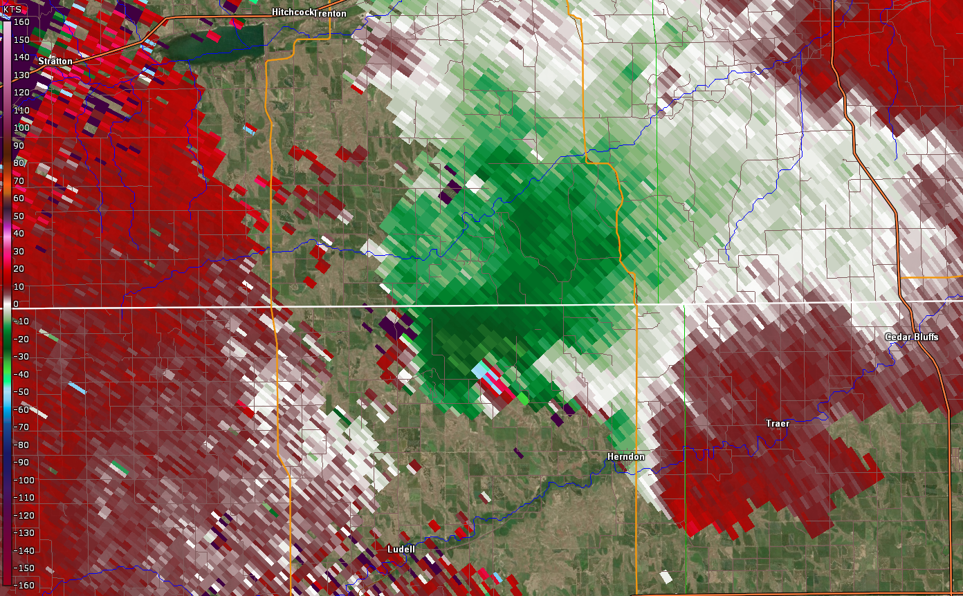
| Radar Reflectivity around the beginning of the Herndon, KS tornado. | Radar Storm Relative Velocity around the beginning of the Herndon, KS tornado. | Radar Reflectivity around the end of the Herndon, KS tornado. | Radar Storm Relative Velocity around the end of the Herndon, KS tornado. |
 |
 |
 |
 |
| Damaging EF-1 tornado ongoing northwest of Herndon, KS. Debris visible to radar imagery. | Damaging EF-1 tornado ongoing northwest of Herndon, KS. Debris visible to radar imagery. | Damaging EF-1 tornado ongoing northwest of Herndon, KS. Debris visible to radar imagery. | Damaging EF-1 tornado ongoing northwest of Herndon, KS. Debris visible to radar imagery. |
 |
 |
 |
| Low precipitation supercell during the evening hours. Image shows reflectivity at 6:29 PM MT. | Low precipitation supercell during the evening hours. Image shows differential reflectivity at 6:29 PM MT. | Low precipitation supercell during the evening hours. Image shows correlation coefficient at 6:29 PM MT. |
 |
 |
 |
| Low precipitation supercell during the evening hours. Image shows reflectivity at 6:57 PM MT. | Low precipitation supercell during the evening hours. Image shows differential reflectivity at 6:57 PM MT. | Low precipitation supercell during the evening hours. Image shows differential reflectivity at 6:57 PM MT. |
Storm Reports
For a map of all preliminary storm reports, please see this website.
PRELIMINARY LOCAL STORM REPORT...SUMMARY
NATIONAL WEATHER SERVICE GOODLAND KS
547 PM MDT THU MAY 27 2021
..TIME... ...EVENT... ...CITY LOCATION... ...LAT.LON...
..DATE... ....MAG.... ..COUNTY LOCATION..ST.. ...SOURCE....
..REMARKS..
0847 AM HAIL 2 NNE GOODLAND 39.37N 101.70W
05/26/2021 M0.75 INCH SHERMAN KS OFFICIAL NWS OBS
0906 AM HAIL 10 NNW BREWSTER 39.51N 101.42W
05/26/2021 M1.25 INCH SHERMAN KS NWS EMPLOYEE
0910 AM HAIL 3 SSW GOODLAND 39.31N 101.73W
05/26/2021 E0.88 INCH SHERMAN KS PUBLIC
0912 AM HAIL 7 S GOODLAND 39.25N 101.73W
05/26/2021 M1.25 INCH SHERMAN KS PUBLIC
DELAYED REPORT.
0918 AM HAIL 5 S GOODLAND 39.28N 101.71W
05/26/2021 M2.50 INCH SHERMAN KS PUBLIC
DELAYED REPORT.
0926 AM HAIL 7 SSE GOODLAND 39.25N 101.65W
05/26/2021 M1.00 INCH SHERMAN KS TRAINED SPOTTER
0929 AM HAIL 2 SE GOODLAND 39.33N 101.69W
05/26/2021 U1.00 INCH SHERMAN KS PUBLIC
REPORT FROM MPING: QUARTER (1.00 IN.).
0930 AM HAIL 2 SSW GOODLAND 39.32N 101.73W
05/26/2021 E1.00 INCH SHERMAN KS NWS EMPLOYEE
1008 AM HAIL 2 S BREWSTER 39.34N 101.37W
05/26/2021 M1.50 INCH THOMAS KS STORM CHASER
CORRECTS PREVIOUS HAIL REPORT FROM 2 S
BREWSTER.
1008 AM HAIL BREWSTER 39.37N 101.38W
05/26/2021 E1.50 INCH THOMAS KS COUNTY OFFICIAL
1037 AM HAIL 10 N LEVANT 39.52N 101.17W
05/26/2021 E1.00 INCH THOMAS KS TRAINED SPOTTER
PENNY TO QUARTER SIZE HAIL COVERING THE
GROUND.
1052 AM HAIL 10 N BREWSTER 39.51N 101.38W
05/26/2021 E2.50 INCH THOMAS KS STORM CHASER
STORM CHASER REPORTED GOLF BALL TO TENNIS
BALL SIZE HAIL. HAIL BROKE THEIR WINDSHIELD.
1215 PM HAIL 6 S OBERLIN 39.74N 100.53W
05/26/2021 E1.00 INCH DECATUR KS 911 CALL CENTER
DELAYED REPORT.
0325 PM TORNADO 5 N BENKELMAN 40.13N 101.53W
05/26/2021 DUNDY NE NWS STORM SURVEY
A BRIEF TORNADO OCCURRED 5 MILES NORTH OF
BENKELMAN. DAMAGE CONSISTED OF SOME METAL
ROOFING PANELS, A SHED WAS THROWN 200 YARDS,
AND FENCING WAS DAMAGED. THE TORNADO CROSS
HIGHWAY 61 AND ENDED ON THE WEST SIDE OF THE
HIGHWAY.
0326 PM TORNADO 6 N BENKELMAN 40.14N 101.55W
05/26/2021 DUNDY NE TRAINED SPOTTER
0339 PM TORNADO 4 N BENKELMAN 40.11N 101.53W
05/26/2021 DUNDY NE TRAINED SPOTTER
CORRECTS PREVIOUS TORNADO REPORT FROM 4 N
BENKELMAN. REPORT OF STOVEPIPE TORNADO ON
THE GROUND ON HWY 61... TELEPHONE POLES AND
TREES DOWN REMAINING OVER OPEN COUNTRY.
0339 PM TORNADO 7 N BENKELMAN 40.16N 101.54W
05/26/2021 DUNDY NE NWS STORM SURVEY
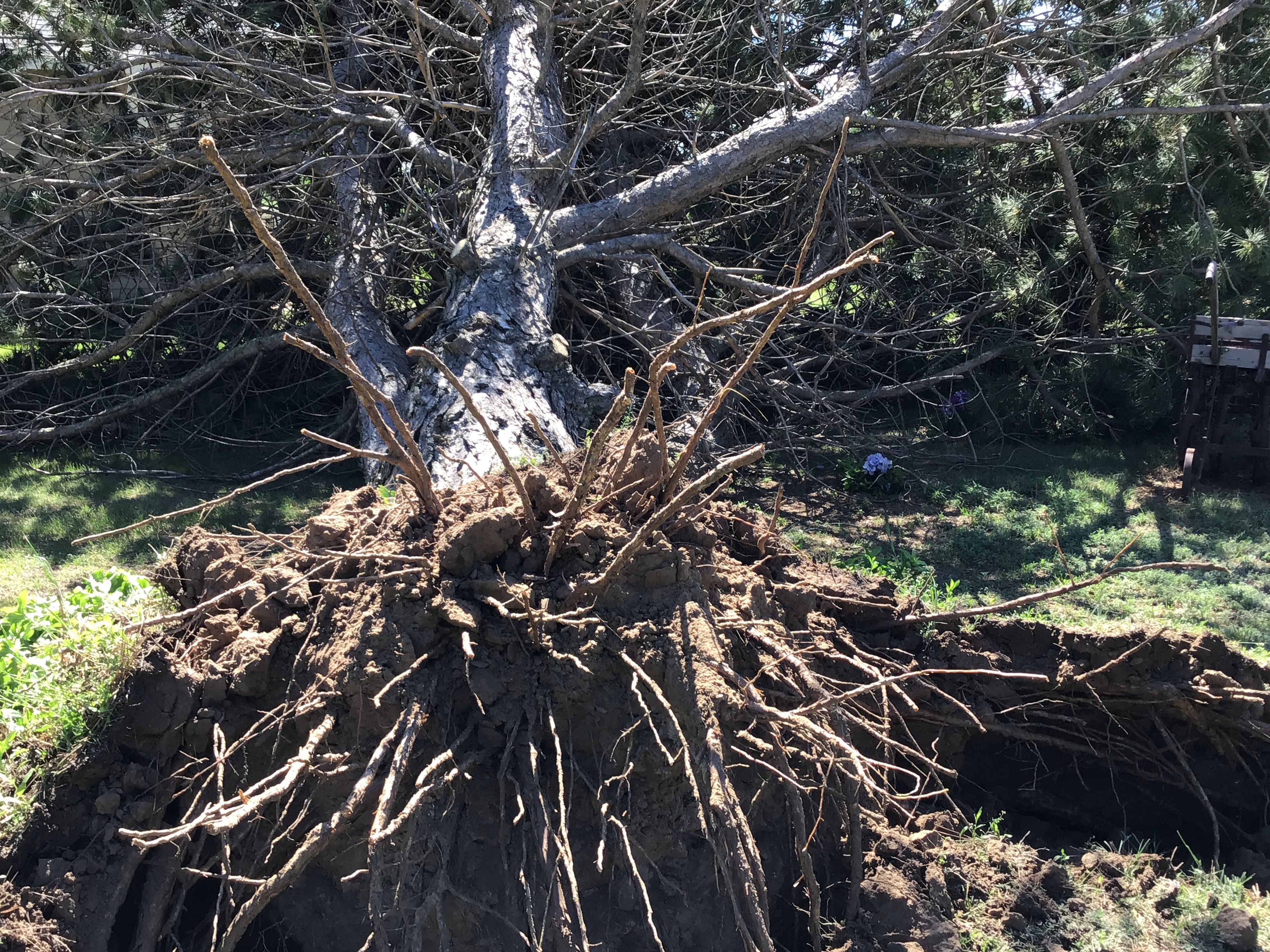
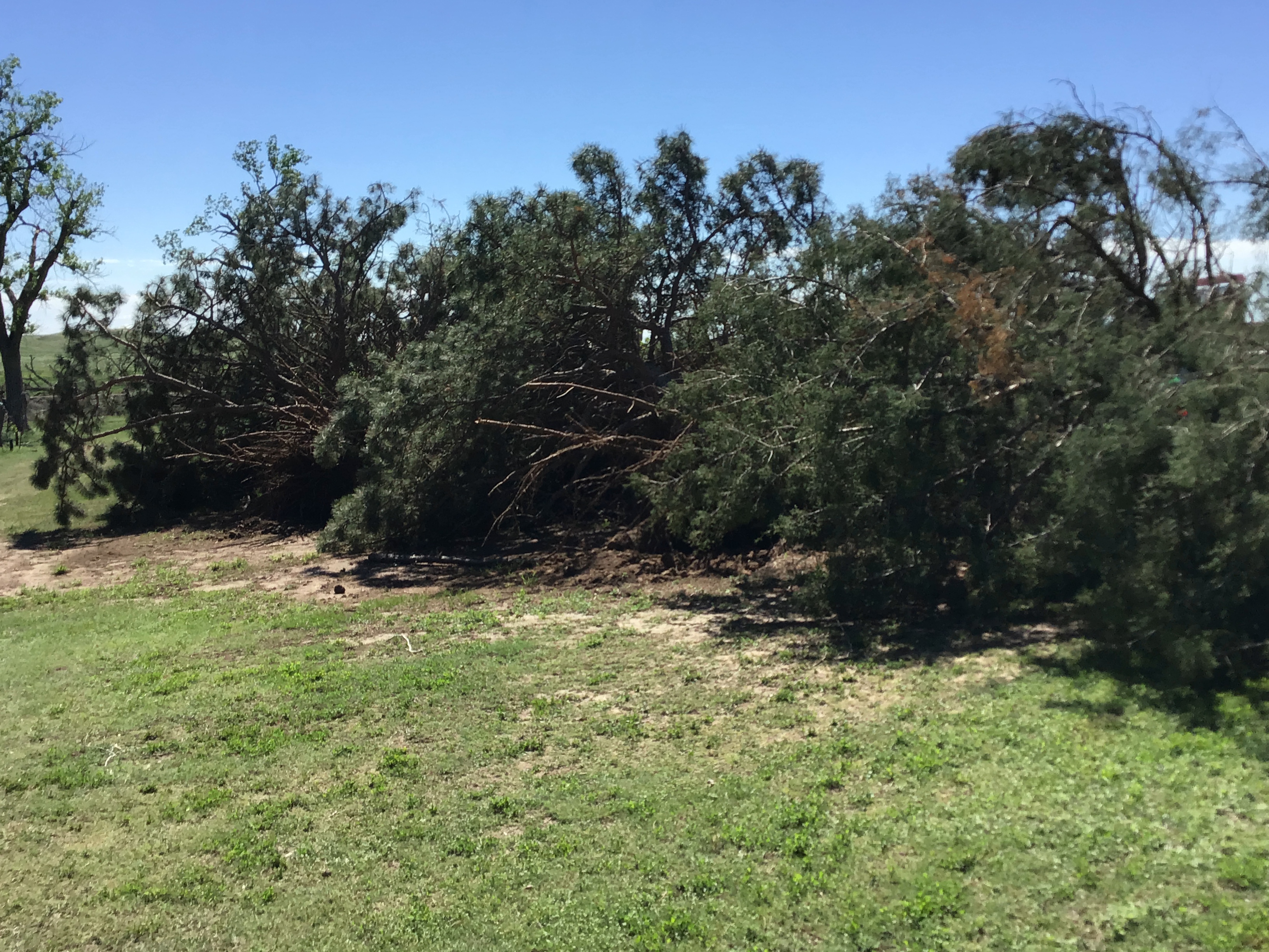
AN EF-2 TORNADO OCCURRED SHORTLY AFTER THE
BRIEF EF-0 NORTH OF BENKELMAN. DAMAGE
CONSISTED OF MANY BROKEN POWER POLES, A
LARGE GROVE OF ELM TREES THAT WERE
DEMOLISHED, ADDITIONAL TREES THAT WERE
SNAPPED OR UPROOTED, DAMAGE TO A RESIDENCE
INCLUDING LOSS OF SHINGLES, LOSS OF METAL
ROOFING PANELS TO A FARM OUTBUILDING, A
TRACTOR WAS MOVED 100 YARDS, AND DAMAGE TO
ANTIQUE VEHICLES DUE TO FALLING TREE DEBRIS.
THE TORNADO MOVED ALONG HIGHWAY 61 FOR MOST
OF ITS LIFE, SNAPPING MORE POWER POLES AND
TWISTING SIGNS. THE TORNADO SEEMED TO STRAY
SLIGHTLY WEST OF THE HIGHWAY AND CONTINUED
ACCORDING TO SPOTTER AND CHASER REPORTS. THE
TORNADO EVENTUALLY ENDED OVER OPEN FIELDS.
0344 PM HAIL 8 N LEOTI 38.60N 101.34W
05/26/2021 U0.75 INCH WICHITA KS PUBLIC
REPORT FROM MPING: DIME (0.75 IN.). DELAYED
REPORT.
0346 PM HAIL 5 N BENKELMAN 40.12N 101.53W
05/26/2021 M1.25 INCH DUNDY NE PUBLIC
DELAYED REPORT BY TRAINED SPOTTER.
0349 PM HAIL 8 N LEOTI 38.60N 101.34W
05/26/2021 U1.25 INCH WICHITA KS PUBLIC
REPORT FROM MPING: HALF DOLLAR (1.25 IN.).
0351 PM TORNADO 12 NW MAX 40.24N 101.55W
05/26/2021 DUNDY NE TRAINED SPOTTER
TRAINED SPOTTER LOCATED TO THE EAST OF THE
STORM IN NORTHWEST HITCHCOCK COUNTY REPORTED
THEY CAN SEE THE TORNADO IN DUNDY COUNTY. IT
WAS REPORTED AS A STOVE PIPE TORNADO.
0352 PM HAIL 8 N LEOTI 38.60N 101.36W
05/26/2021 E1.00 INCH WICHITA KS STORM CHASER
REPORT RECEIVED OF QUARTER SIZED HAIL NORTH
OF LEOTI.
0355 PM TORNADO 12 NW MAX 40.24N 101.53W
05/26/2021 DUNDY NE TRAINED SPOTTER
TORNADO STILL ON THE GROUND, STARTING TO
ROPE OUT. GOLF BALL SIZE HAIL REPORTED AS
WELL.
0403 PM TORNADO 8 N MAX 40.23N 101.40W
05/26/2021 DUNDY NE LAW ENFORCEMENT
NEW TORNADO ON GROUND WITH EAST CIRCULATION
AT MM16 ON HWY 61.
0411 PM TORNADO 4 NNE MAX 40.16N 101.38W
05/26/2021 DUNDY NE PUBLIC
PUBLIC REPORTED TORNADO.
0419 PM HAIL 13 NW STRATTON 40.29N 101.38W
05/26/2021 E1.75 INCH DUNDY NE STORM CHASER
0419 PM TORNADO 1 WNW HERNDON 39.92N 100.81W
05/26/2021 RAWLINS KS NWS EMPLOYEE
OFF DUTY NWS EMPLOYEE REPORTS TORNADO NEAR
HERNDON. WAS LOOKING WEST IN BETWEEN OBERLIN
AND MCCOOK.
0420 PM TORNADO 5 WNW LUDELL 39.89N 101.04W
05/26/2021 RAWLINS KS TRAINED SPOTTER
SPOTTER REPORTED POSSIBLE TORNADO ROUGHLY 5
MILES NORTH OF ATWOOD.
0423 PM TORNADO 11 WSW PALISADE 40.30N 101.30W
05/26/2021 HITCHCOCK NE TRAINED SPOTTER
SPOTTER WAS LOCATED IN EXTREME SOUTHERN
CHASE COUNTY LOOKING SOUTH.
0425 PM HAIL 12 N MAX 40.29N 101.38W
05/26/2021 E2.50 INCH DUNDY NE PUBLIC
0429 PM TORNADO 7 WNW HERNDON 39.96N 100.90W
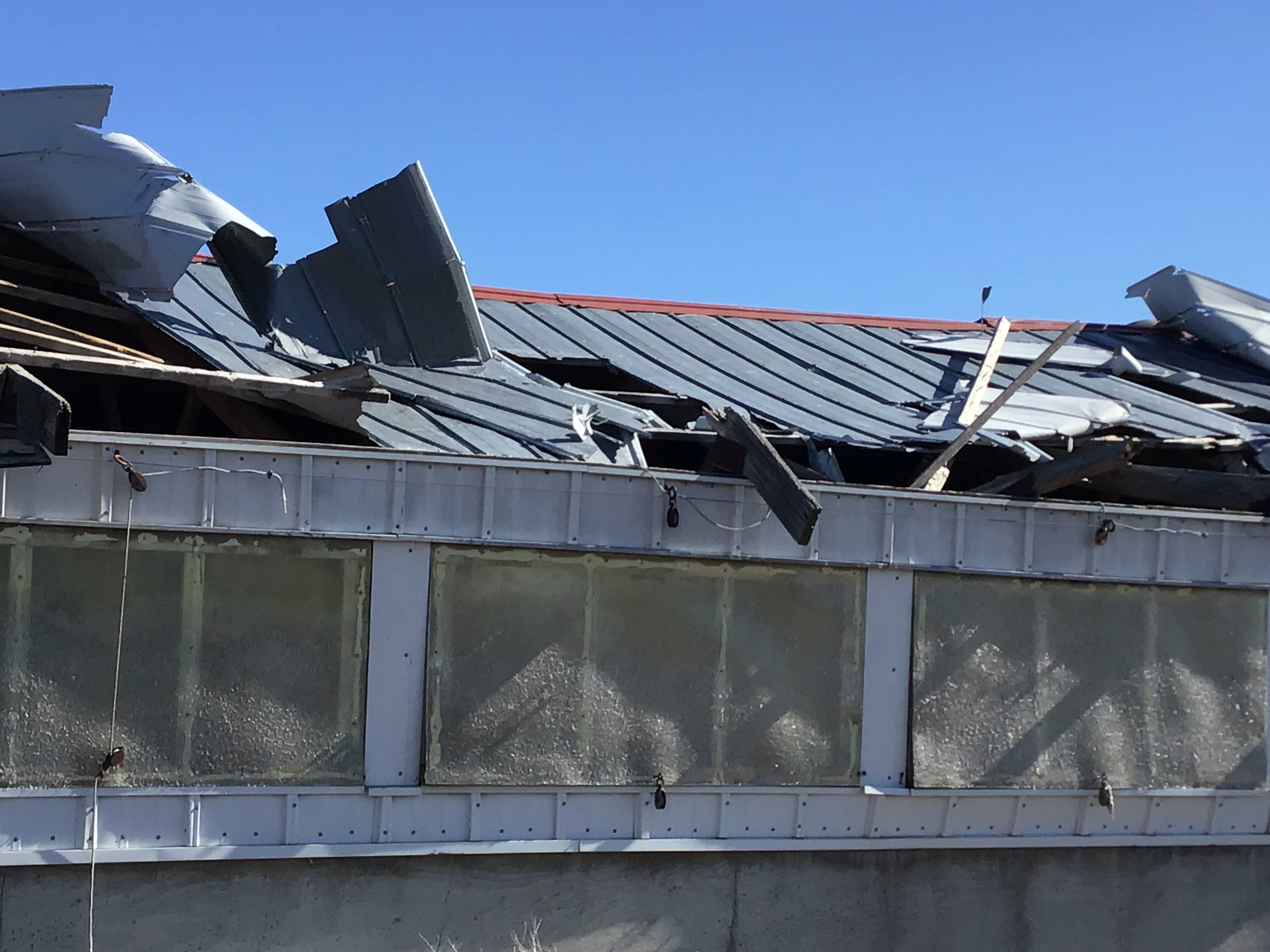
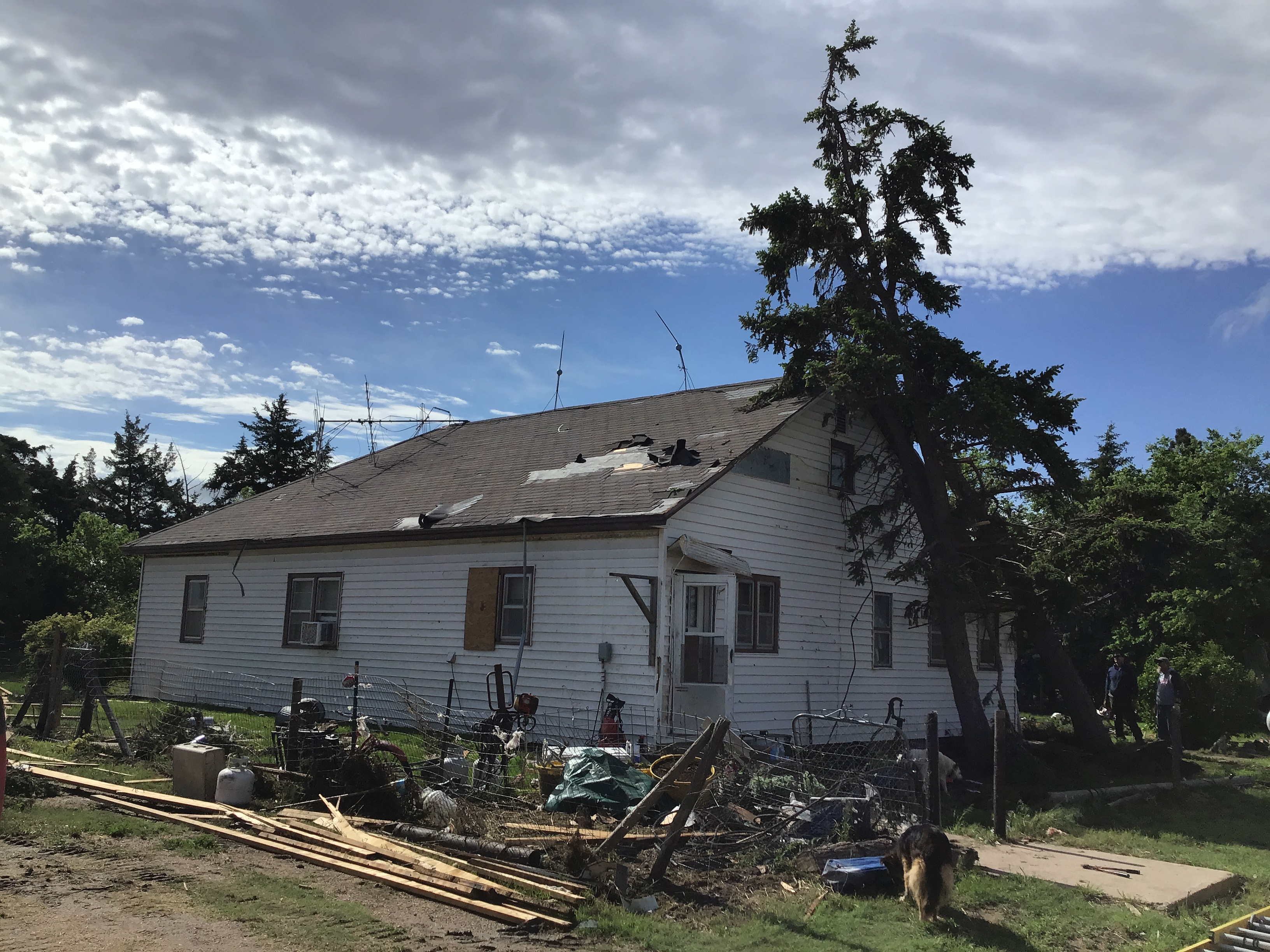
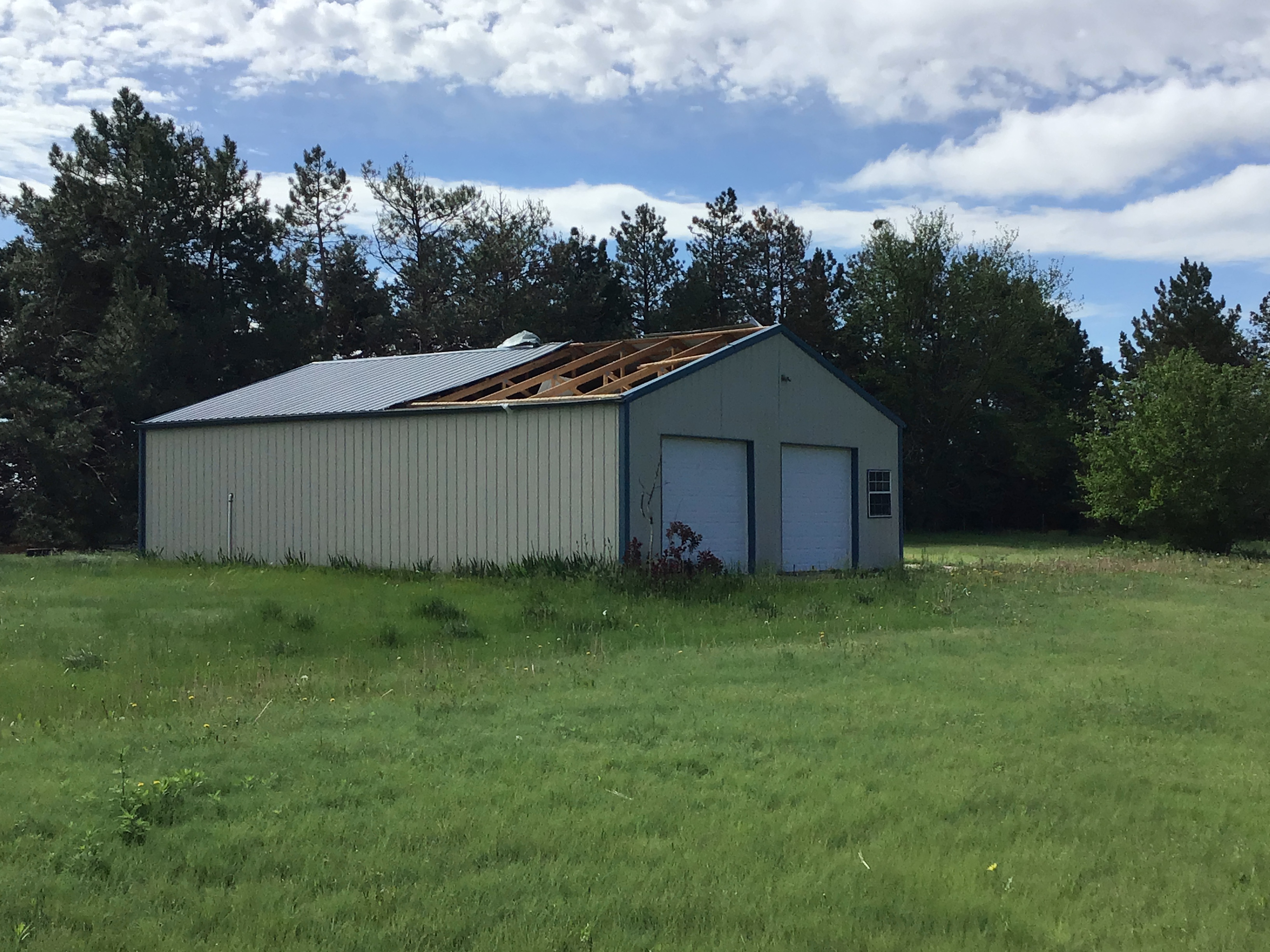
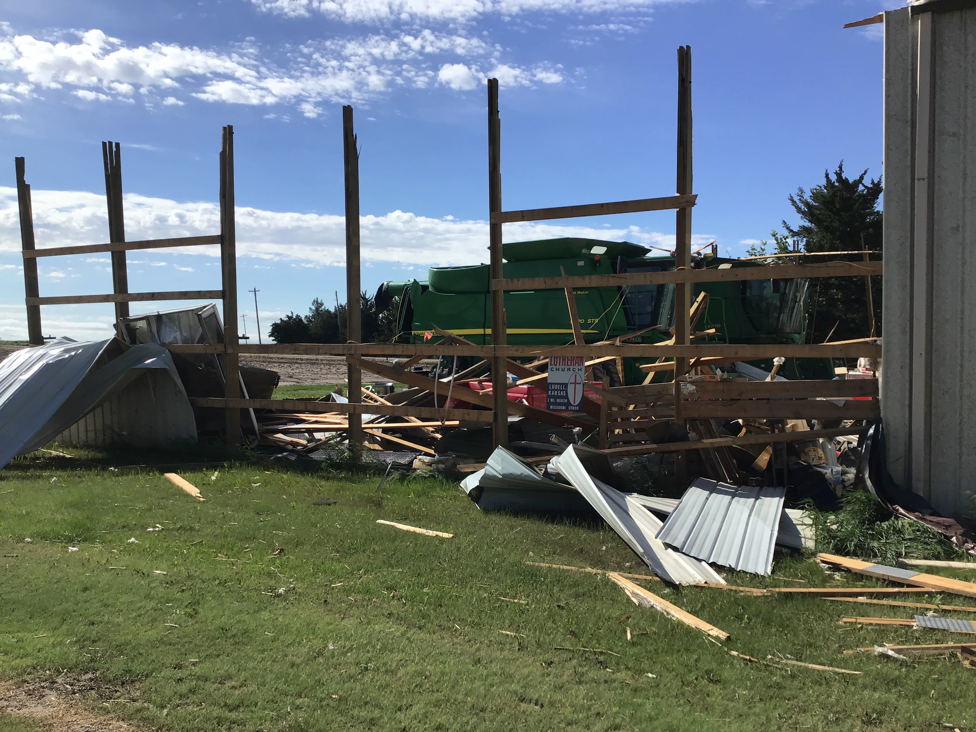
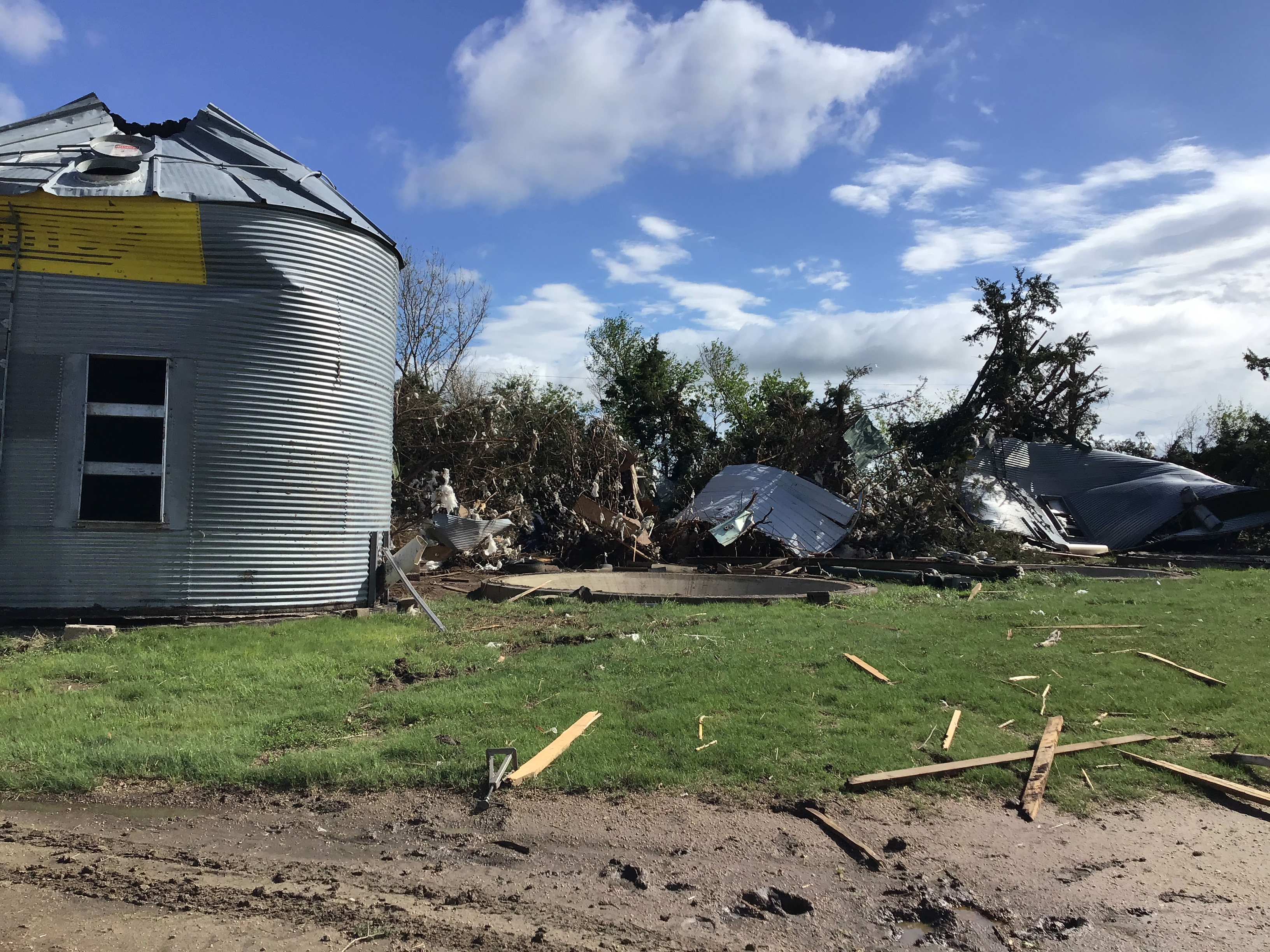
05/26/2021 RAWLINS KS NWS STORM SURVEY
A TORNADO HIT A FARMSTEAD NORTHWEST OF
HERNDON. AT THE FARMSTEAD, DAMAGE CONSISTED
OF NUMEROUS SNAPPED AND UPROOTED TREES,
SEVERAL FARM STRUCTURES DAMAGED INCLUDING
TORN OFF METAL ROOFING, BROKEN WINDOWS, AND
EVEN A FEW METAL SUPPORT BEAMS BENT IN.
SEVERAL GRAIN SILOS WERE DAMAGED OR REMOVED
FROM THEIR FOUNDATION. WINDOWS WERE BROKEN
IN VEHICLES. A HOUSE SUFFERED DAMAGE TO
SHINGLES, A FEW BROKEN WINDOWS, AND A TREE
FALLING ONTO IT. THE TORNADO THEN PROCEEDED
NORTH ON COUNTY ROAD 27, SNAPPING POWER
LINES AND DAMAGING A REFURBISHED FARMSTEAD
SCHOOLHOUSE. AS THE TORNADO MOVED NORTH, IT
ALSO DAMAGED SOME OIL STORAGE TANKS,
SPREADING THE OIL TO THE NORTHEAST IN A
FIELD AS IT TURNED. THE TORNADO CROSSED THE
FIELD, AND A DAMAGE PATH WAS OBSERVED ON
COUNTY ROAD 29. FROM THERE, THERE WAS NO
OBSERVABLE DAMAGE SO IT WAS DETERMINED THE
TORNADO ENDED AT THIS LOCATION.
0430 PM TORNADO 7 NW HERNDON 39.97N 100.88W
05/26/2021 RAWLINS KS LAW ENFORCEMENT
CORRECTS PREVIOUS TORNADO REPORT FROM 7 NW
HERNDON. TORNADO REPORTED AT CR Y AND CR 30.
FIRST RESPONDERS REPORT HOMESTEAD STRUCK IN
THE AREA.
0431 PM HAIL 3 ESE WINONA 39.05N 101.18W
05/26/2021 M1.00 INCH LOGAN KS TRAINED SPOTTER
0433 PM HAIL WINONA 39.06N 101.24W
05/26/2021 M1.00 INCH LOGAN KS TRAINED SPOTTER
0438 PM TORNADO 7 NW HERNDON 39.97N 100.89W
05/26/2021 RAWLINS KS PUBLIC
TORNADO WAS ON THE GROUND AT TIME OF CALL.
0440 PM TORNADO 8 NW HERNDON 39.99N 100.90W
05/26/2021 RAWLINS KS LAW ENFORCEMENT
ANOTHER TORNADO REPORTED JUST WEST OF THE
FIRST ONE. NEW TORNADO LOCATED ROUGHLY AT CR
32 AND CR Y OR Z.
0447 PM TORNADO 11 S CULBERTSON 40.07N 100.83W
05/26/2021 HITCHCOCK NE NWS EMPLOYEE
OFF-DUTY NWS EMPLOYEE REPORTS A TORNADO THAT
LASTED ABOUT 5 MIN WHILE LOOKING W/NW OF
DANBURY.
0447 PM TORNADO 4 NE HERNDON 39.96N 100.74W
05/26/2021 DECATUR KS TRAINED SPOTTER
0449 PM HAIL 6 N HERNDON 40.00N 100.79W
05/26/2021 E1.75 INCH RAWLINS KS TRAINED SPOTTER
0450 PM TORNADO 10 NNW LUDELL 39.99N 101.02W
05/26/2021 RAWLINS KS PUBLIC
POSSIBLE TORNADO REPORTED AT CR DD AND CR
22.
0500 PM HAIL 10 S MCCOOK 40.06N 100.62W
05/26/2021 E1.75 INCH RED WILLOW NE PUBLIC
HAIL ATLEAST THIS SIZE.
0508 PM HAIL 6 WSW MINGO 39.23N 101.06W
05/26/2021 M1.00 INCH THOMAS KS PUBLIC
REPORT FROM MPING: QUARTER SIZED HAIL
REPORTED.
0512 PM HAIL 5 N TRAER 40.00N 100.66W
05/26/2021 E1.75 INCH DECATUR KS TRAINED SPOTTER
HAIL RANGED FROM PENNY TO QUARTER WITH
OCCASIONAL GOLF BALL.
0526 PM HAIL 15 SSW MCCOOK 40.01N 100.77W
05/26/2021 E0.70 INCH HITCHCOCK NE PUBLIC
REPORTED PEA TO DIME SIZE HAIL ALONG WITH A
FEW FUNNEL CLOUDS.
0528 PM FUNNEL CLOUD 2 SW TRAER 39.91N 100.68W
05/26/2021 DECATUR KS TRAINED SPOTTER
REPORTED FUNNEL CLOUD TO THE NORTHWEST.
0534 PM HAIL 4 WSW DANBURY 40.02N 100.48W
05/26/2021 E0.75 INCH RED WILLOW NE TRAINED SPOTTER
PENNY TO DIME SIZE HAIL REPORTED.
0542 PM TORNADO 6 ENE CEDAR BLUFFS 40.00N 100.46W
05/26/2021 UF1 DECATUR KS TRAINED SPOTTER
SPOTTER REPORT OF BRIEF TORNADO TOUCHING
DOWN. FUNNEL CLOUDS REMAIN SEEN IN THE AREA
WITH RAPID ROTATION.
0607 PM HAIL 3 S MCCOOK 40.16N 100.63W
05/26/2021 E0.75 INCH RED WILLOW NE PUBLIC
REPORT OF PEA TO PENNY SIZE HAIL.
0611 PM HAIL HOXIE 39.36N 100.44W
05/26/2021 M1.00 INCH SHERIDAN KS PUBLIC
PUBLIC REPORT OF QUARTER SIZE HAIL.
0621 PM HAIL 14 S ATWOOD 39.61N 101.02W
05/26/2021 E1.00 INCH RAWLINS KS PUBLIC
REPORT RECEIVED VIA SOCIAL MEDIA.
0630 PM HAIL HOXIE 39.36N 100.44W
05/26/2021 E1.75 INCH SHERIDAN KS PUBLIC
DELAYED REPORT VIA SOCIAL MEDIA OF HAIL UP
TO GOLF BALL SIZE AND A STORM RAIN TOTAL OF
0.16 INCH.
0631 PM HAIL 8 SSE ATWOOD 39.70N 100.98W
05/26/2021 M1.25 INCH RAWLINS KS PUBLIC
REPORT VIA TWITTER.
0643 PM HAIL 10 WSW PALISADE 40.31N 101.29W
05/26/2021 M0.25 INCH HITCHCOCK NE TRAINED SPOTTER
0652 PM HAIL 4 W NEW ALMELO 39.59N 100.20W
05/26/2021 E1.00 INCH DECATUR KS TRAINED SPOTTER
0653 PM HAIL 5 W NEW ALMELO 39.58N 100.22W
05/26/2021 M1.50 INCH DECATUR KS TRAINED SPOTTER
0657 PM HAIL 6 S HERNDON 39.83N 100.77W
05/26/2021 M2.00 INCH RAWLINS KS STORM CHASER
DELAYED REPORT. RELAYED VIA SOCIAL MEDIA.
HAIL MEASURE 2.25 INCHES.
0657 PM HAIL 7 SSW HERNDON 39.81N 100.83W
05/26/2021 E2.00 INCH RAWLINS KS TRAINED SPOTTER
0658 PM HAIL 6 SSW HERNDON 39.83N 100.83W
05/26/2021 E1.75 INCH RAWLINS KS TRAINED SPOTTER
0700 PM HAIL 6 S HERNDON 39.82N 100.80W
05/26/2021 E1.75 INCH RAWLINS KS PUBLIC
0704 PM HAIL 8 S HERNDON 39.79N 100.77W
05/26/2021 M1.75 INCH RAWLINS KS PUBLIC
0705 PM HAIL 4 SE HERNDON 39.86N 100.73W
05/26/2021 E1.75 INCH DECATUR KS TRAINED SPOTTER
0706 PM HAIL 6 S HERNDON 39.83N 100.78W
05/26/2021 E1.50 INCH RAWLINS KS TRAINED SPOTTER
0718 PM HAIL 4 N NEW ALMELO 39.64N 100.11W
05/26/2021 E0.88 INCH NORTON KS PUBLIC
0720 PM HAIL 2 SW TRAER 39.91N 100.68W
05/26/2021 M1.00 INCH DECATUR KS TRAINED SPOTTER
BIGGEST HAIL STONE JUST OVER 1 INCH IN
DIAMETER.
0722 PM HAIL 7 SE PALISADE 40.28N 101.02W
05/26/2021 E1.00 INCH HITCHCOCK NE PUBLIC
OCCURRED WITH ESTIMATED WIND GUSTS OF
ATLEAST 60 MPH.
0722 PM TSTM WND GST 7 SE PALISADE 40.28N 101.02W
05/26/2021 E60 MPH HITCHCOCK NE PUBLIC
ESTIMATED WINDS TO BE ATLEAST 60 MPH. THIS
OCCURRED WITH QUARTER SIZE HAIL.
0723 PM HAIL 5 SE PALISADE 40.30N 101.03W
05/26/2021 E2.75 INCH HITCHCOCK NE PUBLIC
GOLF BALL TO BASEBALL SIZE HAIL REPORTED.
0736 PM HAIL NORTON 39.84N 99.89W
05/26/2021 M1.75 INCH NORTON KS PUBLIC
DELAYED REPORT VIA FACEBOOK.
0736 PM HAIL 4 W NORTON 39.83N 99.96W
05/26/2021 E1.50 INCH NORTON KS STORM CHASER
0739 PM TSTM WND GST 3 W CULBERTSON 40.22N 100.89W
05/26/2021 M53 MPH HITCHCOCK NE MESONET
0740 PM HAIL NORTON 39.84N 99.89W
05/26/2021 E1.00 INCH NORTON KS PUBLIC
0743 PM HAIL 3 W NORTON 39.83N 99.94W
05/26/2021 M1.50 INCH NORTON KS TRAINED SPOTTER
MAINLY NICKEL TO QUARTER HAIL, A FEW PING
PONG BALL HAIL STONES MIXED.
0749 PM HAIL 7 SSW NORTON 39.75N 99.96W
05/26/2021 E1.75 INCH NORTON KS PUBLIC
HAIL RANGED FROM 1.5-1.75 INCHES.
0800 PM TSTM WND DMG 10 S HILL CITY 39.22N 99.86W
05/26/2021 GRAHAM KS PUBLIC
A QUARTER TO HALF THE SHINGLES ON A ROOF
PEELED OFF BY THE WIND. ESTIMATED TIME OF
REPORT FROM RADAR.
0805 PM HAIL 1 W MCCOOK 40.21N 100.65W
05/26/2021 U0.75 INCH RED WILLOW NE PUBLIC
REPORT FROM MPING: DIME (0.75 IN.).
0807 PM TORNADO 8 S HILL CITY 39.24N 99.85W
05/26/2021 GRAHAM KS STORM CHASER
BRIEF TORNADO WITH SMALL GROUND CIRCULATIONS
REPORTED AT THIS LOCATION.
0810 PM NON-TSTM WND GST 7 S HILL CITY 39.27N 99.85W
05/26/2021 M60 MPH GRAHAM KS PUBLIC
REPORT OF 60MPH WIND GUST FROM THE SOUTH.
0823 PM HAIL 1 W MCCOOK 40.21N 100.65W
05/26/2021 E0.75 INCH RED WILLOW NE PUBLIC
REPORT FROM MPING: DIME (0.75 IN.).
0830 PM TSTM WND DMG 1 WNW MCCOOK 40.21N 100.64W
05/26/2021 RED WILLOW NE PUBLIC
REPORT FROM MPING: 1-INCH TREE LIMBS BROKEN;
SHINGLES BLOWN OFF.
0831 PM FLASH FLOOD 1 WNW MCCOOK 40.21N 100.64W
05/26/2021 RED WILLOW NE PUBLIC
REPORT FROM MPING: RIVER/CREEK OVERFLOWING;
CROPLAND/YARD/BASEMENT FLOODING.
0833 PM TSTM WND GST 2 E MCCOOK 40.20N 100.58W
05/26/2021 M51 MPH RED WILLOW NE ASOS
ASOS STATION KMCK MCCOOK AIRPORT.
0844 PM HAIL HILL CITY 39.37N 99.84W
05/26/2021 E1.00 INCH GRAHAM KS STORM CHASER
0900 PM FLASH FLOOD BOGUE 39.36N 99.69W
05/26/2021 GRAHAM KS TRAINED SPOTTER
SPOTTER REPORTS THAT RAIN IS STARTING TO
POOL AND FLOW LIKE A RIVER NEAR LOCATION.
0900 PM HAIL BOGUE 39.36N 99.69W
05/26/2021 M1.00 INCH GRAHAM KS TRAINED SPOTTER
0927 PM FUNNEL CLOUD 6 W TRENTON 40.18N 101.12W
05/26/2021 HITCHCOCK NE STORM CHASER
POSSIBLE FUNNEL CLOUDS SIGHTED IN AREA.
 |
Media use of NWS Web News Stories is encouraged! Please acknowledge the NWS as the source of any news information accessed from this site. |
|