Severe thunderstorms and heavy rain are expected across the central High Plains into parts of the central and southern Plains and in the the Mid-Atlantic today. Intense, dangerous heat will persist across the West, Southwest, and Southern Plains into the end of the week. Elevated to critical fire weather conditions expected in the Great Basin and Four Corners region. Read More >
Overview
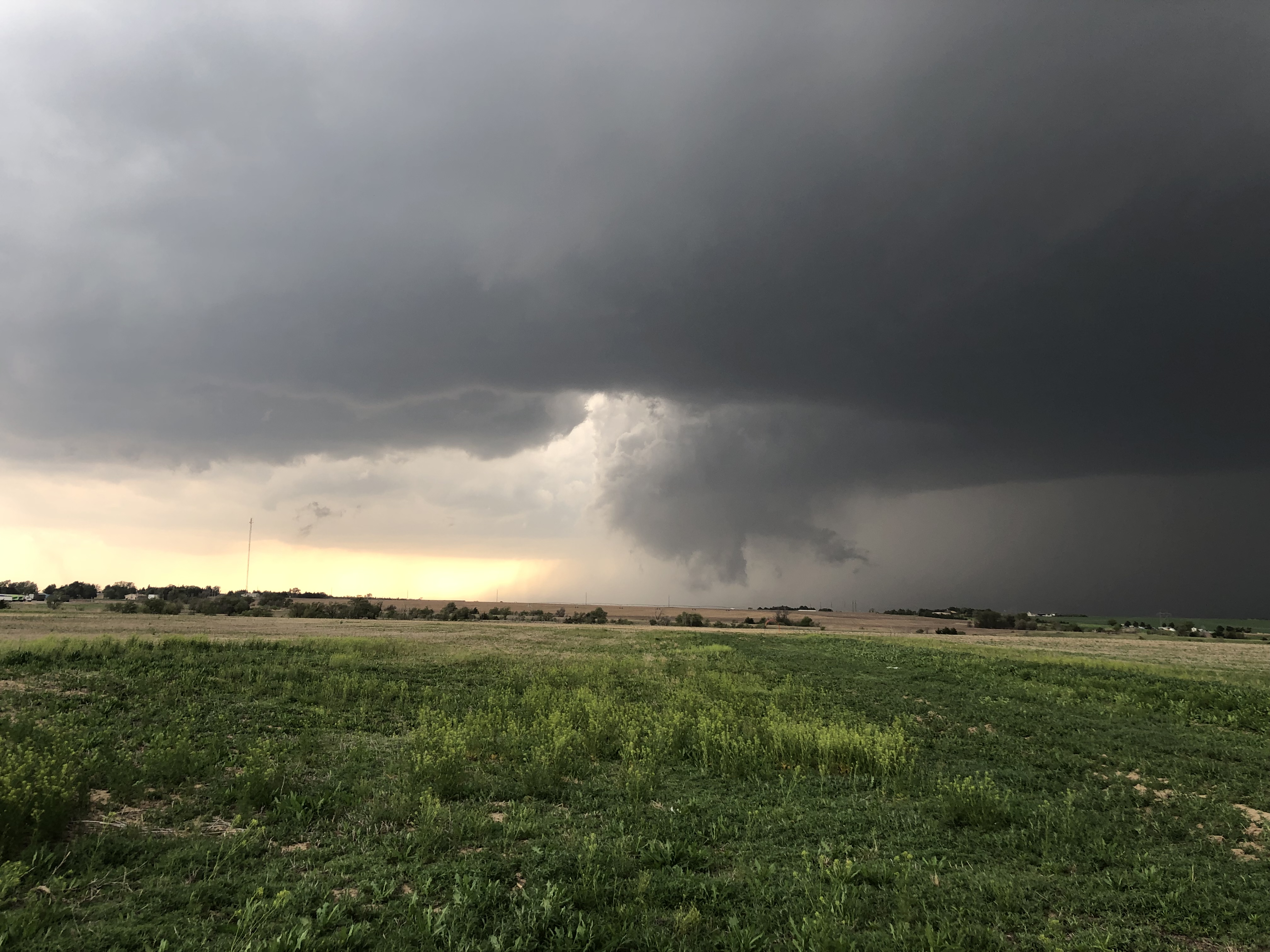
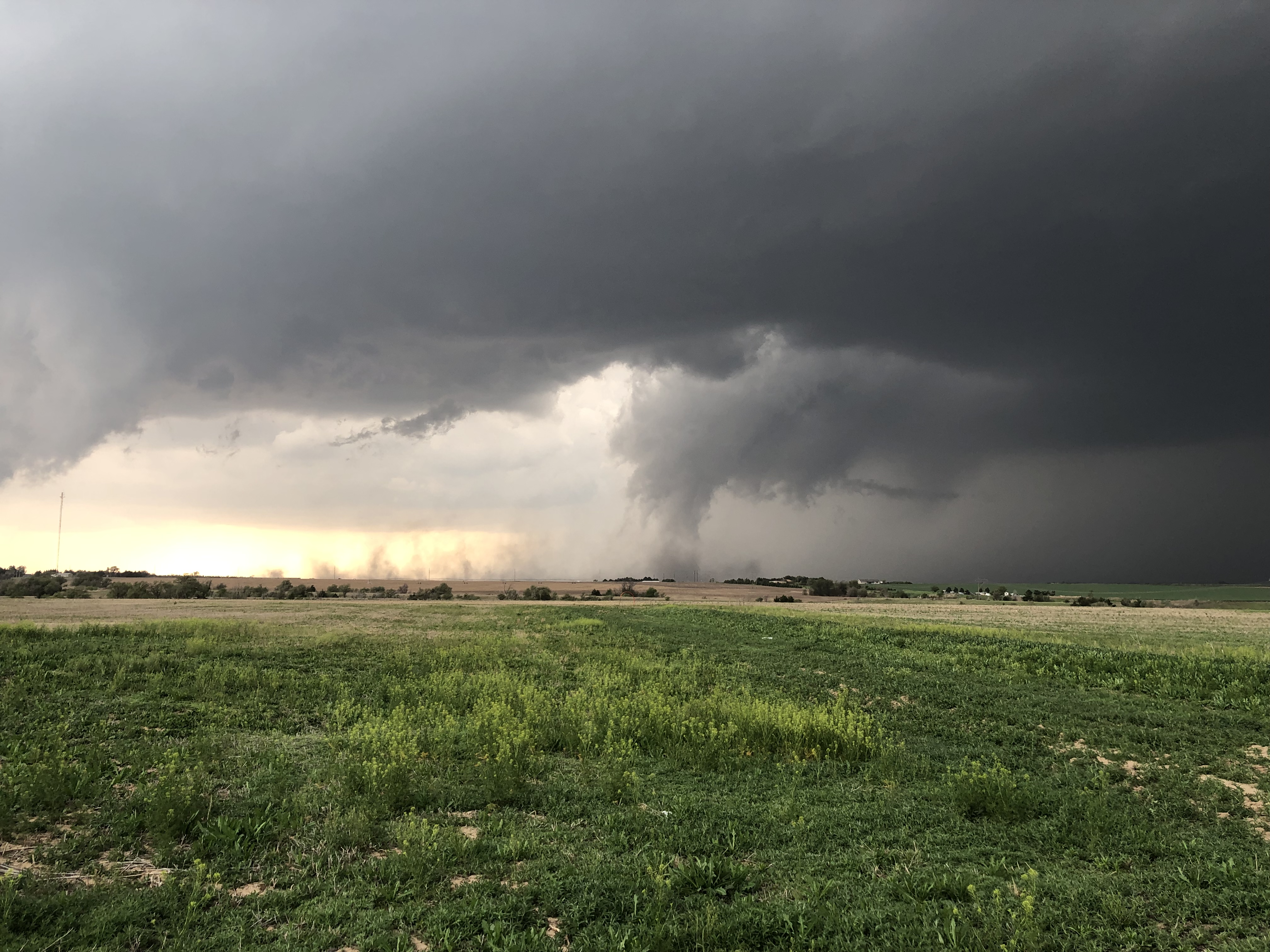
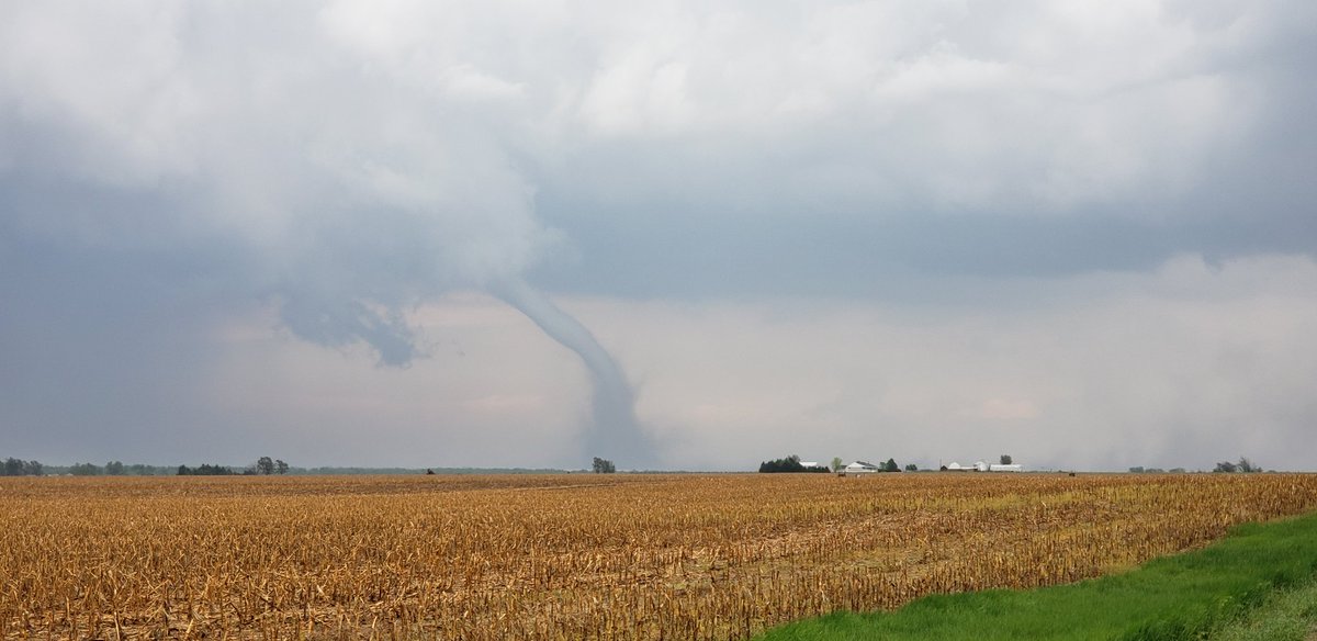
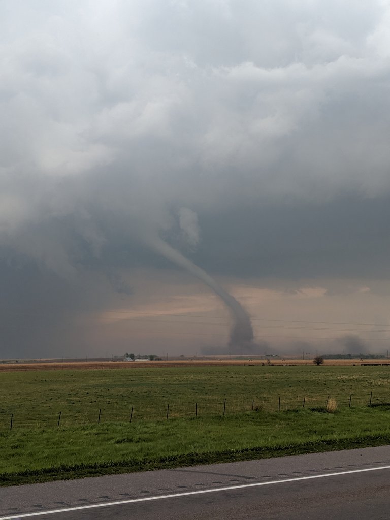
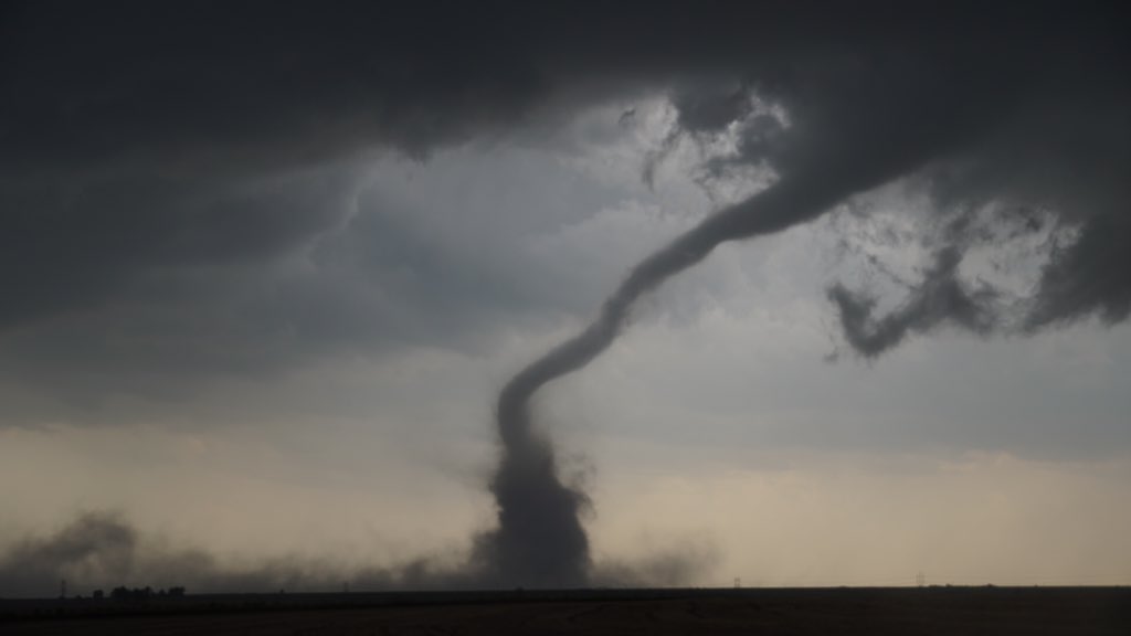
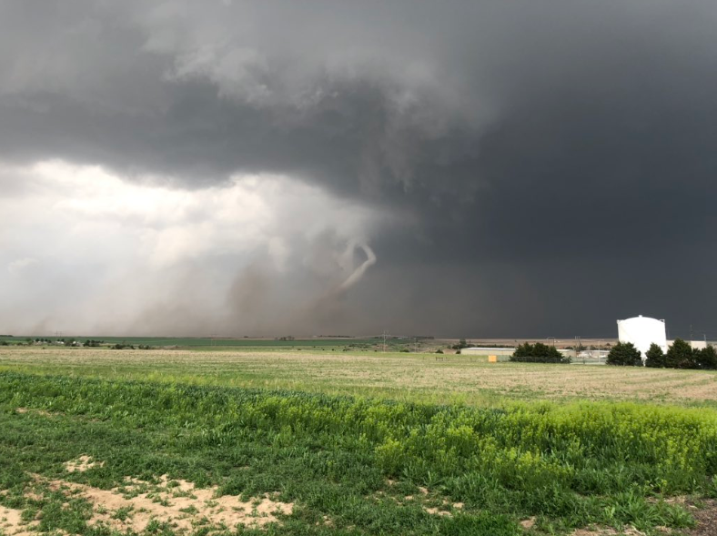
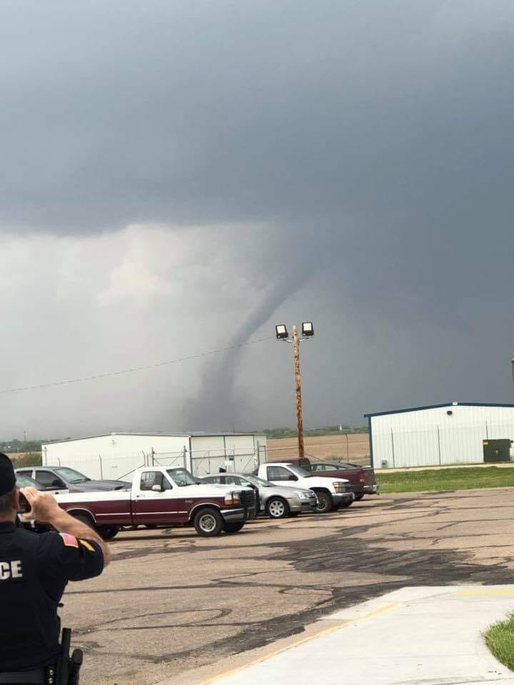
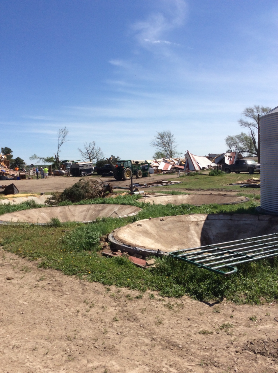
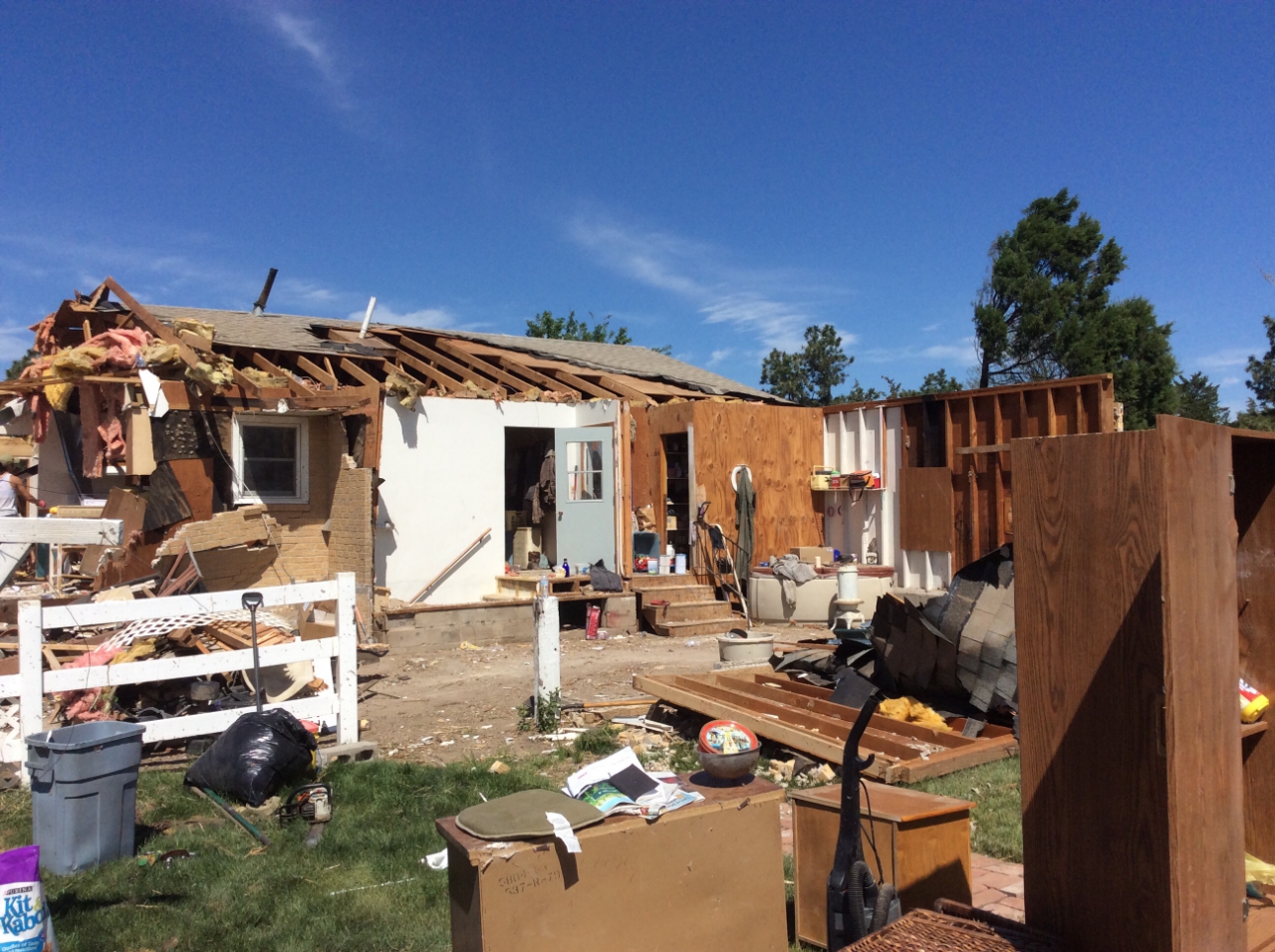
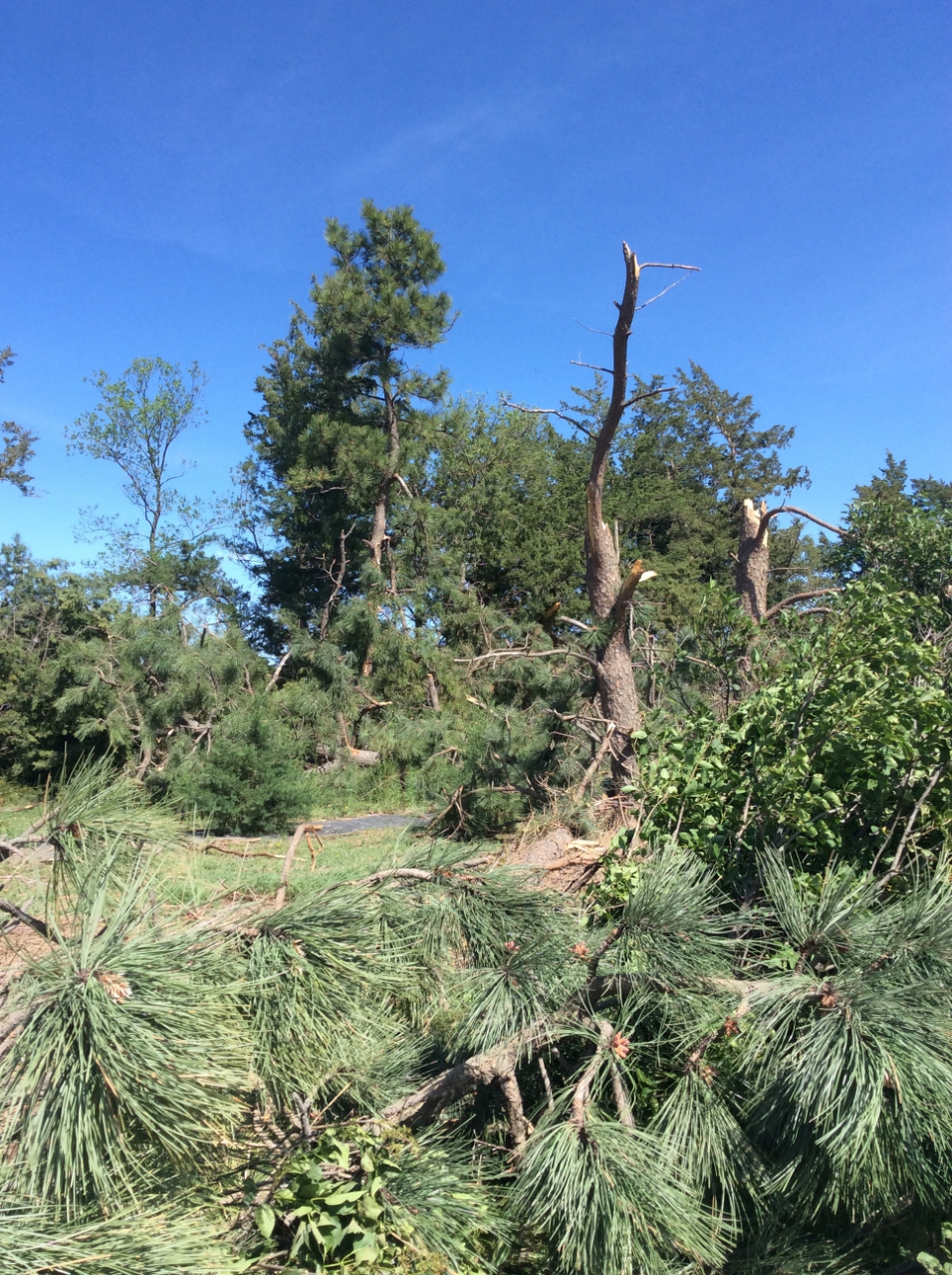
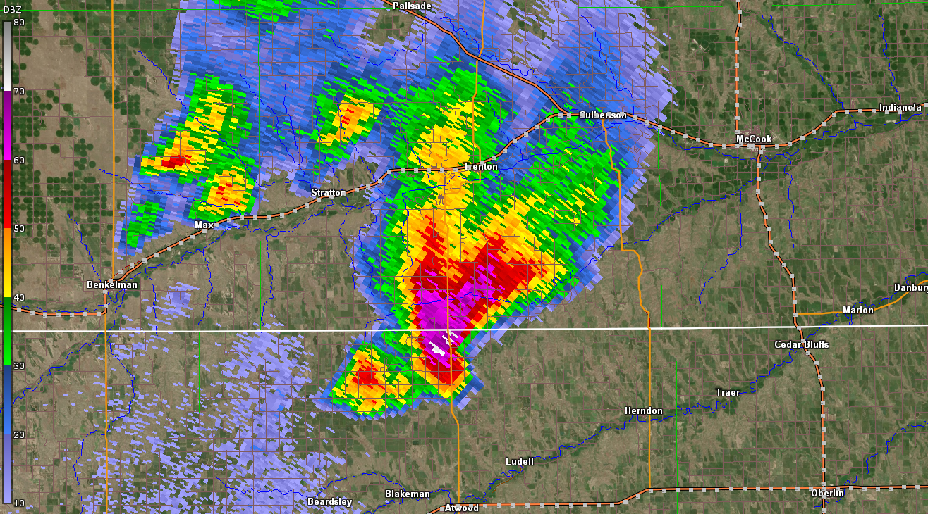
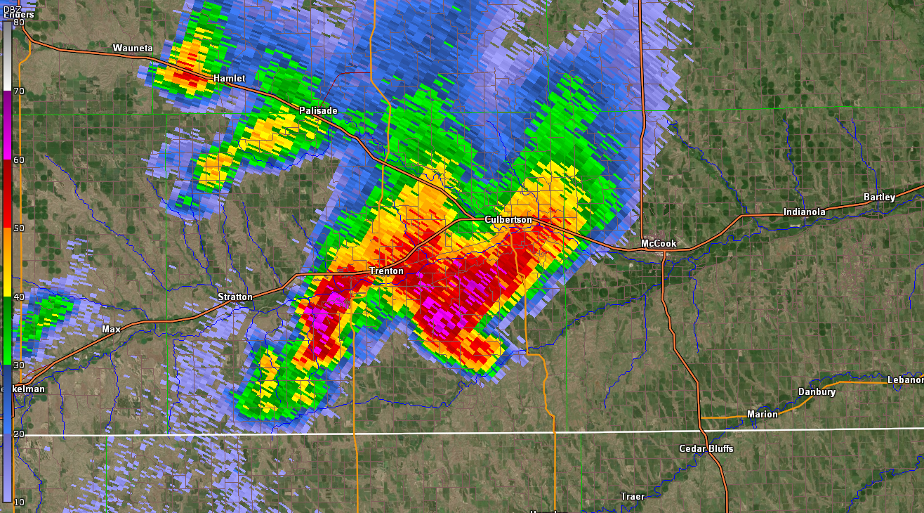
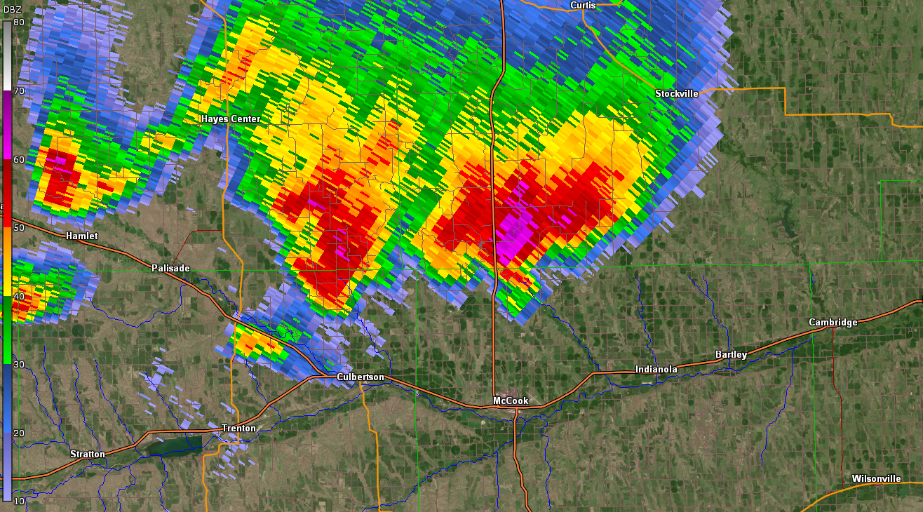
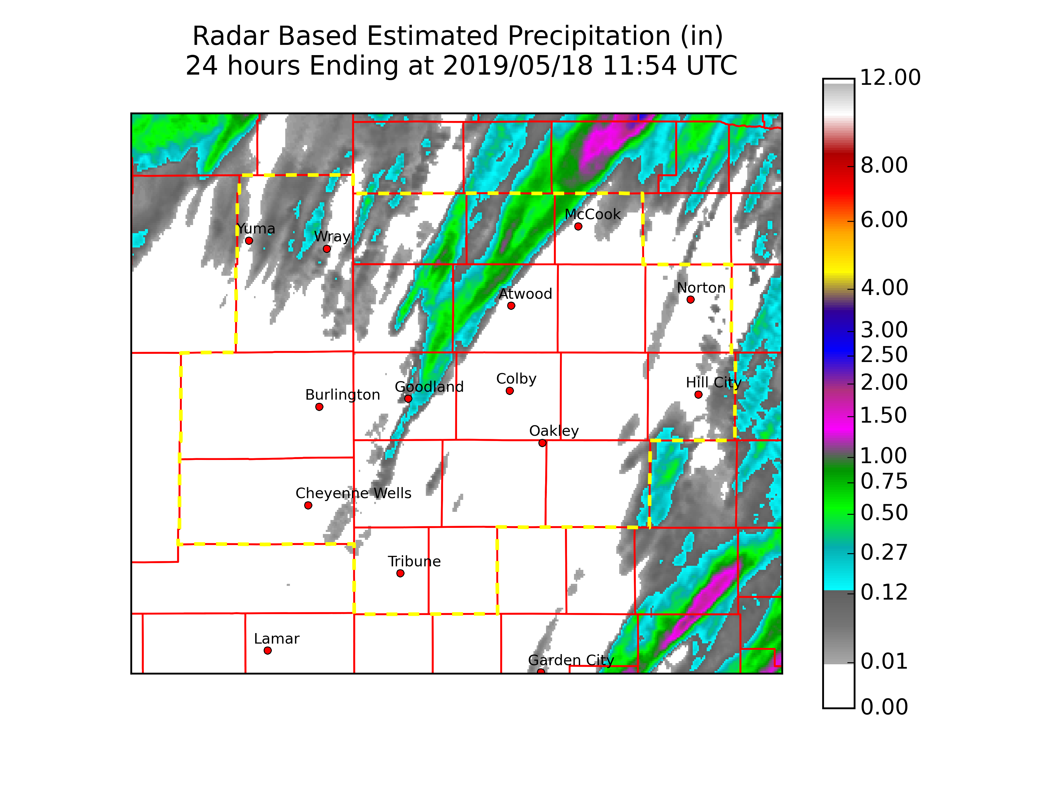
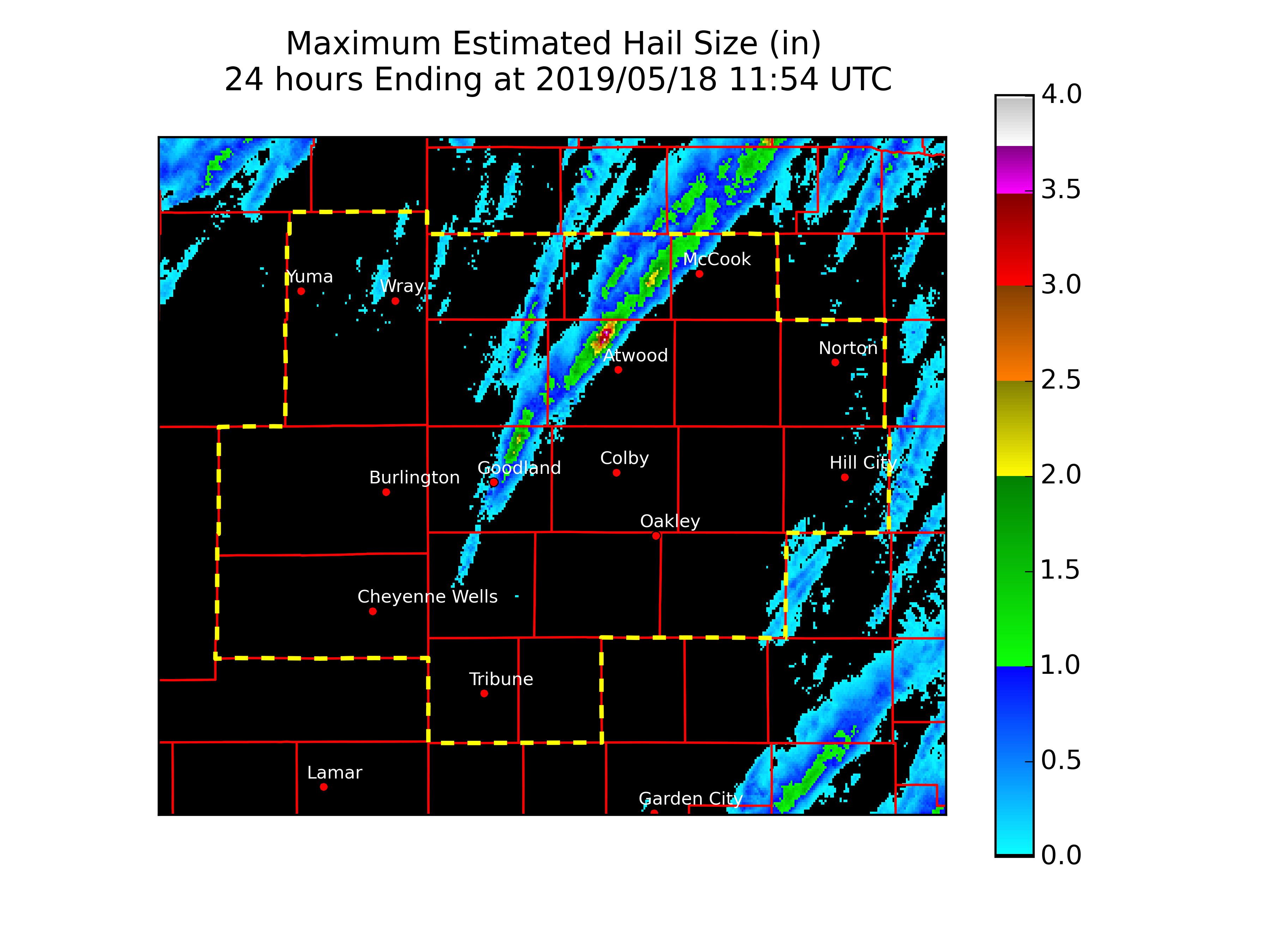
A significant outbreak of severe weather occurred across the NWS Goodland service area on May 17th, 2019. A supercell thunderstorm developed just south of Goodland, Kansas and then moved northeast across the region. The storm then proceeded into the areas served by NWS North Platte, NE and NWS Hastings, NE. Throughout it's lifetime in the NWS Goodland service area, the storm produced hail up to 2-3 inches in diameter and at least 4 tornadoes. 3 of the tornadoes remained over open pasture, producing little to no damage. The most significant tornado occurred in Red Willow County in SW Nebraska.
Tornadoes:
|
|
||||||||||
|
||||||||||
|
Tornado - 11 SSE Stratton, NE
Track Map 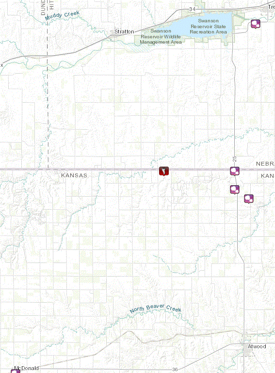  |
||||||||||||||||
|
Tornado - 8 S Culbertson, NE
Track Map 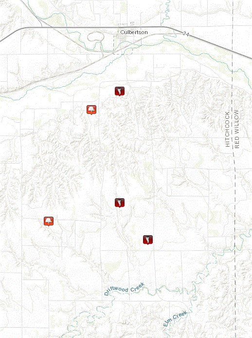 |
||||||||||||||||
|
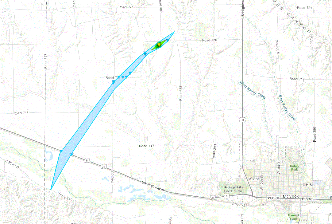
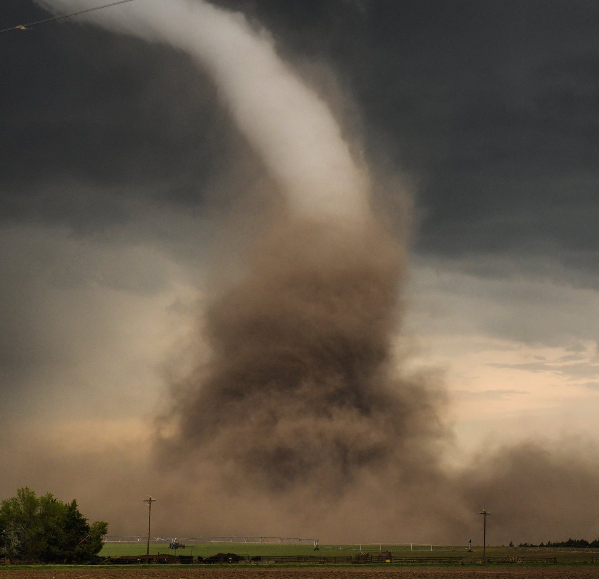
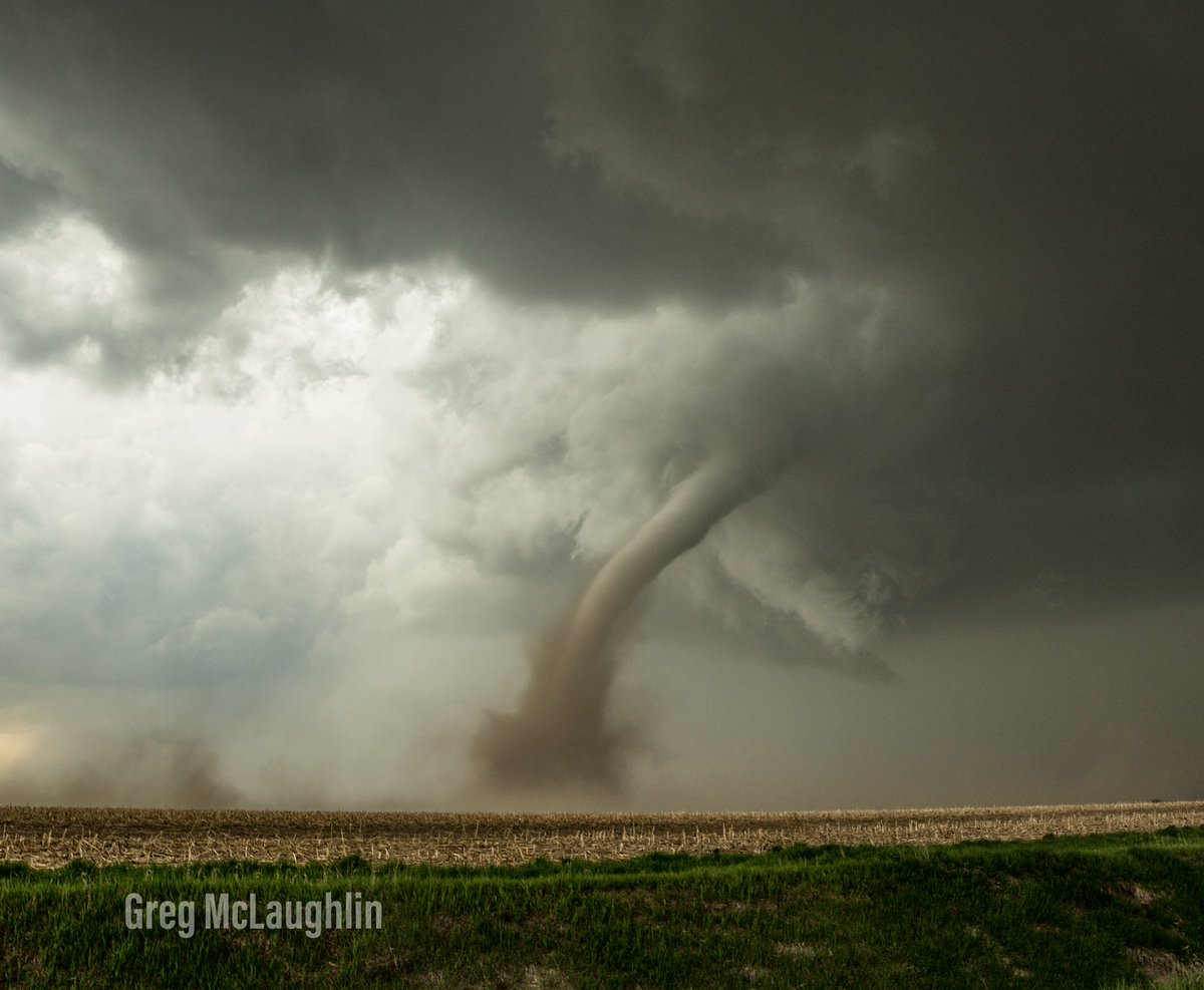
Tornado - NW of McCook, NE
|
||||||||||||||||
|
Tornado - 10 N McCook, NE
Track Map 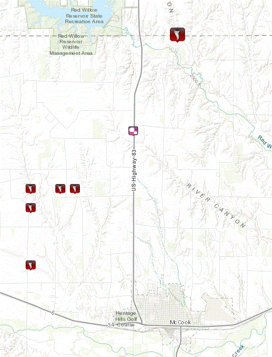 |
||||||||||||||||
The Enhanced Fujita (EF) Scale classifies tornadoes into the following categories:
| EF0 Weak 65-85 mph |
EF1 Moderate 86-110 mph |
EF2 Significant 111-135 mph |
EF3 Severe 136-165 mph |
EF4 Extreme 166-200 mph |
EF5 Catastrophic 200+ mph |
 |
|||||
Photos & Video
Header
 |
 |
 |
 |
| Just before McCook tornado formation (Bryan Wood) |
McCook tornado formation (Bryan Wood) |
McCook tornado (Greg Johnson) |
McCook tornado (Greg McLaughlin) |
 |
 |
 |
 |
| McCook tornado (Jeff Frame) |
McCook tornado (Brittany Newman) |
McCook tornado (Freddy McKinney) |
McCook tornado dissapating (Bryan Wood) |
 |
 |
 |
 |
| McCook tornado from airport (Karen Storrs) |
Northern Rawlins County (Jared Ireland) |
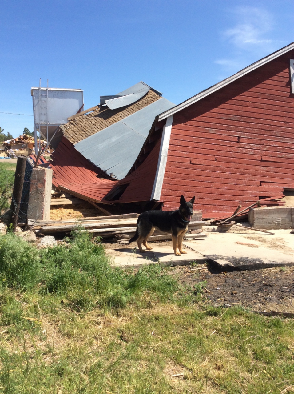
Damage NW of McCook (NWS Storm Survey) |
Damage NW of McCook (NWS Storm Survey) |
 |
 |
 |
 |
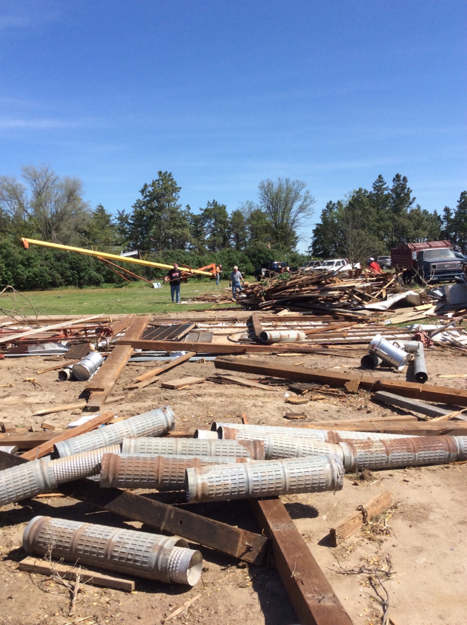
| Damage NW of McCook (NWS Storm Survey) |
Damage NW of McCook (NWS Storm Survey) |
Damage NW of McCook (NWS Storm Survey) |
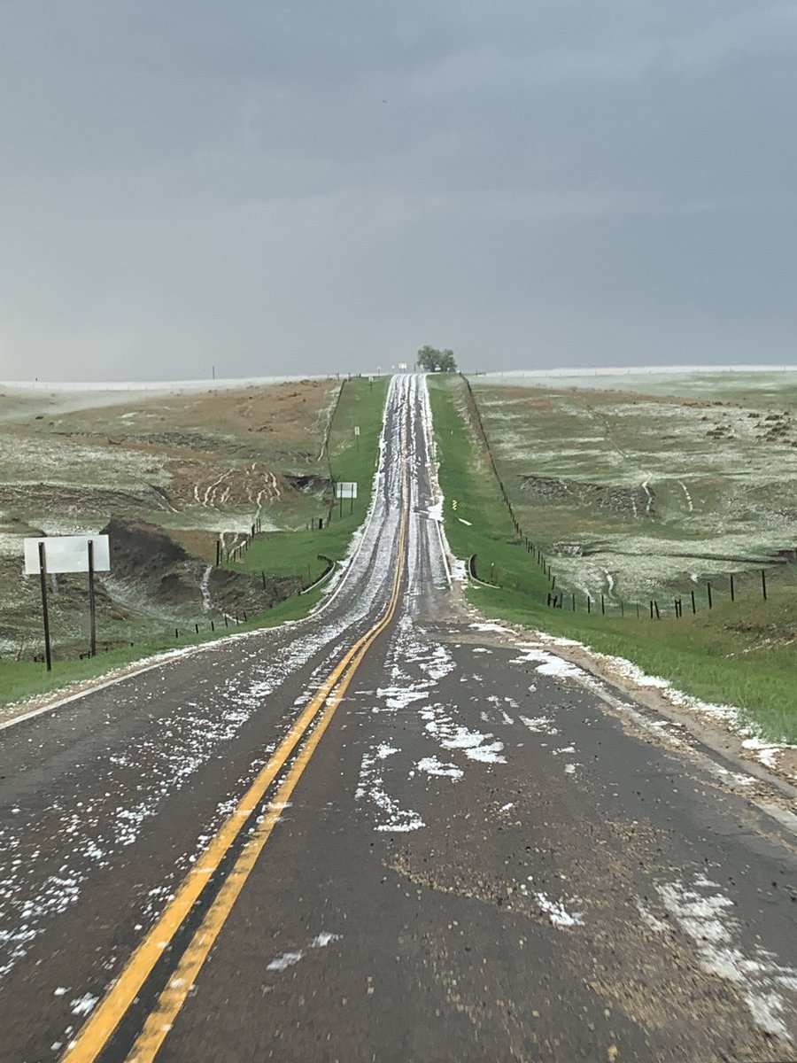
Hail on Road (DDubs) |
 |
 |
 |
 |
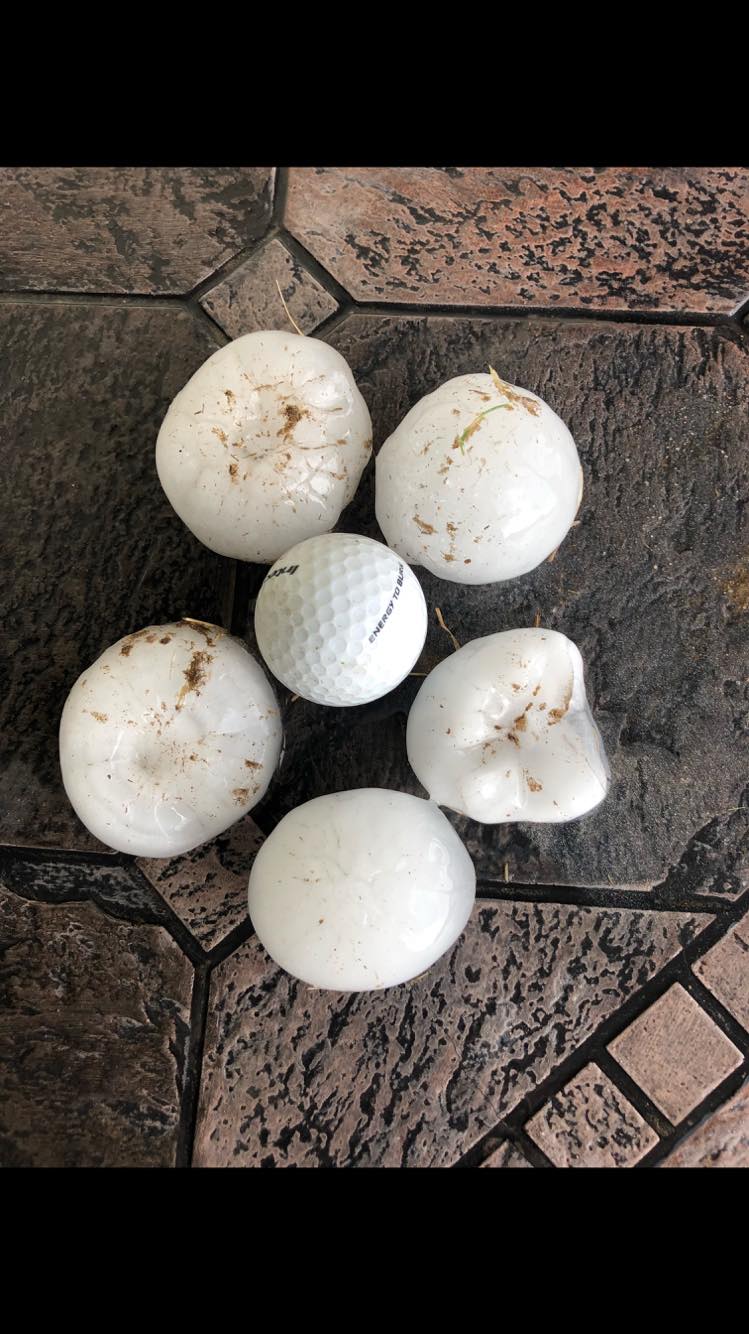
| Hail north of Edson, KS (Elizabeth Lundquist) |
Hail 1 mile SE of Benkelman (Julie Jones) |
Hail around Edson, KS (Sharmis Blake) |
Near HWY 25 and KS/NE State Line (Ellie Palmer) |
Radar
Header
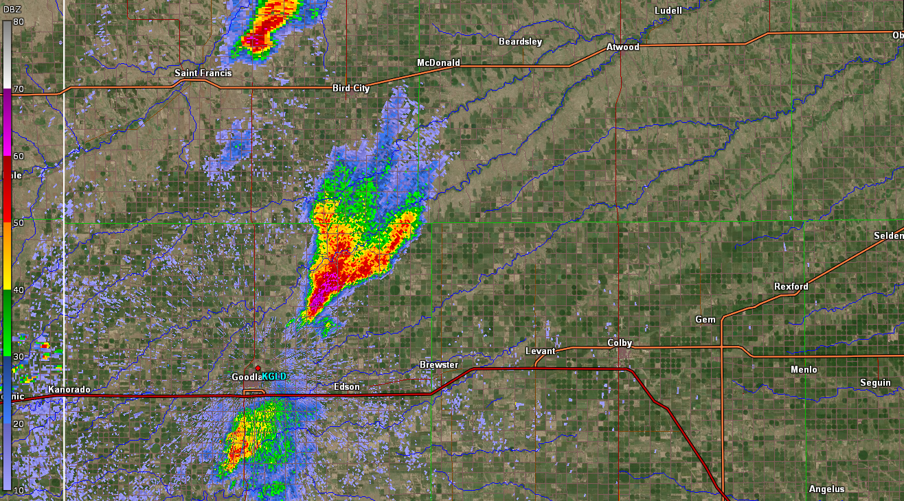 |
 |
 |
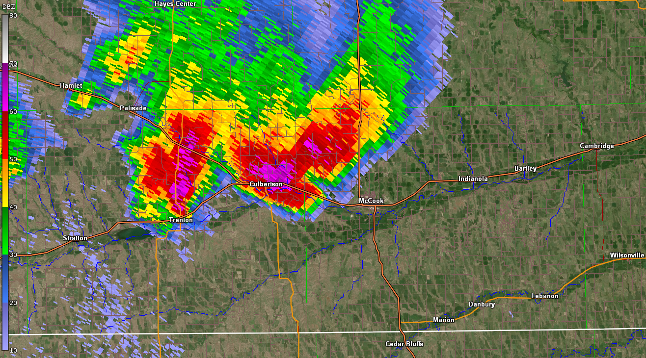 |
| Storm shortly after developing, producing up to 2" hail (4:54 pm CDT) | Storm crossing into Nebraska, produced 3" hail at this time (5:15 pm CDT) | Storm south of Culbertson, first reports of funnel clouds and/or tornadoes received at this time (5:36 pm CDT) | Storm when tornado formed along HWY 34 west of McCook, NE. |
 |
 |
 |
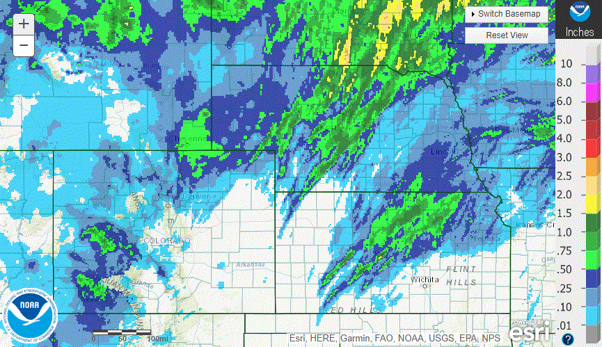 |
| Tornadic thunderstorm moving into Frontier County Nebraska (served by NWS North Platte, NE) | NWS Goodland Forecast Area Rainfall | NWS Goodland Forecast Area Radar Estimated Hail Tracks | Regional Radar. Note the swaths of rain associated with supercells over SW Kansas and NW Kansas to central Nebraska |
Storm Reports
712
NWUS53 KGLD 180235
LSRGLD
PRELIMINARY LOCAL STORM REPORT...SUMMARY
NATIONAL WEATHER SERVICE GOODLAND KS
835 PM MDT FRI MAY 17 2019
..TIME... ...EVENT... ...CITY LOCATION... ...LAT.LON...
..DATE... ....MAG.... ..COUNTY LOCATION..ST.. ...SOURCE....
..REMARKS..
0502 PM TORNADO 6 NW MCCOOK 40.27N 100.69W
05/17/2019 RED WILLOW NE TRAINED SPOTTER
TORNADO ON THE GROUND NORTHWEST OF MCCOOK.
0501 PM TORNADO 7 ENE CULBERTSON 40.27N 100.72W
05/17/2019 RED WILLOW NE STORM CHASER
CORRECTS PREVIOUS REPORT STATING MULTIPLE
REPORTS FROM STORM CHASERS VIA TWITTER WITH
PICTURE OF A TORNADO ROUGHLY 2 MILES SOUTH
OF CULBERTSON, NE LOOKING WEST FROM HWY 17.
LOCATION OF TORNADO HAS BEEN ADJUSTED TO
REFLECT RADAR.
0500 PM TORNADO 6 WNW MCCOOK 40.23N 100.72W
05/17/2019 RED WILLOW NE NWS EMPLOYEE
NWS EMPLOYEE REPORTED VIA TWITTER A TORNADO
APPROXIMATELY 6 MILES EAST OF CULBERTSON,
NE. IT WAS A WEAK ROPE TORNADO THAT DID NOT
LAST LONG. REPORT INCLUDED SEVERAL PICTURES
CONFIRMING THE TORNADO.
0500 PM HAIL 7 NNW MCCOOK 40.30N 100.65W
05/17/2019 M1.50 INCH RED WILLOW NE TRAINED SPOTTER
TRAINED SPOTTER REPORTED HAIL UP TO 1 TO 1.5
INCHES IN DIAMETER ALONG US HWY 83 NORTH OF
MCCOOK, NE. TIME ESTIMATED VIA RADAR.
0500 PM TORNADO 8 N INDIANOLA 40.35N 100.42W
05/17/2019 RED WILLOW NE PUBLIC
PUBLIC REPORTED VIA FACEBOOK WITH A PICTURE
A TORNADO APPROXIMATELY 8 MILES NORTH OF
INDIANOLA, NE LOOKING WEST.
0500 PM TORNADO 10 N MCCOOK 40.35N 100.62W
05/17/2019 RED WILLOW NE PUBLIC
PUBLIC REPORTED VIA FACEBOOK WITH A PICTURE
A TORNADO ABOUT 10 MILES N OF MCCOOK, NE.
0500 PM TORNADO 6 NW MCCOOK 40.27N 100.70W
05/17/2019 RED WILLOW NE NWS EMPLOYEE
OFF DUTY NWS EMPLOYEE CONFIRMS TORNADO ON
THE GROUND NORTHWEST OF MCCOOK.
0455 PM TORNADO 6 ENE CULBERTSON 40.26N 100.72W
05/17/2019 RED WILLOW NE STORM CHASER
STORM CHASER REPORTED PIVOTS KNOCKED OVER,
TREE DAMAGE, POWER LINES DOWN, AND MINOR
DAMAGE TO FARM.
0459 PM HAIL 8 NNE TRENTON 40.28N 100.97W
05/17/2019 M1.00 INCH HITCHCOCK NE PUBLIC
PEA TO QUARTER SIZE HAIL REPORTED FROM STORM
CHASERS.
0445 PM HAIL 1 NNE CULBERTSON 40.24N 100.83W
05/17/2019 M2.00 INCH HITCHCOCK NE CO-OP OBSERVER
NUMEROUS HAIL FROM 1.5 TO 2 INCHES IN
DIAMETER. OCCURRED FROM 430-500 PM MOUNTAIN
TIME.
0444 PM TORNADO 6 S CULBERTSON 40.14N 100.84W
05/17/2019 HITCHCOCK NE LAW ENFORCEMENT
MCCOOK PD REPORTED A TORNADO ABOUT 7 MILES
WSW OF MCCOOK.
0440 PM HAIL 12 SSE TRENTON 40.01N 100.95W
05/17/2019 M0.88 INCH HITCHCOCK NE FIRE DEPT/RESCUE
FIRE DEPT REPORTED HAIL UP TO NICKEL SIZE
HAIL 1.5 MILES NORTH OF THE KS/NE STATE LINE
ON RD 368.
0440 PM TORNADO 8 S CULBERTSON 40.12N 100.82W
05/17/2019 HITCHCOCK NE EMERGENCY MNGR
EMERGENCY MANAGEMENT REPORTED A POSSIBLE
TORNADO 8 MILES S OF CULBERTSON ON HWY 17
BETWEEN MILE MARKERS 10 AND 11.
0438 PM FUNNEL CLOUD 7 ESE TRENTON 40.13N 100.89W
05/17/2019 HITCHCOCK NE STORM CHASER
PERSISTENT FUNNEL CLOUD NEAR TRENTON.
0436 PM FUNNEL CLOUD 3 SSW CULBERTSON 40.19N 100.86W
05/17/2019 HITCHCOCK NE TRAINED SPOTTER
3 FUNNEL CLOUDS REPORTED BY TRAINED SPOTTER
3 MILES SSW.
0434 PM HAIL 1 SW TRENTON 40.16N 101.03W
05/17/2019 E0.25 INCH HITCHCOCK NE FIRE DEPT/RESCUE
FIRE CHIEF IN TRENTON, NE REPORTED HAIL UP
TO 3/8IN IN DIAMTER 1 MILE SW OF TRENTON AT
534 CDT.
0428 PM TORNADO 11 SSE STRATTON 40.00N 101.16W
05/17/2019 HITCHCOCK NE FIRE DEPT/RESCUE
FIRE DEPT/TRAINED SPOTTERS REPORTED A BRIEF
TORNADO TOUCHED DOWN NEAR THE KS/NE STATE
LINE ABOUT 7 TO 8 MILES EAST OF HWY 25. THE
TORNADO WAS IN OPEN COUNTRY WITH NO
STRUCTURES NEAR BY.
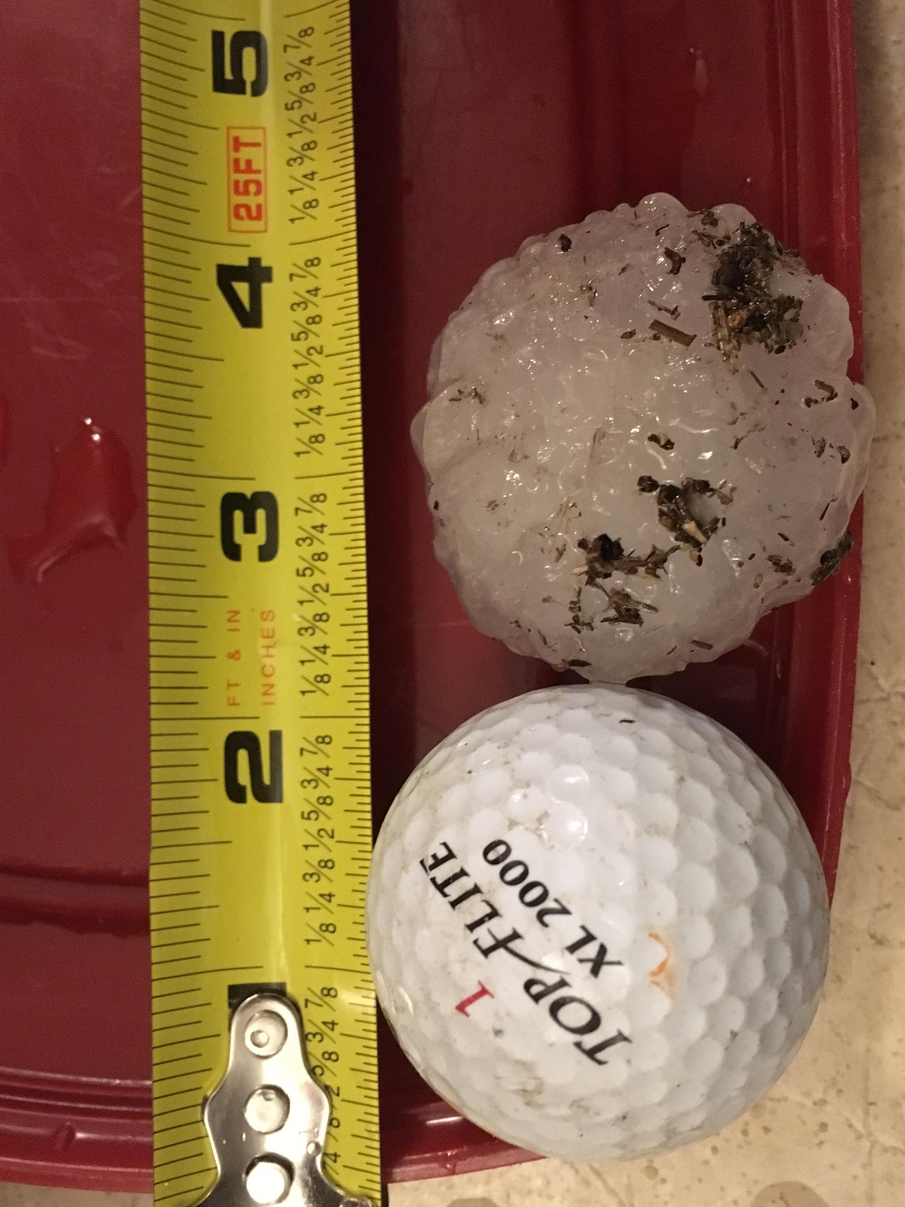
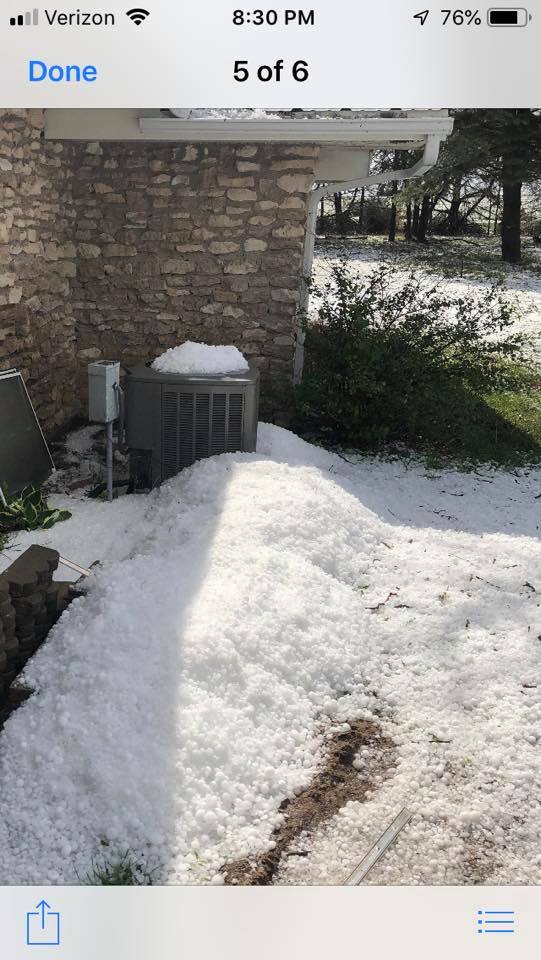
0415 PM HAIL 12 SSW TRENTON 40.00N 101.06W
05/17/2019 E3.00 INCH HITCHCOCK NE PUBLIC
PUBLIC REPORTED VIA FACEBOOK WITH A PICTURE
OF HAIL UP TO 3 INCHES IN DIAMETER ALONG HWY
25 AT THE KS/NE BORDER.
0400 PM HAIL 1 NE BENKELMAN 40.06N 101.53W
05/17/2019 M0.88 INCH DUNDY NE TRAINED SPOTTER
PEA TO NICKLE SIZED HAIL IN DOWNTOWN
BENKLEMAN.
0357 PM HAIL 3 NE BENKELMAN 40.08N 101.49W
05/17/2019 M1.75 INCH DUNDY NE LAW ENFORCEMENT
GOLF BALL SIZE HAIL REPORTED AT BENKLEMAN
GOLF COURSE.
0346 PM HAIL BENKELMAN 40.05N 101.53W
05/17/2019 M1.25 INCH DUNDY NE TRAINED SPOTTER
TRAINED SPOTTER REPORTED HALF DOLLAR SIZE
HAIL IN BENKELMAN.
0345 PM HAIL BENKELMAN 40.05N 101.53W
05/17/2019 E0.75 INCH DUNDY NE PUBLIC
PUBLIC REPORTED VIA FACEBOOK HAIL IN
DOWNTOWN BENKELMAN, NE UP TO JUST LARGER
THAN DIME SIZE,L WITH SEVERAL STONES AROUND
PEA SIZE.
0345 PM HAIL 1 SE BENKELMAN 40.04N 101.52W
05/17/2019 E2.00 INCH DUNDY NE PUBLIC
PUBLIC REPORTED VIA FACEBOOK HAIL UP TO 2
INCHES IN DIAMETER 1 MILE SE OF BENKELMAN.
REPORT INCLUDED A PICTURE WITH SEVERAL HAIL
STONES LARGER THAN A GOLF BALL.
0302 PM HAIL 13 N EDSON 39.51N 101.57W
05/17/2019 E2.00 INCH SHERMAN KS TRAINED SPOTTER
CORRECTS PREVIOUS HAIL REPORT FROM 13 N
EDSON. TRAINED SPOTTER REPORTED HAIL UP TO 2
INCHES IN DIAMETER, WITH PEA TO DIME SIZE
HAIL COVERING THE GROUND. ALSO REPORTED
DAMAGE TO PROPERTY INCLUDING BROKEN WINDOWS
AT THEIR HOUSE AND HAIL DAMAGE TO THEIR CAR.
0439 PM HAIL 10 NNW LUDELL 39.98N 101.06W
05/17/2019 M2.00 INCH RAWLINS KS PUBLIC
PUBLIC REPORTED VIA TWITTER HAIL UP TO 2.25
INCHES IN DIAMETER 1 MILE SOUTH OF THE KS/NE
BORDER ALONG HWY 25.
0432 PM HAIL 9 NNW LUDELL 39.97N 101.04W
05/17/2019 E1.75 INCH RAWLINS KS TRAINED SPOTTER
0338 PM TORNADO 7 SE MCDONALD 39.72N 101.28W
05/17/2019 RAWLINS KS TRAINED SPOTTER
CORRECTS PREVIOUS FUNNEL CLOUD REPORT FROM 7
SE MCDONALD. TRAINED SPOTTER REPORTED A
FUNNEL CLOUD ASSOCIATED WITH A SEVERE-WARNED
STORM 7 MILES SSW OF BEARDSLEY KS. MULTIPLE
SPOTTERS REPORTED A SPIN UP/ROTATION, BUT
THERE ARE CONFLICTING REPORTS ABOUT WHETHER
THIS WAS A BRIEF TORNADO OR NOT.
0337 PM HAIL MCDONALD 39.78N 101.37W
05/17/2019 M0.70 INCH RAWLINS KS LAW ENFORCEMENT
PEA TO DIME SIZE HAIL IN MCDONALD, KS.
0330 PM HAIL 10 N BIRD CITY 39.89N 101.53W
05/17/2019 E1.00 INCH CHEYENNE KS PUBLIC
CORRECTS PREVIOUS HAIL REPORT FROM 10 N BIRD
CITY TO 3:30 PM MDT. PUBLIC REPORTED VIA
FACEBOOK HAIL UP TO 1 INCH SIZE 10 MILES
NORTH OF BIRD CITY.
&&
$$
 |
Media use of NWS Web News Stories is encouraged! Please acknowledge the NWS as the source of any news information accessed from this site. |
|