Overview
|
A powerful spring storm brought a combination of rain, heavy snow, strong winds and a few thunderstorms to the region, mainly during the afternoon and evening of March 19, 2025. Precipitation initially began as rain before transitioning to wet, heavy snow as temperatures cooled. A narrow band of 6 to 9 inch snow amounts occurred from central through northeast Wisconsin, with a sharp drop off in snow amounts northwest of this band. A slower transition from rain to snow occurred across east-central Wisconsin as well which limited snow amounts in this area. |
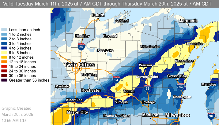 Estimated Snowfall Totals |
Snow/Ice
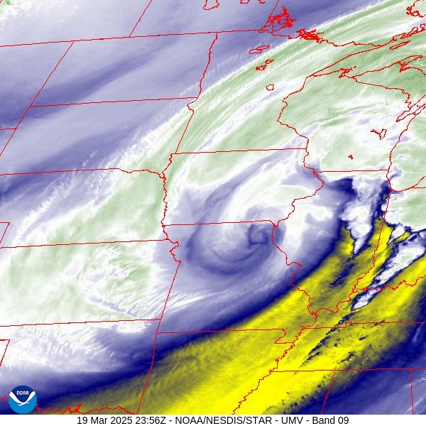
GOES 16 visible image showing swath of snow from Kansas to Wisconsin

...EVENT TOTAL SNOWFALL REPORTS...

Location                     Amount    Time/Date       Lat/Lon

...Wisconsin...

...Brown County...
4 ENE Green Bay              3.1 in    0900 AM 03/20   44.52N/87.92W
3 SE De Pere                 3.0 in    0700 AM 03/20   44.42N/88.01W
Denmark WWTP                 3.0 in    0800 AM 03/20   44.35N/87.81W
2 WNW Ashwaubenon            2.4 in    0700 AM 03/20   44.50N/88.11W
De Pere 2.0 ESE              2.2 in    0800 AM 03/20   44.43N/88.03W
Howard 1.7 SSW               1.8 in    0700 AM 03/20   44.55N/88.09W
2 WNW New Franken            1.6 in    0800 PM 03/19   44.54N/87.87W

...Calumet County...
Chilton 0.5 E                3.0 in    0700 AM 03/20   44.03N/88.15W
Brillion                     2.0 in    0630 AM 03/20   44.18N/88.07W

...Door County...
Ephraim 1 NE - WWTP          8.2 in    0730 AM 03/20   45.17N/87.15W
Sister Bay 1 N               8.0 in    0700 AM 03/20   45.20N/87.11W
Ellison Bay 0.0 SE           8.0 in    0715 AM 03/20   45.25N/87.07W
Egg Harbor 2.4 ENE           7.5 in    0700 AM 03/20   45.06N/87.25W
Fish Creek 1 E WWTP          7.3 in    0911 AM 03/20   45.12N/87.23W
Baileys Harbor 0.3 SSW       5.8 in    0700 AM 03/20   45.06N/87.13W
Forestville 4 E              4.3 in    0800 AM 03/20   44.70N/87.40W

...Florence County...
Aurora 0.7 E                 6.0 in    0630 AM 03/20   45.78N/88.09W
Spread Eagle 1 NW            5.0 in    0700 AM 03/20   45.89N/88.14W

...Forest County...
Armstrong Creek              5.0 in    1036 PM 03/19   45.67N/88.45W
Argonne 1.5 NW               2.7 in    0745 AM 03/20   45.67N/88.90W

...Kewaunee County...
Kewaunee                     5.9 in    0645 AM 03/20   44.46N/87.50W

...Langlade County...
White Lake 1.4 SE            7.1 in    0800 AM 03/20   45.15N/88.74W

...Lincoln County...
Merrill 7 W                  6.8 in    0600 AM 03/20   45.18N/89.85W
Merrill 8 W                  6.8 in    0600 AM 03/20   45.18N/89.85W
7 NNE Hamburg                5.5 in    0615 PM 03/19   45.18N/89.85W
Tomahawk 1.2 SSW             1.3 in    0700 AM 03/20   45.46N/89.73W

...Manitowoc County...
Two Rivers 2 NW              5.0 in    0700 AM 03/20   44.18N/87.58W
Two Rivers 2 NW              4.2 in    0700 AM 03/20   44.18N/87.58W
Millhome 2 E                 3.9 in    0700 AM 03/20   43.90N/87.91W
St. Nazianz 2 W              3.5 in    0700 AM 03/20   44.00N/87.96W
Two Rivers 1.2 N             3.2 in    0700 AM 03/20   44.17N/87.58W
Mishicot 0.1 NNW             2.0 in    0800 AM 03/20   44.23N/87.64W

...Marathon County...
1 SSE Evergreen              7.5 in    0842 PM 03/19   44.83N/89.63W
Evergreen 1.5 WSW            6.7 in    0700 AM 03/20   44.84N/89.67W
6 ESE Knowlton               6.1 in    0915 PM 03/19   44.69N/89.55W
Wausau 2.4 W                 6.0 in    0800 AM 03/20   44.96N/89.69W
Wausau 1.6 ENE               5.8 in    0600 AM 03/20   44.97N/89.62W
Wausau WSAW TV               5.5 in    1100 PM 03/19   44.95N/89.62W
Wausau 5.4 SSW               5.5 in    0700 AM 03/20   44.89N/89.69W
Wausau 1 ENE                 5.3 in    0700 AM 03/20   44.97N/89.61W
Dancy 1 NNW                  5.2 in    0700 AM 03/20   44.70N/89.70W
2 N Wausau                   5.0 in    0715 PM 03/19   44.99N/89.63W
Stratford 1 NW               5.0 in    0619 AM 03/20   44.82N/90.09W
Wausau 1.6 NE                4.5 in    0700 AM 03/20   44.98N/89.62W
Spencer - Wwtp               3.5 in    0730 AM 03/20   44.75N/90.29W

...Marinette County...
Athelstane 1.6 E             9.0 in    0600 AM 03/20   45.42N/88.06W
Amberg 1.3 SW                7.5 in    0800 AM 03/20   45.49N/88.01W
Amberg 9 E                   7.5 in    0857 AM 03/20   45.48N/87.81W
Wausaukee 1.6 NW             7.2 in    0747 AM 03/20   45.38N/87.96W
Menominee 1.6 S              5.4 in    0730 AM 03/20   45.10N/87.62W
Peshtigo 1 S                 5.0 in    0730 AM 03/20   45.03N/87.74W
Crivitz - WPS                5.0 in    0832 AM 03/20   45.24N/88.01W

...Oconto County...
Mountain 0.9 E               8.0 in    0700 AM 03/20   45.18N/88.46W
Oconto Falls 1.0 SE          4.9 in    0520 AM 03/20   44.86N/88.13W
2 E Sampson                  3.2 in    0330 AM 03/20   44.76N/88.14W
Shawano Lake 6 NNE           3.0 in    0800 AM 03/20   44.89N/88.48W

...Oneida County...
Rhinelander 2 SW             1.0 in    0730 AM 03/20   45.60N/89.45W
Rhinelander 5.5 NW           0.5 in    0530 AM 03/20   45.70N/89.48W
Rhinelander 5 N               T in     0730 AM 03/20   45.71N/89.42W

...Outagamie County...
Shiocton 0.6 NW              5.0 in    0730 AM 03/20   44.44N/88.58W
Appleton 3.0 ESE             4.0 in    0600 AM 03/20   44.25N/88.34W
Appleton 2.3 NW              3.5 in    0430 AM 03/20   44.29N/88.43W
Appleton                     2.8 in    0500 AM 03/20   44.28N/88.44W
New London 4.1 N             1.8 in    0600 AM 03/20   44.45N/88.73W

...Portage County...
Stevens Point                7.7 in    0705 AM 03/20   44.51N/89.59W
Plover 1.4 S                 6.7 in    0700 AM 03/20   44.44N/89.55W
Rosholt                      5.9 in    0730 AM 03/20   44.63N/89.31W
Almond 5 NE                  4.7 in    0800 AM 03/20   44.31N/89.35W
Rudolph 1 NNE                3.5 in    0500 AM 03/20   44.53N/89.79W
Wisconsin Rapids 9.8 SE      3.0 in    0700 AM 03/20   44.28N/89.71W

...Shawano County...
Birnamwood 5.9 ENE           7.2 in    0700 AM 03/20   44.95N/89.09W
Pella 3 SE                   6.0 in    0530 AM 03/20   44.74N/88.74W
1 ESE Shawano Lake           5.0 in    0839 PM 03/19   44.80N/88.50W
Shawano 2 SSW                5.0 in    0800 AM 03/20   44.76N/88.62W
1 S Shawano                  4.5 in    0830 AM 03/20   44.76N/88.59W
Pulaski 3.7 W                2.5 in    0722 AM 03/20   44.67N/88.31W

...Waupaca County...
Waupaca 1.4 W                2.2 in    0600 AM 03/20   44.35N/89.10W
Manawa 3.6 SSW               2.0 in    0700 AM 03/20   44.41N/88.95W

...Waushara County...
Wild Rose 0.5 E              4.6 in    0500 AM 03/20   44.18N/89.24W
Berlin WWTP                  2.0 in    0700 AM 03/20   43.99N/88.94W

...Winnebago County...
2 NNE Oshkosh                4.5 in    0756 AM 03/20   44.03N/88.53W
Neenah 1.1 ENE               3.5 in    0700 AM 03/20   44.17N/88.45W
Menasha 0.3 W                3.4 in    0700 AM 03/20   44.21N/88.44W
Oshkosh                      3.0 in    0700 AM 03/20   44.03N/88.56W
Oshkosh 1.6 ESE              2.3 in    0700 AM 03/20   44.01N/88.52W
Oshkosh Southeast            2.3 in    0700 AM 03/20   44.01N/88.52W
Omro 1 WSW                   1.2 in    0700 AM 03/20   44.02N/88.78W

...Wood County...
Marshfield 5.6 SSW           8.0 in    0700 AM 03/20   44.59N/90.20W
Marshfield                   7.0 in    0644 PM 03/19   44.66N/90.16W
1 ENE Marshfield             7.0 in    0833 PM 03/19   44.66N/90.14W
Hewitt 0.8 N                 7.0 in    0730 AM 03/20   44.64N/90.13W
Marshfield 6.5 S             6.0 in    0800 AM 03/20   44.57N/90.18W
Wisconsin Rapids 4.5 SSE     5.5 in    0600 AM 03/20   44.34N/89.79W
Port Edwards 2 E             5.0 in    0645 AM 03/20   44.34N/89.78W
Pittsville - WWTP            4.0 in    0700 AM 03/20   44.44N/90.13W

Observations are collected from a variety of sources with varying
equipment and exposures. We thank all volunteer weather observers
for their dedication. Not all data listed are considered official.

$$
Wind Reports
...HIGHEST WIND GUSTS...

Location                     Speed     Time/Date       Lat/Lon/Elev (ft.)

...Wisconsin...

...Brown County...
Green Bay - Leo Frigo Bridge 46 MPH    0427 PM 03/19   44.53N/87.99W/583
Green Bay Airport            44 MPH    0820 PM 03/19   44.48N/88.13W/686
Wrightstown                  42 MPH    0428 PM 03/19   44.33N/88.17W/652
De Pere                      40 MPH    1015 AM 03/19   44.33N/87.97W/895
De Pere                      35 MPH    1020 PM 03/19   44.44N/88.05W/643
Green Bay 1 N                34 MPH    0600 PM 03/19   44.54N/88.00W
Ashwaubenon                  32 MPH    0315 PM 03/19   44.49N/88.04W/598
Green Bay                    31 MPH    0500 PM 03/19   44.49N/88.09W/652

...Calumet County...
Forest Junction              40 MPH    1057 PM 03/19   44.21N/88.21W/833
Brillion                     35 MPH    0915 PM 03/19   44.10N/88.05W/833

...Door County...
Sturgeon Bay Airport         41 MPH    0914 PM 03/19   44.85N/87.42W/685
Chambers Island 1 NNW        39 MPH    0540 PM 03/19   45.20N/87.36W
Ephraim Airport              37 MPH    0355 PM 03/19   45.13N/87.18W/747
Carlsville 4.1 SW (MAWN)     34 MPH    0945 PM 03/19   44.88N/87.33W/731
Washington Island Airport    31 MPH    0555 PM 03/19   45.38N/86.92W/658

...Florence County...
Sth 70 At Sth 139            31 MPH    1007 PM 03/19   45.97N/88.65W/1590

...Kewaunee County...
Kewaunee MET, WI             47 MPH    1124 PM 03/19   44.47N/87.50W/583
Kewaunee MET, WI             43 MPH    0518 PM 03/19   44.47N/87.50W/583
Luxemburg 2.0 NE (MAWN)      33 MPH    0625 PM 03/19   44.56N/87.65W/714

...Langlade County...
Antigo Airport               36 MPH    0515 PM 03/19   45.15N/89.12W/1518
Antigo 2 ENE                 32 MPH    0505 PM 03/19   45.16N/89.11W/1499

...Lincoln County...
Merrill Airport              31 MPH    0435 PM 03/19   45.20N/89.72W/1310

...Manitowoc County...
Manitowoc                    45 MPH    0647 PM 03/19   44.11N/87.69W/647
Manitowoc Airport            45 MPH    1056 PM 03/19   44.12N/87.67W/618
Valders                      41 MPH    0355 PM 03/19   44.00N/87.82W/810
MANITOWOC                    36 MPH    0155 PM 03/19   44.07N/87.69W/669
Reedsville                   31 MPH    0815 PM 03/19   44.23N/87.96W/869

...Marathon County...
Mosinee Airport              35 MPH    0750 PM 03/19   44.78N/89.67W/1282
Wausau Airport               33 MPH    0339 PM 03/19   44.93N/89.62W/1208
Moon 6 SW                    31 MPH    0905 PM 03/19   44.70N/89.87W/1149
Marshfield                   31 MPH    0755 PM 03/19   44.76N/90.10W/1312

...Oconto County...
Breed 5 NE                   32 MPH    0930 PM 03/19   45.12N/88.37W/910

...Oneida County...
Rhinelander Airport          36 MPH    1008 PM 03/19   45.63N/89.48W/1599
Rhinelander                  32 MPH    0550 PM 03/19   45.65N/89.27W/1598

...Outagamie County...
Appleton Airport             38 MPH    0745 PM 03/19   44.27N/88.52W/888
Grand Chute                  31 MPH    0414 PM 03/19   44.31N/88.42W/801

...Portage County...
Plover                       35 MPH    0237 PM 03/19   44.44N/89.55W/1082
Stevens Point Airport        31 MPH    0235 PM 03/19   44.55N/89.53W/1106

...Shawano County...
Shawano Airport              30 MPH    0515 PM 03/19   44.78N/88.57W/814
Wittenberg                   30 MPH    0405 PM 03/19   44.87N/89.02W/1131

...Vilas County...
Manitowish Waters            33 MPH    0210 PM 03/19   46.08N/89.84W/1613
Land O Lakes Airport         32 MPH    1135 PM 03/19   46.15N/89.22W/1694

...Waupaca County...
Waupaca Airport              33 MPH    0315 PM 03/19   44.33N/89.02W/809
Clintonville Airport         32 MPH    0415 PM 03/19   44.62N/88.73W/816

...Waushara County...
Wautoma Airport              37 MPH    0242 PM 03/19   44.03N/89.30W/855

...Winnebago County...
Oshkosh Airport              49 MPH    0802 PM 03/19   43.97N/88.55W/794

...Wood County...
Marshfield Airport           38 MPH    0228 PM 03/19   44.63N/90.18W/1241
Wisconsin Rapids Airport     35 MPH    0203 PM 03/19   44.37N/89.83W/1020
Wood Co. Sth 13 Eb At Sth 80 30 MPH    0210 PM 03/19   44.45N/90.13W/1037

...Maritime Stations...
Gills Rock 1 ENE             38 MPH    0900 PM 03/19   45.29N/86.98W

Observations are collected from a variety of sources with varying
equipment and exposures. We thank all volunteer weather observers
for their dedication. Not all data listed are considered official.

$$
Radar/Satellite:
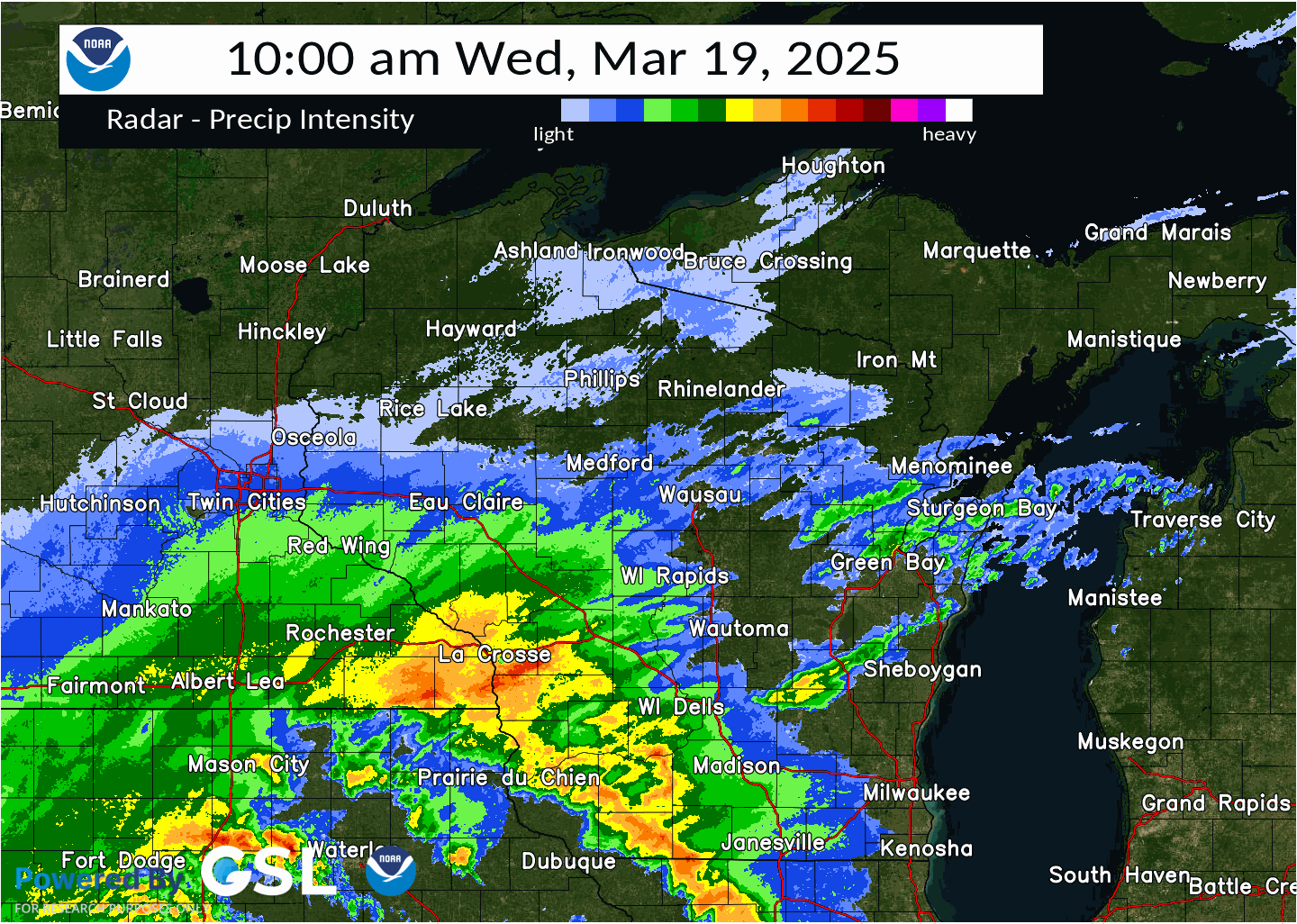
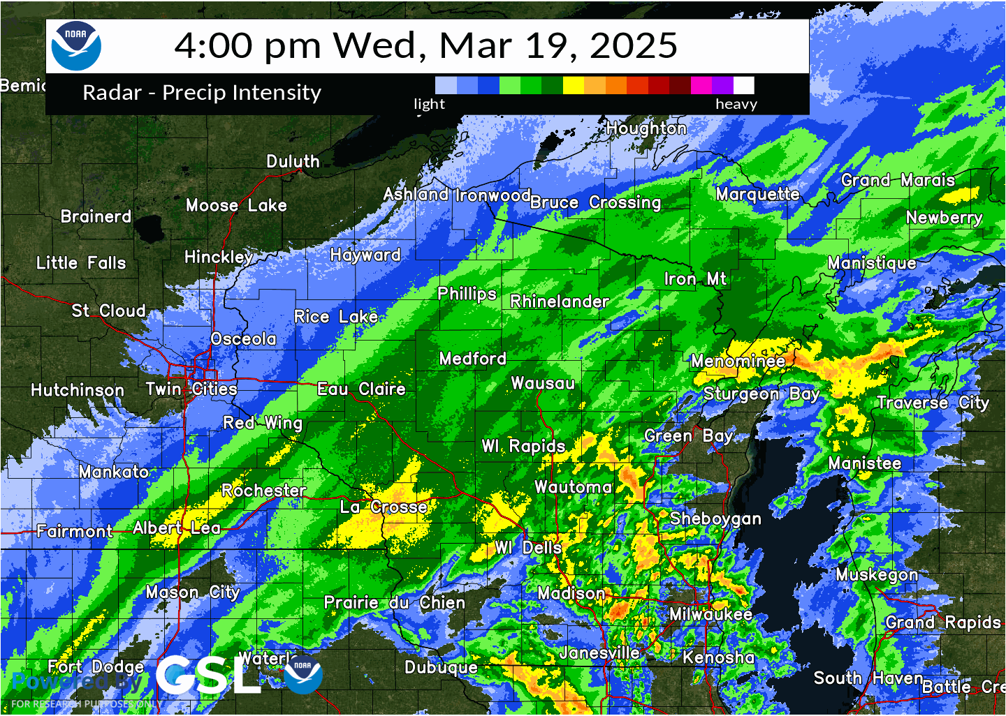
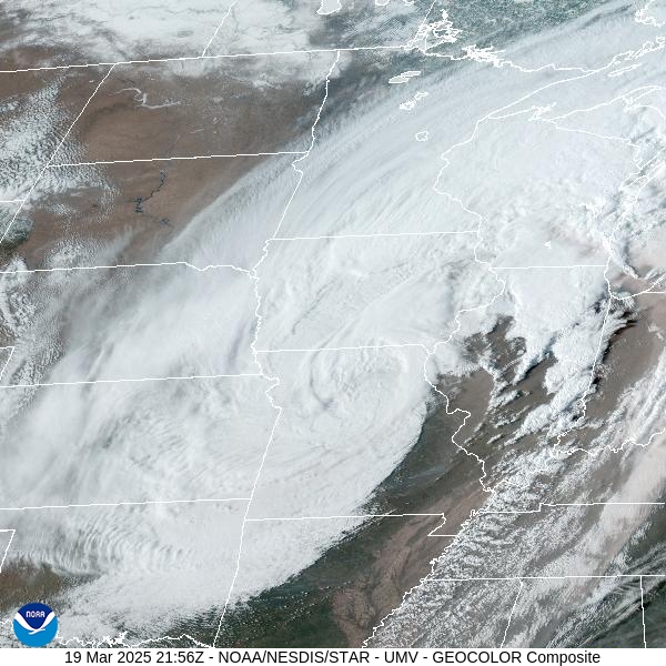
Radar and Satellite Displays
 |
 |
 |
 |
| Radar reflectivity 10 am - 4 pm Mar 19 | Radar reflectivity 4 pm - 10 pm Mar 19 | GOES 16 Geocolor image at 4:56 PM Mar 19 | GOES 16 Water Vapor image at 6:56 PM Mar 19 |
Rain Reports
...PRECIPITATION REPORTS FROM THE PAST 24 HOURS...

Location                     Amount    Time/Date       Lat/Lon

...Wisconsin...

...Brown County...
Denmark WWTP                 0.72 in   0800 AM 03/20   44.35N/87.81W
Green Bay 4.9 SSW            0.71 in   0700 AM 03/20   44.46N/88.03W
Howard 1.7 SSW               0.60 in   0700 AM 03/20   44.55N/88.09W
Green Bay Airport            0.54 in   0853 AM 03/20   44.48N/88.13W
Green Bay                    0.45 in   1015 AM 03/20   44.50N/88.01W
Green Bay                    0.44 in   1023 AM 03/20   44.58N/88.09W
De Pere                      0.43 in   1020 AM 03/20   44.44N/88.05W
De Pere                      0.43 in   1028 AM 03/20   44.44N/88.09W
Green Bay                    0.41 in   1030 AM 03/20   44.51N/88.01W
Wrightstown                  0.36 in   1025 AM 03/20   44.33N/88.17W
Denmark                      0.36 in   1030 AM 03/20   44.39N/87.86W
De Pere                      0.33 in   1030 AM 03/20   44.37N/88.07W
Green Bay                    0.31 in   1015 AM 03/20   44.49N/88.09W
Denmark 1 NNE                0.22 in   1035 AM 03/20   44.35N/87.83W

...Calumet County...
Chilton 0.5 E                0.63 in   0700 AM 03/20   44.03N/88.15W
Chilton 1 W                  0.56 in   1034 AM 03/20   44.03N/88.17W
Brillion                     0.45 in   0630 AM 03/20   44.18N/88.07W

...Door County...
Ellison Bay 0.0 SE           1.25 in   0715 AM 03/20   45.25N/87.07W
Sister Bay 1 N               1.20 in   0700 AM 03/20   45.20N/87.11W
Fish Creek 1 E WWTP          1.05 in   0911 AM 03/20   45.12N/87.23W
Baileys Harbor 0.3 SSW       1.01 in   0700 AM 03/20   45.06N/87.13W
Forestville 4 E              1.00 in   0800 AM 03/20   44.70N/87.40W
Egg Harbor 2.4 ENE           0.82 in   0700 AM 03/20   45.06N/87.25W
Ephraim 1 NE - WWTP          0.82 in   0730 AM 03/20   45.17N/87.15W

...Florence County...
Spread Eagle 1 NW            0.75 in   0700 AM 03/20   45.89N/88.14W
Aurora 0.7 E                 0.73 in   0630 AM 03/20   45.78N/88.09W

...Forest County...
Argonne 1.5 NW               0.21 in   0745 AM 03/20   45.67N/88.90W

...Kewaunee County...
Kewaunee                     0.47 in   0645 AM 03/20   44.46N/87.50W
Rankin 2 E                   0.35 in   1034 AM 03/20   44.60N/87.44W

...Langlade County...
White Lake 1.4 SE            0.78 in   0800 AM 03/20   45.15N/88.74W

...Lincoln County...
Merrill 7 W                  0.58 in   0600 AM 03/20   45.18N/89.85W
Merrill 8 W                  0.58 in   0600 AM 03/20   45.18N/89.85W
Merrill 14.1 W               0.44 in   0700 AM 03/20   45.15N/89.99W

...Manitowoc County...
Two Rivers 2 NW              1.05 in   0700 AM 03/20   44.18N/87.58W
Two Rivers 1.2 N             0.94 in   0700 AM 03/20   44.17N/87.58W
St. Nazianz 2 W              0.86 in   0700 AM 03/20   44.00N/87.96W
Manitowoc                    0.82 in   0607 AM 03/20   44.11N/87.69W
Two Rivers 2 NW              0.78 in   0700 AM 03/20   44.18N/87.58W
Mishicot 0.1 NNW             0.77 in   0800 AM 03/20   44.23N/87.64W
Millhome 2 E                 0.68 in   0700 AM 03/20   43.90N/87.91W
Two Rivers                   0.52 in   1028 AM 03/20   44.15N/87.56W

...Marathon County...
Wausau 2.4 W                 0.72 in   0800 AM 03/20   44.96N/89.69W
Evergreen 1.5 WSW            0.70 in   0700 AM 03/20   44.84N/89.67W
Rothschild 0.5 ENE           0.67 in   0700 AM 03/20   44.89N/89.61W
Dancy 1 NNW                  0.55 in   0700 AM 03/20   44.70N/89.70W
Wausau 1 ENE                 0.53 in   0700 AM 03/20   44.97N/89.61W
Wausau 1.6 NE                0.51 in   0700 AM 03/20   44.98N/89.62W
Wausau 1.6 ENE               0.45 in   0600 AM 03/20   44.97N/89.62W
Wausau 5.4 SSW               0.45 in   0700 AM 03/20   44.89N/89.69W
Stratford 1 NW               0.30 in   0619 AM 03/20   44.82N/90.09W

...Marinette County...
Athelstane 1.6 E             0.92 in   0600 AM 03/20   45.42N/88.06W
Peshtigo 1 S                 0.89 in   0730 AM 03/20   45.03N/87.74W
Wausaukee 1.6 NW             0.72 in   0747 AM 03/20   45.38N/87.96W
Amberg 9 E                   0.55 in   0857 AM 03/20   45.48N/87.81W
Crivitz - WPS                0.52 in   0832 AM 03/20   45.24N/88.01W
Menominee 1.6 S              0.50 in   0730 AM 03/20   45.10N/87.62W
Wausaukee 2 NW               0.50 in   1005 AM 03/20   45.39N/87.97W

...Oconto County...
Oconto Falls 1.0 SE          0.67 in   0520 AM 03/20   44.86N/88.13W
Mountain 0.9 E               0.67 in   0700 AM 03/20   45.18N/88.46W

...Oneida County...
Rhinelander 2 SW             0.06 in   0730 AM 03/20   45.60N/89.45W
Rhinelander Airport          0.04 in   0853 AM 03/20   45.63N/89.48W
Rhinelander 5.5 NW           0.03 in   0530 AM 03/20   45.70N/89.48W

...Outagamie County...
Appleton                     0.86 in   1007 AM 03/20   44.29N/88.46W
Appleton 2.3 NW              0.83 in   0430 AM 03/20   44.29N/88.43W
Appleton 3.0 ESE             0.80 in   0600 AM 03/20   44.25N/88.34W
New London 4.1 N             0.69 in   0600 AM 03/20   44.45N/88.73W
Appleton                     0.67 in   0500 AM 03/20   44.28N/88.44W
Shiocton 0.6 NW              0.50 in   0730 AM 03/20   44.44N/88.58W
Grand Chute                  0.47 in   1028 AM 03/20   44.31N/88.42W
Kaukauna                     0.38 in   1030 AM 03/20   44.33N/88.30W
Seymour                      0.28 in   1030 AM 03/20   44.54N/88.25W

...Portage County...
Wisconsin Rapids 9.8 SE      1.07 in   0700 AM 03/20   44.28N/89.71W
Wisconsin Rapids 6.6 ESE     0.90 in   0700 AM 03/20   44.35N/89.72W
Almond 5 NE                  0.90 in   0800 AM 03/20   44.31N/89.35W
Stevens Point                0.77 in   0705 AM 03/20   44.51N/89.59W
Plover 1.4 S                 0.72 in   0700 AM 03/20   44.44N/89.55W
Plover                       0.72 in   1027 AM 03/20   44.44N/89.55W
Rosholt                      0.55 in   0730 AM 03/20   44.63N/89.31W
Rudolph 1 NNE                0.24 in   0500 AM 03/20   44.53N/89.79W

...Shawano County...
Birnamwood 5.9 ENE           1.23 in   0700 AM 03/20   44.95N/89.09W
Pella 3 SE                   0.92 in   0530 AM 03/20   44.74N/88.74W
Shawano 2 SSW                0.84 in   0800 AM 03/20   44.76N/88.62W
Shawano 1.6 NW               0.74 in   0700 AM 03/20   44.79N/88.62W
Pulaski 3.7 W                0.55 in   0722 AM 03/20   44.67N/88.31W

...Waupaca County...
Fremont                      0.59 in   1028 AM 03/20   44.28N/88.82W
Waupaca 1.4 W                0.50 in   0600 AM 03/20   44.35N/89.10W
Waupaca Airport              0.49 in   1015 AM 03/20   44.33N/89.02W
Clintonville Airport         0.46 in   1015 AM 03/20   44.62N/88.73W
Manawa 3.6 SSW               0.30 in   0700 AM 03/20   44.41N/88.95W

...Waushara County...
Wautoma 0.4 SW               0.91 in   0735 AM 03/20   44.06N/89.30W
Wild Rose 0.5 E              0.86 in   0500 AM 03/20   44.18N/89.24W
Wautoma 1 WSW                0.79 in   1012 AM 03/20   44.06N/89.29W
Wautoma Airport              0.37 in   0856 AM 03/20   44.03N/89.30W

...Winnebago County...
Menasha 1.5 W                1.39 in   1000 AM 03/20   44.20N/88.47W
Omro                         1.31 in   1025 AM 03/20   44.03N/88.75W
Neenah 1.1 ENE               1.03 in   0700 AM 03/20   44.17N/88.45W
Appleton 2.3 SW              0.92 in   0700 AM 03/20   44.24N/88.43W
Oshkosh                      0.77 in   0700 AM 03/20   44.03N/88.56W
Oshkosh 1.6 ESE              0.72 in   0700 AM 03/20   44.01N/88.52W
Oshkosh Southeast            0.72 in   0700 AM 03/20   44.01N/88.52W
Omro 1 WSW                   0.64 in   0700 AM 03/20   44.02N/88.78W
Oshkosh 1.5 SSE              0.64 in   0700 AM 03/20   44.00N/88.54W
Menasha 0.3 W                0.63 in   0700 AM 03/20   44.21N/88.44W
Oshkosh Airport              0.62 in   0853 AM 03/20   43.97N/88.55W

...Wood County...
Port Edwards 1 SE            1.25 in   0700 AM 03/20   44.34N/89.84W
New Rome 4 ENE               0.83 in   1005 AM 03/20   44.26N/89.81W
Port Edwards 2 E             0.81 in   0645 AM 03/20   44.34N/89.78W
Rudolph 2.1 W                0.79 in   0700 AM 03/20   44.50N/89.84W
Hewitt 0.8 N                 0.63 in   0730 AM 03/20   44.64N/90.13W
Marshfield 5.6 SSW           0.62 in   0700 AM 03/20   44.59N/90.20W
Wisconsin Rapids Airport     0.60 in   0854 AM 03/20   44.37N/89.83W
Pittsville - WWTP            0.55 in   0700 AM 03/20   44.44N/90.13W
Marshfield Airport           0.54 in   0854 AM 03/20   44.63N/90.18W
Marshfield 6.5 S             0.53 in   0800 AM 03/20   44.57N/90.18W

Observations are collected from a variety of sources with varying
equipment and exposures. We thank all volunteer weather observers
for their dedication. Not all data listed are considered official.

$$
 |
Media use of NWS Web News Stories is encouraged! Please acknowledge the NWS as the source of any news information accessed from this site. |
|

