Overview
|
Two rounds of severe storms raced across portions of central and northern Wisconsin on April 9th and April 10th. The first round of storms affected northern Wisconsin between about 5 pm CDT and 8 pm CDT producing hail up to 1 inch in diameter. The second and more intense round of storms raced across central and north-central Wisconsin between about 1130 pm CDT April 9th and 3 am CDT April 10th producing hail up to 1.75 inches in diameter, straight line wind damage and at least one tornado. The hardest hit area was just west of Wausau where a brief tornado touched down about 6 miles WNW of town. The tornado caused significant damage to two structures and minor damage to several others along its 1/2 mile path. A preliminary NWS damage survey estimated maximum winds of 105 mph (EF1). Microbursts (straight-line thunderstorm winds) produced significant wind damage near Minocqua in Oneida County and near Marshfield in northern Wood County. Winds were estimated over 75 mph in these storms. Please click on the tabs below for more information. |
 |
Tornado Information
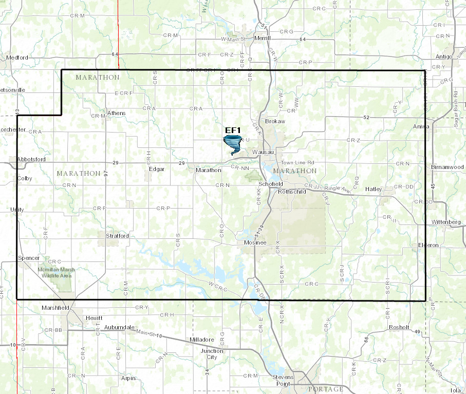
There was a confirmed tornado just WNW of Wausau.
|
Tornado - Marathon County
Track Map
|
||||||||||||||||
The Enhanced Fujita (EF) Scale classifies tornadoes into the following categories:
| EF0 Weak 65-85 mph |
EF1 Moderate 86-110 mph |
EF2 Significant 111-135 mph |
EF3 Severe 136-165 mph |
EF4 Extreme 166-200 mph |
EF5 Catastrophic 200+ mph |
 |
|||||
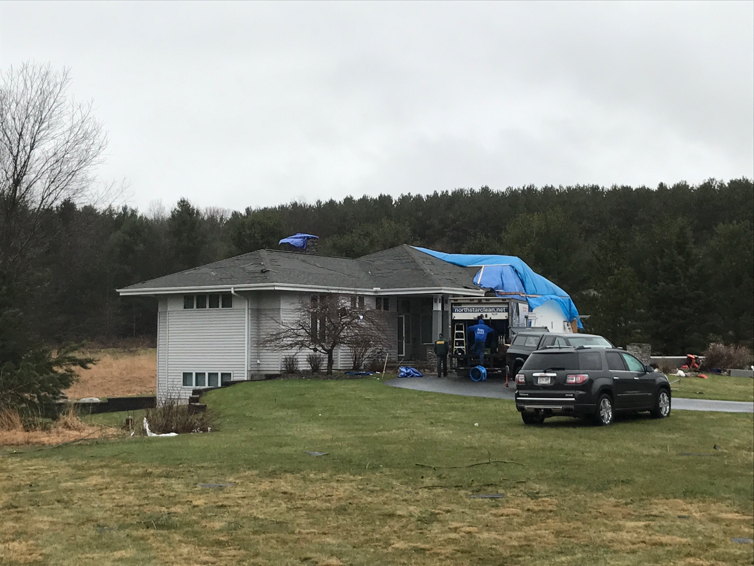
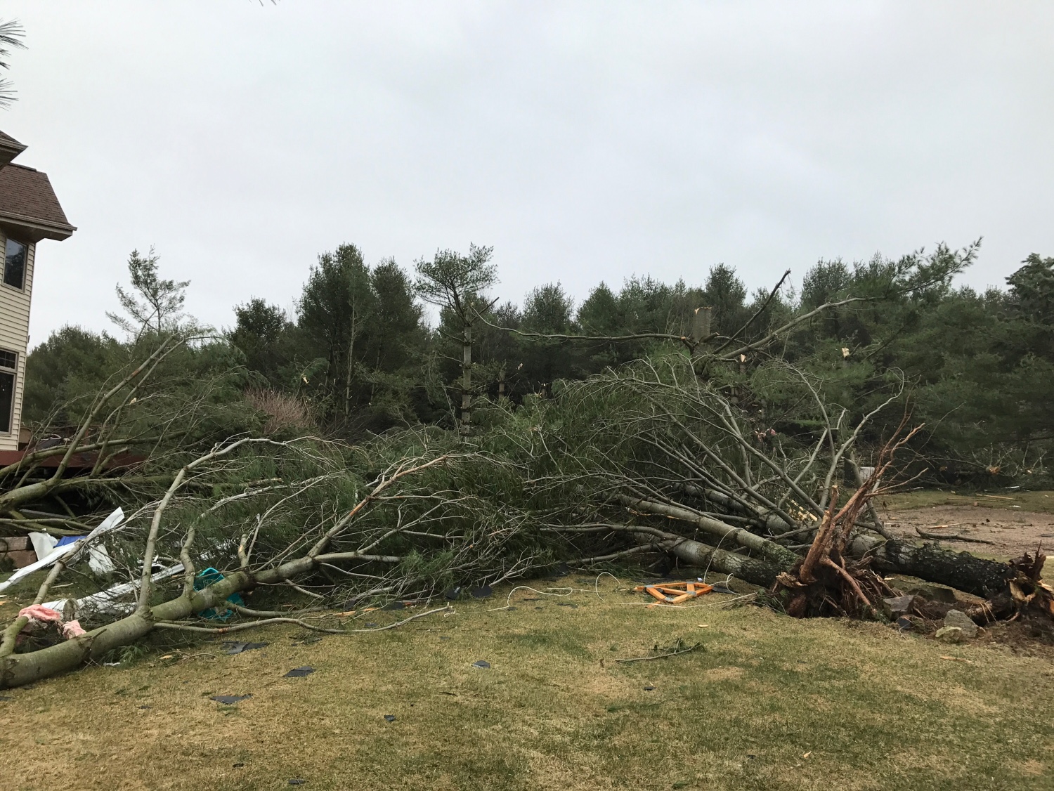
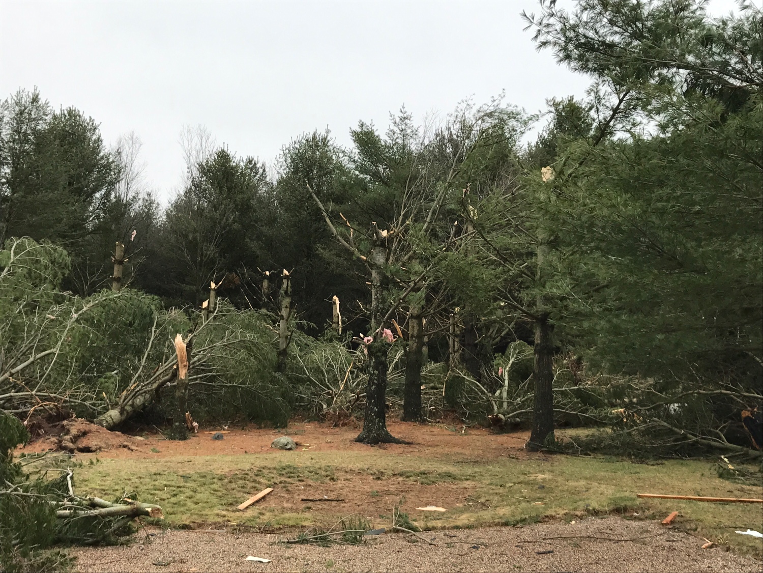
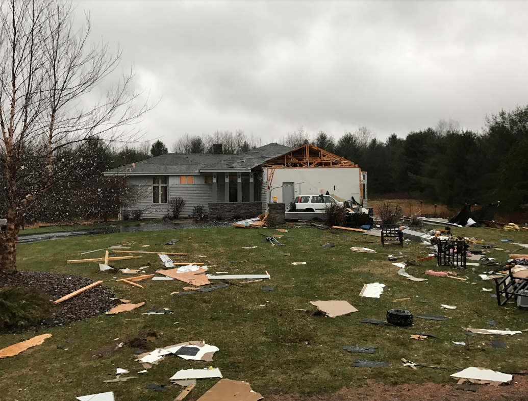
Damage Photos
Here are some photos from the severe storms. Click photos for a larger image.
 |
 |
 |
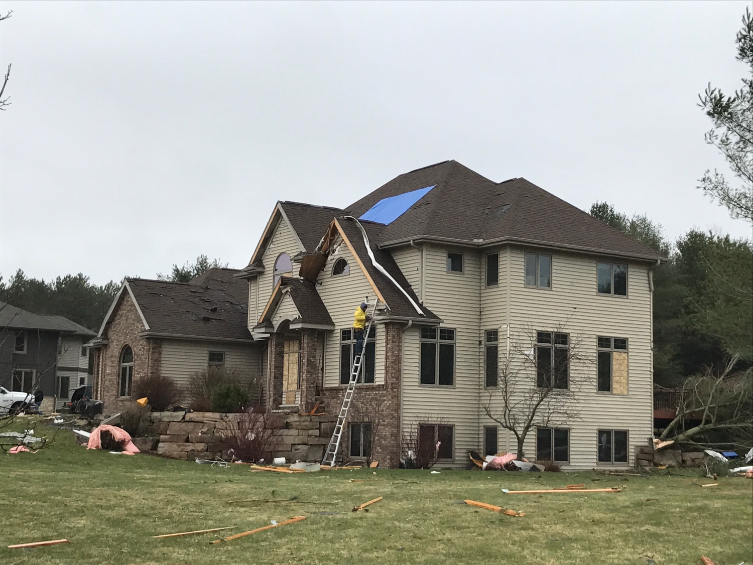 |
| Here are some photos from the tornado just west of Wausau | |||
 |
 |
||
| Courtesy of WAOW | Courtesy of WAOW |
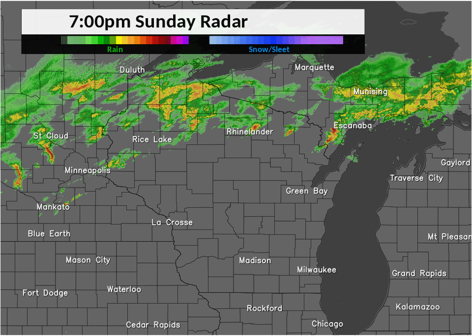
Storm Reports
Here is a map of the reported severe weather on April 9/10.
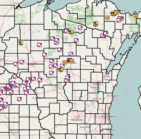
Here are the preliminary storm reports received by the NWS Green Bay.
PRELIMINARY LOCAL STORM REPORT...SUMMARY
NATIONAL WEATHER SERVICE GREEN BAY WI
230 AM CDT MON APR 10 2017

..TIME...   ...EVENT...      ...CITY LOCATION...     ...LAT.LON...
..DATE...   ....MAG....      ..COUNTY LOCATION..ST.. ...SOURCE....
            ..REMARKS..

0503 PM     HEAVY RAIN       RHINELANDER             45.63N 89.41W
04/09/2017  M1.08 INCH       ONEIDA             WI   ASOS

            LAST 2 HOURS. MDT RAIN CONTINUES.

0606 PM     HAIL             W TRIPOLI               45.55N 90.00W
04/09/2017  M1.00 INCH       LINCOLN            WI   PUBLIC

0625 PM     HAIL             CALDRON FALLS RESERVOIR 45.35N 88.25W
04/09/2017  M0.88 INCH       MARINETTE          WI   CO-OP OBSERVER

0630 PM     HAIL             8 N TOMAHAWK            45.58N 89.73W
04/09/2017  M1.00 INCH       ONEIDA             WI   TRAINED SPOTTER

0635 PM     HAIL             HARSHAW                 45.66N 89.65W
04/09/2017  M0.75 INCH       ONEIDA             WI   PUBLIC

0645 PM     HAIL             W RHINELANDER           45.63N 89.41W
04/09/2017  M0.75 INCH       ONEIDA             WI   PUBLIC

0648 PM     HAIL             3 NW RHINELANDER        45.66N 89.45W
04/09/2017  E1.00 INCH       ONEIDA             WI   PUBLIC

            IN NEWBOLD

0652 PM     HAIL             4 N RHINELANDER         45.69N 89.41W
04/09/2017  M0.75 INCH       ONEIDA             WI   TRAINED SPOTTER

0655 PM     HAIL             SUGAR CAMP              45.78N 89.30W
04/09/2017  M1.00 INCH       ONEIDA             WI   PUBLIC

            VIA WSAW TV-7.

0821 PM     HAIL             HOMESTEAD               45.78N 88.20W
04/09/2017  M0.25 INCH       FLORENCE           WI   LAW ENFORCEMENT

1128 PM     TSTM WND GST     LAC DU FLAMBEAU         45.96N 89.88W
04/09/2017  E50.00 MPH       VILAS              WI   LAW ENFORCEMENT

            RELAYED FROM A DNR OFFICIAL

1128 PM     HAIL             LAC DU FLAMBEAU         45.96N 89.88W
04/09/2017  E1.75 INCH       VILAS              WI   LAW ENFORCEMENT

1130 PM     HAIL             2 S LAC DU FLAMBEAU     45.93N 89.88W
04/09/2017  M1.00 INCH       VILAS              WI   TRAINED SPOTTER

            WINDS ESTIMATED 40-45MPH

1130 PM     TSTM WND DMG     WOODRUFF                45.90N 89.69W
04/09/2017                   ONEIDA             WI   TRAINED SPOTTER

            TREES DOWN. DELAYED REPORT. TIME ESTIMATED

1202 AM     HAIL             CONOVER                 46.04N 89.25W
04/10/2017  M0.88 INCH       VILAS              WI   TRAINED SPOTTER

1230 AM     TORNADO          6 WNW WAUSAU            44.98N 89.74W
04/10/2017                   MARATHON           WI   NWS STORM SURVEY

            PRELIMINARY TORNADO INFORMATION. START TIME AROUND
            1230AM. ESTIMATED 100 YARDS WIDE. PEAK WIND ESTIMATED 100
            MPH. 100 MATURE PINE TREES SNAPPED. SIGNIFICANT DAMAGE TO
            TWO STRUCTURES WITH MINOR DAMAGE TO OTHERS. MORE DETAILS
            TO FOLLOW.
1230 AM     HAIL             1 W RHINELANDER         45.63N 89.43W
04/10/2017  E0.75 INCH       ONEIDA             WI   PUBLIC

            RELAYED BY WSAW-TV

1234 AM     HAIL             MARSHFIELD              44.66N 90.16W
04/10/2017  M0.50 INCH       WOOD               WI   TRAINED SPOTTER

1235 AM     HAIL             STRATFORD               44.79N 90.08W
04/10/2017  E0.75 INCH       MARATHON           WI   PUBLIC

            RELAYED BY WSAW-TV

1239 AM     TSTM WND DMG     MARSHFIELD              44.66N 90.16W
04/10/2017                   WOOD               WI   LAW ENFORCEMENT

            ROOF BLOWN OFF TRAILER. DELAYED REPORT

1245 AM     TSTM WND GST     EDGAR                   44.91N 89.96W
04/10/2017  E50.00 MPH       MARATHON           WI   TRAINED SPOTTER

            ALSO 1/4-1/2 INCH HAIL

1255 AM     HAIL             1 W WAUSAU              44.96N 89.65W
04/10/2017  E0.88 INCH       MARATHON           WI   LAW ENFORCEMENT

0101 AM     TSTM WND GST     WAUSAU                  44.96N 89.63W
04/10/2017  M52.00 MPH       MARATHON           WI   ASOS

            52 MPH GUST ON AUW ASOS

0101 AM     TSTM WND GST     WAUSAU                  44.96N 89.63W
04/10/2017  M56.00 MPH       MARATHON           WI   OFFICIAL NWS OBS

0105 AM     TSTM WND GST     WAUSAU                  44.96N 89.63W
04/10/2017  E50.00 MPH       MARATHON           WI   TRAINED SPOTTER

            ALSO PEA TO NICKEL SIZED HAIL. SOME POWER OUTAGES
            REPORTED.

0105 AM     TSTM WND DMG     WAUSAU                  44.96N 89.63W
04/10/2017                   MARATHON           WI   TRAINED SPOTTER

            TREES DOWN ON NORTH SIDE OF WAUSAU. PEA-SIZED HAIL.
            ESTIMATED 45-55 MPH WINDS

0115 AM     HAIL             MERRILL                 45.18N 89.68W
04/10/2017  E0.88 INCH       LINCOLN            WI   TRAINED SPOTTER

            ALSO 50 MPH WIND GUSTS

0153 AM     HAIL             NEKOOSA                 44.31N 89.88W
04/10/2017  M0.88 INCH       WOOD               WI   LAW ENFORCEMENT

0158 AM     HAIL             WISCONSIN RAPIDS        44.40N 89.84W
04/10/2017  E0.50 INCH       WOOD               WI   TRAINED SPOTTER
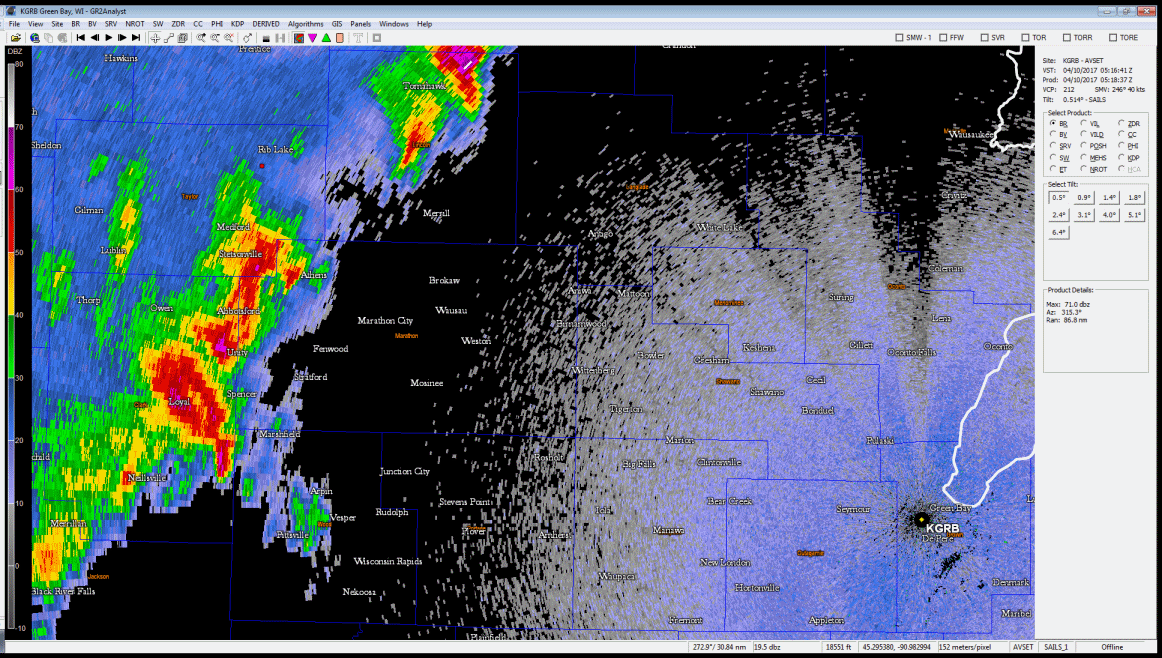
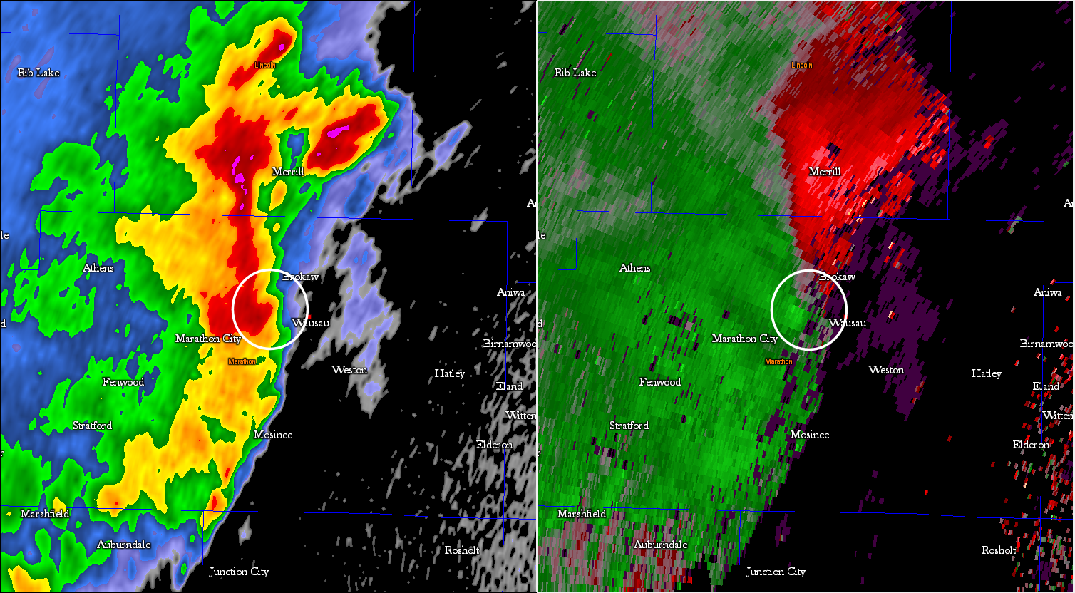
Radar Imagery
Here is some radar imagery from the event.
|
Radar animation (above) showing the more intense second round of storms between about 1245 am CDT and 3 am CDT on April 10. Note how the southern cluster of storms over central Wisconsin evolves in to a bowing line structure during this time period. |
|
|
Close-up radar animation of the tornadic storm that produced an EF1 tornado just west of Wausau around 1255 am CDT. The radar animation is from about 1245 am CDT through about 105 am CDT. |
|
|
A close-up still 2-panel image of the tornadic storm when the tornado was on the ground a few miles WNW of Wausau. The image on the left is the low-level reflectivity and the image on the right is the corresponding storm-relative velocity. The tornadic storm was about 70 nm WNW of the Green Bay Doppler Radar. The tornado was associated with a line segment that was surging eastward across the Wausau area. |
|
 |
Media use of NWS Web News Stories is encouraged! Please acknowledge the NWS as the source of any news information accessed from this site. |
|