Overview
|
Scattered severe thunderstorms moved across much of central and east-central WI during the afternoon and evening hours on August 7, 2019. Sporadic tree and power line damage was reported. WPS reported over 14,000 power outages at the peak of the event. An EF0 tornado occurred in the city of Green Bay. Straight-line winds over 70 mph were measured in Oshkosh. In addition, large hail occurred with some of the storms. The information below is preliminary and will be refined over the next week. Please see the tabs below for more information.
|
 |
Tornado:
|
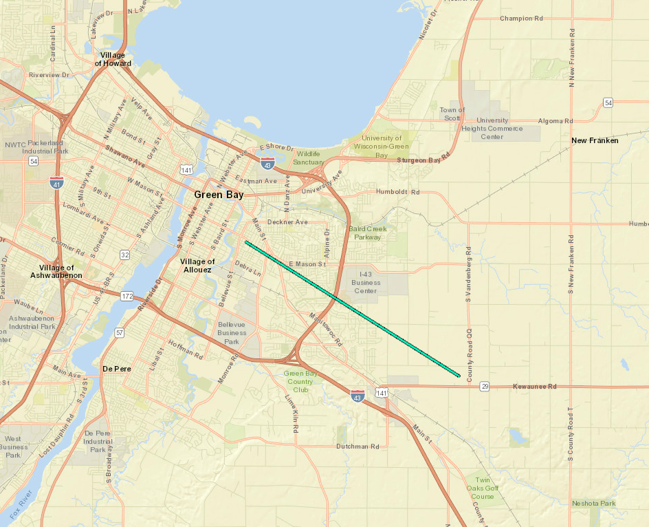
Green Bay (Preliminary findings)
Track Map
|
||||||||||||||||||||
The Enhanced Fujita (EF) Scale classifies tornadoes into the following categories:
| EF0 Weak 65-85 mph |
EF1 Moderate 86-110 mph |
EF2 Significant 111-135 mph |
EF3 Severe 136-165 mph |
EF4 Extreme 166-200 mph |
EF5 Catastrophic 200+ mph |
 |
|||||
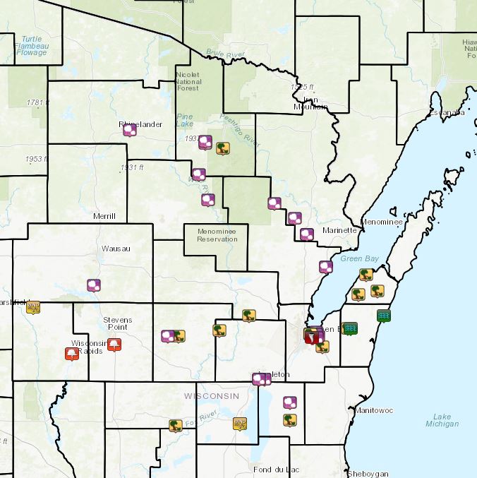
Wind and Flooding Reports:
|
|
|
| Storm reports on August 7 |
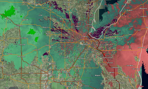
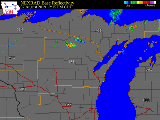
Radar:
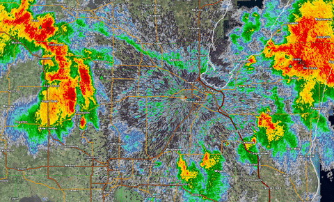 |
| Radar Reflectivity from 5:00 PM to 6:15 PM August 7, 2019 |
|
Storm Relative Radar Reflectivity from 5:00 PM to 6:15 PM August 7, 2019 |
Preliminary Storm Reports
PRELIMINARY LOCAL STORM REPORT...SUMMARY
NATIONAL WEATHER SERVICE GREEN BAY WI
941 PM CDT WED AUG 7 2019

..TIME...   ...EVENT...      ...CITY LOCATION...     ...LAT.LON...
..DATE...   ....MAG....      ..COUNTY LOCATION..ST.. ...SOURCE....
            ..REMARKS..

1238 PM     HAIL             RHINELANDER             45.63N 89.41W
08/07/2019  M0.88 INCH       ONEIDA             WI   BROADCAST MEDIA

0100 PM     HAIL             4 E CRANDON             45.56N 88.82W
08/07/2019  M0.75 INCH       FOREST             WI   PUBLIC

0119 PM     TSTM WND DMG     2 S LAONA               45.53N 88.68W
08/07/2019                   FOREST             WI   LAW ENFORCEMENT

            2 TREES DOWN 2 MILES SOUTH OF LAONA. 1 TREE DOWN 1 MILE
            NORTH OF LAONA ON DIRT ROAD ALSO.

0212 PM     HAIL             3 NE PICKEREL           45.39N 88.87W
08/07/2019  E0.25 INCH       FOREST             WI   PUBLIC

0242 PM     HAIL             13 W CRIVITZ            45.23N 88.28W
08/07/2019  E1.00 INCH       MARINETTE          WI   PUBLIC

            REPORT RECEIVED VIA TWITTER.

0332 PM     HAIL             6 NW POUND              45.15N 88.12W
08/07/2019  E1.50 INCH       MARINETTE          WI   PUBLIC

            SLIGHTLY SMALLER THAN GOLF BALL SIZE HAIL REPORTED BY
            PUBLIC ON COUNTY HWY P

0338 PM     TSTM WND DMG     COLEMAN                 45.06N 88.03W
08/07/2019                   MARINETTE          WI   FIRE DEPT/RESCUE

            POWER POLE DOWN IN COLEMAN. REPORT FROM COLEMAN FIRE
            DEPARTMENT VIA SCANNER. TIME ESTIMATED BY RADAR.

0340 PM     HAIL             COLEMAN                 45.06N 88.03W
08/07/2019  E1.75 INCH       MARINETTE          WI   PUBLIC

            ESTIMATED FROM PICTURE ON SOCIAL MEDIA

0340 PM     HAIL             COLEMAN                 45.06N 88.03W
08/07/2019  E0.88 INCH       MARINETTE          WI   LAW ENFORCEMENT

0406 PM     HAIL             OCONTO                  44.88N 87.88W
08/07/2019  M1.50 INCH       OCONTO             WI   PUBLIC

            UPDATE OF PREVIOUS REPORT - OBSERVER MEASURED HAIL AND
            FOUND SOME AS LARGE AS 1.5 INCHES

0406 PM     HAIL             OCONTO                  44.88N 87.88W
08/07/2019  E1.00 INCH       OCONTO             WI   PUBLIC

            HAIL UP TO AN INCH IN DIAMETER IN OCONTO.

0414 PM     HAIL             HOLLISTER               45.25N 88.80W
08/07/2019  E0.25 INCH       LANGLADE           WI   PUBLIC

0421 PM     TSTM WND DMG     LITTLE STURGEON         44.84N 87.57W
08/07/2019                   DOOR               WI   LAW ENFORCEMENT

            TREES DOWN. TIME ESTIMATED BY RADAR.

0435 PM     TSTM WND DMG     MAPLEWOOD               44.75N 87.48W
08/07/2019                   DOOR               WI   LAW ENFORCEMENT

            1 TREE DOWN. TIME ESTIMATED BY RADAR.

0435 PM     HAIL             IOLA                    44.50N 89.11W
08/07/2019  M0.25 INCH       WAUPACA            WI   PUBLIC

0435 PM     TSTM WND DMG     BRUSSELS                44.73N 87.63W
08/07/2019                   DOOR               WI   LAW ENFORCEMENT

            TREES DOWN. TIME ESTIMATED BY RADAR.

0442 PM     TSTM WND DMG     4 E IOLA                44.50N 89.03W
08/07/2019                   WAUPACA            WI   TRAINED SPOTTER

            ESTIMATED 45 TO 55 MPH GUST. 4 TO 5 INCH DIAMETER
            BRANCHES DOWN AND 2 TREES UPROOTED.

0442 PM     HAIL             GREEN BAY               44.51N 88.00W
08/07/2019  E0.50 INCH       BROWN              WI   PUBLIC

            DIME SIZE HAIL AT INTERSECTION OF EAST MASON STREET AND
            ALPINE ROAD.

0459 PM     TSTM WND DMG     BEAR CREEK              44.53N 88.71W
08/07/2019                   OUTAGAMIE          WI   LAW ENFORCEMENT

            COUPLE TREES DOWN IN THE TOWNSHIP OF DEER CREEK, FAR
            NORTHWEST OUTAGAMIE COUNTY.

0512 PM     TSTM WND DMG     NAVARINO                44.61N 88.48W
08/07/2019                   SHAWANO            WI   LAW ENFORCEMENT

            NUMEROUS TREES DOWN, SOME ON POWER LINES, OVER THE SOUTH
            CENTRAL AND SOUTHEAST PART OF SHAWANO COUNTY.

0550 PM     TSTM WND DMG     2 SE GREEN BAY          44.49N 87.98W
08/07/2019                   BROWN              WI   911 CALL CENTER

            ROOF OFF HARDWARE STORE AND TREES SNAPPED IN A 2-4 BLOCK
            RADIUS ON SOUTHEAST SIDE OF GREEN BAY.

0550 PM     HAIL             2 ENE GREEN BAY         44.52N 87.96W
08/07/2019  E0.75 INCH       BROWN              WI   PUBLIC

0554 PM     HAIL             GREEN BAY               44.51N 88.00W
08/07/2019  E0.50 INCH       BROWN              WI   PUBLIC

            DIME SIZE HAIL AT INTERSECTION OF EAST MASON STREET AND
            ALPINE DRIVE.

0555 PM     TSTM WND DMG     1 N BELLEVUE            44.44N 87.91W
08/07/2019                   BROWN              WI   LAW ENFORCEMENT

            WIRES DOWN BELLEVUE AND ALLOUEZ AREAS

0601 PM     HAIL             MOSINEE                 44.78N 89.69W
08/07/2019  E0.25 INCH       MARATHON           WI   TRAINED SPOTTER

            BRIEF GUSTY WINDS AS WELL. NO ESTIMATE OF SPEED.

0605 PM     FLOOD            LUXEMBURG               44.54N 87.69W
08/07/2019                   KEWAUNEE           WI   LAW ENFORCEMENT

            FLOODING REPORTED FROM LUXEMBURG TO ALGOMA. NO OTHER
            DETAILS KNOWN AT THIS TIME. TIME ESTIMATED.

0605 PM     TSTM WND DMG     1 W LUXEMBURG           44.54N 87.71W
08/07/2019                   KEWAUNEE           WI   LAW ENFORCEMENT

            COUPLE SMALL TREES AND SOME BRANCHES DOWN AT HWY 54 AND
            H. TIME ESTIMATED BY RADAR.

0620 PM     TSTM WND GST     MARSHFIELD              44.66N 90.16W
08/07/2019  M61.00 MPH       WOOD               WI   ASOS

0655 PM     FUNNEL CLOUD     PLOVER                  44.45N 89.53W
08/07/2019                   PORTAGE            WI   CO-OP OBSERVER

            2 FUNNEL CLOUDS AFTER SHELF CLOUD WENT THROUGH. PEAK WIND
            OF 41 MPH ASSOCIATED WITH THE SHELF CLOUD.

0657 PM     FUNNEL CLOUD     1 W WISCONSIN RAPIDS    44.40N 89.86W
08/07/2019                   WOOD               WI   AMATEUR RADIO

            BRIEF FUNNEL CLOUD THEN DISAPPATED

0702 PM     HAIL             2 E APPLETON            44.26N 88.36W
08/07/2019  E0.88 INCH       OUTAGAMIE          WI   TRAINED SPOTTER

0705 PM     HAIL             APPLETON                44.26N 88.40W
08/07/2019  E1.00 INCH       OUTAGAMIE          WI   PUBLIC

            FROM SOCIAL MEDIA

0705 PM     HAIL             HILBERT                 44.13N 88.16W
08/07/2019  E1.00 INCH       CALUMET            WI   PUBLIC

            FROM SOCIAL MEDIA. TIME ESTIMATED.

0709 PM     HAIL             2 E GREEN BAY           44.51N 87.96W
08/07/2019  M1.00 INCH       BROWN              WI   NWS EMPLOYEE

            MOST HAIL WAS SMALLER, BY SOME UP TO QUARTER SIZE.

0719 PM     FLOOD            GREEN BAY               44.51N 88.00W
08/07/2019                   BROWN              WI   NWS EMPLOYEE

            2 FEET OF STANDING WATER AT INTERSECTION OF MILITARY AND
            SHAWANO IN GREEN BAY

0727 PM     HAIL             APPLETON                44.26N 88.40W
08/07/2019  E1.00 INCH       OUTAGAMIE          WI   PUBLIC

0743 PM     TSTM WND DMG     3 SE REDGRANITE         44.00N 89.05W
08/07/2019                   WAUSHARA           WI   LAW ENFORCEMENT

            1 TREE DOWN IN TOWNSHIP OF WARREN

0759 PM     TSTM WND GST     OSHKOSH                 44.01N 88.55W
08/07/2019  M71.00 MPH       WINNEBAGO          WI   ASOS

            GUST TO 62 KNOTS ON OSH ASOS

0801 PM     TSTM WND DMG     OSHKOSH                 44.01N 88.55W
08/07/2019                   WINNEBAGO          WI   LAW ENFORCEMENT

            COUPLE BRANCHES DOWN ON WIRES AND A TREE DOWN AROUND THE
            OSHKOSH VICINITY

0821 PM     TSTM WND DMG     CHILTON                 44.03N 88.16W
08/07/2019                   CALUMET            WI   TRAINED SPOTTER

            LARGE TREE BRANCHES DOWN ON WATER STREET IN CHILTON.
 |
Media use of NWS Web News Stories is encouraged! Please acknowledge the NWS as the source of any news information accessed from this site. |
|


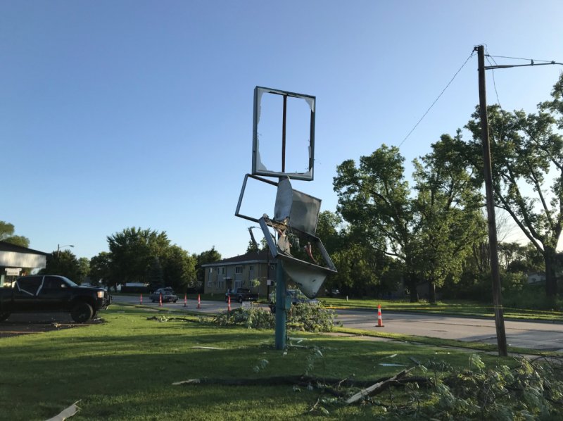 Sign and tree damage
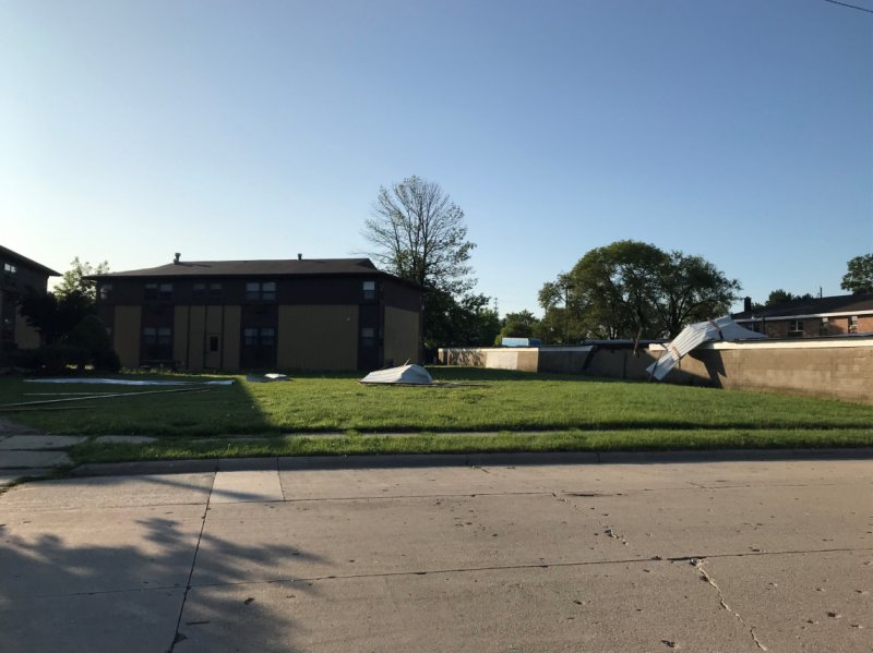 Carport damage
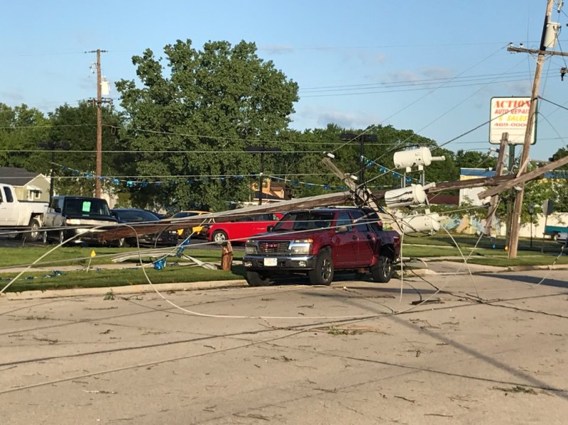 Power pole damage