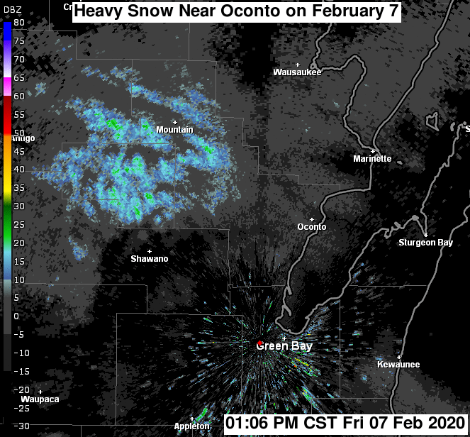
Preliminary Event Overview
A cluster of snow showers dropping southeast out of north-central Wisconsin intensified as it encountered a cold front pushing southwest through eastern Wisconsin. The result was a brief period of heavy snow from eastern Menominee County (Wisconsin) to Oconto County, across the Bay of Green Bay, to the southwest tip of Door County. Reports of up to 6 inches of snow were received from this area. The snow showers dissipated as they continued to the southeast and the front departed to the southwest.
Below is a radar loop of the event.
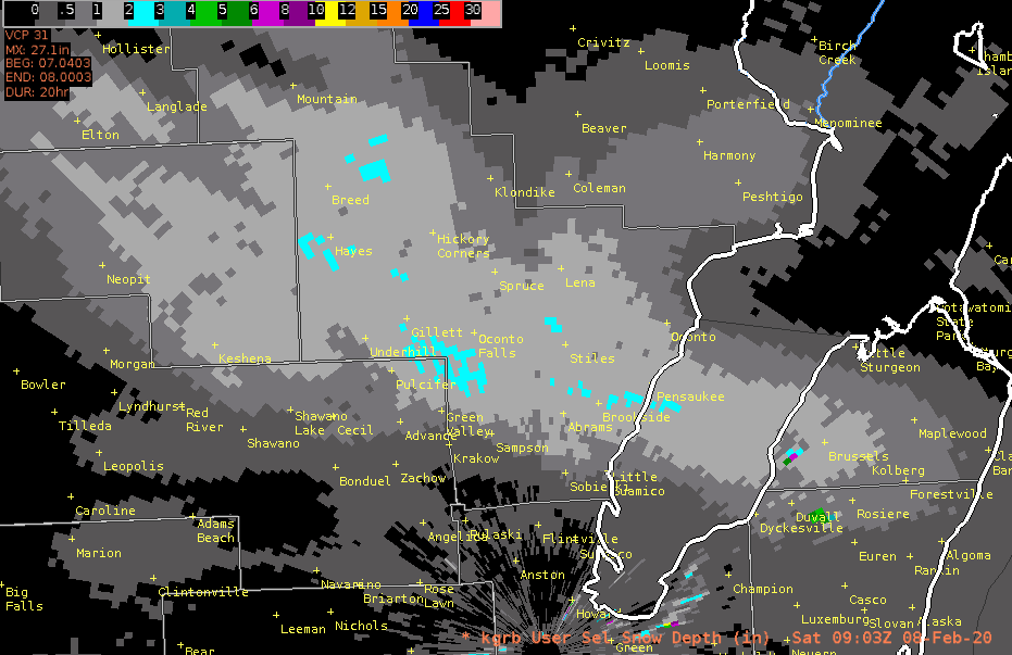
Below is an image of radar estimated snowfall from the KGRB doppler radar. It shows the area where the heaviest snow fell, but the values shown are an underestimate of actual snowfall amounts.
Below is a summary of snowfall reports received by the National Weather Service through late Friday evening.
NWUS53 KGRB 080252
LSRGRB

PRELIMINARY LOCAL STORM REPORT...SUMMARY
NATIONAL WEATHER SERVICE GREEN BAY WI
851 PM CST FRI FEB 7 2020

..TIME...   ...EVENT...      ...CITY LOCATION...     ...LAT.LON...
..DATE...   ....MAG....      ..COUNTY LOCATION..ST.. ...SOURCE....
            ..REMARKS..

0630 PM     SNOW             OCONTO FALLS            44.88N 88.20W
02/07/2020  M5.0 INCH        OCONTO             WI   TRAINED SPOTTER

            REPORT RELAYED VIA SOCIAL MEDIA.

0741 PM     SNOW             SURING                  45.00N 88.38W
02/07/2020  M5.0 INCH        OCONTO             WI   PUBLIC

            REPORT RELAYED VIA SOCIAL MEDIA.

0825 PM     HEAVY SNOW       LENA                    44.95N 88.05W
02/07/2020  M6.0 INCH        OCONTO             WI   PUBLIC

            REPORT RELAYED VIA SOCIAL MEDIA.

0825 PM     SNOW             STILES                  44.86N 88.05W
02/07/2020  M4.0 INCH        OCONTO             WI   TRAINED SPOTTER

&&

$$

