Green Bay, WI
Weather Forecast Office
Preliminary Event Overview
The second winter storm this week struck during the Thanksgiving weekend, impacting Wisconsin from late Saturday evening November 30th through Sunday December 1st. The storm developed over the Central Plains early Saturday, then quickly moved east to the Wisconsin/Illinois border on Sunday. Warm air aloft brought a mix of rain, sleet, freezing rain, and snow to the area Saturday afternoon and Saturday evening, transitioning to all snow by Saturday night and continuing into Sunday. A band of 8 to 12 inches fell across northern Wisconsin, with some areas receiving as much as 15 inches of snow. Further south snowfall totals were lower in the 4 to 8 inch range, however gusty winds caused some downed trees and power outages across the region. In addition to the wintry weather, strong winds and abnormally high lake levels caused lake shore flooding along Lake Michigan and the Bay of Green Bay, especially in Brown and Oconto Counties.
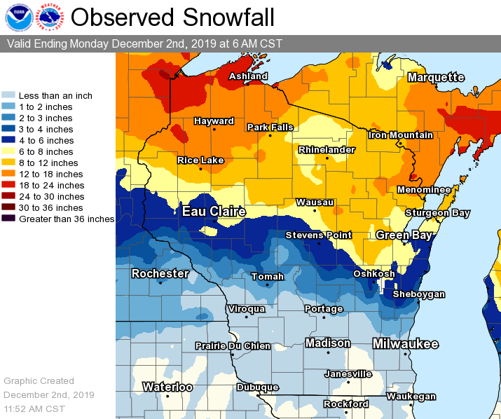
Figure 1 - Preliminary estimate of storm total snowfall.
** This overview will be updated as new information becomes available.
US Dept of Commerce
National Oceanic and Atmospheric Administration
National Weather Service
Green Bay, WI
2485 South Point Road
Green Bay, WI 54313-5522
920-494-2363
Comments? Questions? Please Contact Us.

