
Heat expands across the Desert Southwest, Plains, Mississippi Valley and Midwest into Monday. Fire weather concerns continue for portions of the Intermountain West. Active monsoonal moisture fuels thunderstorms over the Southwest with possible flash flooding. Tropical cyclone Fausto in the Pacific, should weaken as it approaches Hawaii; Dangerous surf, swells and rip currents are expected. Read More >
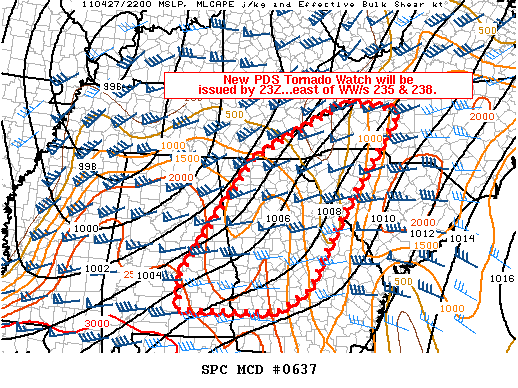
MESOSCALE DISCUSSION 0637
NWS STORM PREDICTION CENTER NORMAN OK
0541 PM CDT WED APR 27 2011

AREAS AFFECTED...PARTS OF ERN AL...NRN/CENTRAL GA...AND WRN NC/SC

CONCERNING...SEVERE POTENTIAL...TORNADO WATCH LIKELY

VALID 272241Z - 272315Z

A NEW TORNADO WATCH IS BEING COORDINATED TO THE EAST OF WW/S 235 AND
238.  THIS NEW WATCH WILL LIKELY BE A PDS WATCH.

STRENGTHENING SLY LOW LEVEL WINDS /50-60 KT/ THIS EVENING ACROSS ERN
AL INTO CENTRAL/NRN GA TO WRN PARTS OF SC/NC WILL MAINTAIN A MOIST
AIR MASS /SURFACE DEWPOINTS RISING INTO THE MID 60S/ AND SUPPORTING
MLCAPE 1000-2000 J/KG.  THIS COMBINED WITH INCREASING SWLY MIDLEVEL
WINDS ATOP THE LOW LEVEL WINDS WILL SUPPORT STRONG EFFECTIVE BULK
SHEAR /50-70 KT/ FOR DISCRETE SUPERCELLS AS ACTIVITY NOW LOCATED
OVER AL AND ERN TN DEVELOPS DOWNSTREAM.

..PETERS.. 04/27/2011


ATTN...WFO...RNK...CAE...GSP...MRX...FFC...TAE...BMX...MOB...

LAT...LON   32358642 35008451 36218196 35998051 33778216 32098310
            31598390 31608645 32358642
|


 Hourly Weather