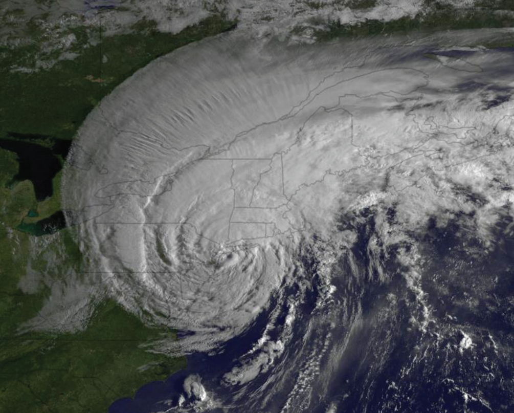
Geostationary Operational Environmental Satellite (GOES) east image of Hurricane Irene making landfall near New York City on August 28, 2011.
Overview
Hurricane Irene left a devastating imprint on portions of New England in late August 2011. Hurricane Irene made landfall across western Long Island, NY and was downgraded to a Tropical Storm as it moved into and through New England. The storm produced widespread, devastating flooding in Vermont, New Hampshire, New York, and New Jersey and damaging storm surge along the coasts of North Carolina and Connecticut. The storm did extensive damage to property and infrastructure mostly from high winds and flooding. Once the event was said and done, 44 people lost their lives from the hurricane, 1 of whom was from New Hampshire and there were 2 fatalities in Maine.
Storm Track
Irene made landfall near Cape Lookout, North Carolina on August 27 with an intensity of 75 kt, producing category 1 hurricane-force winds within a swath primarily to the east of the center over the North Carolina sounds and the Outer Banks. Irene then continued north-northeastward, just offshore of the Delmarva peninsula, and made another landfall very near Atlantic City, New Jersey, on the morning of the 28th. Although Irene’s intensity at the New Jersey landfall was 60 kt, winds of that strength were confined to the waters east of the track of the center. Irene continued moving north northeastward and the center moved over Coney Island, Brooklyn, New York. Once again, the storm’s strongest winds at the time of landfall (55 kt) continued to occur primarily well to the east of the center. Irene moved north-northeastward over New England and became extratropical when its center was near the New Hampshire/Vermont border on the evening of the 28th.
Winds
The strongest winds across the state began Sunday morning in southern areas and spread northward during the day. The strong winds continued into the evening as the center of Irene approached. Winds continued to be gusty overnight as the storm moved away from the area. Observed maximum wind gusts included 63 mph at Portsmouth, 52 mph at Concord, 51 mph at Manchester, 48 mph at Laconia, 45 mph at Berlin, 39 mph at Whitefield, and 30 mph at Lebanon. On the top of Mt. Washington, winds gusted to 104 mph as the storm approached and 120 mph as it moved away. The combination of wet soil and the prolonged period of strong and gusty winds brought down numerous trees throughout the state. One person was killed and three people were injured across the state due to falling trees or branches. In Wolfeboro, a 30 year-old man was killed and a 60-yr-old man was injured when a tree fell on them while cleaning up debris in the roadway. A man in Concord was injured when he was struck by a falling tree branch. In Bedford, a man was injured by a falling limb while cleaning up other tree limbs. Saturated soils also contributed to the large number of trees uprooted by Irene’s winds.
Rainfall
The track of Irene was greatly influenced by a strong shortwave trough over Quebec that dipped south into New England on the 28th. This trough helped steer Irene inland as it moved north, and essentially shifted the heaviest rain from the east side of the storm to the west due to increased upper level dynamics. This in combination with upslope flow (see more below) allowed for some extreme precipitation amounts in the mountains.
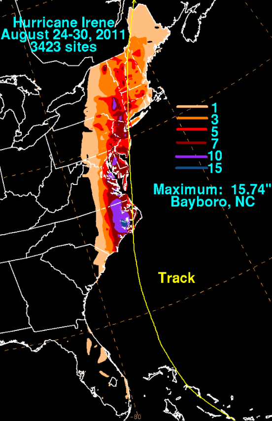
Rainfall amounts across the state ranged from 1.5 to 3 inches across southeastern New Hampshire with 3 to 6 inches across most of the remainder of the State, except in the White Mountains where 5 to 8 inches of rain fell. Rainfall was elevation dependant with the highest elevations receiving the greatest amounts. In the White Mountains, much of the rain fell within a period of only several hours causing serious flash flooding of rivers and streams across Carroll, Grafton, and Coos Counties. Many bridges and roads were washed out or damaged by the flash floods. Observed precipitation amounts included over 7 inches at Pinkham Notch, Bartlett, and Randolph, and between 6 and 7 inches at Alexandria, Gorham, Wolfeboro, and Center Sandwich. Much of the higher terrain in central and southern New Hampshire received between 4 and 6 inches of rain. The highest rainfall in our forecast area, the Mount Washington Observatory in Sargent's Purchase, NH recorded 7.35” for the event. With this much rainfall, the surrounding rivers crested to record heights.
Flooding
Irene’s main impact was from rainfall. Catastrophic floods occurred in New York and New England, especially in central and southern Vermont and New Hampshire. These rains caused devastating flash flooding across many mountain valleys with some record breaking flood stages on larger rivers.
Flooding had been common in New England starting with a wetter than normal spring, followed by a wet summer. The rainfall in August of 2011 prior to Irene was about 150% above normal for Maine and New Hampshire, setting the stage for catastrophic flooding with saturated soils and already elevated rivers and streams. Flash flooding was extensive, highest in Gorham where damage to infrastructure was estimated at 6.5 million dollars.
River Flooding at official gage forecast points.
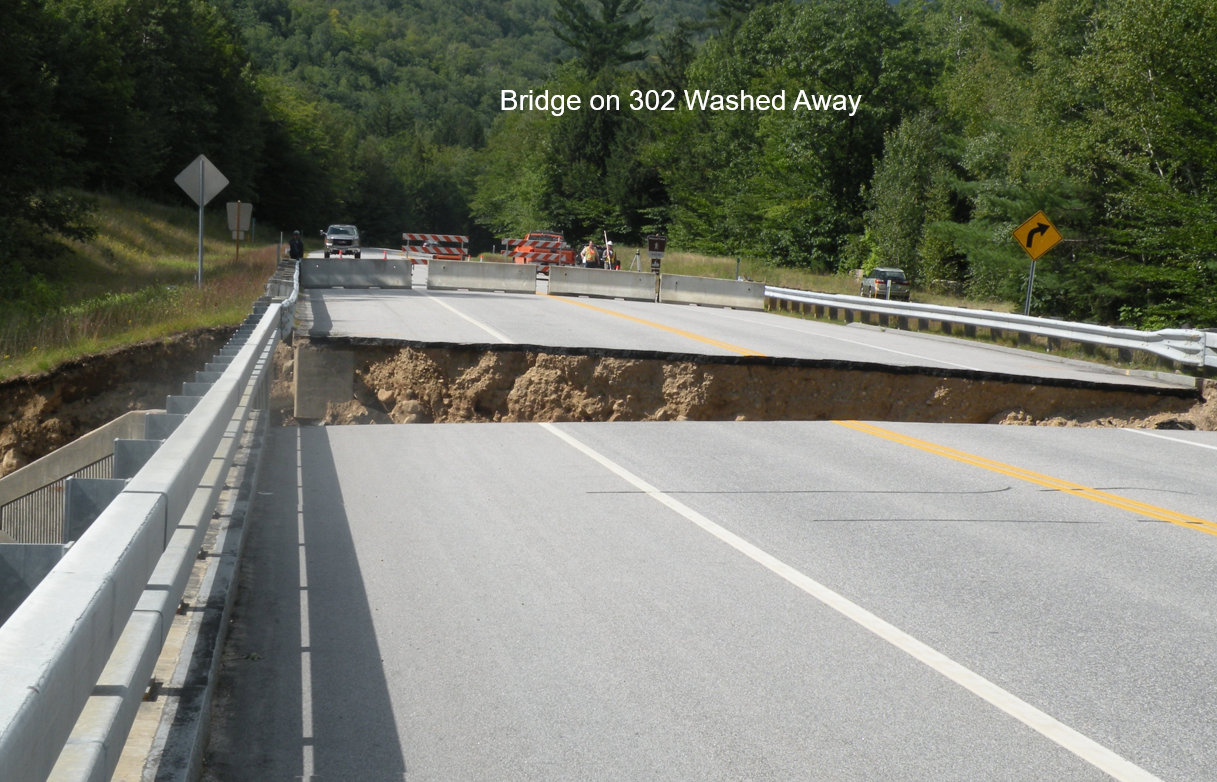
Photo 1: Washout on the Sawyer River Bridge (RT 302) in NH
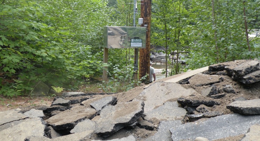
Photo 2: Saco River upstream of Bartlett NH where homes were flooded due to a breach in a levee
The hurricane brought more substantial flooding to New Hampshire, as there was a strong, moist low level onshore flow. So what does this mean? Why is this significant? This means that we had moisture feeding into the hurricane through winds aloft, which came from the Atlantic Ocean and moved west, into Maine and New Hampshire. Since the wind moves over the land, it gets orthogonally lifted. This just means that as the wind moves onshore, it has to move up with the increasing land elevation. This is important too, because the atmosphere was unstable. An unstable atmosphere just means that the air temperature gets colder the higher you move up in the atmosphere. Now, since we know that the atmosphere is unstable, let's talk about moisture! The warmer the temperature is, the more water vapor can fit into the atmosphere. So when the atmosphere cools, the atmosphere gets more moist. However, the atmosphere can not have a higher concentration than 100% relative humidity, so this extra moisture gets disposed of by precipitation/enhancing existing precipitation. This is why orthogonal lifting was a big factor in the significant New Hampshire and Maine flooding caused by hurricane Irene. Also, notice that Mount Washington, NH had the largest precipitation total. This was because the onshore wind had to get lifted over 6000 feet, which more moisture than lower elevated areas needed to be disposed of as the wind reacted to the terrain of the Presidential Range.
Other Hurricane Irene Anniversary Websites:
The Road Forward From Irene: New Hampshire's Path to an Inter-Agency Flood Risk Management Approach

