National Weather Service United States Department of Commerce


What is SKYWARN™?

The effects of hazardous weather are felt every year by many Americans. To obtain critical weather information, NOAA's National Weather Service (NWS), part of the U.S. Department of Commerce, established SKYWARN™ with partner organizations. SKYWARN™ is a volunteer program with nearly 290,000 trained severe weather spotters. These volunteers help keep their local communities safe by providing timely and accurate reports of severe weather to the NWS.

In the average year, 10,000 severe thunderstorms, 5,000 floods and more than 1,000 tornadoes occur across the United States.  In addition, crippling winter storms, high winds, ice storms and blizzards disrupt daily lives and cause substantial economic damage.  Northern New England is no exception to these threats with damaging storms occurring numerous times per year. These events threatened lives and property and because of this we rely heavily on our SKYWARN™ volunteers who call the NWS in Gray, ME to report certain weather conditions. Since the program started, the information provided by SKYWARN™ spotters, coupled with Doppler-radar technology, improved GOES Satellite and other data, has enabled NWS to issue more timely and accurate warnings for tornadoes, severe thunderstorms, flash floods and winter hazards.

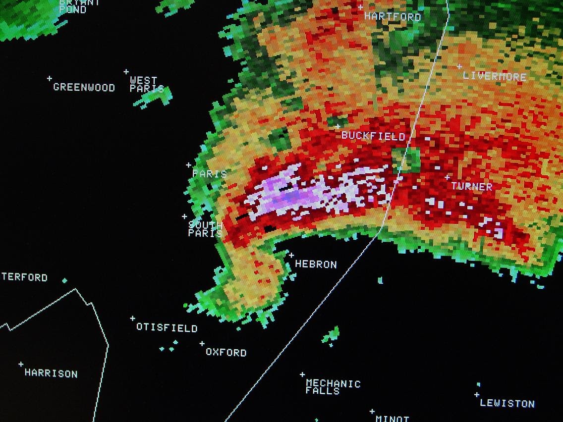
SKYWARN™ storm spotters are part of the ranks of citizens who form the Nation's first line of defense against hazardous weather. There can be no finer reward than to know that their efforts have given communities the precious gift of time--seconds and minutes that can help save lives. While the main role of a storm spotter is to be their community's first line of defense against dangerous storms, they also provide important information to NWS warning forecasters who make critical warning decisions. Storm spotters play a critical role because they can see things that radar and other technological tools cannot, and this ground truth is critical in helping the NWS perform our primary mission, to save lives and property.

Radar Supercell in Maine Skywarn


Sessions are open to anyone with an interest in becoming a spotter.  For those that are under the age of 16, an adult sponsor is required.


Currently Scheduled 2024 Training Sessions - Spring Training Schedule

County: City Date Time Location Registration
Summer Severe SKYWARN Weather Spotter
Virtual Virtual May 9th 6-7:30 PM Virtual https://attendee.gotowebinar.com/register/793432218657726037
York Alfred May 14th 6-7:30 PM 149 Jordan Springs Rd., Alfred, ME 04002 Register HERE!
           
Advanced Summer Severe SKYWARN Weather Spotter (Take after Basic Course)
Virtual Virtual May 30th 6-7:30 PM Virtual https://attendee.gotowebinar.com/register/5500777947725128794
           
                  Questions/Comments? Contact gyx.skywarn@noaa.gov or  donald.dumont@noaa.gov


Forecasters from the National Weather Service (NWS) in Gray conduct storm spotter training sessions each year to help prepare spotters for the upcoming severe weather season. These sessions are free and open to anyone who is interested in learning about hazardous weather and the role of a spotter. There are some eligibility requirements to be a spotter: You must be able to observe the weather, be 16 years or older and be able to access a phone or website send in reports or be able to report information through the Amateur Radio Network.

Our live training sessions are approximately 1.5 hours in length, and once you complete the training, you will be an official SKYWARN™ spotter and given a spotter ID. This goal of the training is to train spotters to assist local officials and the NWS with early detection of hazardous weather, and provide ground truth during severe weather events. The learning objectives of our live training sessions are:
  • Understand the how the NWS Integrated Warning System works and how the spotter fits into this system
  • Identify the ingredients needed for organized thunderstorms
  • Recognize the visual and environmental clues suggestive of severe weather
  • Distinguish between legitimate clues and non-significant features associated with severe weather
  • Report accurate winter weather observations
  • Report all hazardous weather damage to include hail, wind, flooding, coastal flooding...etc. 
  • Learn how to stay safe when storm spotting
  • Learn proper storm reporting procedures
NH Tornado Path
Some of the NWS-Gray's spotters also are amateur radio operators. This dual role can be helpful, especially during a major storm such as a hurricane, when phone and power lines are downed and amateur radio may become the primary means of communications.
 
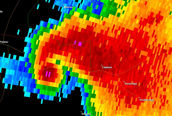
SKYWARN™ volunteers also help the NWS by reporting winter weather, flash flooding, coastal flooding, etc., according to the established criteria. It must be stressed that we are looking for reliable and objective reports. When snowfall reports are inflated or hail sizes are exaggerated, for example, it can do more harm than good. While not a requirement, it is preferred that our SKYWARN™ volunteers would be available to receive a call from the NWS, in the event we feel that something suspicious is happening in their area. A questionnaire form handed out at the training sessions allows one to give additional information, such as hours of availability, access to rivers/streams, type of weather equipment owned (if applicable), etc.

Training sessions are held throughout northern New England, typically in the late spring and early summer months. The latest training dates can be found on the Training Schedule tab just above. One can also find announcements on our website or on social media.
Relationship to COMET Training

We understand that some SKYWARN™ training courses are available through COMET (the Cooperative Program for Operations Meteorology, Education, and Training) entitled "Role of the SKYWARN™ Spotter" and "SKYWARN™ Convective Basics". While these are instructive, they do not meet the requirements to become a NWS-Gray SKYWARN™ Spotter. In order to attain a Gray SKYWARN™ ID #, it is necessary to attend one of the in-person/virtual training classes offered, usually in the spring and early summer. Once you are a trained spotter, additional recertification is suggested once every 5 years online.


Spotter reports help the NWS in the warning process. Your report becomes part of the warning decision making process, and is combined with radar data and other information and used by NWS forecasters to decide whether or not to:
  • Issue a new warning
  • Cancel an existing warning
  • Continue a warning
  • Issue a warning for the next county
  • Change the warning type (from severe thunderstorm to tornado, for example)

In addition, spotter reports are an integral part of our verification program and our national stormdata database for damaging weather events. 

For your reports to be the most useful, they should be as detailed, concise, accurate and timely as possible. Your severe weather report should address the following questions:
 
HOW TO REPORT:
  • WHAT did you see?
  • WHERE did you see it?
  • WHEN did you see it?
Report the location/approximate location of the event. Be sure to distinguish clearly between where you are and where the event is thought to be happening (i.e., "I'm 5 miles north of Concord. The tornado looks to be about 1 mile to my northwest"). Be sure that reports that are relayed through multiple sources carry the time of the event, NOT the report time.

Any other details that are important - How long did it last? Direction of travel? Was there damage? etc.
 
Phippsburg Waterspout

Although reporting criteria may vary slightly depending on the spotter network and local needs, the significant weather elements below (Severe, Hail, Wind, Winter) are ones the National Weather Service (NWS) would like to know about as soon as possible. Again, reports should provide as much detail as possible to describe the where, when, how, etc., of the event.
 
Weather Event Report Criteria What Specifically to Report
TORNADO Always Report Persistent rotation, movement direction, visible debris or damage path
FUNNEL CLOUD Always Report Persistent rotation, movement direction, placement within the storm
WALL CLOUD Wall Cloud Persistent rotation, movement direction, placement within the storm
HAIL Pea-size or larger Report the largest size hailstone
WIND GUSTS > 45 mph  Specify estimate or measurement
HEAVY RAIN Rainfall >1" per/hr How much, how quick, what you measured with
FLASH FLOODING Always Report Flooding of roads & structures, rivers outside their banks
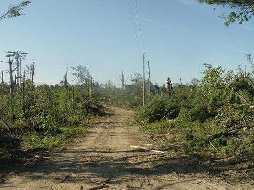
STORM DAMAGE   Damage to structures (roof, siding, windows, etc)
Damage to vehicles (from hail and/or wind)
Trees or large limbs snapped/uprooted
Power/telephone poles and/or lines down
Road damage due to flooding


Commonly used hail sizes are provided below. As a reminder, spotters are encouraged to report pea-sized hail or greater.
 
Hail Type Hail Size
Pea 0.25 inch
Half-inch 0.50 inch
Dime 0.75 inch
Nickel 0.88 inch
Quarter 1.00 inch
Half Dollar 1.25 inch
Ping Pong Ball 1.50 inch
Golf Ball 1.75 inch
Hen Egg 2.00 inch
Tennis Ball 2.50 inch
Baseball 2.75 inch
Tea Cup 3.00 inch
Grapefruit 4.00 inch
Softball 4.50 inch


General guidelines for estimating wind speeds are below. As a reminder, we encourage spotters to report wind gusts of 45 mph or greater.
 
Wind Speed Typically Observed Damage
30-44 mph (26-39 kt) Whole trees in motion. Inconvenient walking into the wind. Light-weight loose objects (e.g., lawn furniture) tossed or toppled.
45-57 mph (39-49 kt) Hardwood tree twigs and branches snap; some weakened soft trees snap or uproot. Old/weak structures (e.g., sheds, barns) may sustain minor damage (roof, doors). Buildings partially under construction may be damaged. A few loose shingles removed from houses.
58-74 mph (50-64 kt) Large limbs break of hardwood trees; shallow rooted trees pushed over.  Soft wood trees snap and uproot. Semi-trucks overturned. More significant damage to old/weak structures. Shingles, awnings removed from houses; damage to chimneys and antennas.
75-89 mph (65-77 kt) Widespread damage to trees with large limbs down or trees broken/uprooted. Mobile homes may be pushed off foundation or overturned. Roof may be partially peeled off industrial/commercial/ warehouse buildings. Some minor roof damage to homes. Weak structures (e.g., farm buildings, airplane hangars) may be severely damaged.
90+ mph (78+ kt) Widespread areas of uprooted and snapped trees. Mobile homes damaged. Roofs partially peeled off homes and buildings. Moving automobiles pushed off the road. Barns, sheds demolished.


Observations are not limited to summer storms only. The NWS is especially interested in reports when snow is falling and radar echoes are not always able to detect the amount of snowfall and conditions on the ground. Precipitation types and ice accretion are also very important. Please pass on the following information to your weather service office:
 
Weather Event Criteria
Winter Weather
  • Precipitation type changes (rain to sleet/freezing rain/snow, when the change has "taken hold")
  • Thunder, when accompanied by snow
  • Blizzard Conditions - White out conditions due to snow and blowing snow (associated with a Nor'easter or Snowsquall)
Coastal Flooding
  • Inundation of coastal areas and an estimate of the water depth
  • Water in buildings or roads closed
  • Coastal damage caused by pounding surf
  • Significant coastal dune or small rock erosion 
River Flooding
  • Any ice jams
  • River flooding of roads and/or buildings
  • First time local river ices over
Snowfall
  • Snowfall amounts 1" or greater (measure to the nearest tenth of an inch)
  • If snowfall rates are 2" per hour or greater
  • Storm total snowfall immediately after the storm ends
Freezing Rain
  • Any amount of ice accretion, measure to the nearest hundredth (.01")
  • Ice accretion >.25" send a picture
  • Vertical Thickness - Direct Measurement off ice accretion on a flat surface
  • Mean Radial Thickness - Measurement of ice on a branch/wire, measure ice thickness on both sides of object
Sleet
  • Any amount of sleet accumulation (measure to the nearest tenth of an inch)
  • If snow and sleet mixed, report the total accumulation as such


What is my spotter ID number? Do I get an ID card?ExpandCollapse

NWS Gray does issue Spotter ID numbers that will be supplied to you via a spotter training completion certificate.  The spotter training certificate will be emailed to you after you have completed the spotter training course.  The NWS Gray offices provides three courses for their weather spotter program.  We offer a Basic and Advanced spring/summer track that covers severe thunderstorms and tropical threats if requested.  We also offer a unique winter track in the fall that covers winter weather hazards.  We offer training certificated to our spotters for each individual track and we encourage our spotters to take all these training courses.  

How do I become a member of SKYWARN™?ExpandCollapse

SKYWARN™ is not to be considered a club which requires membership. It is the concept of using volunteer storm spotters to provide critical information to local communities and to the NWS, and that is what has driven the storm spotter program since it began decades ago. Your community may have an organized storm spotter network that uses the name SKYWARN™, and you should contact your local emergency manager to find out what formal spotter networks are in place near you.

Do I need an amateur radio license to be a storm spotter?ExpandCollapse

No you do not. You do not have to be an amateur radio operator to make a weather report, but many spotter networks are made up of dedicated amateur radio operators who use radio to coordinate their local network and to relay reports to the NWS.

How do I report severe weather?ExpandCollapse

Feel free to give us a call on the 1-800 number listed on your spotter ID certificate, or you can also give us your report through our online reporting form. If you by chance take any pictures of hazardous weather across northern New England, you can post that information on our social media accounts or email our Skywarn email account.

How long are the classes and are they free?ExpandCollapse

The SKYWARN™ classes generally run about 1.5 hours long. They are free and open to the public. Registration may be required at some of the training site but that will be noted on the training calendar. 

Is there a minimum age requirement to become a spotter?ExpandCollapse

Because of the complexity of severe thunderstorm structure and development, and the potential danger involved, spotting is recommended for adults. High School and Junior High School or Middle School students are welcome to attend the class with a parent or other adult. Spotter numbers are given to anyone who attends a training and is at least 16 years of age or older. People younger than 16 who desire a spotter number, and who can present special circumstances will be evaluated on a case-by-case basis along with a parent/guardian. 

If I have additional questions, who do I contact?ExpandCollapse

Please feel free to contact Donald Dumont


Below are few resources hosted locally at the National Weather Service in Gray, ME, as well as National and Amateur Radio resources concerning SKYWARN™.

General Address and Phone Number

National Weather Service

PO Box 1208

1 Weather Lane

Gray, ME 04103

(207)-688-3216


Local Amateur Radio SKYWARN Team

For more information on the local NWS Gray SKYWARN Amateur Radio Team including how to join please click here.


Additional Resources

SKYWARN Fact Sheet Storm Reports in the Past 24 Hours
SKYWARN Refresher Training Online Spotter Prep Course
National SKYWARN™ Page  
Weather Spotters Field Guide  
Online Weather Spotters Field Guide   
CoCoRaHS and WxWatcher Newsletters  


Spotter Observer Guides

Winter Weather Observing Quick Guide Coastal Flooding Observer Quick Guide