Effective Tuesday March 22nd, 2022 at 4 PM EDT, the National Weather Service Forecast Office in Gray, ME (GYX) will change the New Hampshire fire weather zones within our County Warning Area. Instead of having 15 individual fire zones, we have worked closely with our federal and state fire weather partners to reduce the amount of fire weather zones down to 6 in the state. The zone split locations have been decided based on a number of factors to include topography, fuels and local climate/weather conditions. Below are graphics depicting the changes to the fire weather zones.
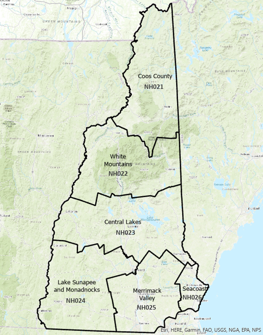
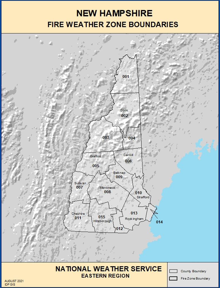
New Fire Weather Zone Numbers and Names Old Fire Weather Zone Numbers and Names
Recently there has been a significant rework of the nationwide system for predicting wildfire danger (NFDRS 2016). The NFDRS 2016 system has tasked state fire and land management agencies with reassessing and editing Fire Danger Rating Areas (FDRAs), which are geographic zones consisting of similar fuels, topography, and weather conditions. Our current fire weather zones borders are tied more to county boundaries and do not necessarily consider these important elements of fuels and topography that the new FRDAs are based on. Thus aligning our fire weather zones with the new FDRAs will better connect fire danger outputs with our suite of fire weather products (Fire Weather Planning Forecast, Fire Weather Watches, and Red Flag Warnings) to support the needs of our fire weather partners and the public.
Representatives from the New Hampshire Division of Forests & Lands have provided us with the new FDRAs and we are in full support of the geographic areas they created. Matching our fire weather zones for program alignment have been coordinated and supported by agencies associated with the fire weather program (White Mountain National Forest and New Hampshire Homeland Security and Emergency Management).
| Current Fire Weather Zone / UGC | New Fire Weather Zone / UGC |
|---|---|
| Northern Coos / NHZ001 | Coos County / NHZ021 |
| Southern Coos / NHZ002 | White Mountains / NHZ022 |
| Northern Grafton / NHZ003 | Central Lakes / NHZ023 |
| Northern Carroll / NHZ004 | Lake Sunapee & Monadnocks / NHZ024 |
| Southern Grafton / NHZ005 | Merrimack Valley / NHZ025 |
| Southern Carroll / NHZ006 | Seacoast / NHZ026 |
| Sullivan / NHZ007 | |
| Merrimack / NHZ008 | |
| Belknap / NHZ009 | |
| Strafford / NHZ010 | |
| Cheshire / NHZ011 | |
| Eastern Hillsborough / NHZ012 | |
| Interior Rockingham / NHZ013 | |
| Coastal Rockingham / NHZ014 | |
| Western & Central Hillsborough / NHZ015 |
| Product Name | WMO Header | AWIPS ID |
|---|---|---|
| Fire Weather Planning Forecast | FNUS51 KGYX | FWFGYX |
| Fire Weather Watch/Red Flag Warning | WWUS81 KGYX | RFWGYX |
| Special Weather Statement | WWUS81 KGYX | SPSGYX |
If you are affected by these changes, take the appropriate actions by March 22th, 2022 so your system(s) recognize the new zone Universal Geographic Codes (UGC) and the new zone alignments.
| Donald Dumont | Melissa Dispigna |
|---|---|
| Warning Coordination Meteorologist | Regional Aviation/Fire/Severe Program Manager |
| National Weather Service Gray, ME | National Weather Service Eastern Regional Headquarters |
| 1 Weather Lane | 630 Johnson Avenue Suite 202 |
| Gray, ME | Bohemia, NY |
| 207-688-3216 x223 | 607-972-9649 |
| Donald.Dumont@noaa.gov | Melissa.Dispigna@noaa.gov |

