
Hurricane Erin continues to track westward with its outer bands bringing heavy rainfall and gusty winds for Puerto Rico and US Virgin Islands. Life-threatening surf and rip currents are occurring and will spread across the Atlantic coasts this week. Meanwhile, heavy rainfall and possible flooding are in the forecast for upper Midwest through Monday. Heatrisk continues for the Mississippi Valley. Read More >
 |
|
|
||
|
||
|
Main Severe Weather Impacts in the Huntsville Forecast Area in 2017
|
||
Severe Weather Summary: |
||
|
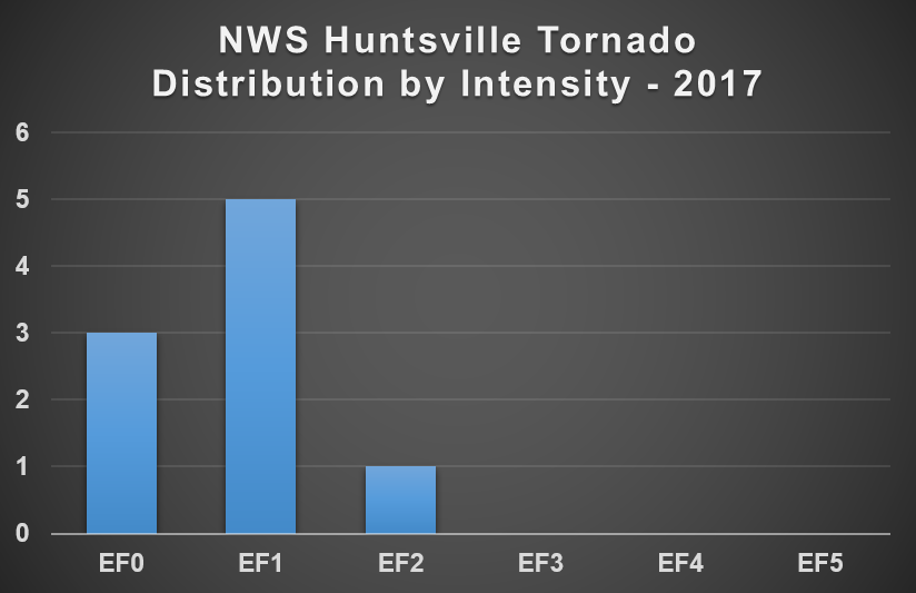
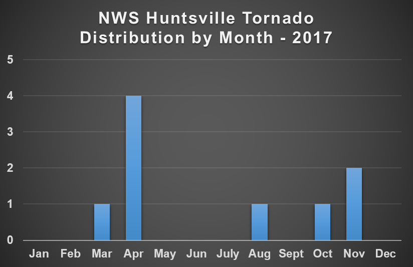
The first two months of 2017 were relatively quiet in terms of severe weather across the TN Valley, with only a few thunderstorms impacting isolated locations across the area. However that quickly changed as March arrived and the area saw multiple days with severe weather through the end of May. Although most of the severe weather that occurred during the spring severe weather season was from damaging straight line winds and hail, there were a few weak tornadoes that were observed; one on March 9th, three on April 22nd and one on April 30th. Overall, the spring severe weather season was a little quieter than what the TN Valley normally observes, but there were still 10 days that saw impacts from damaging straight line winds, hail and/or tornadoes. The summer saw several rounds of organized thunderstorms from June through August. Although not completely abnormal, the TN Valley typically experiences damaging winds and hail from unorganized "pop-up" thunderstorms. The first event occur on June 15th, when a line of storms moved through the area and produced damaging straight line winds across much of the area. Several days later, on June 23rd, the remnants of Tropical Storm Cindy moved through the region leading to thunderstorm development which produced damaging winds and flooding. The first week of July was unsettled, as several disturbances traversed the TN Valley and produced scattered thunderstorms that resulted in damaging winds knocking trees and power lines over. The remainder of July was quieter, with no notable impacts from severe thunderstorms. The quiet pattern continued through the end of August, with only a few isolated strong storms reported during the month. However, on August 31st, the remnants of Hurricane Harvey moved through the Lower Mississippi Valley and placed the TN Valley within the prime location for tornado development. Several thunderstorms moved across the area that day, with one producing an EF2 tornado in Cullman and Marshall counties. Not only is a significant tornado rare in August, it is also rare for a tropical system to produce a significant tornado. Fall, the TN Valley's secondary severe weather season, was fairly quiet as the region fell into a drier weather pattern. There were isolated thunderstorms that impacted the area in September, causing a few trees to be knocked down in the southeast portion of the forecast area. In October, there was only one day of observed severe weather, as a line of showers moved through early on the 22nd. Although no lightning was observed, there was enough low level wind shear to produce an EF1 tornado in Morgan county. November was similar, with only one day of severe weather observed. This occurred on the 18th, when a line of storms moved through a produced two EF1 tornadoes; one in Colbert county and one in Lawrence county. To learn more about the more notable events that occurred in 2017, click the links below. |
|
Severe Weather Events in 2017: |
**Note: All of the following data should be considered preliminary. Not all of the data has been |


 Local Radar
 Weather Map