
Widespread life-threatening flash and urban flooding will continue to pose a significant threat to life and property in south-central Texas. Catastrophic fiver flooding, with rapid rises on small streams, arroyos, and typically dry washes, is expected. Monsoonal showers persist across the Great Basin and Southwest with greatest flash flooding in southern Arizona. Read More >
| Rating | EF-1 | Peak Wind | 90 mph |
| Path Length | 14.6 miles | Peak Path Width | 75 yards |
| Beginning Point | 34.6655, -86.9172 | End Point | 34.7797, -86.7006 |
| Start Time | 4:53 PM | End Time | 5:07 PM |
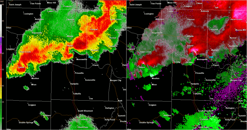
The tornado began near Interstate 65 between mile markers 342 and 343, producing EF-0 intensity winds of up to 70 mph, snapping trees. The tornado tracked northeast, producing generally minor and sporadic damage in rural Limestone County along Brownsferry Road and into the city of Madison. As the tornado moved into Madison it intensified, uprooting large trees and producing some minor damage to homes in several locations. The most notable damage occurred in Madison along Balch Road near Kentucky Drive, Wall Triana at Gooch Lane, along McCrary Road, and further northeast along Capshaw Road between Nance Road and Jeff Road. From McCrary Road to Jeff Road, the width of tornado damage increased to approximately 75 yards. The tornado then continued moving northeast across Bishop Creek Road to Holbrook Drive. Damage along this portion of the track included uprooted large trees, some snapped-off tree tops, and minor roof damage. The tornado finally lifted further northeast on Holbrook Drive.
| Hytop, AL Radar (HTX) radar loop of the EF-1 tornado track from 4:53 - 5:07 pm CDT. The imagery on the left is reflectivity, while the imagery on the right is storm-relative velocity. Click on the image to loop. |
 |


 Local Radar
 Weather Map