HOME
FORECAST
Local
Graphical
Aviation
Marine
Rivers and Lakes
Hurricanes
Severe Weather
Fire Weather
Sunrise/Sunset
Long Range Forecasts
Climate Prediction
Space Weather
PAST WEATHER
Past Weather
Astronomical Data
Certified Weather Data
SAFETY
INFORMATION
Wireless Emergency Alerts
Weather-Ready Nation
Brochures
Cooperative Observers
Daily Briefing
Damage/Fatality/Injury Statistics
Forecast Models
GIS Data Portal
NOAA Weather Radio
Publications
SKYWARN Storm Spotters
StormReady
TsunamiReady
Service Change Notices
EDUCATION
NEWS
SEARCH
Search For
NWS
All NOAA
ABOUT
About NWS
Organization
For NWS Employees
National Centers
Careers
Contact Us
Glossary
Social Media
NWS Transformation
Local forecast by
"City, St" or ZIP code
Sorry, the location you searched for was not found. Please try another search.
Multiple locations were found. Please select one of the following:
Location Help
News Headlines
June 7th 2025 Storm Reports
Storm Survey Summary for May 2025 Tornadoes
Customize Your
Weather.gov
Enter Your City, ST or ZIP Code
Remember Me
LOADING...
Huntsville, AL
Weather Forecast Office
December 24th-26th Flash Flooding and Major River Flooding
Weather.gov
>
Huntsville, AL
> December 24th-26th Flash Flooding and Major River Flooding
Current Hazards
Graphical Hazardous Weather Outlook
Submit a Storm Report
Outlooks
Current Conditions
Satellite
Surface Observations
Observed Precipitation
Local Satellite
Radar
Local Enhanced Radar
Local Standard Radar (low bandwidth)
Regional/National Standard Radar (low bandwidth)
Forecasts
Fire
Probabilistic Precipitation
Hourly View
Forecaster's Discussion
Aviation
Tropical
Local Graphical Forecast
Air Quality
Rivers and Lakes
*New* National Water Prediction Service (NWPS)
*New* NWPS - Local View
Latest River Forecast Information
Climate and Past Weather
Climate Prediction
Drought
Other Local Climate Information
Huntsville Normals and Extremes
Muscle Shoals Normals and Extremes
Historical Weather Events
Local Programs
Activity Planner Tool
Recent Storm Reports
Volunteer Observing Programs
Safety Information
Contact Us
StormReady Program
Office Research
Area Tornado History
A Tribute to H.D. Bagley
Storm Reports Database
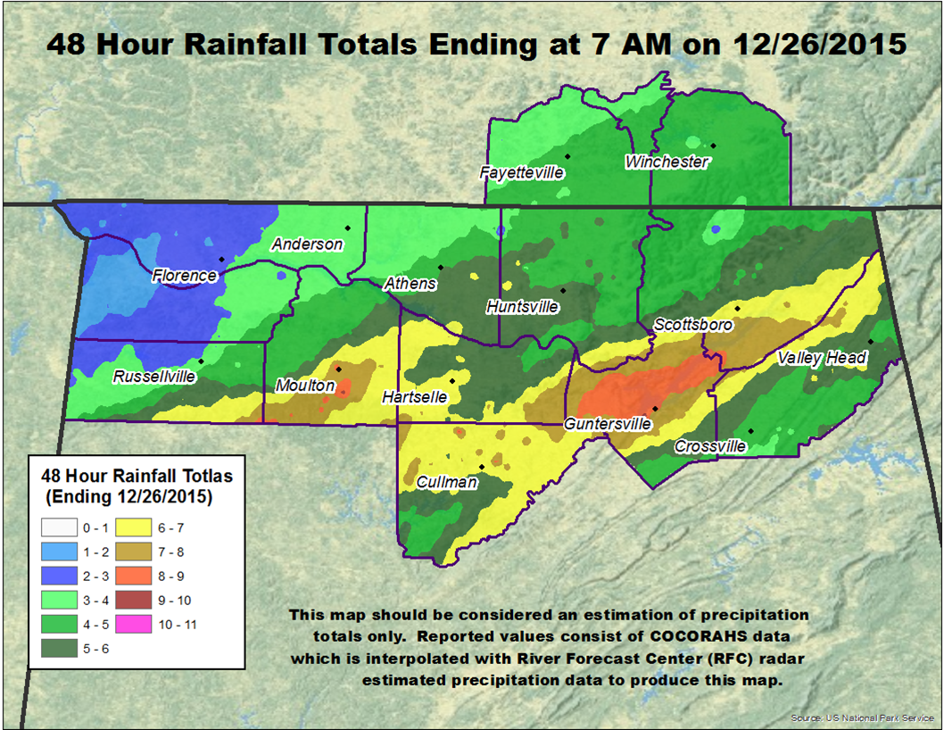
3-9 Inches of Rainfall fell December 24th - 26th
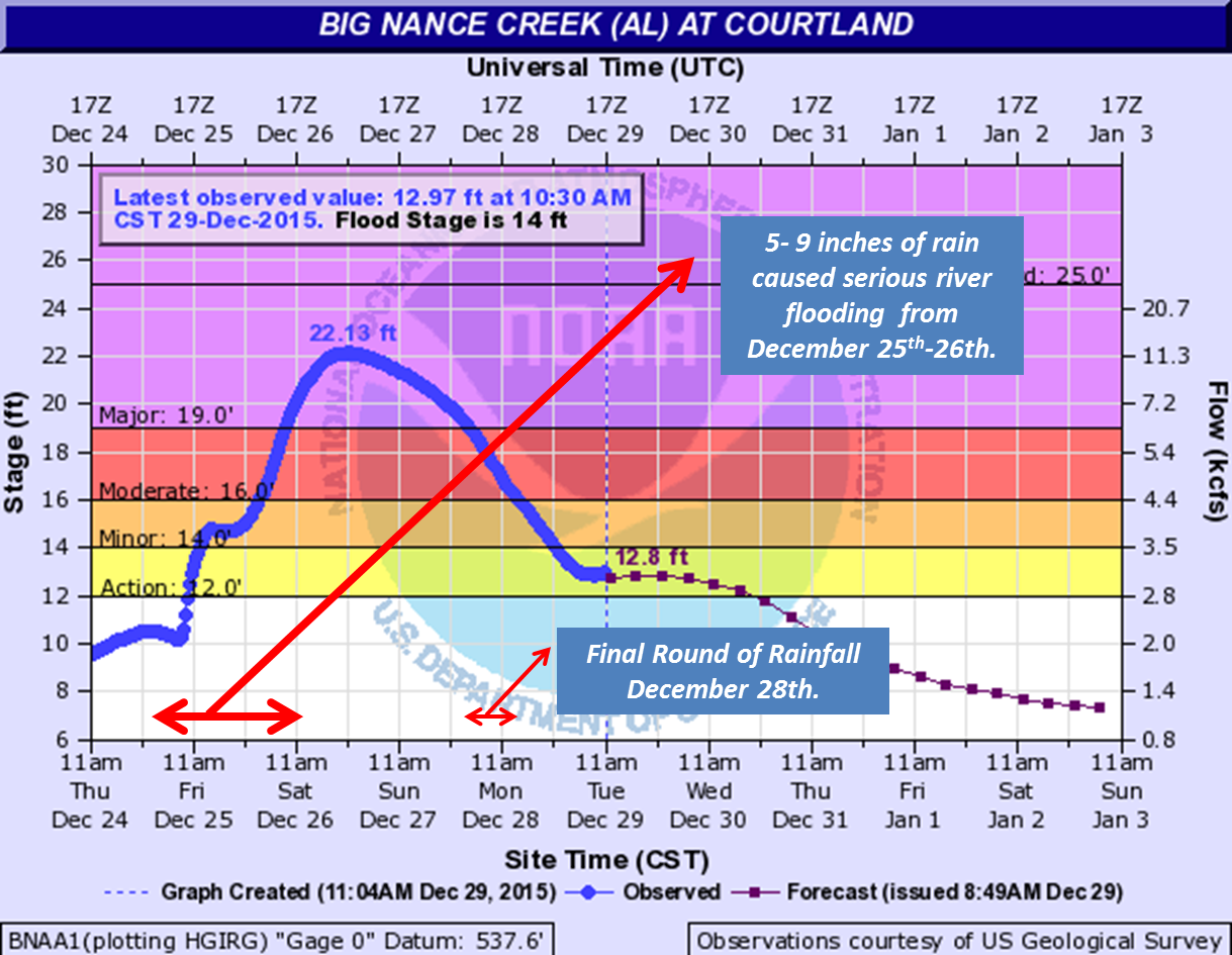
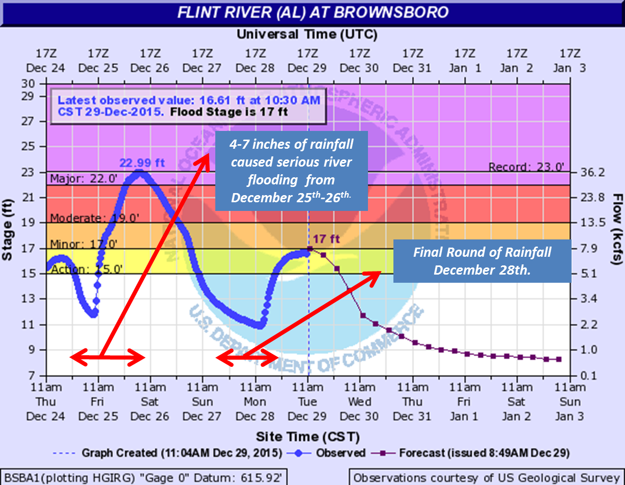
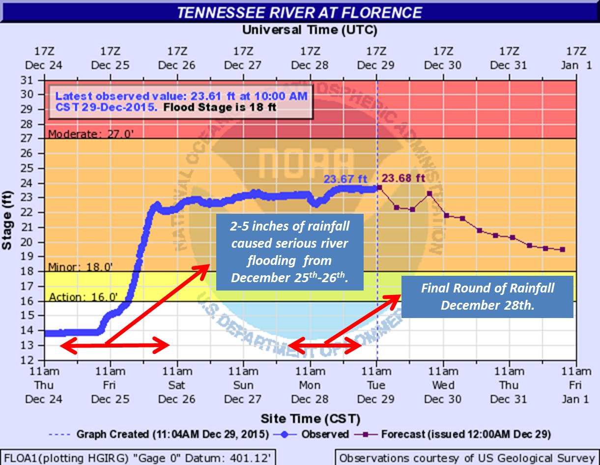
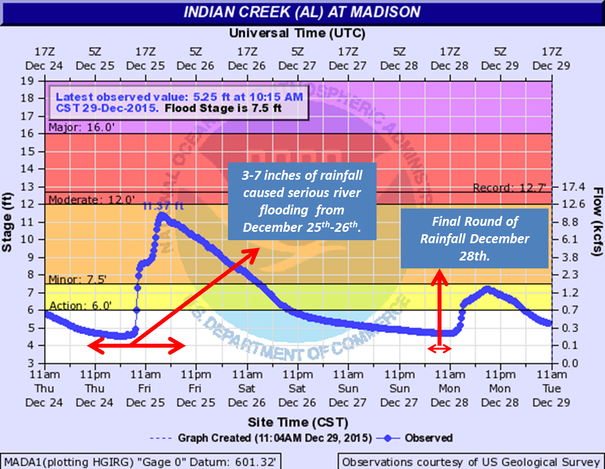
Heavy Rainfall that fell between December 25th and 26th setup major river flooding across the Huntsville forecast area.
River Flooding along the Big Nance Creek
at Courtland (Crested at 22.13 feet on the 26th - Major Flood)
River Flooding along the Flint River at
Brownsboro (Crested at 22.99 feet on the 26th,
Just shy of the record flood of 23.0 feet)
River Flooding along the Tennessee River
at Florence (Has been fluctuating between
22 and 24 feet since the 25th)
River Flooding along Indian Creek at
Madison (Crested at 11.37 feet on the 25th)
River Flooding along the Tennessee River at Whitesburg (Crested at 22.31 feeton the 27th)
Back to the Main Page
Local Radar
Weather Map
NWS Huntsville SitRep
Follow us on X
Follow us on Facebook
Follow us on YouTube
HUN RSS Feed