| Most of the abbreviations in this product are designed to be self-explanatory (i.e., Lrg Hail means large hail, or hail above 3/4" in diameter). A table of abbreviations and their specific meanings follows. |
| None |
No hazardous weather is expected across the area. |
| Lrg Hail
|
Hail greater than or equal to 3/4" in diameter. |
| Sml Hail |
Hail less than 3/4" in diameter. |
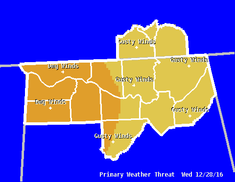
| Dmg Winds |
Wind gusts in excess of 50 kts, or 58 mph. |
| Gusty Winds |
Wind gusts 35-55 mph. |
| Lrg Hail/Dmg Winds |
Wind gusts higher than 58 mph and hail larger than 3/4" in diameter.
|
| Isold Tor |
Isolated tornadoes. |
| Lcl Flooding |
Rainfall may be heavy enough to produce localized flooding. |
| Fqt Lightning |
Storms will be capable of producing frequent cloud-to-ground lightning. |
| Lcly Heavy Rain |
Locally heavy rain is possible, but not enough to produce any flooding. |
| Dense Fog |
Fog will reduce visibilities below 1/4 mile.
|
| Heat Indices |
The heat index is forecast to reach 105ºF or higher. |
| Excessive Heat |
Prolonged heat indices of 110ºF or higher are expected.
|
| Wind Chills |
Wind chills below 10ºF are expected. |
| Extreme Cold |
Wind chills below -10ºF are expected. |
| Lt Snow |
Snow accumulations below 1/2". |
| Mdt Snow |
Snow accumulations 1/2-2". |
| Hvy Snow |
More than 2" snow in 12 hours, or more than 4" snow in 24 hours. |
| Snow/Ice |
Accumulating mix of snow and ice expected. |
| Sleet |
Sleet/ice pellets are expected to accumulate. |
| Wintery Mix |
Mix of precipitation anticipated. |
| Frzg Rain |
Ice accumulations below 0.25" are expected. |
| Frzg Drizzle |
A light coating of ice is expected. |
| Ice Storm |
Significant accumulations (more than 0.25") of ice are expected. |
| Freeze |
Temperatures are forecast to be at or below 32ºF for 3+ hours during a climatologically significant time of year. |
| Hard Freeze |
Temperatures are forecast to be at or below 28ºF for 3+ hours during a climatologically significant time of year. |
| Frost |
Frost is expected to form on vegetation and exposed surfaces. Tender vegetation may be damaged or killed. |
| Fire Risk |
Weather conditions are becoming more conducive to wildfires or rapid fire growth.
Cool Season Criteria (Nov 1st - April 30th): The relative humidity is less than or equal to 25% for four or more consecutive hours, or relative humidity less than 25% concurrent with sustained 20ft winds of 20 mph or more.
Warm Season Criteria (May 1st - October 31st): The relative humidity is less than 30%, concurrent with sustained surface winds equal to or greater than 10 mph, and Keetch-Byram Drought Index (KBDI) greater than 500. The KBDI criteria requirement is suspended if a county is under a Fire Alert.
|
|


 Local Radar
 Weather Map