
Travel conditions will be challenging across the northern Plains, Great Lakes and east coast through Thanksgiving holiday weekend. Heavy snow, blizzard conditions, for the upper Midwest and Great Lakes region through Thanksgiving to be followed by another strong storm for the Plains, Great Lakes and Northeast this weekend. Strong winds are expected with these systems adding to travel difficulties Read More >
Huntsville, AL
Weather Forecast Office
1984 - Past Significant Storm Surveys in WFO Huntsville's County Warning Area (CWA) |
||
|---|---|---|
| Primary Areas Affected (Click on map for more information) |
Date of Event | Type of Event |
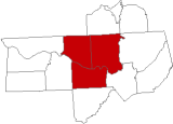 |
July 7, 1984 |
Damaging Wind |
US Dept of Commerce
National Oceanic and Atmospheric Administration
National Weather Service
Huntsville, AL
320A Sparkman Drive
Huntsville, AL 35805
256-890-8503
Comments? Questions? Please Contact Us.


 Local Radar
 Weather Map