|
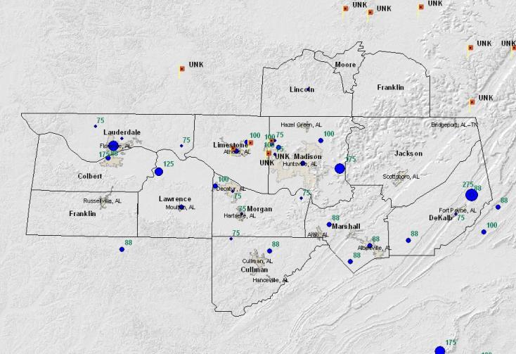
Map showing the various reports of hail and wind damage on February 21st (red squares indicated wind damage, while blue circles indicate large hail). The largest hail of the day was reported in Valley Head, DeKalb County, where an NWS Cooperative Observer reported nearly baseball size hail.
|
|
Storm Summary
February 21, 2005 was a remarkable day for the Tennessee Valley. A slow-moving cold front provided the catalyst for an extraordinary day for hailstorms in the area. The storms came in waves: the first warnings were issued around 5am, with another, stronger wave coming between 9:30 and 10:30am. The final, longest-lasting, strongest wave lasted almost 8 hours, with the first warning being issued at 12:46pm, and the last warning expiring at 8:30pm.
All told, there were more than 65 hail reports sent to the National Weather Service. Around 50 of those reports indicated dime-sized (just under 3/4") or larger hail, and 18 reported indicated hail at least the size of quarters. There were several reports of wind damage and flash flooding, with many roads in Lauderdale County closed due to high waters.
No storm surveys were conducted for this event, so we've chosen to highlight some of the largest hailstones and photographs we could find.
|
|
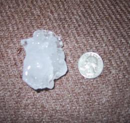
NWS Cooperative Observer Tom Crow received nearly baseball-sized hail from the strongest storm of the day, which passed through northern DeKalb County. (Thanks to WHNT-TV for relaying this picture.)
|
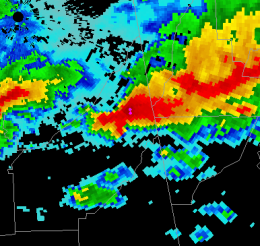
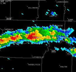
The storm responsible for the hail in DeKalb County was a supercell (note the hook echo right in the middle of the image). Despite being a supercell, the environment was not quite favorable enough for tornadoes across northern Alabama, and hail was the only damage from the storm.
|
|
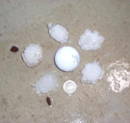
Some of the largest hail of the day fell in downtown Florence around 4:20pm, when golf-ball sized hail was reported.
|
The radar imagery from the Florence storm was much less impressive at the lowest levels. However, hail was indicated by strong echoes aloft.
|


 Local Radar
 Weather Map