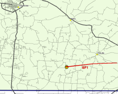
Representatives from the National Weather Service  completed a preliminary survey of damage in the Flintville, Tennessee area. The damage occurred with a supercell thunderstorm that intensified across southeastern Lincoln county between 5:30 and 5:35 PM. The storms occurred ahead of a strong cold front which pushed into southern middle Tennessee around 7 PM on the 14th. completed a preliminary survey of damage in the Flintville, Tennessee area. The damage occurred with a supercell thunderstorm that intensified across southeastern Lincoln county between 5:30 and 5:35 PM. The storms occurred ahead of a strong cold front which pushed into southern middle Tennessee around 7 PM on the 14th.
The tornado path began approximately 3.5 miles west southwest of Flintville and continued east northeast to approximately 2.4 miles southeast of Flintville. The tornado initially had a path width of 75 yards, a path length around 5.3 miles, and maximum wind speeds of 90 mph. This falls under EF-1 tornado damage on the Enhanced Fujita scale.
One mile south southwest of the Flintville area, a storage shed was destroyed and a pole barn suffered considerable damage. Also, a large oak tree at least 50 years old was uprooted just northeast of the pole barn. In other locations along the path, EF-0 damage was evident, with trees blown down and tops of trees snapped off.
|