National Weather Service United States Department of Commerce

Coastal Threats for the East and Gulf; Record Warmth for the Central U.S.

Persistent onshore flow across the Southeast and portions of the mid-Atlantic will keep the risk of rip currents through the weekend. Rainfall could be locally heavy across Florida, especially along the eastern shoreline. Meanwhile, record warmth for portions of the Plains and Midwest with elevated fire concerns. For the west, a trough will keep the pattern unsettled with wet conditions. Read More >

Preliminary Storm Survey Information
 
Storm surveys have been completed examining storm damage that occurred in the early morning hours on Wednesday, December 10th.  Information found in these surveys is described below. All tornado ratings are using the Enhanced Fujita Scale.

Central Jackson County
Rating EF-2 Peak Wind 125 mph
Path Length 3.7 miles Peak Path Width 300 yards
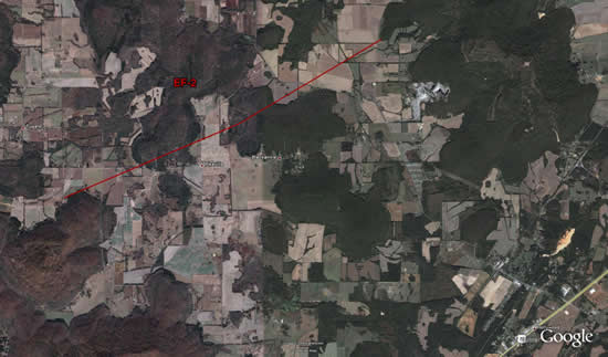
Survey Map

A squall line produced hail and thunderstorm wind damage across portions of the Tennessee Valley in addition to a tornado that tracked across central Jackson County near Pikeville, Alabama. The tornado initially snapped several cedar trees near county road 21 before toppling three high voltage power line towers. It then rapidly proceeded northeast, snapping trees, collapsing several barns, and ripping off roofs before lifting near the end of county road 34.

The tornado damage path was approximately 3.7 miles in length, and approximately 300 yards in width. Maximum wind speeds were approximately 125 mph, rating this tornado as an EF-2 on the enhanced Fujita scale.

The storm survey was completed by National Weather Service Huntsville Meteorologists David Nadler, Stephen Latimer, and Andrew Pritchett along with Victor Manning of Jackson County EMA.


Snapped Cedar Tree near Pikeville Snapped Oak Tree near Pikeville Collapsed Barn near Pikeville Collapsed Power Line Tower