
A heat wave over the Southwest will intensify this week, peaking and expanding into the Intermountain West and northern High Plains this weekend. Critical to extremely critical fire weather conditions are forecast from the Northwest and the northern Great Basin this weekend. Particularly Dangerous Situation Red Flag Warnings have been issued. Read More >
|
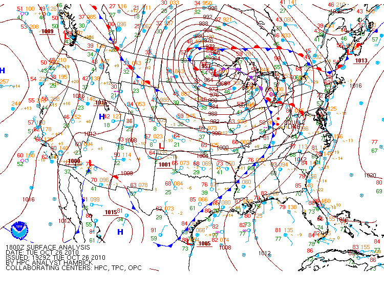
During the late morning and early afternoon hours on Tuesday (October 26th, 2010) a cold front associated with a occluded storm system over the Upper Midwest region approached northern Alabama and Southern Middle Tennessee. This storm system set a record low 955 mb central low pressure reading on October 26th at 513 pm in Big Fork, Minnesota. High temperatures were in the upper 70s to lower 80s just ahead of the front and in the upper 60s to lower 70s behind it. The air mass ahead of the front was also very moist with dewpoints around 70 degrees across northern Alabama. As the cold front pushed into the forecast area, severe supercell thunderstorms developed ahead of and along the front. The coverage of storms was widely scattered in the late morning through about 2 pm, before increasing noticably as the front neared northern Alabama during the middle of the afternoon. Numerous storms exhibited supercell characteristics and low to mid-level rotation. Reports of wall clouds associated with these storms were also common. In all, four tornadoes touched down with these storms, before the activity pushed eastward into Georgia during the evening hours. |
|
Figure 1. October 26th 2010 - 1 pm CDT Surface Analysis |
|
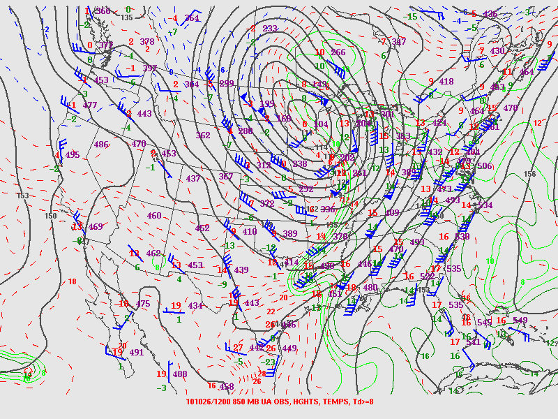
Figure 2. October 26th, 2010 - 7 am CDT 850mb (Upper Air) Analysis |
|
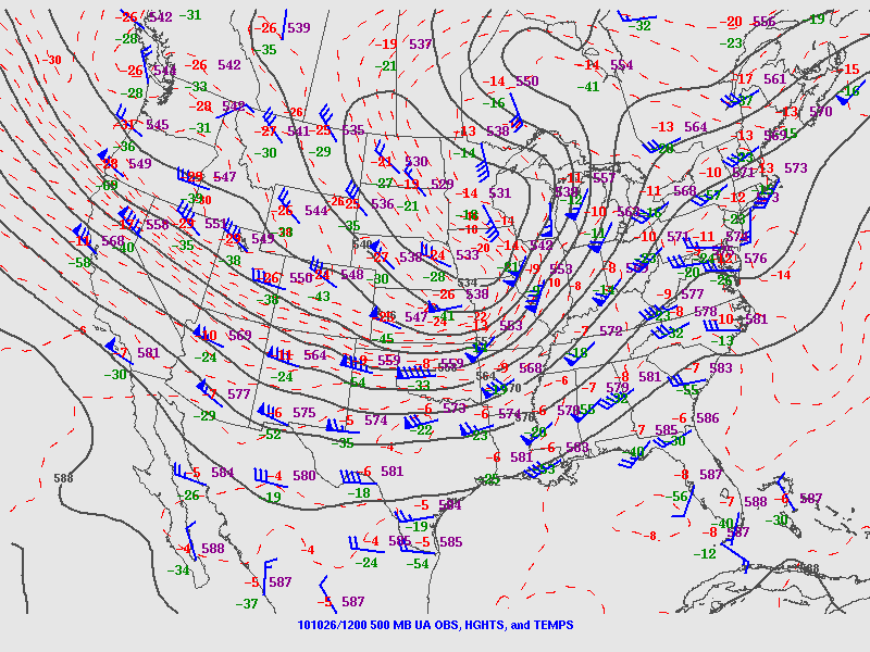
Figure 3. October 26th 2010 - 7 am CDT 500mb (Upper Air) Analysis |
|
Two Main Ingredients were in place by the late afternoon hours for severe thunderstorm development capable of damaging winds and isolated tornadoes across the Huntsville Forecast Area. 1. A strong cold front streching south from a record setting occluded low presssure system moving into northern Alabama and central Tennessee. This is shown in figure 1 above. During the day on Tuesday, warm southerly flow allowed temperatures to climb into upper 70s to lower 80s at many locations, while dew point temperatures rose to around 70 degrees. This is a very moist air mass for the end of October. As the upper strong front moved into the region, the warm/moist airmass at the low-levels, combined with colder air aloft to generate increased instability. This lead to further rapid rising motion and the development of severe thunderstorms. 2. In addition, strong speed shear and good directional shear was present ahead of this cold front. This can be shown by looking at figures 2 and 3 above. At 850 mb (~4000 to 5000 ft) a very strong jet streak of 50 to 60 knots was present. The winds within this jet streak were from the south southwest ahead of the front. This is shown in figure 2. Above this at 500 mb (~15,000 to 18,000 feet), winds were strong as well with a 90 to 100 knot jet streak at this level over Missouri and Ilinois along and behind the front. The winds were from the west to southwest ahead of the front at this level. This produced a high shear environment. In fact, the speed shear might have been too powerful for stronger tornadoes to develop. |


 Local Radar
 Weather Map