
A heat wave over the Southwest will intensify this week, peaking and expanding into the Intermountain West and northern High Plains this weekend. Critical to extremely critical fire weather conditions are forecast from the Northwest and the northern Great Basin this weekend. Particularly Dangerous Situation Red Flag Warnings have been issued. Read More >
 |
||||||||||||||||||||||||||||||||||||||||||||||||||||||||
|
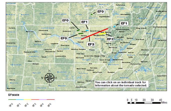
Event Overview A storm system with a potent upper level low over Missouri and an attendant cold front extending into eastern Texas was in place on the morning of March 2nd, 2012. As the morning progressed, a disturbance pushed ahead of the front across a very unstable air mass (with CAPE values between 1000 and 2000 J/kg) over Mississippi, Alabama, Tennessee, and Kentucky. As this disturbance pushed northeast from Mississippi into northeastern Tennessee between 8 AM and 1 PM, 0-1 km helicity values maximized at values between 400 m2/s2 and 500 m2/s2. This high instability and strong low level shear came together and produced tornadoes during the morning hours. In all, three tornadoes affected northern Alabama between 9:10 am and 10:15 am, one EF-1, an EF-2 and an EF-3. As the day progressed, the atmosphere became favorable for large hail and remained capable of producing weaker tornadoes as the cold front pushed east towards the Tennessee Valley. In the afternoon and evening hours, the Huntsville Forecast area (as well as much of the Tennessee and Ohio Valley) was pounded with large hail. Numerous reports of hail larger than one inch in diameter were received, with some hail reaching the size of baseballs (2.75" in diameter) and softballs (4.25" in diameter). In addition, despite being weaker than the mid-morning tornadoes, four additional EF-0 to EF-1 tornadoes occurred between 1 pm and 4 pm. |
||||||||||||||||||||||||||||||||||||||||||||||||||||||||
|
||||||||||||||||||||||||||||||||||||||||||||||||||||||||
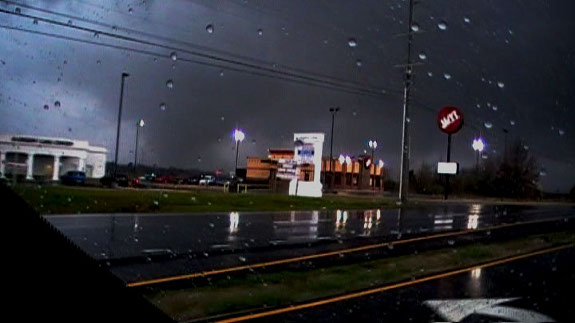 This picture is courtesy of David Ruffini and was taken on 231 in Meridianville.
|


 Local Radar
 Weather Map