|
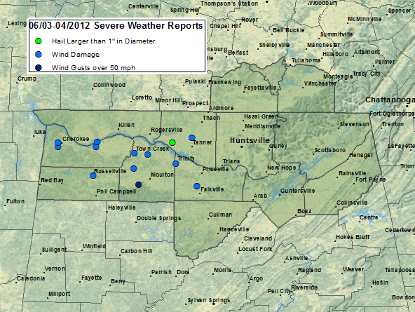
On June 3rd, 2012 a weak frontal boundary was in place just north of the Huntsville Forecast area. Moisture advection south of this boundary pulled very moist air northward from the Gulf of America into central and portions of northern Alabama (especially west of I-65 and south of the Tennessee River). This produced a very moist atmospheric column with precipitable water values climbing to between 1.5 and 2.0 inches. Starting Sunday afternoon (June 3rd, 2012) and continuing through Monday morning (June 4, 2012), multiple disturbances (sources of lift) pushed through upper level northwesterly flow (700 mb) and across this frontal boundary. The strongest of which pushed southward from Tennessee into northern Alabama around midnight into the early morning hours before exiting the area just before 10 AM on Monday. Before doing so, numerous strong to severe storms developed with this disturbance. Below is a plot of the severe weather reports received so far with this event. Click here to see more details about the severe weather reports received below.
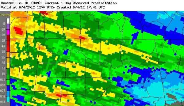
Also, much needed heavy rain amounts between 1 to 2 inches fell, with locally heavier amounts around 3 inches in some locations. Luckily, due to dry conditons already in place, no flash flooding was observed. Below is an image of observed rainfall totals beginning on 7 AM on Sunday through 7 AM on Monday. Below are rainfall totals from 06/03/2012 at 7am through 06/04/2012 at 7 am. |
|
|


 Local Radar
 Weather Map