|
07/06/2012 Severe Weather Summary
On July 6th, 2012 a weak convergence boundary stretched northwest from southern Georgia into central Alabama and to just across the northern Mississippi/Alabama state line. After some initial high cloud cover in the morning hours, strong heating resulted in temperatures climbing to over 100 degrees in northwestern portions of Alabama near this boundary. As the convective temperatures in the mid 90s were met in the early afternoon hours, showers and storms developed in northwestern Alabama and northeastern Mississippi. These storms continued to increase in intensity and coverage over northwestern Alabama through the mid-afternoon hours. Severe thunderstorm warnings were issued and the most severe storm of the day developed over the Florence and Petersville communities in Lauderdale County. Damaging winds and quarter size hail were produced by this storm. Some of the damage was extensive. One home, approximately 5 miles north of the Petersville community, was heavily damaged. Also, roof damage occurred at the Wilson Elementary School, numerous trees and power lines were blown down, and a roof was blown off of a manufactured home. Below is a plot of the severe weather reports that have been received so far.
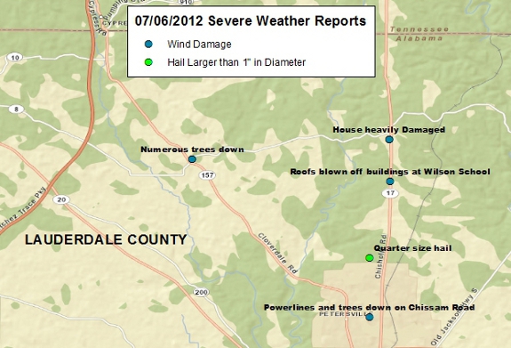
Click here to see more details about the severe weather reports received.
More Needed Rainfall also Fell
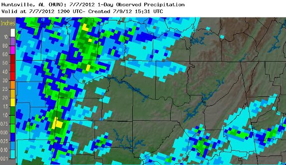
The strong to severe storms did bring another quick shot of needed rainfall to northwestern portions of northern Alabama, mainly near the AL/MS state line. One to two inches of rainfall were the highest amounts received, mainly in the Florence and Petersville communities. Further south in Colbert and Franklin counties in Alabama, rainfall amounts were generally between 0.50 and 1.5 inches. Below are rainfall totals starting on July 6th at 7 am and ending at 7 am on July 7th.
|


 Local Radar
 Weather Map