|
Winter Storm A developing area of low pressure moved out of the southern Plains on the morning of December 8. The low intensified as it tracked north and east into the Ohio Valley, spreading precipitation into the region during the afternoon. A cold air mass remained in place across much of the region, and this enabled most of the precipitation to fall as snow. There was enough warm air in the lowest levels of the atmosphere to cause a wintry mix of snow, sleet and freezing rain across northern Kentucky and parts of southern Indiana and Ohio for several hours during the afternoon and evening before precipitation changed to all snow. Light snow began falling across the Tri-State area during the mid afternoon, rapidly intensifying to heavy snow as dry air near the surface was eroded away. The heavy snow continued for about a three to five hour period at any one location as it lifted north across the region during the evening. The bulk of the heaviest snow fell during the evening rush hour and impacted thousands of motorists. Snow began tapering off from the southwest during the late evening as the low moved into the Great Lakes. Snowfall amounts ranged from around an inch across northeast Kentucky and south central Ohio, to five to eight inches in an arc extending from east central Indiana north and east through the Miami Valley and west central Ohio. There was a light ice accumulation as well across much of northern Kentucky due to the wintry mix. Strong westerly winds developed as the snow ended, with gusts from 30 to 45 mph across the region. The highest gust recorded in the region occurred at Dayton International Airport, where a gust of 51 mph was registered shortly before midnight, December 9. These winds also contributed to some blowing and drifting of snow, particularly across eastern Indiana and western Ohio. |
| Snowfall Amounts: | |||
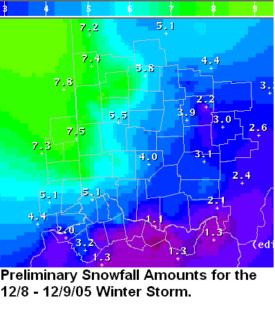 |
Snowfall amounts from Dec 8-9, 2005. | ||
| Radar images: | |||
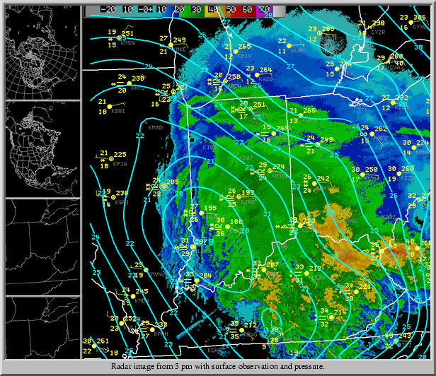 |
5 PM on December 8, at height of heaviest snowfall across Cincinnati metro area. | ||
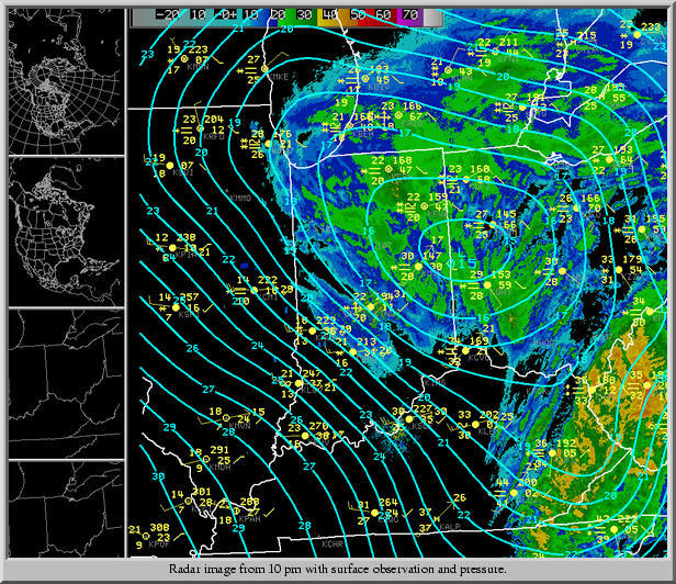 |
10 PM on December 8, as heaviest snow has shifted north into west central Ohio. | ||
PUBLIC INFORMATION STATEMENT
SPOTTER REPORTS
NATIONAL WEATHER SERVICE WILMINGTON OH
1257 PM EST FRI DEC 9 2005

THE FOLLOWING ARE UNOFFICIAL OBSERVATIONS TAKEN DURING THE PAST 24 HOURS FOR
THE STORM THAT HAS BEEN AFFECTING OUR REGION.  APPRECIATION IS EXTENDED
TO HIGHWAY DEPARTMENTS...COOPERATIVE OBSERVERS...SKYWARN SPOTTERS AND MEDIA FOR
THESE REPORTS.  THIS SUMMARY IS ALSO AVAILABLE ON OUR HOME PAGE AT
WEATHER.GOV/ILN

***********************6 HOUR SNOWFALL***********************

LOCATION               6 HOUR    TIME/DATE    COMMENTS
                     SNOWFALL       OF
                     (INCHES)   MEASUREMENT


INDIANA

...DEARBORN COUNTY...
   BRIGHT                 5.0   827 PM  12/8

...UNION COUNTY...
   LIBERTY                4.3   802 PM  12/8

KENTUCKY

...BRACKEN COUNTY...
   BROOKSVILLE            1.0   947 PM  12/8   WINTERY MIX

...CAMPBELL COUNTY...
   HIGHLAND HEIGHTS       4.3   817 PM  12/8

...GALLATIN COUNTY...
   WARSAW                 4.0   924 PM  12/8

...GRANT COUNTY...
   DRY RIDGE              0.8   935 PM  12/8   LITTLE SNOW

...MASON COUNTY...
   MAYSVILLE                T   942 PM  12/8   MOSTLY RAIN

OHIO

...BUTLER COUNTY...
   OKEANA                 6.0   945 PM  12/8
   TRENTON                5.3   912 PM  12/8

...CHAMPAIGN COUNTY...
   URBANA                 5.0   851 PM  12/8

...CLERMONT COUNTY...
   WITHAMSVILLE           4.0   950 PM  12/8

...CLINTON COUNTY...
   WILMINGTON             3.5   910 PM  12/8   NWS EMPLOYEE

...DARKE COUNTY...
   GREENVILLE             5.0   900 PM  12/8

...DELAWARE COUNTY...
   DELAWARE               2.3   924 PM  12/8

...HAMILTON COUNTY...
   HARRISON               5.0   913 PM  12/8

...LOGAN COUNTY...
   BELLEFONTAINE          4.0   903 PM  12/8

...MERCER COUNTY...
   CELINA                 6.0   830 PM  12/8

...MIAMI COUNTY...
   TROY                   4.1   812 PM  12/8
   BRADFORD               4.0   911 PM  12/8

...MONTGOMERY COUNTY...
   BROOKVILLE             4.5   808 PM  12/8
   MIAMISBURG             4.5   801 PM  12/8

...WARREN COUNTY...
   LEBANON                5.0   953 PM  12/8   NWS EMPLOYEE
   OREGONIA               4.5   810 PM  12/8
   MASON                  4.0   820 PM  12/8

********************STORM TOTAL SNOWFALL********************

LOCATION          STORM TOTAL    TIME/DATE    COMMENTS
                     SNOWFALL       OF
                     (INCHES)   MEASUREMENT


INDIANA

...DEARBORN COUNTY...
   FARMERS RETREAT        4.0   815 AM  12/9

KENTUCKY

...GALLATIN COUNTY...
   NAPOLEON               2.0   759 AM  12/9   FELL AS SNOW AND SLEET

OHIO

...ADAMS COUNTY...
   WEST UNION             3.0   809 AM  12/9

...HIGHLAND COUNTY...
   HILLSBORO              4.0   811 AM  12/9

...HOCKING COUNTY...
   LOGAN                  2.5   807 AM  12/9

...LOGAN COUNTY...
   QUINCY                 7.5   801 AM  12/9

...MADISON COUNTY...
   LONDON                 3.5   808 AM  12/9

...PICKAWAY COUNTY...
   CIRCLEVILLE            2.5   809 AM  12/9

...PIKE COUNTY...
   PIKETON                4.0   802 AM  12/9

...ROSS COUNTY...
   CHILLICOTHE            3.0   803 AM  12/9

...SCIOTO COUNTY...
   PORTSMOUTH             2.0   803 AM  12/9

...UNION COUNTY...
   MARYSVILLE             3.5   759 AM  12/9

...WARREN COUNTY...
   KINGS MILLS            6.0   817 AM  12/9

***********************SNOW ON GROUND***********************

LOCATION                 SNOW    TIME/DATE    COMMENTS
                    ON GROUND       OF
                     (INCHES)   MEASUREMENT


INDIANA

...DEARBORN COUNTY...
   LAWRENCEBURG           3.5   639 PM  12/8

...FRANKLIN COUNTY...
   BROOKVILLE             3.5   638 PM  12/8

KENTUCKY

...GALLATIN COUNTY...
   NAPOLEON               2.0   759 AM  12/9   FELL AS SNOW AND SLEET

...KENTON COUNTY...
   COVINGTON              4.0   736 PM  12/8

...LEWIS COUNTY...
   VANCEBURG              0.5   801 PM  12/8   SNOW SLEET ICE MIX

OHIO

...BUTLER COUNTY...
   HAMILTON               4.0   700 PM  12/8

...GREENE COUNTY...
   BEAVERCREEK            4.5   733 PM  12/8

...MIAMI COUNTY...
   TROY                   3.0   700 PM  12/8

...PREBLE COUNTY...
   CAMDEN                 4.0   735 PM  12/8

$$
|

