Wilmington, OH
Weather Forecast Office
|
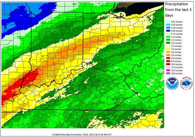
Winter Solstice Flooding and Severe Weather A plume of very moist air was pulled across the Ohio Valley ahead of a developing low pressure system. Heavy rain fell over portions of the Ohio Valley overnight Friday night December 20th into the 21st. This rain lasted into the day on the 21st, increasing flooding concerns due to the recent snow melt and causing minor flooding during the day. The low pressure system then tracked northeastward and across the Ohio Valley Saturday night. This low continued to draw an unseasonably warm and moist air mass into our area, and brought heavy rain to a large portion of southeastern Indiana, southwestern Ohio, and northern Kentucky overnight Saturday night. This secondary wave of heavy rain brought about flash flooding, river flooding, and many areas of standing water. In addition to the heavy rain, strong winds aloft combined with the warm and unstable airmass to produce an organized line of storms that brought severe winds across portions of our area Saturday night.
|
FORECASTS
Hourly Weather Graph
Graphical Forecast
Area Forecast Graphics
Area Forecast Discussion
River Forecasts and Obs
WEATHER HISTORY
Past Observed Weather
Local Climate Graphs
Local Event Summaries
OH / ILN Tornado Climatology
This Day in Weather History
NATIONAL CENTERS
Storm Prediction Center
National Hurricane Center
Weather Prediction Center
Aviation Weather Center
Climate Prediction Center
NCEI
US Dept of Commerce
National Oceanic and Atmospheric Administration
National Weather Service
Wilmington, OH
1901 South State Route 134
Wilmington, OH 45177
937-383-0031
Comments? Questions? Please Contact Us.