WATCHES, WARNINGS, AND ADVISORIES |
||||
|---|---|---|---|---|
 |
 |
|||
DSS PACKETS |
||||
|---|---|---|---|---|
| Quad Cities DSS Packet Chicago DSS Packet Lincoln/Central Illinois DSS Packet Saint Louis DSS Packet Paducah DSS Packet |
 |
|||
WEATHER STORIES |
||||
|---|---|---|---|---|
| NWS QUAD CITIES |
| NWS CHICAGO |
| NWS LINCOLN/CENTRAL ILLINOIS |
| NWS SAINT LOUIS |
| NWS PADUCAH |
LOCAL RADAR |
||||
|---|---|---|---|---|
SURFACE OBSERVATIONS AND ROAD CONDITIONS |
||||
|---|---|---|---|---|
| Current Surface Observations | IDOT Travel Information | |||
DAY 1 FORECASTS |
||||
|---|---|---|---|---|
 |
 |
 |
 |
|
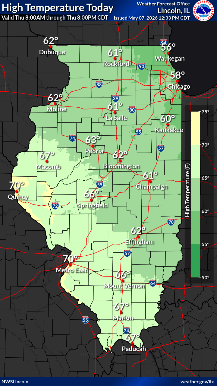
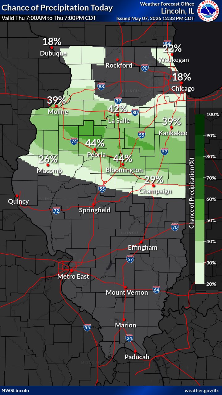
| Maximum Temperature | Precipitation Chance Today | Rainfall Amount Today | Max Wind Gust Today | |
 |
 |
 |
 |
|
| Minimum Temperature | Precipitation Chance Tonight | Rainfall Amount Tonight | Max Wind Gust Tonight | |
DAY 2 FORECASTS |
||||
 |
 |
 |
 |
|
| Maximum Temperature | Precipitation Chance Tomorrow | Rainfall Amount Tomorrow | Max Wind Gust Tomorrow | |
 |
 |
 |
 |
|
| Minimum Temperature | Precipitation Chance Tomorrow Night | Rainfall Amount Tomorrow Night | Max Wind Gust Tomorrow Night | |
DAY 3 FORECASTS |
||||
 |
 |
 |
 |
|
| Maximum Temperature | Precipitation Chance | Rainfall Amount | Max Wind Gust | |
CUMULATIVE FORECASTS |
||||
 |
 |
 |
||
| Storm Total (Days 1 -7) Forecast Precipitation | Storm Total (Days 1 -3) Forecast Snow | Storm Total (Days 1 -3) Forecast Ice | ||
ILLINOIS/NATIONAL SEVERE WEATHER OUTLOOKS THROUGH DAY 7 FROM THE SPC |
||||
|---|---|---|---|---|
 |
 |
 |
 |
|
| Mesoscale Discussion | SPC Convective Outlook for Illinois: Day 1 | SPC Convective Outlook for Illinois: Day 2 | SPC Convective Outlook for Illinois: Day 3 | |
 |
 |
 |
 |
|
| SPC Convective Outlook: Day 4 | SPC Convective Outlook: Day 5 | SPC Convective Outlook: Day 6 | SPC Convective Outlook: Day 7 | |
OBSERVED STORM DAMAGE |
||||
 |
 |
Storm Survey Information | ||
| Yesterday's SPC Storm Reports | Today's SPC Storm Reports | |||
NATIONAL SEVERE WEATHER OUTLOOKS DAYS 1-3 FROM THE SPC |
||||
 |
 |
 |
 |
|
| SPC Convective Outlook: Day 1 | SPC Convective Outlook: Day 1 Tornado Probabilities "Probability of a tornado within 25 miles of a point. Hatched area denotes 10%+ probability of EF2-EF5 tornadoes within 25 miles of a point." (SPC) |
SPC Convective Outlook: Day 1 Wind Probabilities "Probability of damaging thunderstorm winds or wind gusts of 50 knots (58 mph) or higher within 25 miles of a point. Hatched area denotes 10% or greater probability of wind gusts 65 knots (75 mph) or greater within 25 miles of a point." (SPC) |
SPC Convective Outlook: Day 1 Hail Probabilities "Probability of one inch diameter hail or larger within 25 miles of a point. Hatched area denotes 10% or greater probability of two inch diameter hail or larger within 25 miles of a point." (SPC) |
|
 |
 |
 |
 |
|
| SPC Convective Outlook: Day 2 | SPC Convective Outlook: Day 2 Tornado Probabilities "Probability of a tornado within 25 miles of a point. Hatched area denotes 10%+ probability of EF2-EF5 tornadoes within 25 miles of a point." (SPC) |
SPC Convective Outlook: Day 2 Wind Probabilities "Probability of damaging thunderstorm winds or wind gusts of 50 knots (58 mph) or higher within 25 miles of a point. Hatched area denotes 10% or greater probability of wind gusts 65 knots (75 mph) or greater within 25 miles of a point." (SPC) |
SPC Convective Outlook: Day 2 Hail Probabilities "Probability of one inch diameter hail or larger within 25 miles of a point. Hatched area denotes 10% or greater probability of two inch diameter hail or larger within 25 miles of a point." (SPC) |
|
 |
 |
|||
| SPC Convective Outlook: Day 3 | SPC Convective Outlook: Day 3 Total Probabilities "Probability of severe weather within 25 miles of a point. Hatched area denotes 10%+ probability of significant severe weather within 25 miles of a point." (SPC) |
|||
ILLINOIS EXCESSIVE RAINFALL OUTLOOKS THROUGH DAY 5 FROM THE WPC |
||||
|---|---|---|---|---|
 |
 |
 |
 |
|
| Mesoscale Precipitation Discussion | Excessive Rainfall Outlook: Day 1 | Excessive Rainfall Outlook: Day 2 | Excessive Rainfall Outlook: Day 3 | |
 |
 |
 |
||
| Excessive Rainfall Outlook: Day 4 | Excessive Rainfall Outlook: Day 5 | Next Week's Risk of Heavy Precipitation | ||
PRECIPITATION FORECASTS THROUGH DAY 7 |
||||
|
|
|
|
|
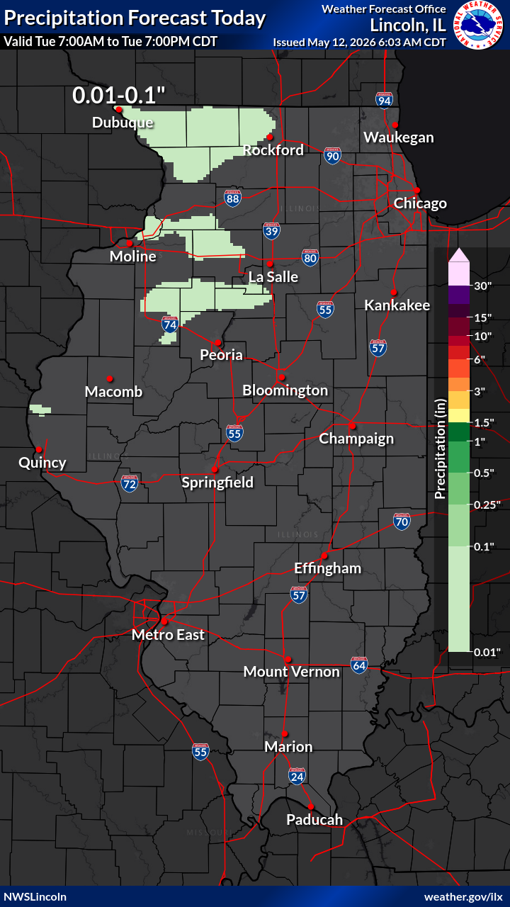
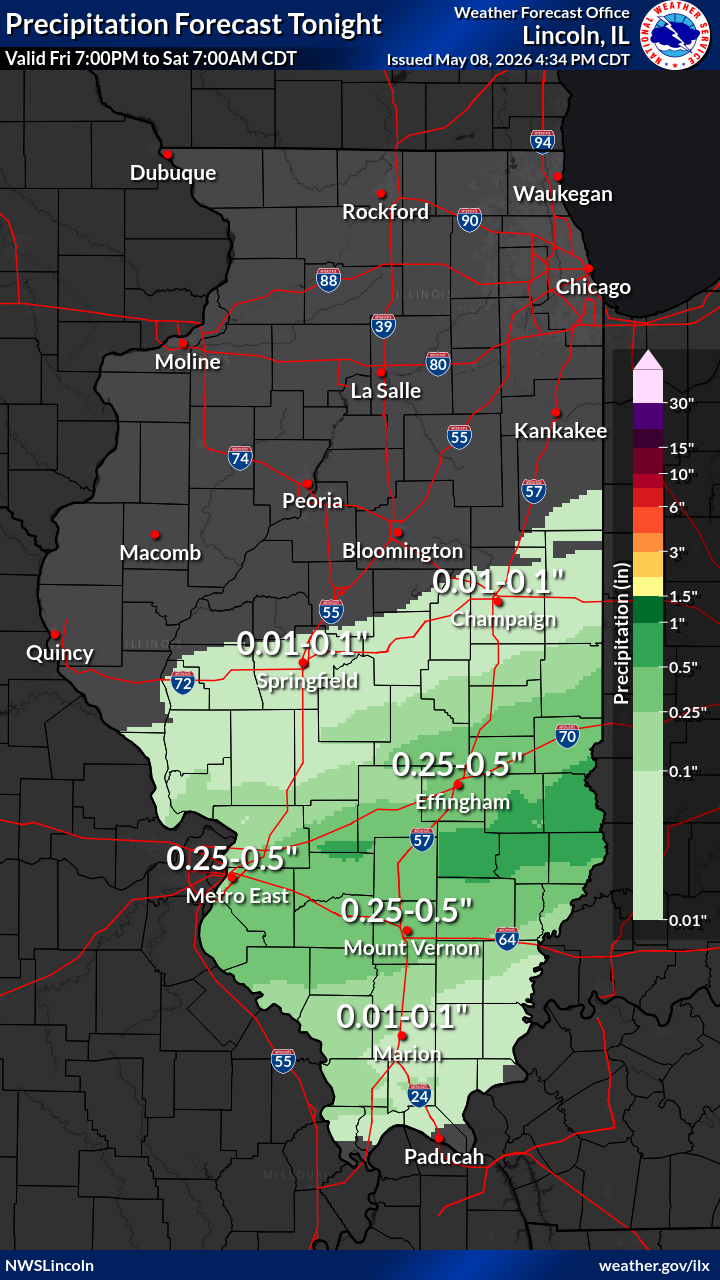
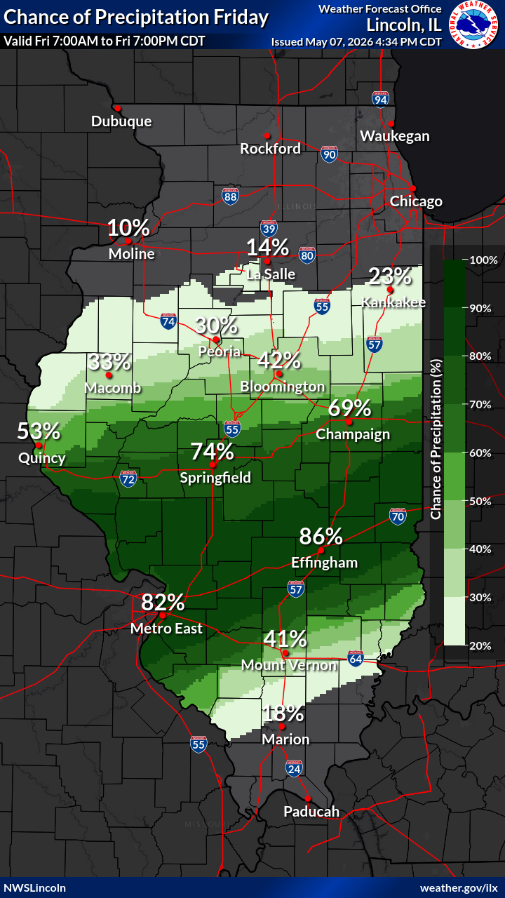
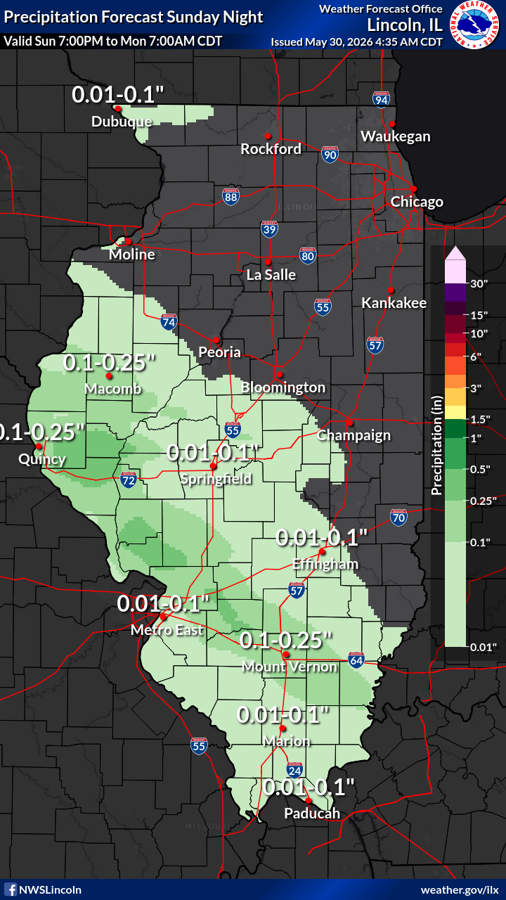
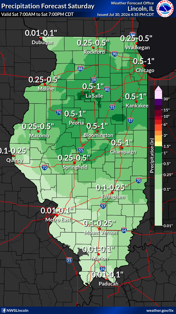
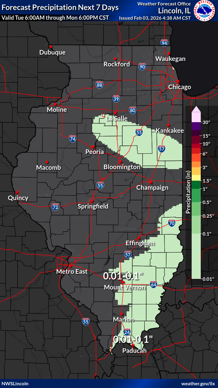
| 12-Hr Precipitation Forecast: Today | 12-Hr Precipitation Forecast: Tonight | 12-Hr Precipitation Forecast: Day 2 | Day 1-7 Total Precipitation Forecast | |
 |
 |
 |
 |
|
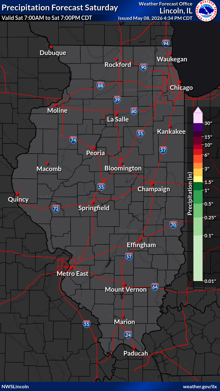
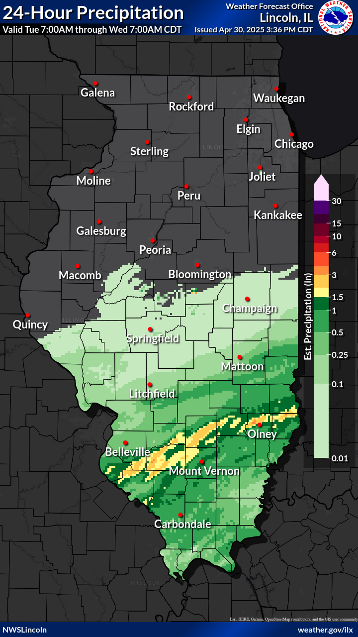
| 24 Hour Precipitation Forecast: Day 1 | 24 Hour Precipitation Forecast: Day 2 | 24 Hour Precipitation Forecast: Day 3 | Day 1-7 Total Precipitation Forecast | |
OBSERVED PRECIPITATION |
||||
 |
 |
 |
 |
|
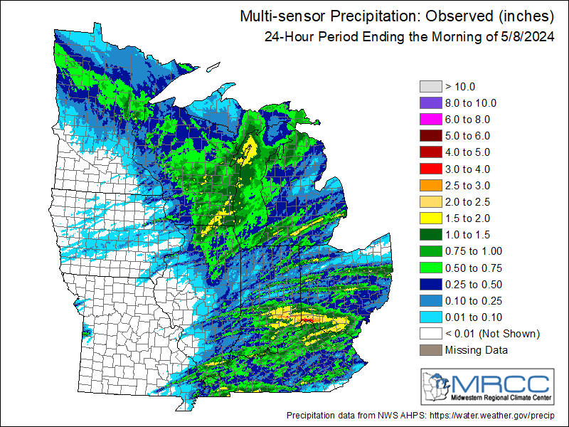
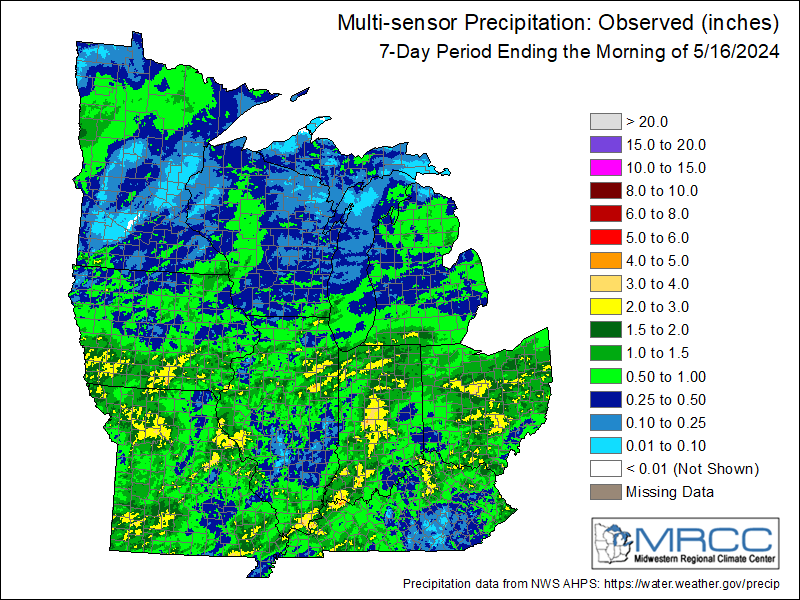
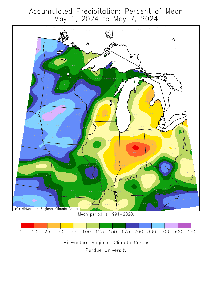
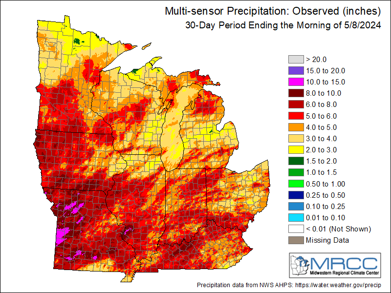
| Estimated 24 Hour Past Precipitation (updated around 1745z daily) | 24 Hour Precipitation Totals | 7 Day Precipitation Totals | 7 Day Accumulated Precipitation Percent of Mean | |
 |
 |
|||
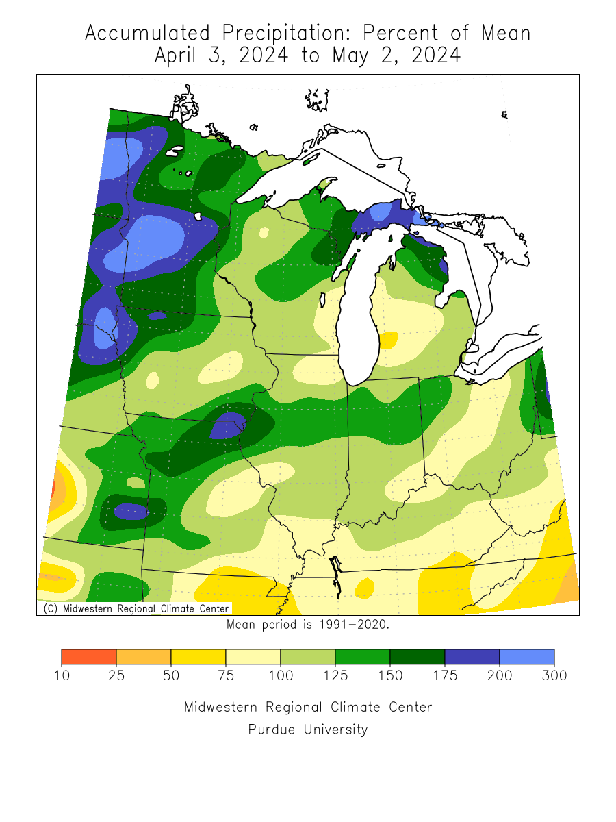
| 30 Day Precipitation Totals | 30 Day Accumulated Precipitation Percent of Mean | |||
MEDIUM-LONG RANGE PRECIPITATION OUTLOOKS |
||||
|
 |
 |
||
| Next Week's Risk of Heavy Precipitation | 6-10 Day Precipitation Outlook | 8-14 Day Precipitation Outlook | ||
 |
 |
 |
||
| 3-4 Week Precipitation Outlook | One Month Precipitation Outlook | Three Month Precipitation Outlook | ||
RIVER FORECASTS |
||||
| River Forecasts for Illinois | ||||
NATIONAL HEAT OUTLOOKS FOR THE NEXT 14 DAYS |
||||
|---|---|---|---|---|
 |
 |
 |
||
| Next Week's Risk of Hazardous Temperatures | 6-10 Day Temperature Outlook | 8-14 Day Temperature Outlook | ||
MAXIMUM TEMPERATURE AND HEAT INDEX FORECASTS THROUGH DAY 3 |
||||
|
 |
|
 |
|
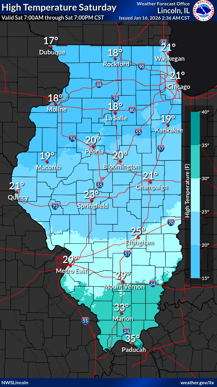
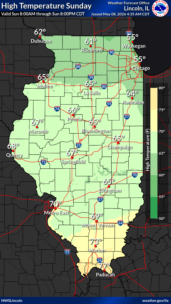
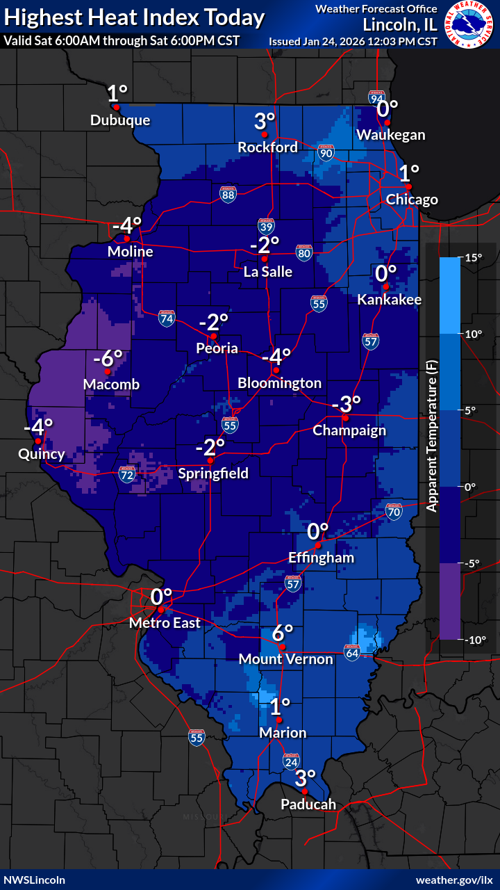
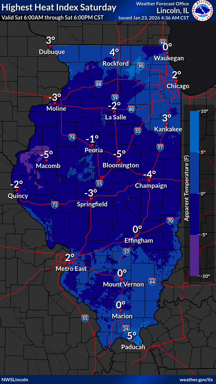
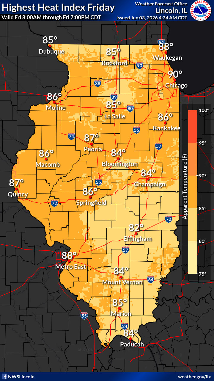
| Day 1 Maximum Temperature | Day 1 Heat Index | Day 2 Maximum Temperature | Day 2 Heat Index | |
|
 |
|||
| Day 3 Maximum Temperature | Day 3 Heat Index | |||
LONG RANGE HEAT OUTLOOKS |
||||
 |
 |
 |
||
| 3-4 Week Temperature Outlook | One Month Temperature Outlook | Three Month Temperature Outlook | ||
NATIONAL FIRE WEATHER OUTLOOKS THROUGH DAY 8 FROM THE SPC |
||||
|---|---|---|---|---|
 |
 |
 |
 |
|
| Fire Weather Outlook: Day 1 | Fire Weather Outlook: Day 2 | Fire Weather Outlook: Day 3 | Fire Weather Outlook: Day 4 | |
 |
 |
 |
 |
|
| Fire Weather Outlook: Day 5 | Fire Weather Outlook: Day 6 | Fire Weather Outlook: Day 7 | Fire Weather Outlook: Day 8 | |
RELATIVE HUMIDITY/WIND/PRECIPITATION FORECASTS THROUGH DAY 3 |
||||
 |
 |
 |
||
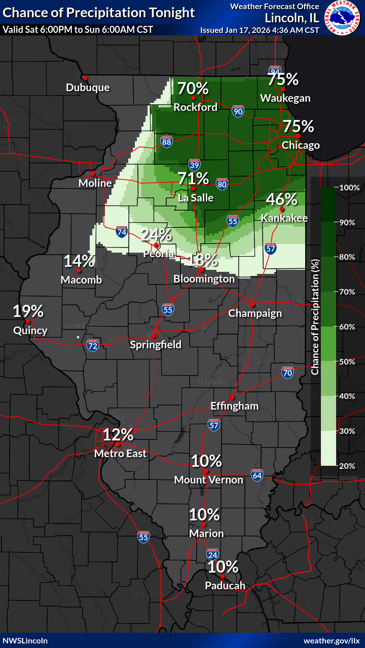
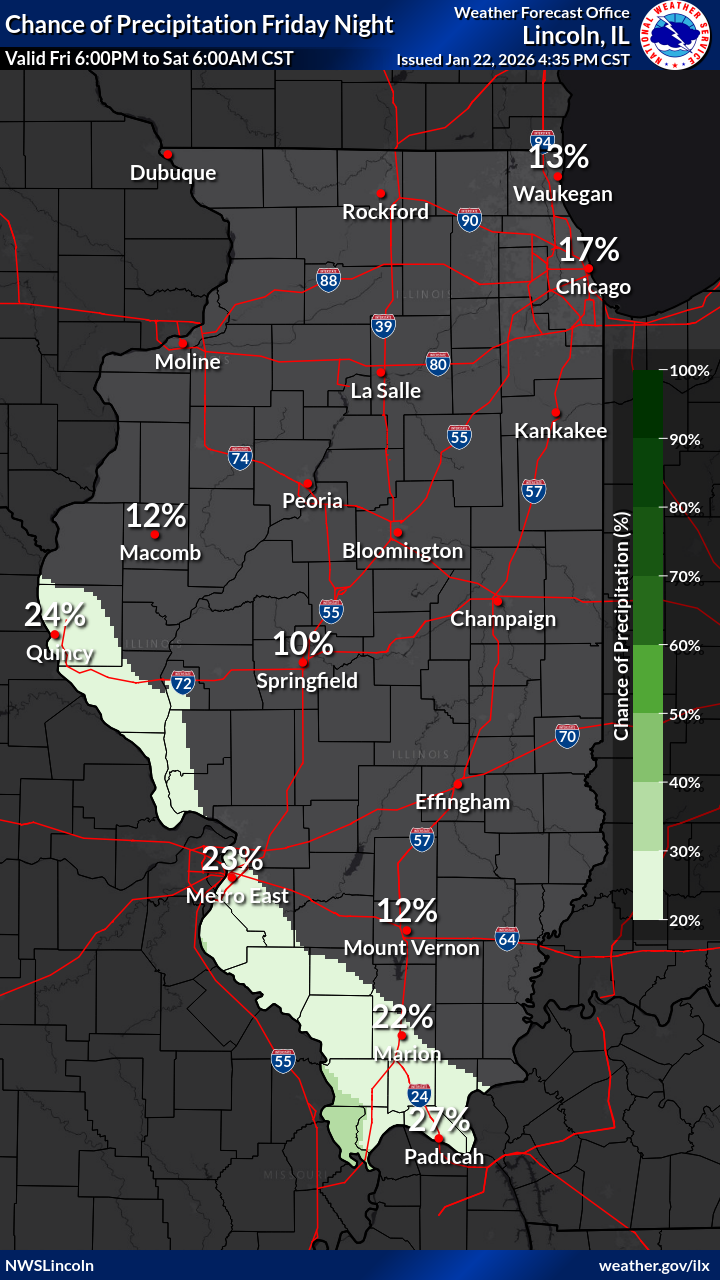
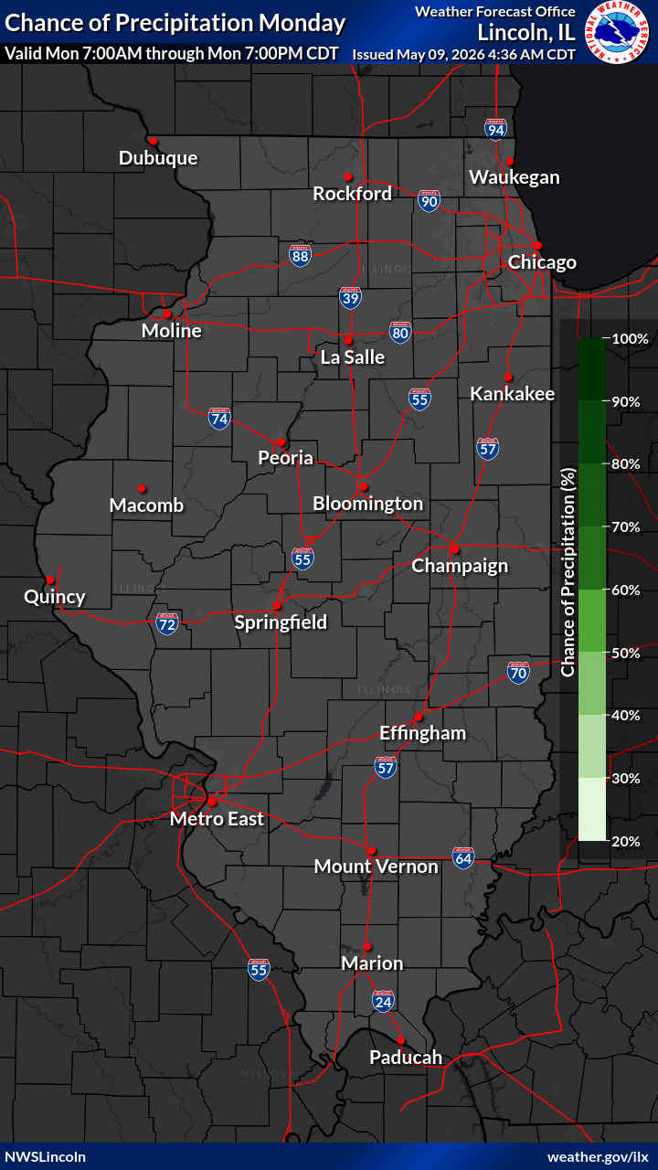
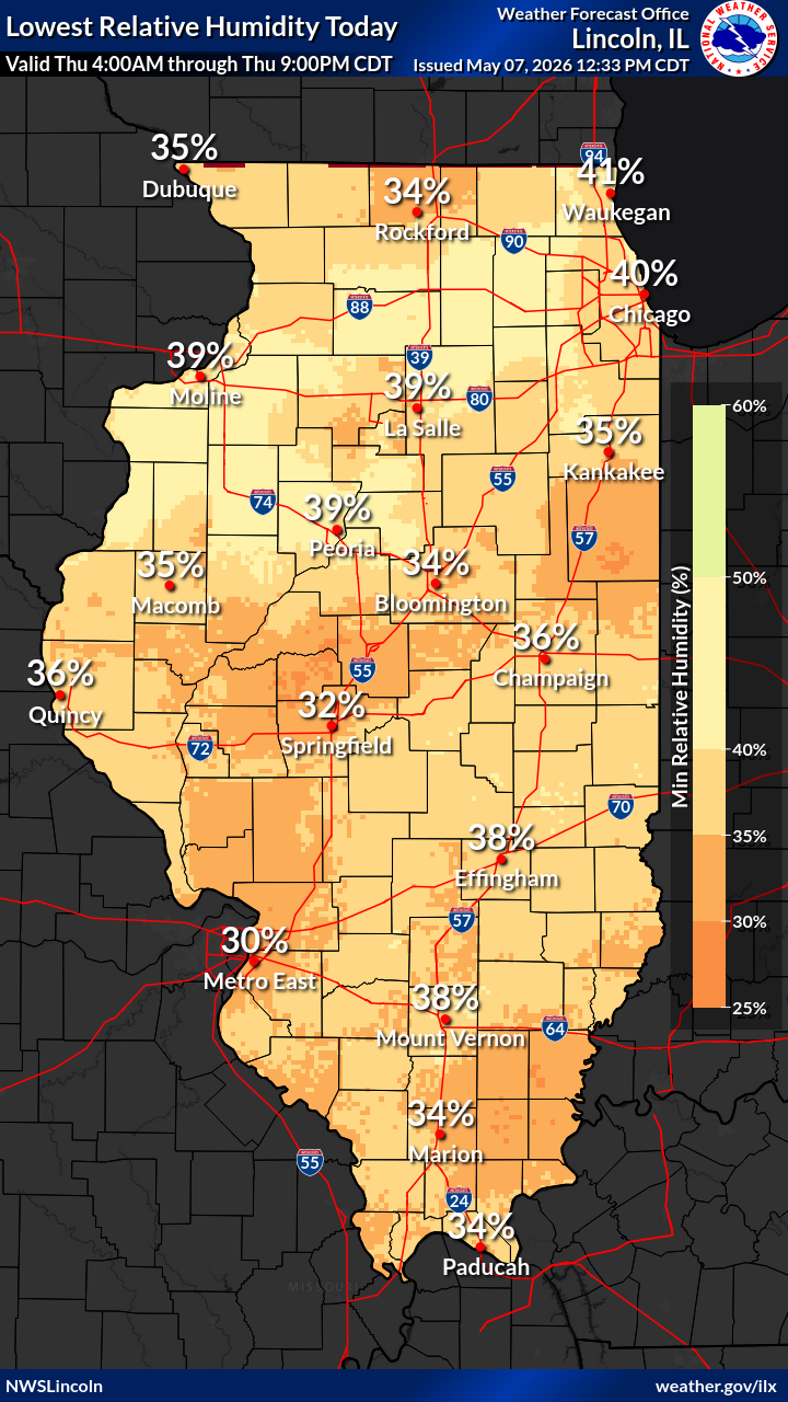
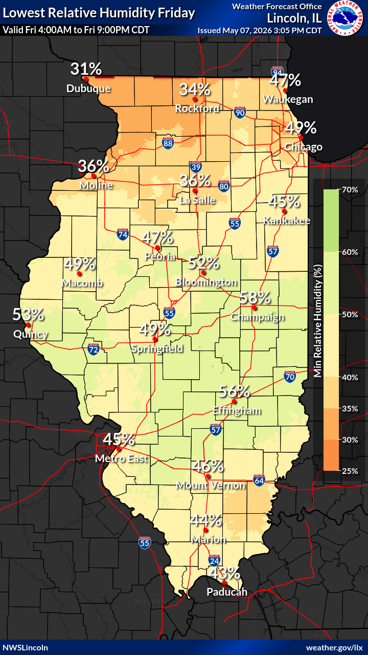
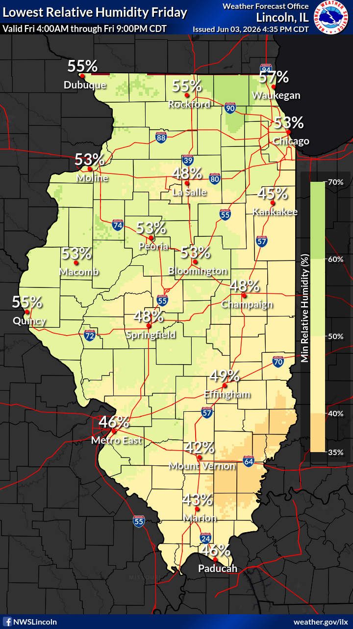
| Day 1 Minimum Relative Humidity | Day 2 Minimum Relative Humidity | Day 3 Minimum Relative Humidity | ||
|
|
|
||
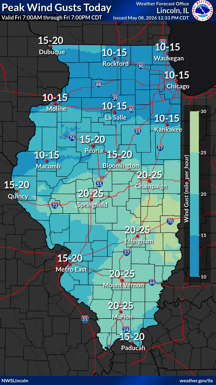
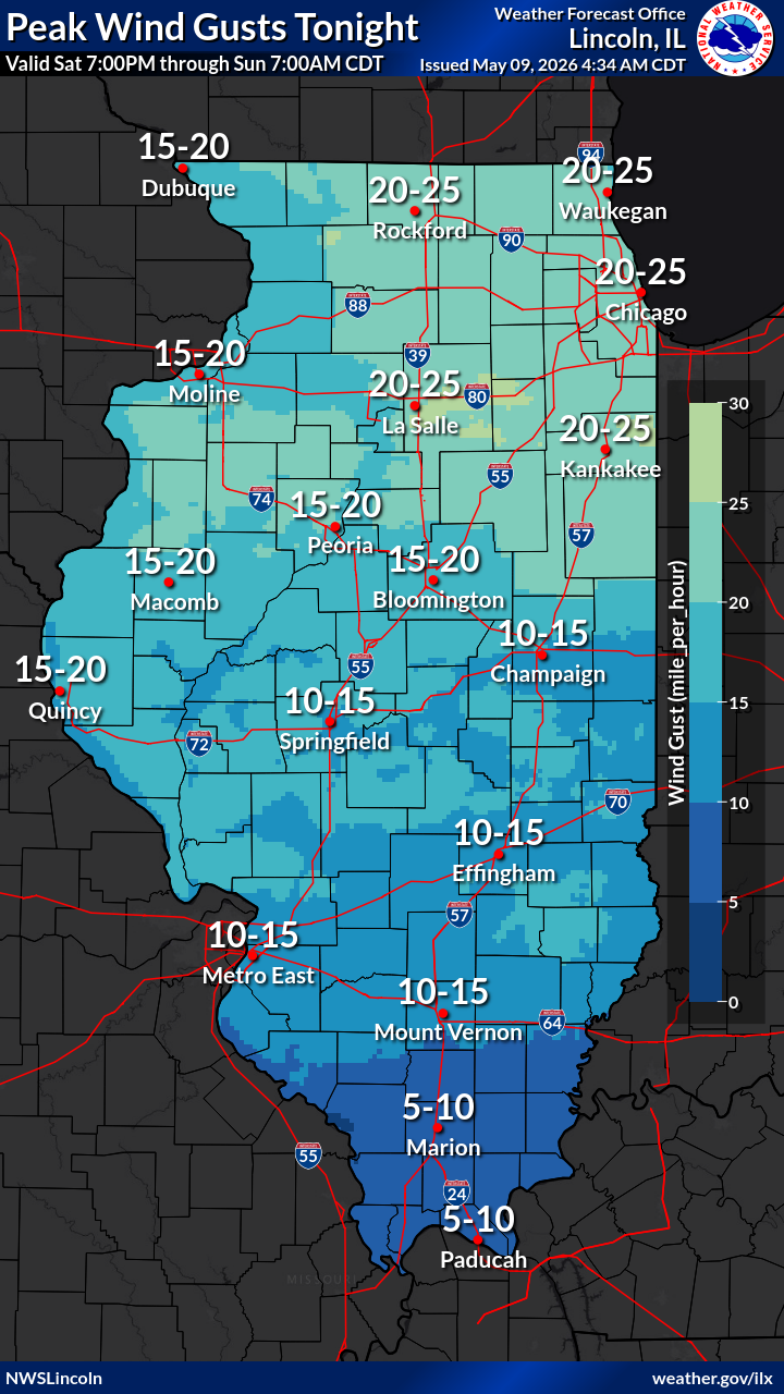
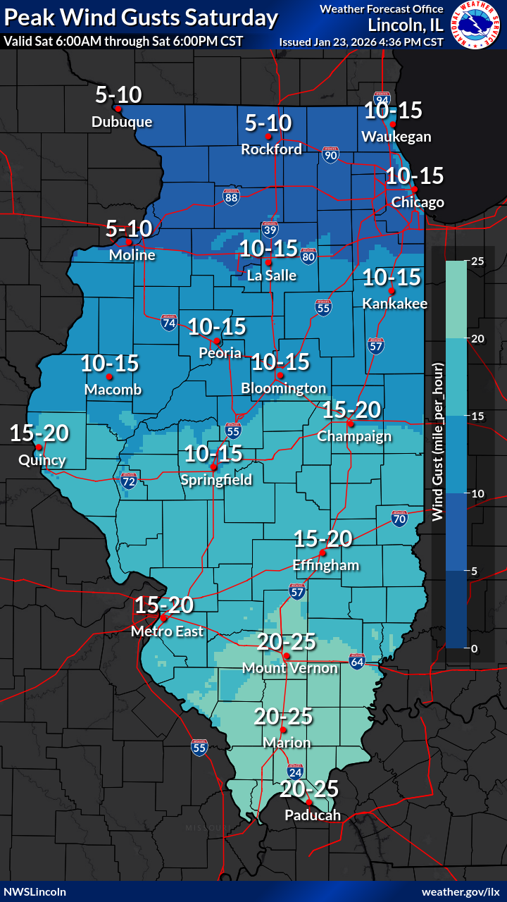
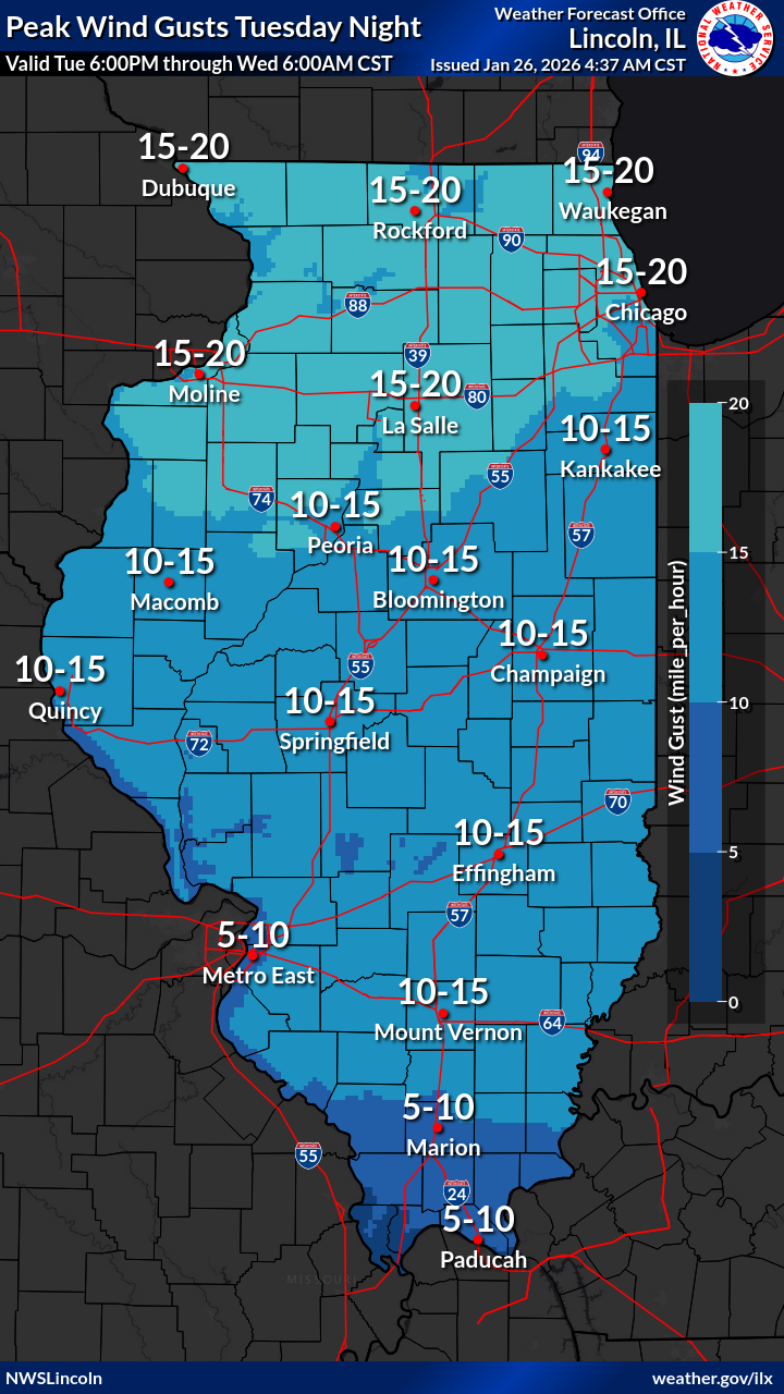
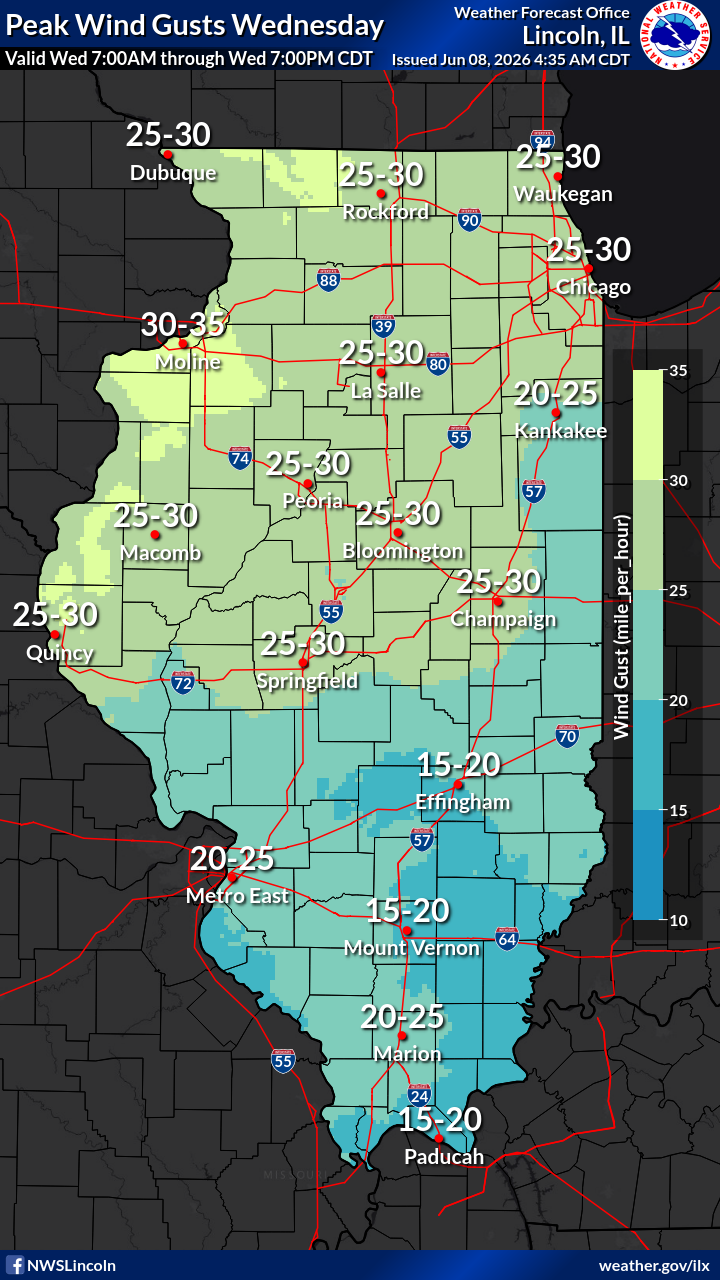
| Day 1 Maximum Wind Gust | Day 2 Maximum Wind Gust | Day 3 Maximum Wind Gust | ||
|
|
|||
| Estimated 24 Hour Past Precipitation (updated around 1745z daily) | Total Forecasted Precipitation Days 1-7 | |||
FIRE WEATHER INDICES |
||||
 |
 |
 |
 |
|
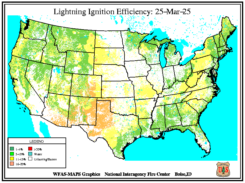
| Drought Monitor | Palmer Drought Severity Index | Keetch-Byram Drought Index | Lightning Ignition Efficiency | |
 |
 |
 |
 |
|
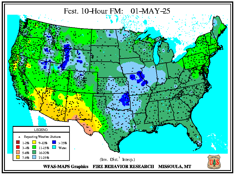
| 10 Hour Dead Fuel Forecast | 10 Hour Dead Fuel Observation | 100 Hour Dead Fuel Observation | 1000 Hour Dead Fuel Observation | |
LONG RANGE TEMPERATURE AND PRECIPITATION OUTLOOKS |
||||
 |
 |
|
|
|
| 1 Month Temperature Outlook | 1 Month Precipitation Outlook | 3 Month Temperature Outlook | 3 Month Precipitation Outlook | |
| Evaporative Demand Drought Index (EDDI) | The Evaporative Demand Drought Index is an experimental drouht monitoring and early warning duiance tool. It analyzes the atmospheric evaporative demand ("thirst of the atmosphere) over space and time and can be used to identify areas that will see increased moisture loss from evaporation (but does not take additional rainfall into account). | |||
NATIONAL HEAVY SNOWFALL OUTLOOKS THROUGH DAY 14 FROM THE WPC |
||||
|---|---|---|---|---|
|
 |
 |
 |
|
| Mesoscale Precipitation Discussion | Probability of at Least 4 Inches of Snow: Day 1 | Probability of at Least 4 Inches of Snow: Day 2 | Probability of at Least 4 Inches of Snow: Day 3 | |
 |
 |
 |
 |
|
| Probability of Exceeding 0.25 Inches of Snow: Day 4 | Probability of Exceeding 0.25 Inches of Snow: Day 5 | Probability of Exceeding 0.25 Inches of Snow: Day 6 | Probability of Exceeding 0.25 Inches of Snow: Day 7 | |
 |
|
|||
| Next Week's Risk of Heavy Snow | Next Week's Risk of Hazardous Temperatures | |||
ICE AND PROBABILISTIC SNOWFALL FORECAST THROUGH DAY 3 |
||||
|
|
 |
 |
|
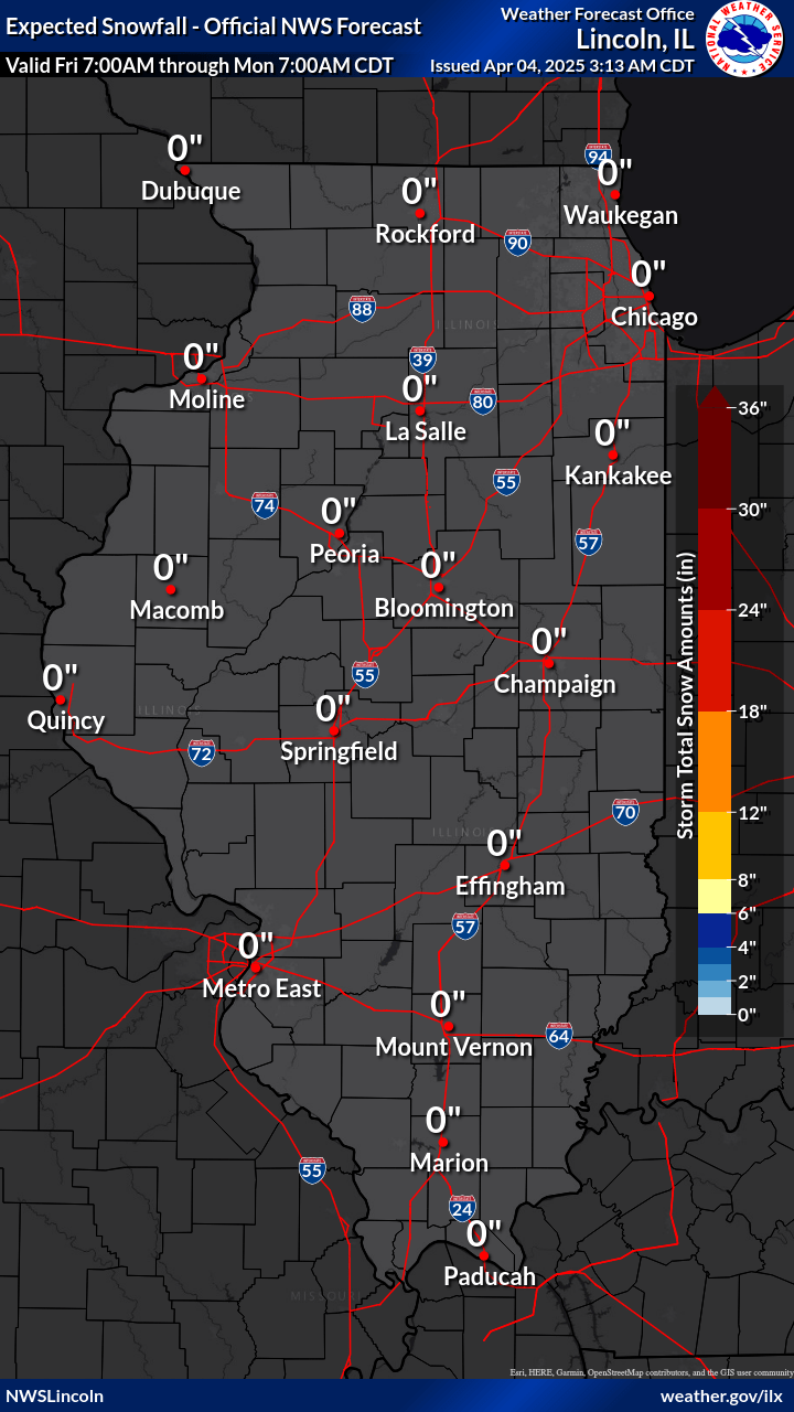
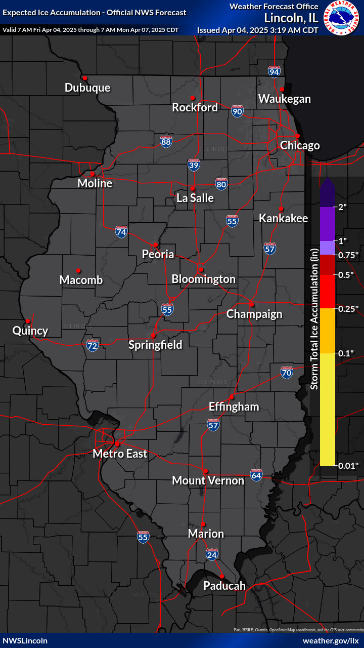
| Day 1-3 Storm Total Snow Forecast | Day 1-3 Storm Total Ice Forecast | Day 1-3 Probability of 9 in 10 Chance (90%) of Higher Snowfall | Day 1-3 Probability of 1 in 10 Chance (10%) of Higher Snowfall | |
PROBABILITY OF EXCEEDANCE SNOWFALL FORECAST THROUGH DAY 3 |
||||
 |
 |
 |
 |
|
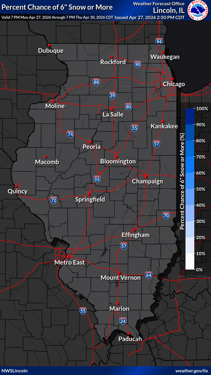
| Day 1-3 Percent Chance of 0.1+" Snow | Day 1-3 Percent Chance of 1+" Snow | Day 1-3 Percent Chance of 2+" Snow | Day 1-3 Percent Chance of 4+" Snow | |
 |
 |
 |
 |
|
| Day 1-3 Percent Chance of 6+" Snow | Day 1-3 Percent Chance of 8+" Snow | Day 1-3 Percent Chance of 12+" Snow | Day 1-3 Percent Chance of 18+" Snow | |
OBSERVED SNOWFALL |
||||
 |
 |
 |
 |
|
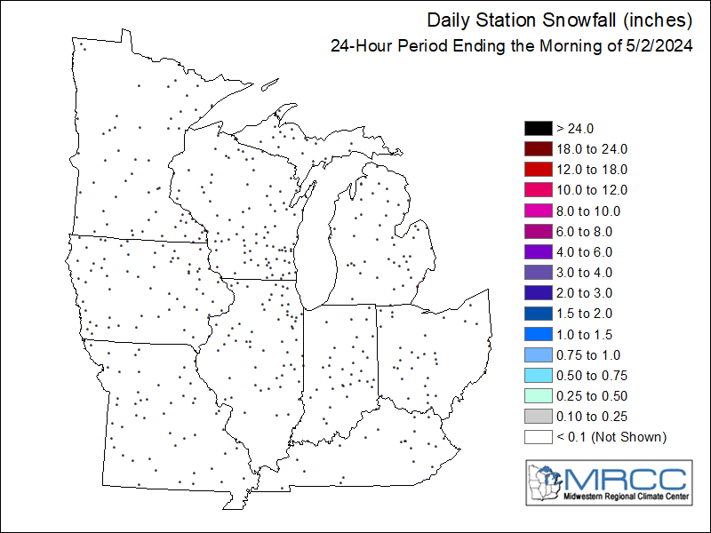
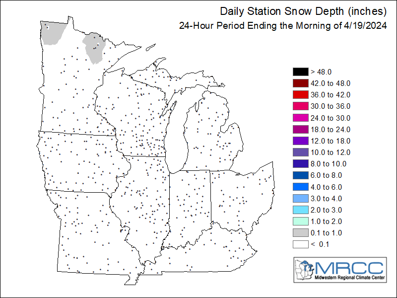
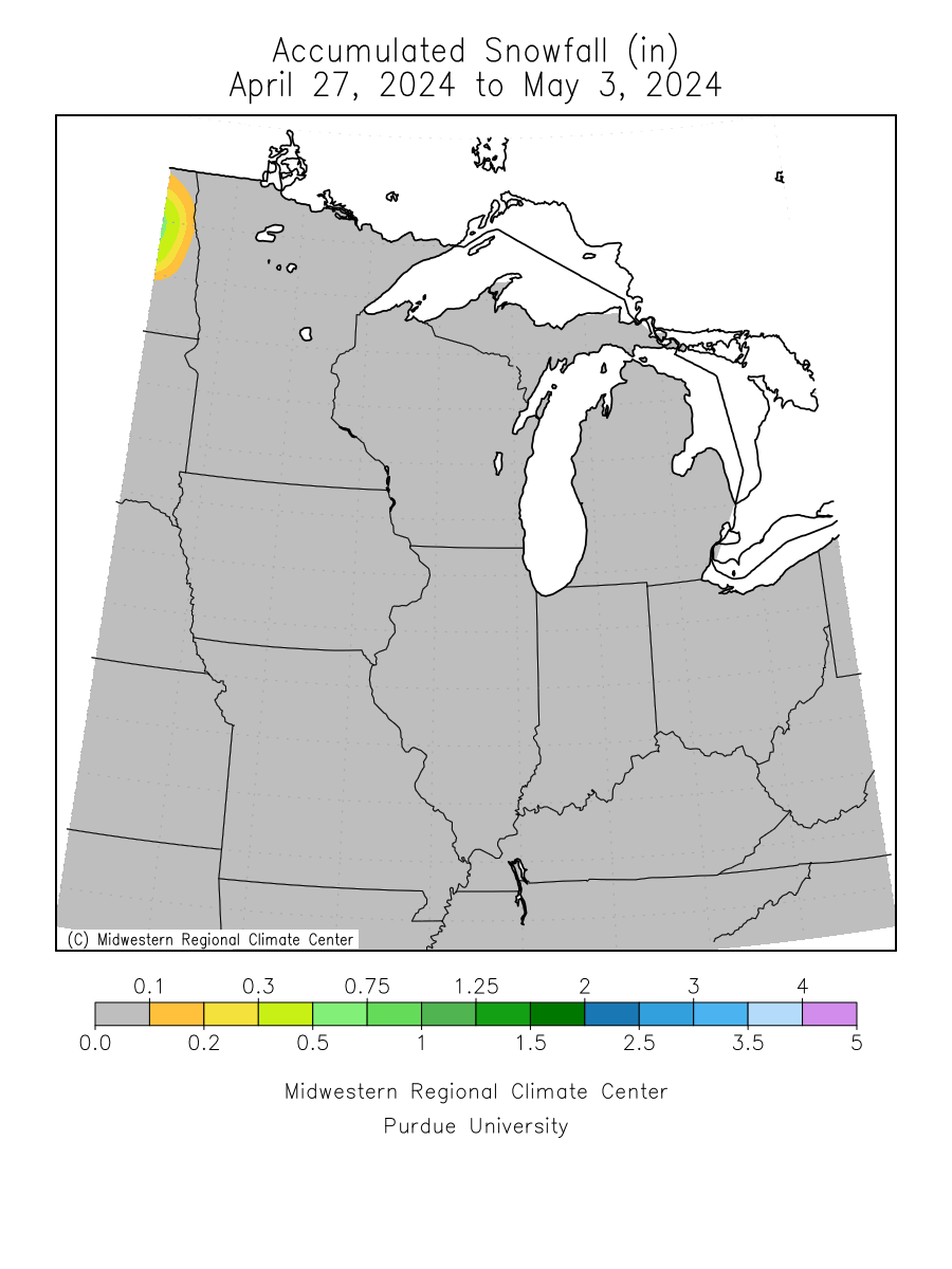
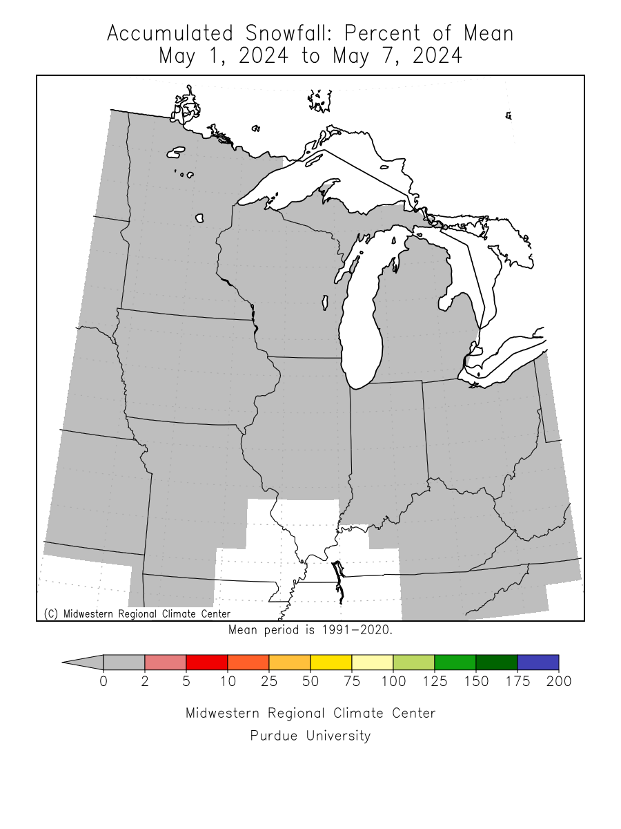
| 24 Hour Observed Snowfall | 24 Hour Observed Snow Depth | 7 Day Total Snowfall | 7 Day Total Snowfall Percent of Mean | |
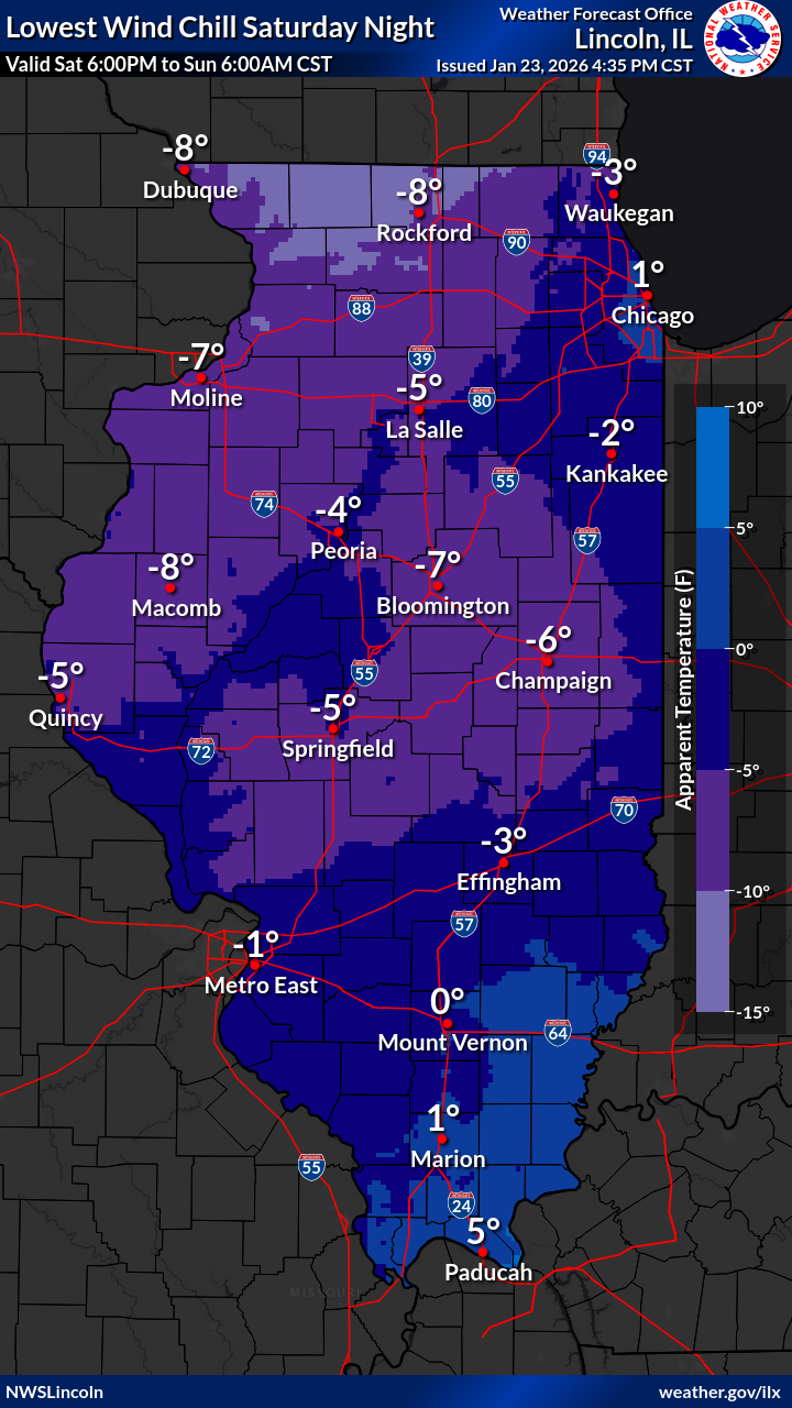
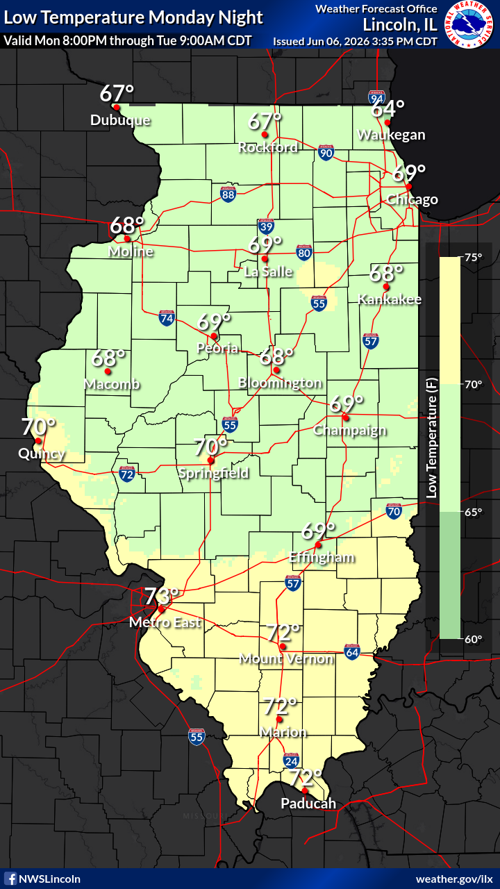
MINIMUM TEMPERATURE AND WIND CHILL FORECAST THROUGH DAY 3 |
||||
|
 |
 |
||
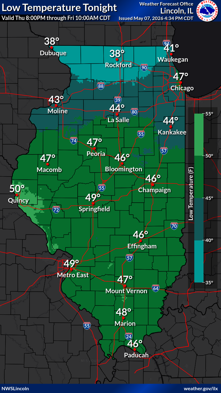
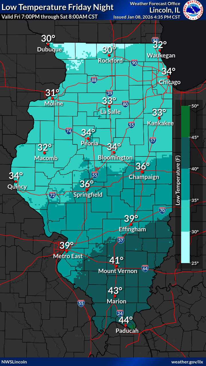
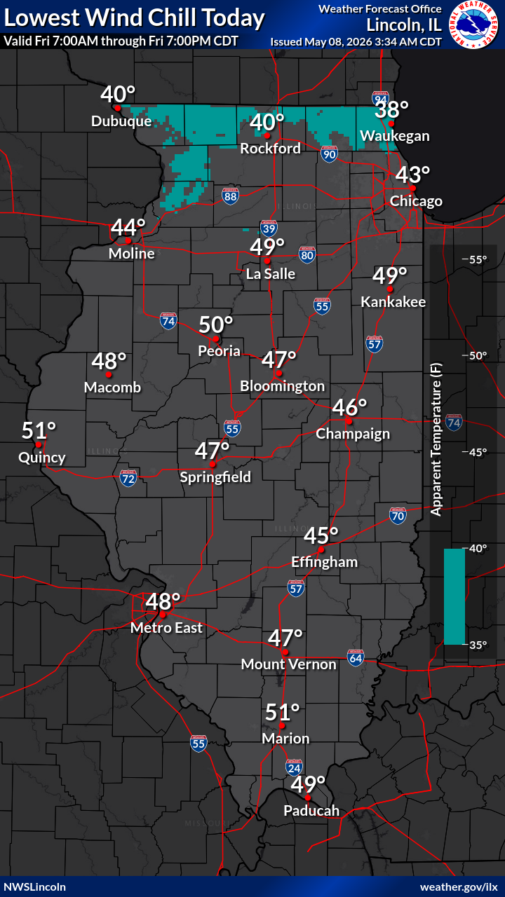
| Day 1 Minimum Temperature | Day 1 Daytime Wind Chill | Day 1 Nighttime Wind Chill | ||
|
 |
 |
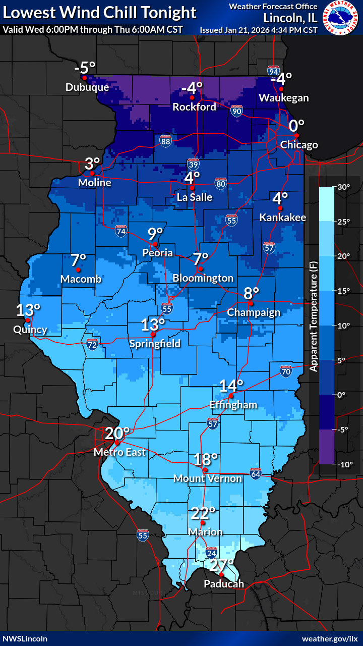
||
| Day 2 Minimum Temperature | Day 2 Daytime Wind Chill | Day 2 Nighttime Wind Chill | ||
 |
 |
|||
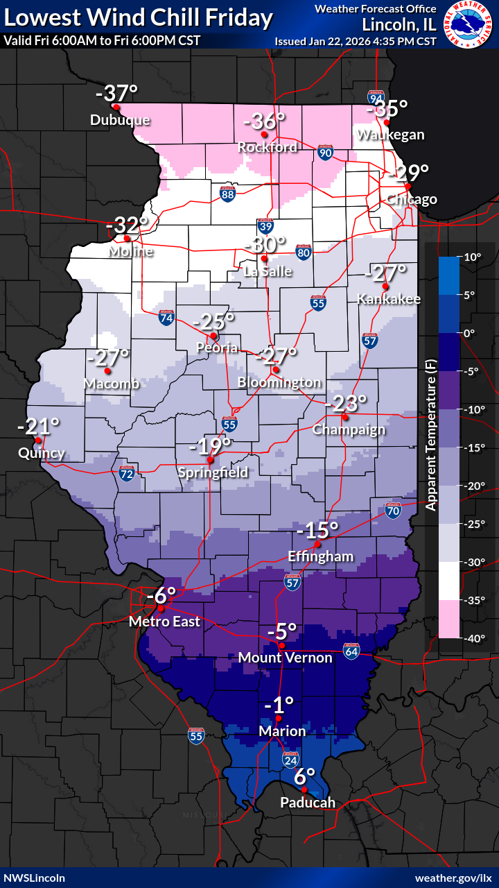
| Day 3 Minimum Temperature | Day 3 Wind Chill | |||
MEDIUM-LONG RANGE COLD OUTLOOKS |
||||
|
|
|
||
| Next Week's Risk of Hazardous Temperatures | 6-10 Day Temperature Outlook | 8-14 Day Temperature Outlook | ||
|
|
|
||
| 3-4 Week Temperature Outlook | One Month Temperature Outlook | Three Month Temperature Outlook | ||

