Overview
|
Thunderstorms moved quickly across central Indiana during the early morning hours of April 19. Some of the storms produced winds over 70 mph, knocking down trees, power poles, and power lines across parts of the area. An 84 mph wind gust was recorded at the Indianapolis International Airport. The main impact was felt from Terre Haute to Clay County and then in the Anderson and Muncie areas. |
Storm Reports
Preliminary Local Storm Report...Summary
National Weather Service Indianapolis IN
916 AM EDT Sat Apr 19 2025

..TIME...   ...EVENT...      ...CITY LOCATION...     ...LAT.LON...
..DATE...   ....MAG....      ..COUNTY LOCATION..ST.. ...SOURCE....
            ..REMARKS..

0447 AM     Tstm Wnd Dmg     Indiana State Universit 39.46N 87.41W
04/19/2025                   Vigo               IN   Broadcast Media

            Thunderstorm winds downed tree branches onto
            a house in Terre Haute. Time estimated from
            radar.

0449 AM     Tstm Wnd Gst     4 ESE Terre Haute       39.44N 87.32W
04/19/2025  M63 MPH          Vigo               IN   ASOS

            Thunderstorm wind gust at KHUF Terre Haute.

0456 AM     Tstm Wnd Dmg     Knightsville            39.53N 87.09W
04/19/2025                   Clay               IN   Broadcast Media

            Thunderstorm winds downed trees at US
            Highway 40 and County Road 100 East causing
            minor structural damage to a 3 car garage.
            Time estimated by radar.

0456 AM     Tstm Wnd Dmg     1 W Brazil              39.52N 87.14W
04/19/2025                   Clay               IN   Amateur Radio

            Thunderstorm winds damaged trees on west
            side of Brazil. Time estimated by radar.

0509 AM     Tstm Wnd Dmg     3 E Putnamville         39.58N 86.81W
04/19/2025                   Putnam             IN   Trained Spotter

            Several pictures from Putnam County of trees
            downed by thunderstorm winds onto cars. Time
            estimated by radar.

0515 AM     Tstm Wnd Gst     1 ESE Greencastle       39.63N 86.81W
04/19/2025  M59 MPH          Putnam             IN   AWOS

            Thunderstorm wind gust at KGPC Greencastle.

0528 AM     Tstm Wnd Dmg     2 S Brownsburg          39.82N 86.40W
04/19/2025                   Hendricks          IN   Trained Spotter

            Thunderstorm winds downed several large
            trees on the south side of Brownsburg
            including at the intersection of Thornburg
            Pkwy and Indiana Route 267. Time estimated
            by radar.

0530 AM     Tstm Wnd Gst     3 E Avon                39.76N 86.34W
04/19/2025  E60 MPH          Hendricks          IN   Amateur Radio

            Ronald Reagan Pkwy and US Highway 36.
0534 AM     Tstm Wnd Gst     1 ENE Indianapolis Int` 39.73N 86.28W
04/19/2025  M84 MPH          Marion             IN   ASOS

            Several planes were moved up to 6 inches at
            Indianapolis International Airport.

0534 AM     Tstm Wnd Dmg     2 WSW Wynnedale         39.83N 86.23W
04/19/2025                   Marion             IN   Public

            Thunderstorm winds uprooted a tree at 38th
            Street and Guion Road. Time estimated by
            radar.

0535 AM     Tstm Wnd Gst     1 ENE Clermont          39.83N 86.30W
04/19/2025  M54 MPH          Marion             IN   ASOS

            Thunderstorm wind gust at KEYE Eagle Creek
            Airpark.

0552 AM     Tstm Wnd Dmg     3 E Noblesville         40.05N 85.97W
04/19/2025                   Hamilton           IN   Public

            Thunderstorm winds downed trees just east of
            Noblesville. Time estimated by radar.

0553 AM     Tstm Wnd Dmg     Pendleton               40.00N 85.74W
04/19/2025                   Madison            IN   Emergency Mngr

            Thunderstorm winds downed multiple power
            lines across southern Madison County and in
            Anderson. Time estimated by radar.

0556 AM     Tstm Wnd Dmg     3 NNE Pendleton         40.04N 85.72W
04/19/2025                   Madison            IN   Emergency Mngr

            Interstate 69 was closed at MM 222 due to
            thunderstorm winds downing lines onto
            roadway. Time estimated by radar.

0611 AM     Tstm Wnd Dmg     Muncie                  40.20N 85.39W
04/19/2025                   Delaware           IN   Broadcast Media

            Thunderstorm winds uprooted a tree into a
            house. Time estimated by radar.

0618 AM     Tstm Wnd Dmg     1 S Albany              40.28N 85.24W
04/19/2025                   Delaware           IN   911 Call Center

            Thunderstorm winds downed trees and or power
            lines south of Albany. Time estimated by
            radar.


&&

$$
Radar
Selected Images Showing High Winds. A loop of the reflectivity is available.
 |
 |
 |
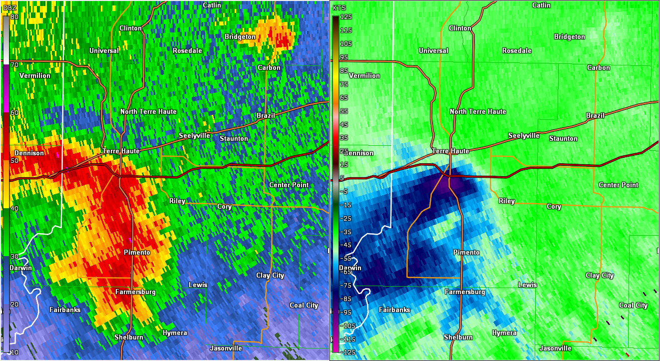
| Radar/Velocity Image near 4:45 AM EDT, near Terre Haute Radar velocity indicated near 110 mph winds at around 4900 ft above ground level. |
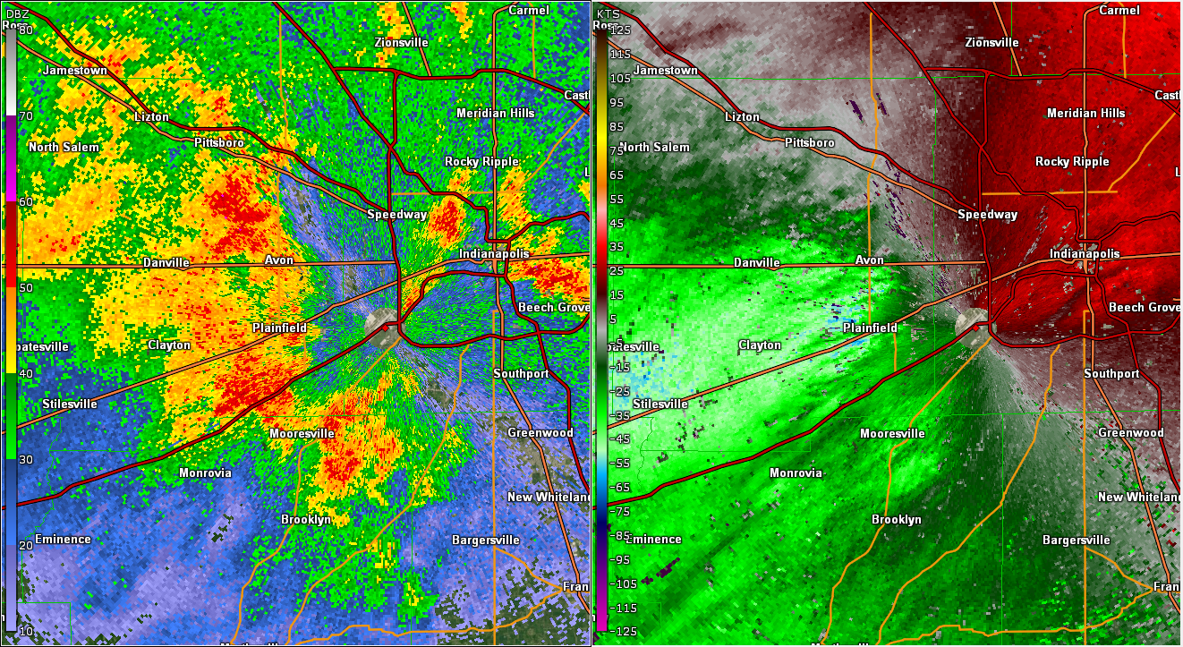
Radar/Velocity Image Near 5:30 AM EDT, near Indy Radar velocity indicated near 90 mph winds at around 360 ft above ground level |
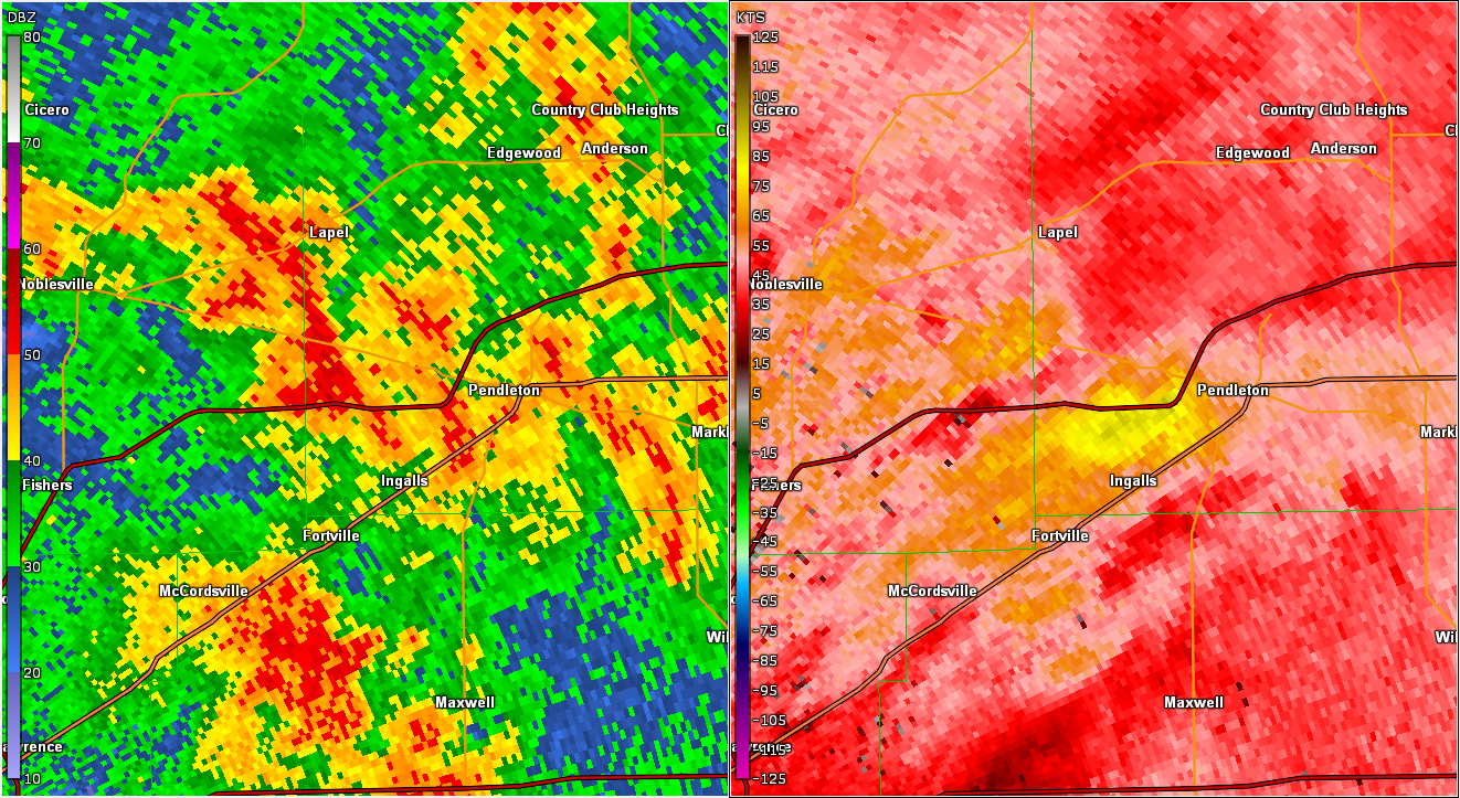
Radar/Velocity Image Near 5:55 AM EDT, near Pendleton Radar velocity indicated near 100 mph winds at around 1900 ft above ground level |
 |
Media use of NWS Web News Stories is encouraged! Please acknowledge the NWS as the source of any news information accessed from this site. |
|

