Blizzard of 1978
Beginning Wednesday January 25, 1978, Indiana was paralyzed by a snow storm that came to be known as the Blizzard of '78, the worst blizzard on record for the Hoosier state.
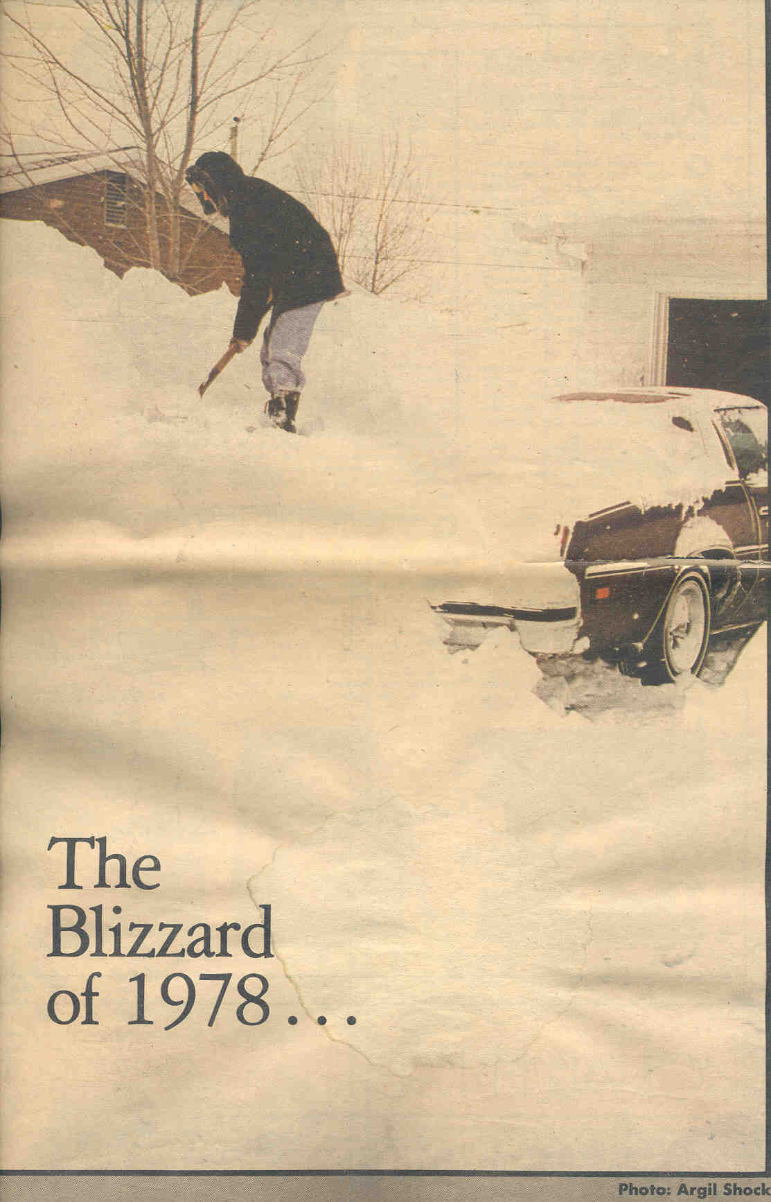
A familiar scene across Indiana during the Blizzard of 78. Photo by Argil Shock and Ft. Wayne News-Sentinal.
Few citizens of central Indiana could have known the devastating impact that this once-in-a-generation blizzard would have on their lives, despite the warnings coming from forecasters at the National Weather Service office in Indianapolis. Even experienced weather professionals, who knew what was coming, had little idea of exactly what they would face over the next few days. The storm set records still in place to this day, including the most snow in one month at Indianapolis, 30.6 inches, and the most snow on the ground at Indianapolis, 20 inches.
Many recall homes buried in snow, close calls with danger on the roadways, or even sledding from second floor windows after the storm finally released Indiana from its grip. One NWS employee who was off duty during the blizzard recalled stuffing newspaper into the cracks around his garage door to keep the howling winds from forcing the snow in through them. Several other NWS employees who were on duty at the time became stranded for up to 74 hours. Some recalled staff members trying everything to get some rest, including sleeping on boxes of teletype paper pushed together.
The human drama extended far beyond the confines of the NWS office at the Indianapolis International Airport. Highways were clogged with stranded motorists. Throughout the Midwest, doctors and emergency personnel were forced to reach people on skis and snowmobiles. The governor sent National Guard tanks onto I-65 to remove stranded semis. A snowbank stalled a seven car Amtrak train in Putnam County. Indiana Bell was forced to halt all phone traffic but emergency calls. In Franklin, the Daily Journal published on pink paper, explaining that the color would help readers find their papers in the snow. The governor declared a snow emergency for the entire state the morning of the 26th. During the afternoon of the 26th, the Indiana State Police considered all Indiana roads closed. Seventy people perished during the storm.
The first ever Blizzard Warning for the entire state of Indiana was issued at 3:45 PM EST on January 25th. A heavy snow warning had been issued 12 hours earlier. Winds would approach 50 mph or more by midnight and continue through the 27th. Temperatures would plummet to a low of zero during the storm, with wind chills approaching -50 on the old wind chill scale. Snowfall rates of nearly one half to as much as one inch per hour were not in and of themselves remarkable, but the duration of the heavy snow was. Significant snowfall lasted about 31 hours at Indianapolis and would be followed by continued cold and high winds. This hampered recovery and relief efforts, leaving much of Indiana crippled for days. In all 15.5 inches of snow would fall at Indianapolis, which combined with the snow already on the ground, would bury the city under 20 inches of snow. In other areas, up to 3 feet of snow fell. The howling winds would push drifts up to as much as 20-25 feet. Visibilities would remain at or below one quarter mile for 25 hours.
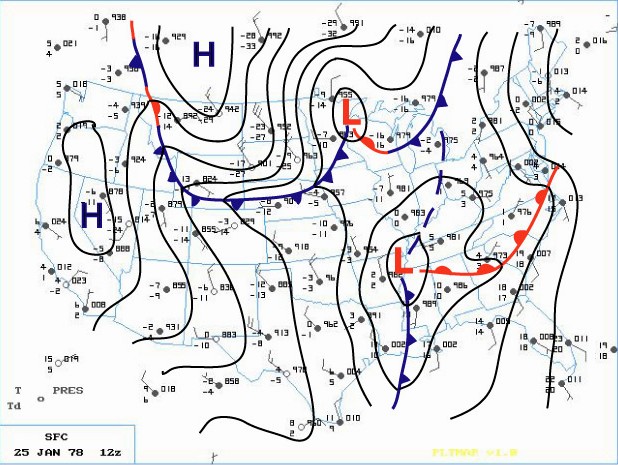
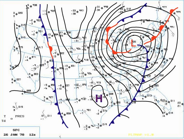
The storm was characterized by a relatively rare merger of two distinct weather systems. The result was a very strong area of low pressure that reached its lowest pressure over Cleveland Ohio.
Below are surface maps from 7:00 AM January 25 and 26. Click an image to enlarge.
 |
 |
Below is a model reanalysis of upper air and surface features valid at 7 AM EST January 26, 1978 (click to enlarge)
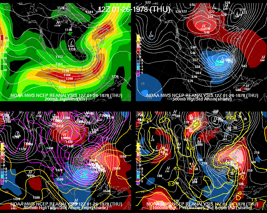
Other images are available: 7 AM January 25 , 7 PM January 25, and 7 PM January 26.
Surface conditions every 3 hours at Indianapolis International Airport during the blizzard of 1978.
| Date, Hour | Visibility (miles) | Weather | Temperature (F) |
Sustained Wind |
Gust Speed (mph) |
| 1/25, 1:00 AM | 2 | Fog | 35 | 7 | |
| 1/25, 4:00 AM | 1/8 | Fog | 34 | 10 | |
| 1/25, 7:00 AM | 1 | Snow, Sleet, Fog | 34 | 9 | |
| 1/25, 10:00 AM | 1 | Sleet, Fog | 34 | 8 | |
| 1/25, 1:00 PM | 1 1/2 | Snow, Fog | 34 | 9 | |
| 1/25, 4:00 PM | 1 | Snow, Sleet, Fog | 32 | 12 | |
| 1/25, 7:00 PM | 3/4 | Snow, Fog | 31 | 14 | |
| 1/25, 10:00 PM | 1/4 | Snow, Fog | 30 | 18 | |
| 1/26, 1:00 AM | 3/16 | Snow, Blowing Snow | 10 | 40 | 48 |
| 1/26, 4:00 AM | 3/16 | Snow, Blowing Snow | 3 | 35 | |
| 1/26, 7:00 AM | 3/16 | Snow, Blowing Snow | 0 | 30 | 44 |
| 1/26, 10:00 AM | 3/16 | Snow, Blowing Snow | 2 | 32 | |
| 1/26, 1:00 PM | 3/16 | Snow, Blowing Snow | 10 | 29 | 39 |
| 1/26, 4:00 PM | 1/8 | Snow, Blowing Snow | 13 | 29 | 44 |
| 1/26, 7:00 PM | 1/4 | Snow, Blowing Snow | 14 | 25 | 38 |
| 1/26, 10:00 PM | 3/8 | Snow, Blowing Snow | 13 | 31 | 44 |
| 1/27, 1:00 AM | 1 | Snow, Blowing Snow | 10 | 25 | 36 |
| 1/27, 4:00 AM | 5 | Blowing Snow | 7 | 20 | |
| 1/27, 7:00 AM | 4 | Blowing Snow | 6 | 17 | 25 |
| 1/27, 10:00 AM | 6 | Blowing Snow | 5 | 17 |
Please Take me back to the NWS Indianapolis Home Page

