Overview
|
Thunderstorms developed near a warm front across central Indiana during the afternoon and evening of February 19. The storms produced damaging winds, large hail, and tornadoes. |
 Radar Images of Bloomington Tornado |
Tornadoes
Select a tornado from the table to zoom into the track and view more information. The default table view is limited to 8 tracks, but can be scrolled by a mouse wheel or dynamically expanded. Additionally, the table can fill the entire window by clicking the small circular expanding arrow icon at the very top right of the table and returned to its original size by clicking the button again. The side information panel that opens over the map can be closed using the "X" on the upper right corner of the pop-up. Zoom into the map and click damage points to see detailed information and pictures from the surveys.
|
NOTE: times shown below are local to your device's time zone. |

The Enhanced Fujita (EF) Scale classifies tornadoes into the following categories:
| EF0 Weak 65-85 mph |
EF1 Moderate 86-110 mph |
EF2 Significant 111-135 mph |
EF3 Severe 136-165 mph |
EF4 Extreme 166-200 mph |
EF5 Catastrophic 200+ mph |
 |
|||||
| Tornadoes that fail to impact any ratable damage indicators on the EF-Scale are rated EF-Unknown (EF-U) | |||||
Storm Reports
A map of storm reports received is below, followed by a text listing of storm reports.

(click for a larger version)
Preliminary Local Storm Report...Summary
National Weather Service Indianapolis IN
120 AM EST Fri Feb 20 2026

..TIME...   ...EVENT...      ...CITY LOCATION...     ...LAT.LON...
..DATE...   ....MAG....      ..COUNTY LOCATION..ST.. ...SOURCE....
            ..REMARKS..

0554 PM     Hail             3 WNW Devore            39.45N 86.81W
02/19/2026  M1.00 Inch       Owen               IN   Public

            Time estimated from radar. Relayed via
            social media.

0612 PM     Hail             Terre Haute             39.47N 87.38W
02/19/2026  E0.25 Inch       Vigo               IN   Amateur Radio

            .

0623 PM     Hail             2 NW Linton             39.06N 87.18W
02/19/2026  M1.25 Inch       Greene             IN   Trained Spotter

            .

0625 PM     Hail             2 SW Monrovia           39.56N 86.51W
02/19/2026  E1.00 Inch       Morgan             IN   Amateur Radio

            Approximate location.

0630 PM     Hail             1 NE Vicksburg          39.10N 87.18W
02/19/2026  E0.50 Inch       Greene             IN   Public

            .

0630 PM     Hail             Linton                  39.04N 87.16W
02/19/2026  E1.50 Inch       Greene             IN   Public

            Delayed report.

0630 PM     Tstm Wnd Dmg     1 N Worthington         39.13N 86.98W
02/19/2026                   Greene             IN   Amateur Radio

            Delayed report. Time approximated by radar.
            Rough location...described as north of
            Worthington. Along US 231, several power
            poles were pushed over and left leaning to
            the east, but were not completely toppled.

0634 PM     Tstm Wnd Dmg     Carlisle                38.96N 87.40W
02/19/2026                   Sullivan           IN   Public

            Large tree down on car.

0635 PM     Hail             2 N Lake Hart           39.59N 86.43W
02/19/2026  E0.75 Inch       Morgan             IN   Public

            Report from mPING: Dime (0.75 in.).

0635 PM     Hail             2 NW Worthington        39.14N 86.99W
02/19/2026  M1.25 Inch       Greene             IN   Public

            Corrects previous hail report from 2 NW
            Worthington. Report from mPING: Half Dollar
            (1.25 in.).

0647 PM     Hail             5 E Freedom             39.19N 86.78W
02/19/2026  M0.50 Inch       Owen               IN   Public

            .

0647 PM     Hail             5 ESE Freedom           39.19N 86.78W
02/19/2026  E0.50 Inch       Owen               IN   Cocorahs

            .

0647 PM     Hail             5 W Greenwood           39.62N 86.20W
02/19/2026  E1.00 Inch       Johnson            IN   Public

            Time estimated from radar. Relayed via
            social media.

0700 PM     Hail             4 W Whitehall           39.15N 86.64W
02/19/2026  M1.00 Inch       Monroe             IN   Public

            Delayed report. Deck was covered with
            quarter inch stones with full one inch
            stones mixed in about 1 to 2 per square
            foot.

0701 PM     Tstm Wnd Gst     3 SW Whitehall          39.15N 86.62W
02/19/2026  M70 MPH          Monroe             IN   ASOS

            Bloomington Monroe County Airport.

0705 PM     Hail             1 SE Bloomington        39.15N 86.51W
02/19/2026  M1.50 Inch       Monroe             IN   Public

            Delayed report. Time estimated from radar.
            Report from mPING: Ping Pong Ball (1.50
            in.).

0705 PM     Tstm Wnd Dmg     2 WSW Whitehall         39.16N 86.61W
02/19/2026                   Monroe             IN   Broadcast Media

            Delayed report. Damage to Monroe County
            Humane Association at 791 S Fieldstone Blvd,
            Bloomington, IN.

0705 PM     Hail             3 SSE Beech Grove       39.68N 86.07W
02/19/2026  E0.50 Inch       Marion             IN   Cocorahs

            .

0706 PM     Hail             4 N Bloomington         39.22N 86.52W
02/19/2026  E0.75 Inch       Monroe             IN   Public

            Up to pea size hail covered the ground.
            Rough approximation of location that was
            described as north of Bloomington. Time
            estimated from radar.

0707 PM     Hail             2 NW Worthington        39.14N 86.99W
02/19/2026  E1.25 Inch       Greene             IN   Public

            Report from mPING: Half Dollar (1.25 in.).

0712 PM     Hail             3 SE Beech Grove        39.68N 86.06W
02/19/2026  M0.75 Inch       Marion             IN   Public

            Report from mPING: Dime (0.75 in.).

0713 PM     Hail             4 E Southport           39.65N 86.04W
02/19/2026  E0.75 Inch       Marion             IN   Public

            Report from mPING: Dime (0.75 in.).

0715 PM     Hail             2 SE Beech Grove        39.70N 86.06W
02/19/2026  E0.25 Inch       Marion             IN   Trained Spotter

            .

0719 PM     Hail             5 W New Palestine       39.71N 85.98W
02/19/2026  E0.75 Inch       Marion             IN   Public

            Report from mPING: Dime (0.75 in.).

0721 PM     Hail             Woodville Hills         39.15N 86.39W
02/19/2026  E1.25 Inch       Monroe             IN   Amateur Radio

            Corrects previous hail report from Woodville
            Hills.

0735 PM     Hail             Greenfield              39.80N 85.77W
02/19/2026  E0.75 Inch       Hancock            IN   Public

            Location...2 blocks south of Hancock
            Regional Hospital.

0742 PM     Hail             4 SE Anderson           40.05N 85.64W
02/19/2026  M1.00 Inch       Madison            IN   Amateur Radio

            .

0744 PM     Hail             2 W Greenfield          39.79N 85.80W
02/19/2026  M0.50 Inch       Hancock            IN   Public

            Report from mPING: Half-inch (0.50 in.).

0745 PM     Hail             Greenfield              39.79N 85.77W
02/19/2026  E1.00 Inch       Hancock            IN   Public

            Time estimated from radar.

0752 PM     Hail             2 SW Clifford           39.25N 85.89W
02/19/2026  M1.00 Inch       Bartholomew        IN   Public

            Report from mPING: Quarter (1.00 in.).

0804 PM     Hail             4 S Yorktown            40.12N 85.48W
02/19/2026  E0.25 Inch       Delaware           IN   Amateur Radio

            .

0817 PM     Tstm Wnd Dmg     Spiceland               39.84N 85.44W
02/19/2026                   Henry              IN   Public

            Large tree downed. Time estimated from
            radar.

0824 PM     Hail             Bloomington             39.17N 86.52W
02/19/2026  E0.25 Inch       Monroe             IN   Amateur Radio

            Trees were blown down...2 foot diameter
            rotten trees at Hickory Grove Apartments
            near Gifford Road and west of Curry Pike.
            Health trees of 1 1/2 to 2 feet in diameter
            were blown down at Highland Village
            Apartments near the same area.
0835 PM     Tornado          3 SSE Adams             39.34N 85.54W
02/19/2026                   Decatur            IN   Trained Spotter

            An EF-U tornado with a path length of 0.92
            miles began at this location. The path width
            was 25 yards. The tornado produced no damage
            and was identified by video footage.
0910 PM     Tstm Wnd Dmg     Sullivan                39.10N 87.42W
02/19/2026                   Sullivan           IN   Trained Spotter

            Several large tree limbs downed across town.
            Time estimated from radar.

0910 PM     Tstm Wnd Dmg     Sullivan                39.10N 87.42W
02/19/2026                   Sullivan           IN   Trained Spotter

            Several large tree limbs downed across town.
            Time estimated from radar.

0940 PM     Rain             1 SW Warren Park        39.77N 86.07W
02/19/2026  M1.94 Inch       Marion             IN   Public

            From late afternoon and evening storms
            today. No flooding issues seen in the area.

1027 PM     Tstm Wnd Gst     1 NW Spurgeons Corner   39.08N 86.16W
02/19/2026  M64 MPH          Brown              IN   Public

            A few tree branches snapped.


&&

$$
Radar
Selected Images from the Event (an overview loop is available)
 |
|
 |
| Radar from 5:54 PM EST (Clockwise from upper left: reflectivity, storm relative velocity, Spectrum Width, Correlation Coefficient) (View a larger image) |
Radar from 7:03 PM EST (Clockwise from upper left: reflectivity, storm relative velocity, Spectrum Width, Correlation Coefficient) (View a larger image) |
Radar from 8:36 PM EST (Clockwise from upper left: reflectivity, storm relative velocity, Spectrum Width, Correlation Coefficient) (View a larger image) |
Environment
A warm front and surface low pressure system brought severe weather to central Indiana. Warm and humid air for February flowed north into the area for the system to interact with.
 |
.gif) |
 |
| Figure 1: 500mb at 6:00 PM EST | Figure 2: 850mb at 6:00 PM EST | Figure 3: Surface Map at 7:00 PM EST |
 |
 |
 |
| Figure 4: Most Unstable CAPE and Effective Shear at 6:00 PM EST | Figure 5: LCL Heights at 6:00 PM EST | Figure 6: Supercell Parameter at 6:00 PM EST |
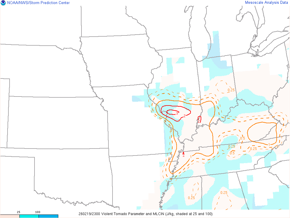 |
| Figure 7: Violent Tornado Parameter at 6:00 PM EST |
Additional Information
The Forecast
 |
 |
 |
|
| SPC Day 4 Outlook | SPC Day 3 Categorical Outlook | SPC Day 2 Categorical Outlook | |
 |
 |
 |
 |
| SPC Day 1 Categorical Outlook | SPC Day 1 Tornado Outlook | SPC Day 1 Hail Outlook | SPC Day 1 Wind Outlook |
 |
Media use of NWS Web News Stories is encouraged! Please acknowledge the NWS as the source of any news information accessed from this site. |
|

