Overview
Numerous severe thunderstorms developed during the afternoon of June 25 across central Indiana. The storms produced tornadoes, damaging winds, and very large hail up to 4 inches in diameter. One person was killed in a tornado with 1 injured by the same tornado in Martin County.Tornadoes
|
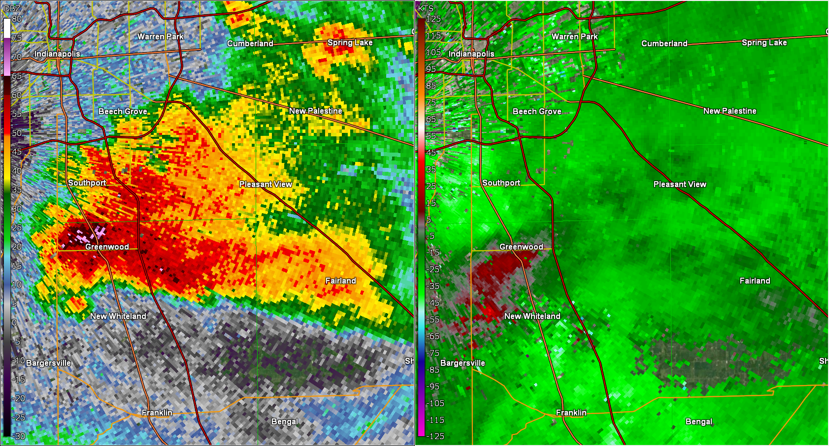
Tornado - Near Bargersville
Track Map 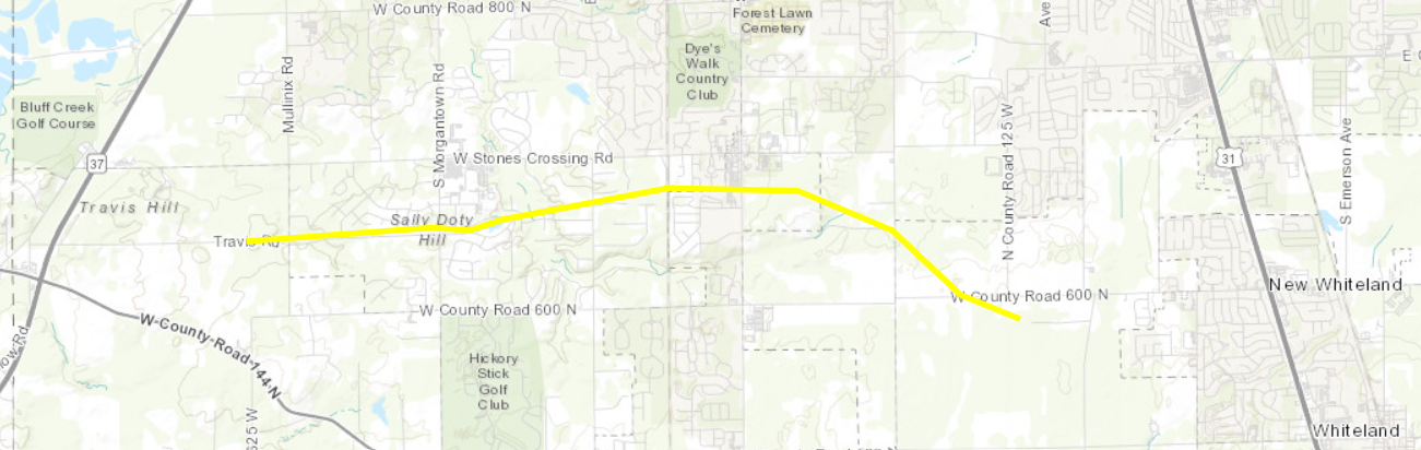 
|
||||||||||||||||
|
||||||||||||||||
|
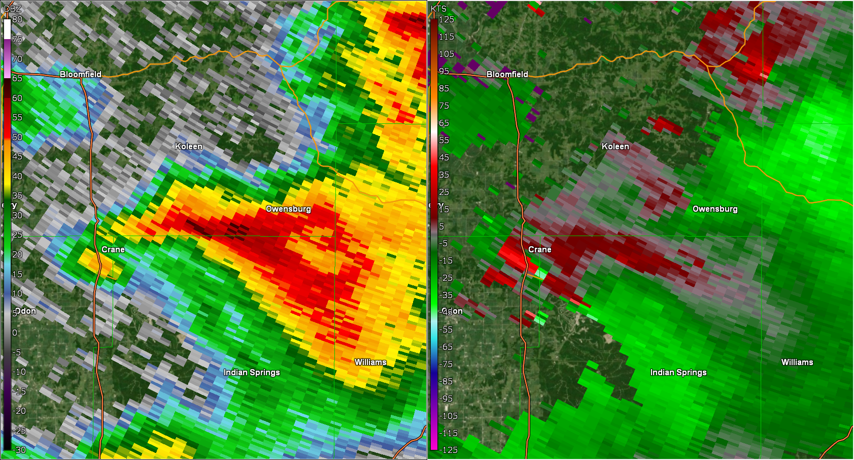
Tornado - Near Crane
Track Map 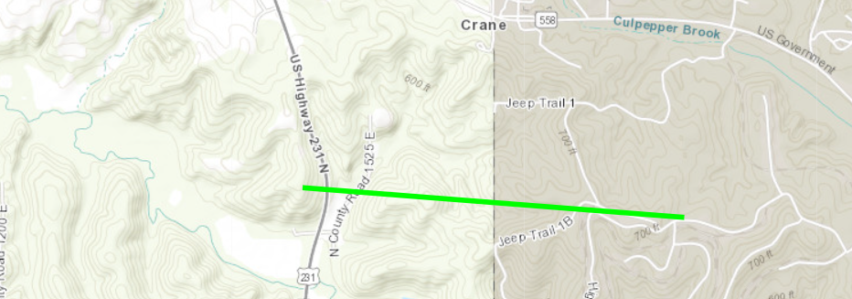
|
||||||||||||||||
|
||||||||||||||||
|
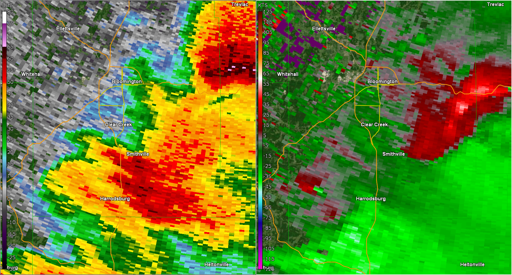
Tornado - NW of Oolitic
Track Map 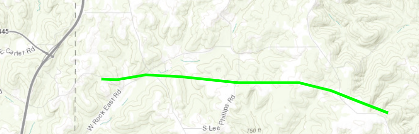
|
||||||||||||||||
|
||||||||||||||||
|
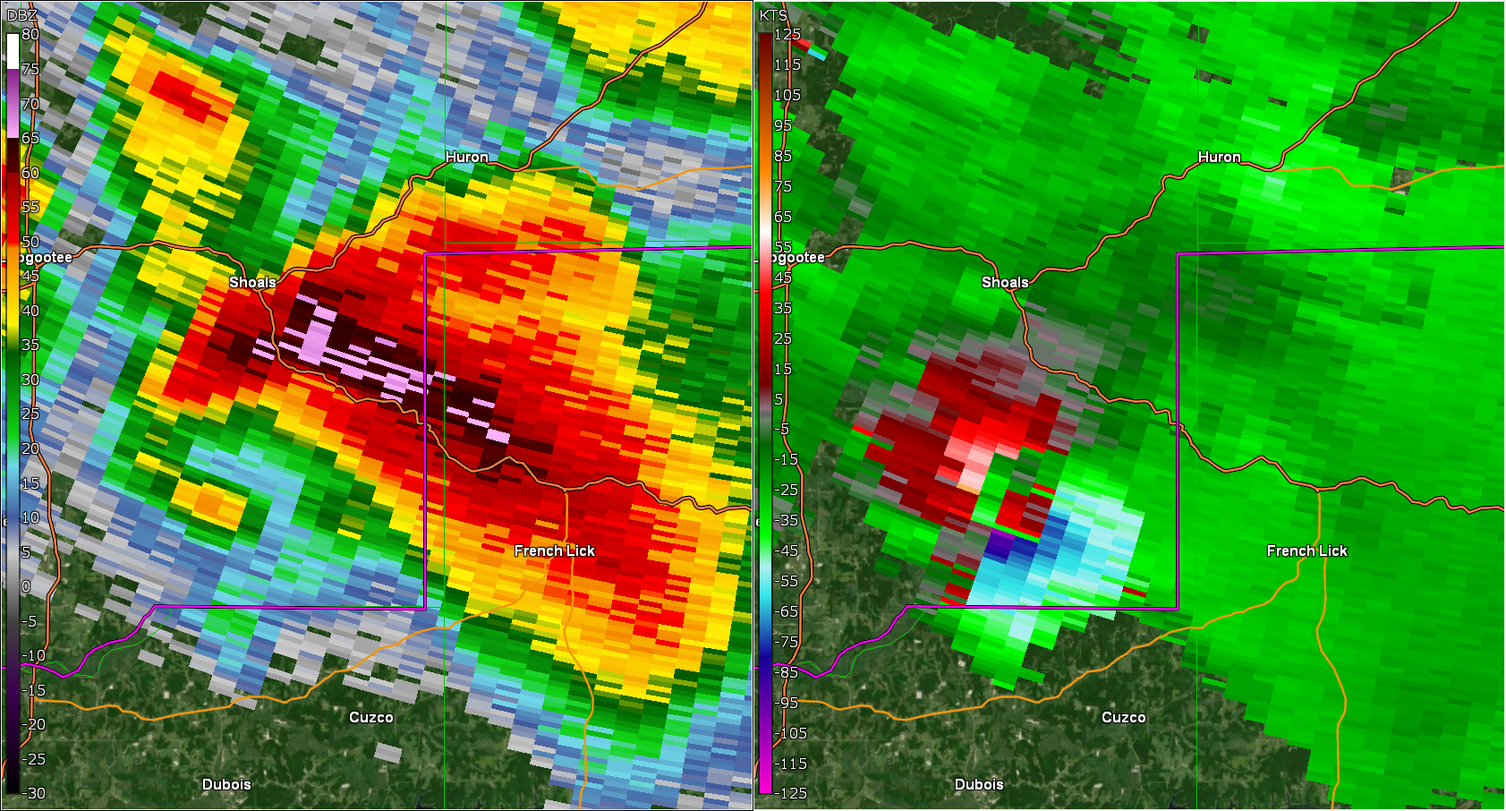
Tornado - Near Alfordsville
Track Map 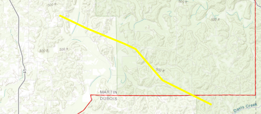
|
||||||||||||||||
|
||||||||||||||||
The Enhanced Fujita (EF) Scale classifies tornadoes into the following categories:
| EF0 Weak 65-85 mph |
EF1 Moderate 86-110 mph |
EF2 Significant 111-135 mph |
EF3 Severe 136-165 mph |
EF4 Extreme 166-200 mph |
EF5 Catastrophic 200+ mph |
 |
|||||
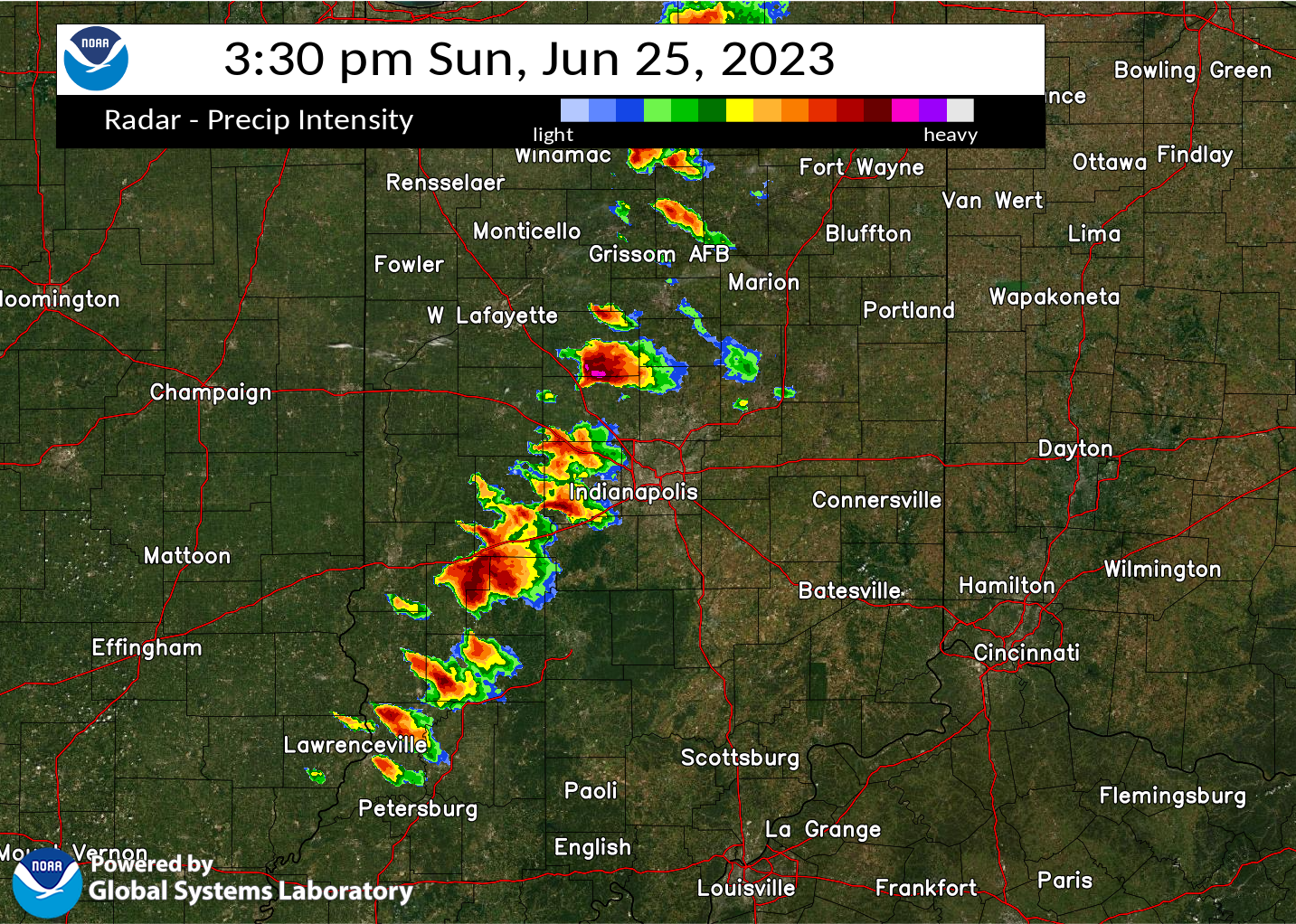
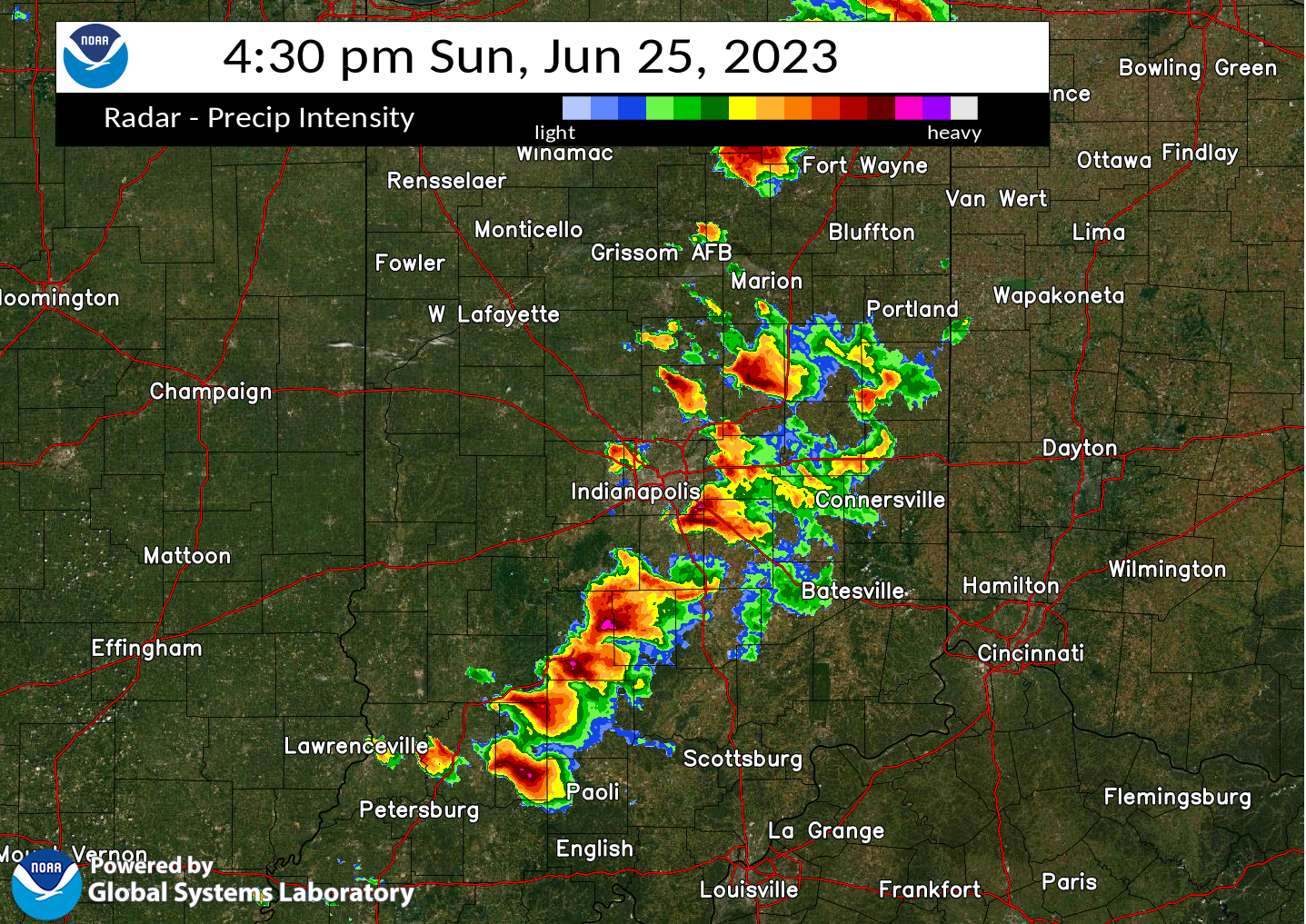
Radar
Selected Images from the Event
 |
 |
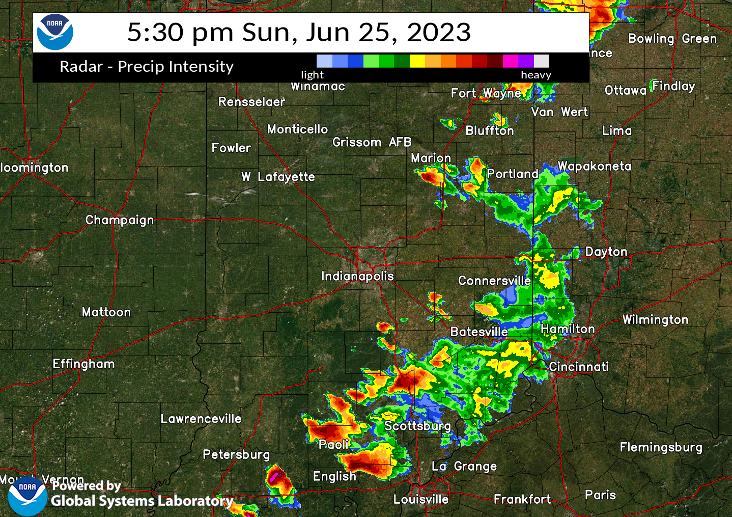 |
| Radar Image at 3:30 PM EDT | Radar Image at 4:30 PM EDT | Radar Image at 5:30 PM EDT |
Storm Reports
Below are reports received by NWS Indianapolis:
Preliminary Local Storm Report...Summary
National Weather Service Indianapolis IN
..TIME... ...EVENT... ...CITY LOCATION... ...LAT.LON...
..DATE... ....MAG.... ..COUNTY LOCATION..ST.. ...SOURCE....
..REMARKS..
0236 PM Tstm Wnd Dmg 2 W Clarks Hill 40.25N 86.76W
06/25/2023 Tippecanoe IN Public
Time and Location are estimated - numerous
tree limbs down.
0304 PM Hail 1 S Colfax 40.18N 86.67W
06/25/2023 E0.75 inch Clinton IN Public
Report from mPING: Dime (0.75 in.).
0305 PM Hail 2 SW Ladoga 39.90N 86.83W
06/25/2023 E0.50 inch Montgomery IN Public
0306 PM Hail 1 NW Greencastle 39.65N 86.86W
06/25/2023 M0.25 inch Putnam IN Emergency Mngr
1/4 inch hail measured on the north side of
Greenastle.
0311 PM Hail Colfax 40.19N 86.67W
06/25/2023 E1.25 inch Clinton IN Public
Delayed report.
0313 PM Hail 3 NW Center Point 39.45N 87.11W
06/25/2023 M2.00 inch Clay IN Public
Delayed report.
0318 PM Hail Kirklin 40.19N 86.36W
06/25/2023 E4.00 inch Clinton IN Public
Size estimated from references used in
social media photos.
0318 PM Hail Kirklin 40.19N 86.36W
06/25/2023 M2.75 inch Clinton IN Public
Damage to roof and siding of home.
0320 PM Hail 1 SSE Frankfort 40.27N 86.50W
06/25/2023 E0.50 inch Clinton IN Public
0325 PM Hail 5 NNE Thorntown 40.19N 86.57W
06/25/2023 E1.50 inch Clinton IN Public
Picture of ping-pong ball sized hail E of
Colfax. Time estimated to be 3:25 pm.
0325 PM Hail 3 W Kirklin 40.20N 86.42W
06/25/2023 E2.00 inch Clinton IN Public
Picture of pool-ball sized hail submitted on
social media by member of public.
0327 PM Hail 1 N Frankfort 40.29N 86.51W
06/25/2023 E0.88 inch Clinton IN Public
0327 PM Hail 1 SW Greencastle 39.63N 86.85W
06/25/2023 E0.25 inch Putnam IN Public
0328 PM Hail 1 E Frankfort 40.28N 86.50W
06/25/2023 E0.50 inch Clinton IN Public
Report from mPING: Half-inch (0.50 in.).
0337 PM Hail Clayton 39.69N 86.52W
06/25/2023 M1.50 inch Hendricks IN Trained Spotter
0345 PM Hail 3 NNW Sheridan 40.17N 86.24W
06/25/2023 E2.50 inch Boone IN Public
Report from mPING: Tennis Ball (2.50 in.).
0345 PM Hail Kempton 40.29N 86.23W
06/25/2023 E0.75 inch Tipton IN Public
Report from mPING: Dime (0.75 in.).
0345 PM Hail 5 WNW Elizaville 40.16N 86.47W
06/25/2023 E2.00 inch Boone IN Public
Public report of 2 inch hail in Kirklin, IN
via social media.
0347 PM Hail 2 NNW Plainfield 39.73N 86.41W
06/25/2023 E1.00 inch Hendricks IN Public
Quarter sized hail reported by member of
public in N Plainfield. Time estimated via
radar.
0347 PM Tstm Wnd Dmg 4 W Sheridan 40.13N 86.29W
06/25/2023 Boone IN Public
Report from mPING: 1-inch tree limbs broken;
Shingles blown off.
0350 PM Hail Washington 38.66N 87.17W
06/25/2023 E0.70 inch Daviess IN Amateur Radio
0352 PM Hail 2 WSW Plainfield 39.68N 86.42W
06/25/2023 E0.50 inch Hendricks IN Public
Report from mPING: Half-inch (0.50 in.).
0353 PM Hail 4 WSW Plainfield 39.68N 86.45W
06/25/2023 E1.00 inch Hendricks IN Public
Report from mPING: Quarter (1.00 in.).
0354 PM Hail 2 WSW Plainfield 39.68N 86.42W
06/25/2023 E1.25 inch Hendricks IN Public
Report from mPING: Half Dollar (1.25 in.).
0355 PM Hail Sheridan 40.13N 86.22W
06/25/2023 E2.50 inch Hamilton IN Public
Report from mPING: Tennis Ball (2.50 in.).
0356 PM Hail Washington 38.66N 87.16W
06/25/2023 E1.00 inch Daviess IN Public
The hail lasted about 5 min.
0359 PM Hail Gosport 39.35N 86.66W
06/25/2023 E1.25 inch Owen IN Public
Report from mPING: Half Dollar (1.25 in.).
0400 PM Tstm Wnd Dmg 1 W Speedway 39.80N 86.26W
06/25/2023 Marion IN Public
Public report of tree damage, blocking
Speedway Drive. Time estimated via radar.
0400 PM Hail 1 WNW Plainfield 39.71N 86.41W
06/25/2023 E0.50 inch Hendricks IN Public
Report from mPING: Half-inch (0.50 in.).
0401 PM Hail 1 W Cicero 40.12N 86.04W
06/25/2023 E0.25 inch Hamilton IN Public
Pea size hail 231st Street and Toll Gate
Road, Hamilton County, 1 mile SW of Cicero.
0405 PM Hail 1 NE Cicero 40.13N 86.01W
06/25/2023 E1.00 inch Hamilton IN Public
Report from mPING: Quarter (1.00 in.).
0405 PM Hail 3 ENE Eagle Creek Reser 39.86N 86.26W
06/25/2023 E0.25 inch Marion IN Public
0405 PM Hail Spencer 39.29N 86.77W
06/25/2023 E2.75 inch Owen IN Public
0406 PM Tstm Wnd Dmg 3 E Washington 38.66N 87.11W
06/25/2023 Daviess IN Public
Pictures of tree damage just off I-69 at the
Loogootee exit. Delayed report, time
estimated via radar.
0406 PM Hail Spencer 39.28N 86.76W
06/25/2023 M4.00 inch Owen IN Public
Delayed report.
0408 PM Hail 1 N Washington 38.67N 87.17W
06/25/2023 E1.00 inch Daviess IN Public
Report from mPING: Quarter (1.00 in.).
0410 PM Hail 1 ENE Ellettsville 39.24N 86.61W
06/25/2023 M1.75 inch Monroe IN Public
Multiple delayed reports via social media of
measured 1.75 inch hail in Ellettsville.
Time estimated via radar.
0410 PM Tornado 2 ENE Waverly 39.57N 86.24W
06/25/2023 Johnson IN Public
Multiple videos on social media of a tornado
on the ground at the intersection of I-69
and SR-144.
0413 PM Hail 3 ENE Oakville 40.10N 85.35W
06/25/2023 E0.25 inch Delaware IN Public
0414 PM Hail 1 SSE Ellettsville 39.22N 86.62W
06/25/2023 E1.00 inch Monroe IN Public
Report from mPING: Quarter (1.00 in.).
0415 PM Tstm Wnd Dmg 4 NNW Bargersville 39.57N 86.19W
06/25/2023 Johnson IN Public
Delayed report via social media. Damage
reported to homes in the Waters Edge
subdivision. Time estimated via radar. *TOR
POSSIBLE*.
0415 PM Tstm Wnd Dmg 4 NNW Bargersville 39.57N 86.20W
06/25/2023 Johnson IN Public
Photos of trees down and roof damage to
homes in neighborhood south of Center Grove
HS near intersection of Morgantown and
Travis Rds. Time estimated via radar. *TOR
POSSIBLE*.
0415 PM Tstm Wnd Dmg 4 ENE Waverly 39.57N 86.21W
06/25/2023 Johnson IN Public
Multiple public reports of damage to
structures and heavily damaged roofs off
Stones Crossing Road in the Kensington Grove
Neighborhood. Time estimated via radar. *TOR
POSSIBLE*.
0415 PM Hail 1 E Ellettsville 39.23N 86.61W
06/25/2023 M2.00 inch Monroe IN Public
0415 PM Hail 2 S Ellettsville 39.20N 86.62W
06/25/2023 E2.50 inch Monroe IN Public
0416 PM Hail 1 SSE Bloomington 39.15N 86.51W
06/25/2023 M1.00 inch Monroe IN Public
0416 PM Hail 1 SSE Ellettsville 39.22N 86.62W
06/25/2023 E1.75 inch Monroe IN Public
Report from mPING: Golf Ball (1.75 in.).
0416 PM Hail 3 S Paragon 39.35N 86.56W
06/25/2023 E1.00 inch Morgan IN Public
0417 PM Hail Ellettsville 39.23N 86.62W
06/25/2023 E0.75 inch Monroe IN Public
Report from mPING: Dime (0.75 in.).
0418 PM Hail 2 SE Ellettsville 39.21N 86.59W
06/25/2023 E1.25 inch Monroe IN Public
Report from mPING: Half Dollar (1.25 in.).
0420 PM Hail 2 NW New Whiteland 39.59N 86.12W
06/25/2023 E1.50 inch Johnson IN Public
Time estimated from radar.
0420 PM Tornado 3 WNW New Whiteland 39.58N 86.16W
06/25/2023 Johnson IN Public
Multiple videos sent in on social media of a
tornado on the ground near Stones Crossing
Road and State Road 135. Time estimated via
radar.
0420 PM Hail 2 SE Greenwood 39.59N 86.09W
06/25/2023 E0.70 inch Johnson IN Public
0420 PM Hail 2 ESE Greenwood 39.60N 86.08W
06/25/2023 E0.50 inch Johnson IN Public
Report from mPING: Half-inch (0.50 in.).
0422 PM Hail 3 E Greenwood 39.61N 86.06W
06/25/2023 E1.25 inch Johnson IN Public
Report from mPING: Half Dollar (1.25 in.).
0424 PM Hail 4 E Southport 39.65N 86.04W
06/25/2023 E0.75 inch Marion IN Public
Report from mPING: Dime (0.75 in.).
0425 PM Hail 1 NNW Loogootee 38.68N 86.92W
06/25/2023 M3.00 inch Martin IN Public
3 inch measured hailstone. Delayed Report.
0427 PM Hail Loogootee 38.67N 86.92W
06/25/2023 E1.50 inch Martin IN Public
Delayed public report of hail in between
quarter and golf ball size in Loogootee via
social media. Time estimated via radar.
0427 PM Hail 2 NNE Southport 39.68N 86.10W
06/25/2023 E1.50 inch Marion IN Public
0430 PM Tstm Wnd Dmg 3 SE Newberry 38.90N 86.97W
06/25/2023 Daviess IN Public
Tornado possible.
0430 PM Hail 6 SW New Palestine 39.67N 85.97W
06/25/2023 E0.50 inch Marion IN Public
0430 PM Hail 5 SW New Palestine 39.68N 85.97W
06/25/2023 E0.50 inch Marion IN Public
Report from mPING: Half-inch (0.50 in.).
0431 PM Hail 7 SW New Palestine 39.65N 85.97W
06/25/2023 E1.00 inch Marion IN Public
Report from mPING: Quarter (1.00 in.).
0433 PM Tornado 2 N New Whiteland 39.59N 86.10W
06/25/2023 Johnson IN Public
Multiple pictures from the public of a
possible tornado near Highway 31 and
Worthsville Road.
0433 PM Tornado Crane 38.90N 86.90W
06/25/2023 Martin IN Law Enforcement
Confirmed tornado, debris visible rotating
on the ground.
0435 PM Tstm Wnd Dmg 2 SW Crane 38.88N 86.92W
06/25/2023 Daviess IN Public
Reports of multiple trees down on homes and
cars. No reports of injuries at this time.
0437 PM Hail 1 E Atlanta 40.22N 86.02W
06/25/2023 E0.50 inch Hamilton IN Public
Report from mPING: Half-inch (0.50 in.).
0438 PM Hail 2 E Woodville Hills 39.15N 86.34W
06/25/2023 E0.50 inch Brown IN Public
Report from mPING: Half-inch (0.50 in.).
0446 PM Hail Shelbyville 39.52N 85.78W
06/25/2023 E0.75 inch Shelby IN Public
0450 PM Hail Daleville 40.12N 85.56W
06/25/2023 E1.25 inch Delaware IN Public
0455 PM Hail 1 WNW Spurgeons Corner 39.07N 86.16W
06/25/2023 E1.25 inch Brown IN Public
Time estimated from radar.
0455 PM Hail Shelbyville 39.52N 85.78W
06/25/2023 E0.25 inch Shelby IN Trained Spotter
0503 PM Hail 1 W Milroy 39.50N 85.49W
06/25/2023 M1.00 inch Rush IN Public
Delayed report.
0510 PM Hail 1 WNW Spurgeons Corner 39.07N 86.16W
06/25/2023 E0.75 inch Brown IN Public
Report from mPING: Dime (0.75 in.).
0511 PM Tstm Wnd Dmg 1 WNW Spurgeons Corner 39.07N 86.16W
06/25/2023 Brown IN Public
Report from mPING: 1-inch tree limbs broken;
Shingles blown off.
0525 PM Tstm Wnd Dmg Cortland 38.97N 85.97W
06/25/2023 Jackson IN Public
Public report of tree damage and barn doors
blown in and off.
0537 PM Hail 2 E Seymour 38.96N 85.84W
06/25/2023 E1.00 inch Jackson IN Public
Report of quarter (1.00 in.) sized hail east
of Seymour.
0545 PM Tstm Wnd Dmg 6 S Hayden 38.89N 85.73W
06/25/2023 Jennings IN Broadcast Media
Relayed report of possible damage in
Jennings county along CR 640 West near
Commiskey. Barn roof blown off and trees
uprooted. Time estimated from radar.
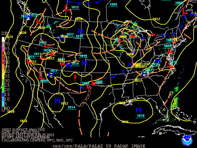
Environment
 |
 |
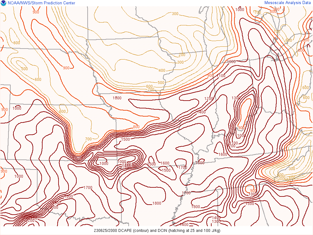 |
| Figure 1: Surface Map at 2:00 PM EDT | Figure 2: Mixed Layer CAPE at 4:00 PM EDT | Figure 3: DCAPE at 4:00 PM EDT |
 |
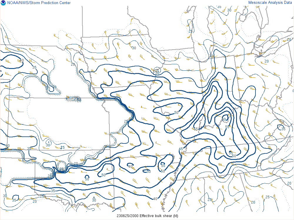 |
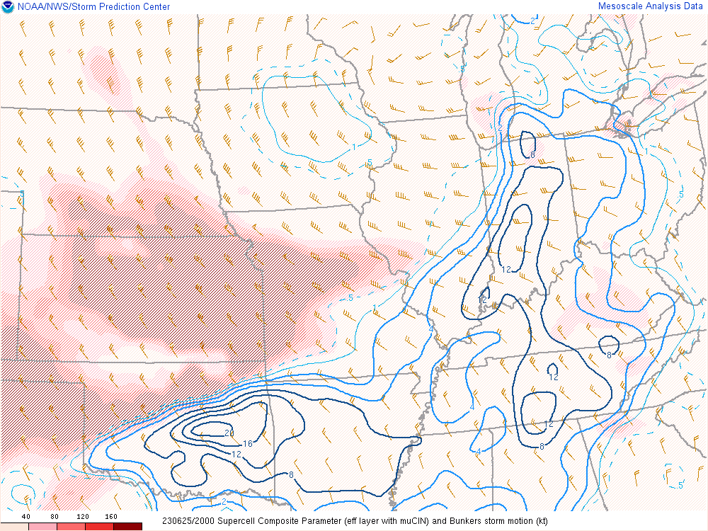
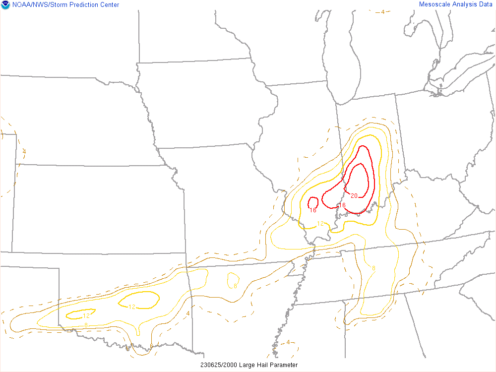 |
| Figure 4: Supercell Composite at 4:00 PM EDT | Figure 5: Effective Shear at 4:00 PM EDT | Figure 6: Large Hail Parameter at 4:00 PM EDT |
 |
Media use of NWS Web News Stories is encouraged! Please acknowledge the NWS as the source of any news information accessed from this site. |
|