Overview
A line of thunderstorms developed across Iowa and then turned into a derecho that moved through central Indiana during the afternoon of June 29. Widespread wind damage occurred, with reports of wind gusts over 70 mph. Numerous power outages occurred, with some areas remaining without power for several days.Radar
Selected Images from the Event
 |
 |
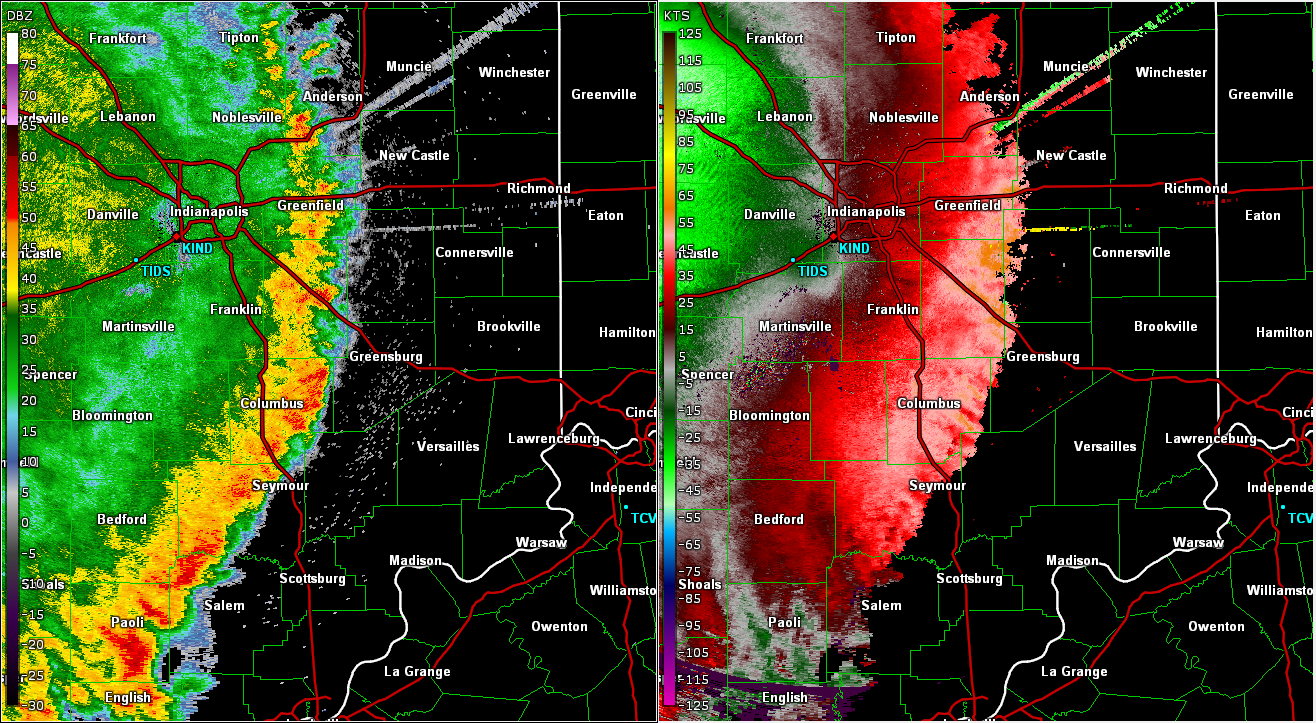 |
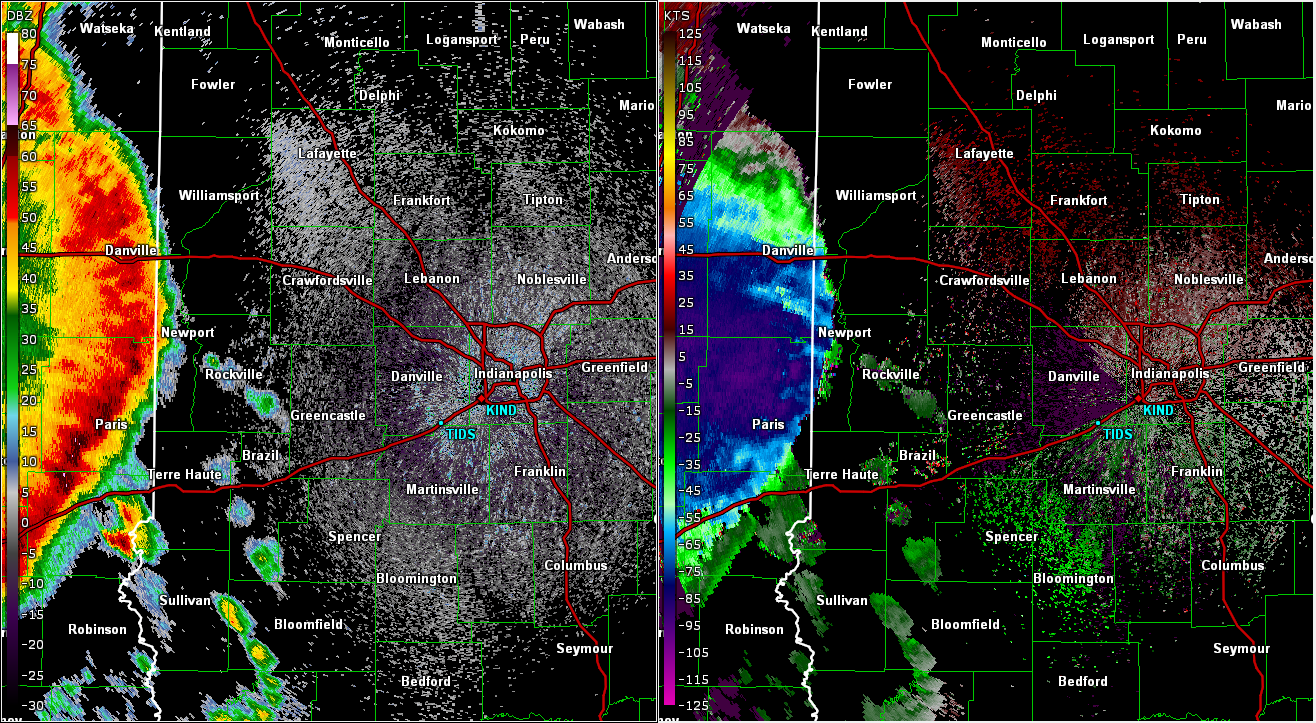
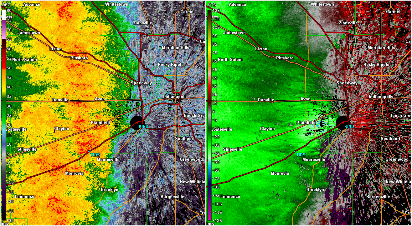
| Radar/Base Velocity Image at 2:46 PM EDT | Zoomed in Radar/Base Velocity Image at 3:41 PMEDT. Radar shows the 70 mph winds that were observed at Indy airport | Radar/Base Velocity Image at 4:20 PM EDT |
Note: The Base Velocity radar image has a special color curve to highlight severe level velocities
Radar Loop of the Event (Link to Video on YouTube):
Storm Reports
Below are reports received by NWS Indianapolis.
Preliminary Local Storm Report...Summary
National Weather Service Indianapolis IN
1027 PM EDT Thu Jun 29 2023

..TIME...   ...EVENT...      ...CITY LOCATION...     ...LAT.LON...
..DATE...   ....MAG....      ..COUNTY LOCATION..ST.. ...SOURCE....
            ..REMARKS..

0619 AM     Hail             1 NNE North Terre Haute 39.55N 87.35W
06/29/2023  E1.00 inch       Vigo               IN   Public

            Report from mPING: Quarter (1.00 in.).

0717 AM     Hail             Sullivan                39.10N 87.41W
06/29/2023  E1.00 inch       Sullivan           IN   Public

            Time estimated via radar.

0743 AM     Tstm Wnd Dmg     1 ENE Vincennes Univers 38.69N 87.51W
06/29/2023                   Knox               IN   Emergency Mngr

            Tree of unknown size or condition downed on
            Niblack Road. Time estimated from radar.

0743 AM     Tstm Wnd Dmg     1 ENE Vincennes Univers 38.69N 87.51W
06/29/2023                   Knox               IN   Emergency Mngr

            Tree of unknown size or condition downed on
            Niblack Road. Time estimated from radar.

0745 AM     Hail             4 SSW Vincennes         38.61N 87.53W
06/29/2023  E1.75 inch       Knox               IN   Emergency Mngr

            Two reports near the same location.

0749 AM     Hail             Worthington             39.12N 86.98W
06/29/2023  E1.00 inch       Greene             IN   911 Call Center

            Relayed to dispatch via social media. Time
            estimated via radar.

1125 AM     Hail             4 N Pimento             39.37N 87.39W
06/29/2023  E1.75 inch       Vigo               IN   Public

            Time estimated from radar.

0252 PM     Tstm Wnd Dmg     Covington               40.14N 87.40W
06/29/2023                   Fountain           IN   Public

            Delayed report of a large tree down on a
            house in Covington. Time estimated via
            radar.

0258 PM     Tstm Wnd Dmg     Kingman                 39.97N 87.28W
06/29/2023                   Fountain           IN   Public

            Tree branches reported down in Kingman. Time
            estimated via radar.

0259 PM     Tstm Wnd Dmg     Veedersburg             40.11N 87.26W
06/29/2023                   Fountain           IN   Public

            Delayed report of a large tree down on a
            house in Veedersburg. Time estimated via
            radar.

0300 PM     Tstm Wnd Dmg     2 NNW Attica            40.31N 87.26W
06/29/2023                   Warren             IN   Public

            Large branches downed and blocking Milligan
            Hill Road. Time estimated via radar.

0300 PM     Tstm Wnd Dmg     2 S Terre Haute         39.44N 87.39W
06/29/2023                   Vigo               IN   Amateur Radio

            Multiple HAM radio operators report
            widespread trees and powerlines down in
            Terre Haute. Estimated 70-80mph winds.

0304 PM     Tstm Wnd Dmg     4 S Attica              40.23N 87.25W
06/29/2023                   Fountain           IN   Public

            Report of multiple trees down in between
            Attica and Veedersburg. Time estimated via
            radar.

0305 PM     Tstm Wnd Dmg     2 N Indiana State Unive 39.50N 87.41W
06/29/2023                   Vigo               IN   Amateur Radio

            Large tree fell onto a house. Powerlines
            also down at 8th and Indiana in Terre Haute.

0305 PM     Tstm Wnd Gst     1 WNW North Terre Haute 39.55N 87.38W
06/29/2023  E65 MPH          Vigo               IN   Public

            65 MPH GUST ESTIMATED AT SKY KING AIRPORT.

0306 PM     Tstm Wnd Dmg     3 N Pimento             39.35N 87.39W
06/29/2023                   Vigo               IN   Public

            Damage to a metal building reported. Photo
            from social media shows walls collapsed and
            roof blown back. Time estimated via radar.

0306 PM     Tstm Wnd Dmg     1 ESE Terre Haute       39.47N 87.37W
06/29/2023                   Vigo               IN   Public

            Large tree down on Ohio Blvd blocking all
            lanes.

0315 PM     Tstm Wnd Dmg     3 NW Center Point       39.44N 87.12W
06/29/2023                   Clay               IN   Trained Spotter

            part of roof ripped from building. Time
            estimated from radar.

0315 PM     Tstm Wnd Gst     2 N New Market          39.98N 86.92W
06/29/2023  M74 MPH          Montgomery         IN   AWOS

            AWOS station KCFJ Crawfordsville.

0316 PM     Tstm Wnd Dmg     3 W Roachdale           39.85N 86.85W
06/29/2023                   Putnam             IN   Public

            Social media report of roof damage to a
            structure and multiple trees down off of
            231. Time estimated via radar.

0320 PM     Tstm Wnd Dmg     2 SSE Groveland         39.73N 86.71W
06/29/2023                   Putnam             IN   Public

            Tree on a dwelling in Heritage Lake, no
            injuries reported. Time estimated via radar.

0320 PM     Tstm Wnd Dmg     1 NW Brazil             39.53N 87.13W
06/29/2023                   Clay               IN   Trained Spotter

            porch collapse and tree on house, trees down
            in the area.

0325 PM     Tstm Wnd Dmg     1 SSE Ladoga            39.91N 86.80W
06/29/2023                   Montgomery         IN   NWS Employee

            Power pole snapped and trees down just south
            of Lagoda. Time estimated via radar.

0326 PM     Tstm Wnd Gst     North Salem             39.86N 86.64W
06/29/2023  M63 MPH          Hendricks          IN   Trained Spotter


0330 PM     Tstm Wnd Dmg     2 WNW Edwardsport       38.83N 87.29W
06/29/2023                   Knox               IN   Emergency Mngr

            Part of roof came off barn. Time estimated
            from radar.

0330 PM     Tstm Wnd Dmg     Greencastle             39.64N 86.84W
06/29/2023                   Putnam             IN   Emergency Mngr

            Power out for half of Greencastle due to
            storms. Numerous trees down. Some barns have
            lost roofs.

0335 PM     Tstm Wnd Dmg     3 NNW New Ross          40.01N 86.73W
06/29/2023                   Montgomery         IN   Trained Spotter

            Large branches down East of 74 on 200 S.

0336 PM     Tstm Wnd Dmg     1 SSW Lafayette         40.39N 86.88W
06/29/2023                   Tippecanoe         IN   Public

            Multiple trees reported down in Lafayette.
            Time estimated via radar.

0340 PM     Tstm Wnd Dmg     1 WNW Plainfield        39.71N 86.41W
06/29/2023                   Hendricks          IN   Public

            Report from mPING: 1-inch tree limbs broken.

0340 PM     Tstm Wnd Dmg     4 SW Zionsville         39.91N 86.33W
06/29/2023                   Marion             IN   Public

            Trees down blocking 86th/1000N on
            Marion/Hendricks County Line.

0341 PM     Tstm Wnd Dmg     3 NW Martinsville       39.46N 86.45W
06/29/2023                   Morgan             IN   Public

            Large tree branches down on Wilbur Road
            north of Martinsville. Time estimated via
            radar.

0342 PM     Tstm Wnd Dmg     Frankfort               40.28N 86.51W
06/29/2023                   Clinton            IN   Public

            Large tree fell on a car, was unoccupied at
            the time. Numerous power lines down across
            Frankfort.

0345 PM     Tstm Wnd Dmg     3 SSE Indianapolis Int` 39.68N 86.27W
06/29/2023                   Marion             IN   Public

            Trees blocking Furnas Road just off S High
            School Road. Time estimated via radar.

0345 PM     Tstm Wnd Dmg     1 SE Indianapolis Int`l 39.71N 86.28W
06/29/2023                   Marion             IN   NWS Employee

            Large tree branch down in the NWS IND
            parking lot.

0345 PM     Tstm Wnd Dmg     3 WNW Advance           40.01N 86.67W
06/29/2023                   Boone              IN   Trained Spotter

            Small tree and large lims down on 200 S in
            West of Lebanon and South of State Road 39.

0345 PM     Tstm Wnd Dmg     Ellettsville            39.23N 86.63W
06/29/2023                   Monroe             IN   Public

            Tree on house. Time estimated from radar.

0347 PM     Tstm Wnd Gst     1 SW Indianapolis Int`l 39.72N 86.30W
06/29/2023  M70 MPH          Marion             IN   ASOS

            ASOS station KIND Indianapolis.

0348 PM     Tstm Wnd Dmg     3 WNW Carmel            39.98N 86.16W
06/29/2023                   Hamilton           IN   Public

            Time estimated. Several medium sized tree
            limbs knocked down.

0348 PM     Tstm Wnd Gst     3 WSW Whitehall         39.15N 86.62W
06/29/2023  M58 MPH          Monroe             IN   ASOS

            ASOS station KBMG Bloomington.

0350 PM     Tstm Wnd Dmg     2 WNW Monument Circle   39.78N 86.20W
06/29/2023                   Marion             IN   Public

            Corrects previous tstm wnd dmg report from 2
            WNW Monument Circle. Multiple large tree
            branches down between 10th and 16th street
            along Belmont Avenue. Time estimated via
            radar.

0350 PM     Tstm Wnd Dmg     2 SSE Bloomington       39.14N 86.51W
06/29/2023                   Monroe             IN   Emergency Mngr

            Several trees and power lines down across
            Monroe County. Duke Energy reports
            widespread outages from the storms. Time
            estimated from radar.

0350 PM     Tstm Wnd Dmg     1 WNW Plainfield        39.71N 86.40W
06/29/2023                   Hendricks          IN   Public

            Report from mPING: Trees uprooted or
            snapped.

0352 PM     Tstm Wnd Dmg     2 ENE Indianapolis      39.79N 86.11W
06/29/2023                   Marion             IN   Public

            Large trees and powerlines down in Brookside
            Park. Time estimated via radar.

0354 PM     Tstm Wnd Dmg     Bargersville            39.52N 86.17W
06/29/2023                   Johnson            IN   Public

            Large tree downed in Bargersville, power
            lines down with it.

0355 PM     Tstm Wnd Dmg     1 SE Rocky Ripple       39.84N 86.16W
06/29/2023                   Marion             IN   Public

            Report from mPING: 3-inch tree limbs broken;
            Power poles broken. Time estimated from
            radar.

0355 PM     Tstm Wnd Gst     6 NNE Zionsville        40.03N 86.25W
06/29/2023  M59 MPH          Boone              IN   AWOS

            AWOS station KTYQ Indianapolis Exc.

0357 PM     Tstm Wnd Dmg     1 SSE North Crows Nest  39.85N 86.15W
06/29/2023                   Marion             IN   Public

            Report from mPING: Trees uprooted or
            snapped.

0358 PM     Tstm Wnd Dmg     2 NNE Fishers           39.99N 86.01W
06/29/2023                   Hamilton           IN   NWS Employee

            Estimated 60 mph squalls. Six inch diameter
            tree downed.

0359 PM     Tstm Wnd Dmg     2 NW Beech Grove        39.73N 86.11W
06/29/2023                   Marion             IN   Public

            Report from mPING: 1-inch tree limbs broken.

0359 PM     Tstm Wnd Dmg     1 WSW Warren Park       39.77N 86.07W
06/29/2023                   Marion             IN   Public

            Report from mPING: 1-inch tree limbs broken.

0400 PM     Tstm Wnd Dmg     1 NW Spring Mill State  38.74N 86.43W
06/29/2023                   Lawrence           IN   Public

            Large tree uprooted along Mill Creek Road in
            Mitchell. Time estimated via radar.

0400 PM     Tstm Wnd Dmg     4 W Greenwood           39.61N 86.20W
06/29/2023                   Johnson            IN   Public

            Numerous large branches down. Time estimated
            from radar.

0402 PM     Tstm Wnd Dmg     1 SSE Monument Circle   39.75N 86.15W
06/29/2023                   Marion             IN   Public

            numerous large branches down across the
            Bates Hendricks neighborhood.

0405 PM     Tstm Wnd Dmg     1 E Bedford             38.86N 86.48W
06/29/2023                   Lawrence           IN   Public

            Fallen tree on car at D/18th Streets. Time
            estimated from radar.

0409 PM     Tstm Wnd Dmg     2 NW Zionsville         39.97N 86.30W
06/29/2023                   Boone              IN   Public

            Report from mPING: 3-inch tree limbs broken;
            Power poles broken.

0409 PM     Tstm Wnd Dmg     4 SW Columbus           39.17N 85.97W
06/29/2023                   Bartholomew        IN   Public

            Report from mPING: 3-inch tree limbs broken;
            Power poles broken.

0410 PM     Tstm Wnd Dmg     1 ENE Rockville         39.77N 87.21W
06/29/2023                   Parke              IN   Emergency Mngr

            Parke County EMA reports damage to several
            buildings. Lots of trees down in roads,
            including 36 and 59.

0415 PM     Tstm Wnd Dmg     6 SSW Columbus          39.14N 85.96W
06/29/2023                   Bartholomew        IN   Public

            Tree down in the right lane of I-65
            southbound near IN-58. Reports of semi
            trucks impacted.

0415 PM     Tstm Wnd Gst     4 SW Columbus           39.17N 85.96W
06/29/2023  M60 MPH          Bartholomew        IN   Trained Spotter

            Corrects previous tstm wnd gst report from 4
            SW Columbus. Measured gust of 60mph.

0417 PM     Tstm Wnd Dmg     2 W Greenfield          39.79N 85.81W
06/29/2023                   Hancock            IN   Public

            Report from mPING: 3-inch tree limbs broken;
            Power poles broken. Time estimated from
            radar.

0418 PM     Tstm Wnd Dmg     1 SW Greenfield         39.79N 85.78W
06/29/2023                   Hancock            IN   Public

            Trees reported down on North Street. Public
            estimates 70mph wind gust.

0420 PM     Tstm Wnd Dmg     1 SW Shelbyville        39.52N 85.78W
06/29/2023                   Shelby             IN   Public

            Report from mPING: Trees uprooted or
            snapped. Time estimated from radar.

0425 PM     Tstm Wnd Dmg     Seymour                 38.96N 85.89W
06/29/2023                   Jackson            IN   Public

            Report on social media of roof damage and a
            collapsed chimney in Seymour. Time estimated
            via radar.

0425 PM     Tstm Wnd Dmg     2 E Saint Paul          39.42N 85.59W
06/29/2023                   Decatur            IN   Emergency Mngr

            Trees and power poles reported down in NW
            Decatur County by EM.

0432 PM     Tstm Wnd Dmg     2 SSW Milroy            39.47N 85.48W
06/29/2023                   Rush               IN   Emergency Mngr

            *** 1 INJ ***
            Tree fell on car with occupants, one person
            injured. Time estimated from radar.
Environment
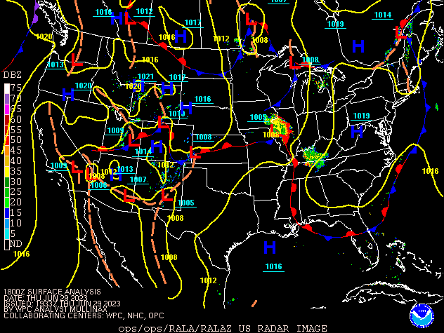
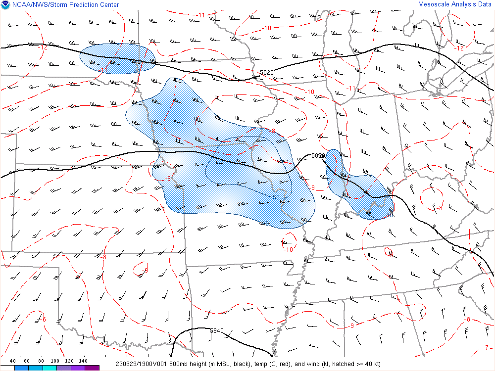
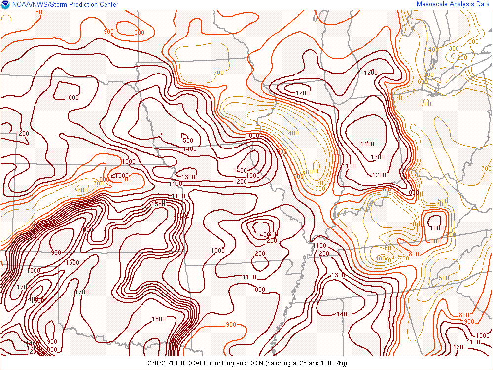
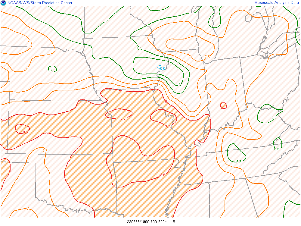
A mid level jet and an influx of unstable air allowed a line of storms to move from Iowa into central Indiana.
 |
 |
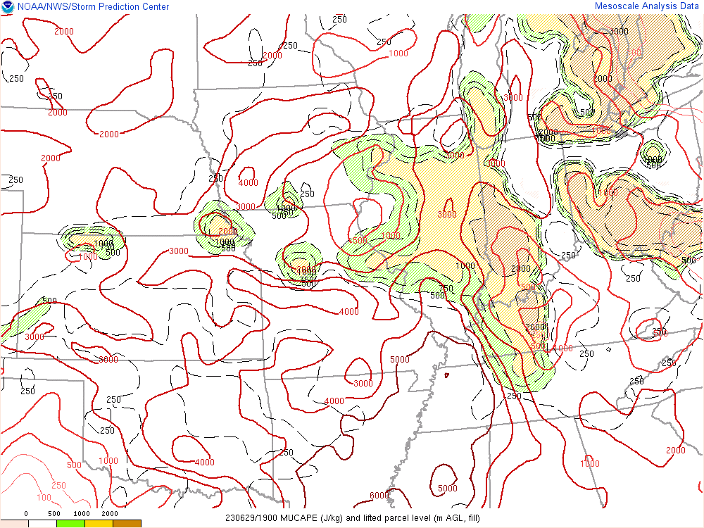 |
| Figure 1: Surface Fronts at 2 PM EDT | Figure 2: 500mb Plot at 3:00 PM EDT | Figure 3: Most Unstable CAPE at 3:00 PM EDT |
 |
 |
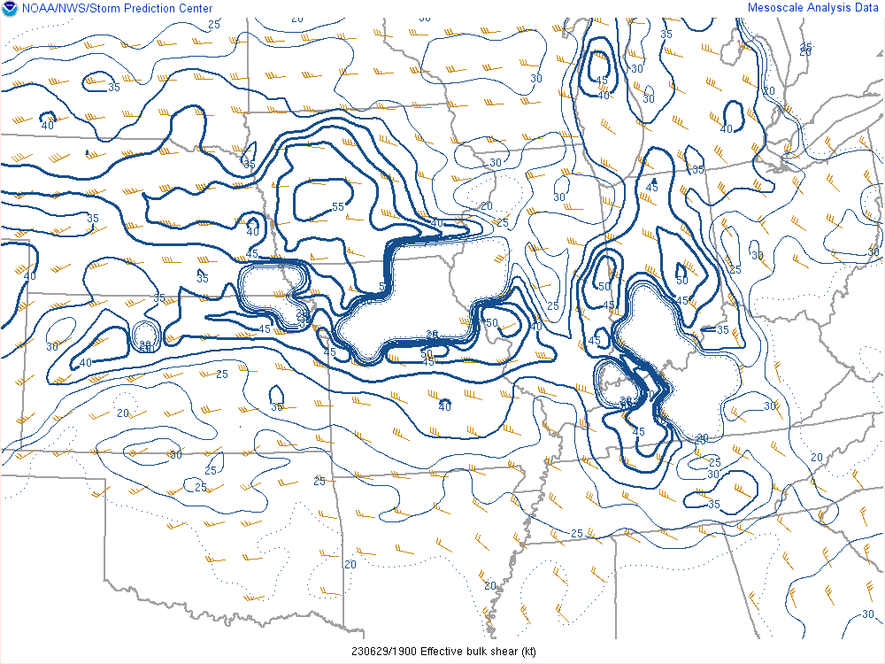 |
| Figure 4: Downdraft CAPE at 3:00 PM EDT | Figure 5: Mid Level Lapse Rates at 3:00 PM EDT | Figure 6: Effective Shear at 3:00 PM EDT |
 |
Media use of NWS Web News Stories is encouraged! Please acknowledge the NWS as the source of any news information accessed from this site. |
|

