Overview
|
A strong low pressure system brought strong non-thunderstorm winds during the day of March 15, then a line of thunderstorms along a cold front brought damaging winds to parts of central Indiana during the evening. |
Storm Reports
Preliminary Local Storm Report...Summary
National Weather Service Indianapolis IN


..TIME...   ...EVENT...      ...CITY LOCATION...     ...LAT.LON...
..DATE...   ....MAG....      ..COUNTY LOCATION..ST.. ...SOURCE....
            ..REMARKS..

0952 PM     Tstm Wnd Dmg     3 W Monroe City         38.62N 87.41W
03/15/2026                   Knox               IN   Law Enforcement

            Tree blown down by thunderstorm winds.

1046 PM     Tstm Wnd Dmg     4 SSW Bedford           38.81N 86.52W
03/15/2026                   Lawrence           IN   Public

            Trees and power lines downed near the
            intersection of US50 and SR 37.

1053 PM     Tstm Wnd Dmg     1 W Unionville          39.23N 86.43W
03/15/2026                   Monroe             IN   Public

            Tree downed near SR 45.

1101 PM     Tstm Wnd Gst     Martinsville            39.42N 86.42W
03/15/2026  M59 MPH          Morgan             IN   Public


1114 PM     Hail             5 NNE Gnaw Bone         39.25N 86.11W
03/15/2026  E0.25 Inch       Brown              IN   Trained Spotter


1115 PM     Tstm Wnd Dmg     2 WSW Franklin          39.48N 86.08W
03/15/2026                   Johnson            IN   Public

            Grill thrown from patio into yard. Fence
            broken. Time estimated by radar.

1116 PM     Tstm Wnd Gst     Indianapolis Int`l Airp 39.72N 86.30W
03/15/2026  M58 MPH          Marion             IN   ASOS


1120 PM     Tstm Wnd Gst     2 WNW Homecroft         39.68N 86.17W
03/15/2026  M71 MPH          Marion             IN   Trained Spotter


1123 PM     Tstm Wnd Gst     1 NW Indianapolis       39.79N 86.16W
03/15/2026  M58 MPH          Marion             IN   Emergency Mngr

1123 PM     Tstm Wnd Dmg     2 N Columbus            39.24N 85.91W
03/15/2026                   Bartholomew        IN   Trained Spotter

            1.5 ft diameter pine tree snapped in half 7
            ft off the ground. Time estimated from radar
            data.

1124 PM     Tstm Wnd Dmg     1 SW Columbus           39.20N 85.92W
03/15/2026                   Bartholomew        IN   Emergency Mngr

            Tree snapped in half.

1125 PM     Tstm Wnd Dmg     3 NW Flat Rock          39.39N 85.87W
03/15/2026                   Shelby             IN   Public

            Tree down.

1137 PM     Tstm Wnd Dmg     3 NNW Morse Reservoir   40.16N 86.09W
03/15/2026                   Hamilton           IN   Fire Dept/Rescue

            Two utility poles were blown down by
            thunderstorm winds near East 256th Street
            and Carson Road. Time estimated from radar.

1142 PM     Tstm Wnd Dmg     1 NNE Lapel             40.08N 85.84W
03/15/2026                   Madison            IN   Emergency Mngr

            Tree across State Road 32.

1142 PM     Tstm Wnd Dmg     Manilla                 39.57N 85.63W
03/15/2026                   Rush               IN   Emergency Mngr

            Power lines downed.

1144 PM     Tstm Wnd Dmg     Arlington               39.61N 85.58W
03/15/2026                   Rush               IN   Emergency Mngr

            Trees and power lines downed. Time estimated
            from radar.

1144 PM     Tstm Wnd Dmg     1 ESE Arlington         39.64N 85.56W
03/15/2026                   Rush               IN   Emergency Mngr

            Multiple trees downed.

1146 PM     Tstm Wnd Dmg     1 ENE Arlington         39.65N 85.55W
03/15/2026                   Rush               IN   Emergency Mngr

            Power lines and trees downed.

1148 PM     Tstm Wnd Dmg     3 NW Rushville          39.64N 85.49W
03/15/2026                   Rush               IN   Emergency Mngr

            Tree down in front of residence into the
            power lines.

1158 PM     Tstm Wnd Dmg     2 N Alexandria          40.29N 85.67W
03/15/2026                   Madison            IN   Public

            Shingles blown off roof. Large tree down.

1206 AM     Tstm Wnd Dmg     2 NW Straughn           39.83N 85.32W
03/16/2026                   Henry              IN   Amateur Radio

            Time estimated from radar.

1215 AM     Tstm Wnd Gst     4 SSE New Castle        39.87N 85.33W
03/16/2026  M51 MPH          Henry              IN   AWOS

            New Castle Henry County Airport...Marlatt
            Field.

1215 AM     Tstm Wnd Gst     2 SW Royerton           40.24N 85.40W
03/16/2026  M54 MPH          Delaware           IN   ASOS

            Measured at KMIE.
Non-Thunderstorm Winds
Below is a listing of peak winds by wind speed. Following that is a list of the speeds sorted by county.
...PEAK *NON-THUNDERSTORM* WIND GUST REPORTS ON MARCH 15, 2026...

COUNTY      Location               Speed    Time/Date    Source

SHELBY      Shelbyville 4 NNW     59 MPH  1238 PM 3/15   ASOS
-----------------------------------------------------------------
MONROE      Bloomington 5 WSW     56 MPH  1211 PM 3/15   ASOS
MONTGOMERY  Crawfordsville 5 S    54 MPH  1255 PM 3/15   AWOS
PUTNAM      Greencastle 3 ESE     54 MPH  1155 AM 3/15   AWOS
BOONE       Zionsville 6 NNE      53 MPH   115 PM 3/15   AWOS
LAWRENCE    Bedford 2 ESE         53 MPH  1223 PM 3/15   AWOS
TIPPECANOE  West Lafayette 2 WSW  53 MPH   325 PM 3/15   ASOS
VIGO        Terre Haute 5 ESE     53 MPH   243 PM 3/15   ASOS
CLINTON     Frankfort 3 WSW       52 MPH   355 PM 3/15   AWOS
MARION      Eagle Creek Airpark   51 MPH   413 PM 3/15   ASOS
HENDRIKCS   Danville 2 ESE        49 MPH   250 PM 3/15   AWOS
HOWARD      Kokomo 5 NE           49 MPH   404 PM 3/15   AWOS
MONTGOMERY  Darlington 2 ENE      49 MPH  1205 PM 3/15   Mesonet
PUTNAM      Greencastle 1 E       49 MPH  1220 PM 3/15   Mesonet
TIPPECANOE  Lafayette 8 S         48 MPH   230 PM 3/15   Mesonet
MADISON     Anderson 3 E          47 MPH   515 PM 3/15   AWOS
BOONE       Whitestown 1.8 SE     46 MPH   330 PM 3/15   Mesonet
HAMILTON    Castleton 1 N         46 MPH   411 PM 3/15   AWOS
DAVIESS     Washington 3 NE       45 MPH  1215 PM 3/15   AWOS
DELAWARE    Wheeling 1 SW         45 MPH   135 PM 3/15   Mesonet
Public Information Statement
National Weather Service Indianapolis IN
655 AM EDT Mon Mar 16 2026

...HIGHEST NON-THUNDERSTORM WIND REPORTS FOR MARCH 15TH...

Location                     Speed     Time/Date       Provider

...Indiana...

...Boone County...
Indianapolis Exc             53 MPH    0115 PM 03/15   AWOS
1.8 SE Whitestown (WEATHERST 46 MPH    0330 PM 03/15   MESOWEST

...Clinton County...
Frankfort                    52 MPH    0355 PM 03/15   AWOS

...Daviess County...
Daviess County Airport       45 MPH    1215 PM 03/15   AWOS

...Delaware County...
Gaston                       45 MPH    0135 PM 03/15   DAVIS

...Hamilton County...
1 N Castleton                46 MPH    0411 PM 03/15   AWOS

...Hendricks County...
2 ESE Danville               49 MPH    0250 PM 03/15   AWOS

...Howard County...
Kokomo                       49 MPH    0404 PM 03/15   AWOS

...Lawrence County...
2 ESE Bedford                53 MPH    1223 PM 03/15   AWOS

...Madison County...
Anderson Municipal Apt       47 MPH    0515 PM 03/15   AWOS

...Marion County...
Indianapolis (Eagle Creek)   51 MPH    0413 PM 03/15   ASOS

...Monroe County...
Bloomington                  56 MPH    1211 PM 03/15   ASOS

...Montgomery County...
Crawfordsville               54 MPH    1255 PM 03/15   AWOS
Darlington                   49 MPH    1205 PM 03/15   DAVIS

...Putnam County...
Greencastle                  54 MPH    1155 AM 03/15   AWOS
Greencastle (WEATHERSTEM)    49 MPH    1220 PM 03/15   MESOWEST

...Shelby County...
Shelbyville                  59 MPH    1238 PM 03/15   ASOS

...Tippecanoe County...
W. Lafayette - Purdue Univ.  53 MPH    0325 PM 03/15   ASOS
Throckmorton Purdue Agricult 48 MPH    0230 PM 03/15   MESOWEST

...Vigo County...
Terre Haute                  53 MPH    0243 PM 03/15   ASOS

Observations are collected from a variety of sources with varying
equipment and exposures. We thank all volunteer weather observers
for their dedication. Not all data listed are considered official.
Environment
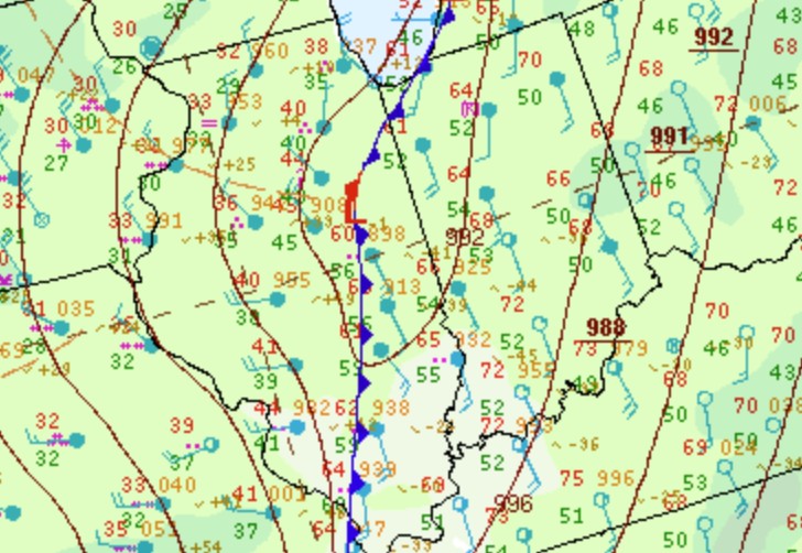
Strong winds mixed down to the surface during the day in the warm sector of the low pressure system.
 |
 |
 |
| Figure 1: Surface Map at 8 PM EDT | Figure 2: 925mb at 12:00 PM EDT | Figure 3: 850mb at 12:00 PM EDT |
Strong shear worked with limited instability to produce an environment for low-end severe weather.
 |
 |
| Figure 4: MLCAPE at 9:00 PM EDT (Image is mislabeled as 00Z instead of 01Z) |
Figure 5: 0-3km shear at 9:00 PM EDT (Image is mislabeled as 00Z instead of 01Z) |
 |
Media use of NWS Web News Stories is encouraged! Please acknowledge the NWS as the source of any news information accessed from this site. |
|

