Overview
The remnants of Hurricane Helene moved into Kentucky, bringing damaging winds to central Indiana on September 27. Power lines were downed, and widespread tree damage occurred. Over 100,000 people without power at one point. For a larger scale overview of wind and rainfall, please see this Storm Summary from the WPC.Wind:
Winds gusted to nearly 70 mph at Indianapolis, with gusts between 40 and 60 mph common across central Indiana.
Public Information Statement
National Weather Service Indianapolis IN
837 AM EDT Sat Sep 28 2024

...HIGHEST WIND REPORTS FROM HELENE REMNANTS...

Location                     Speed     Time/Date       Provider
Indianapolis                 68 MPH    0656 PM 09/27   ASOS
Columbus Balkalar            58 MPH    0445 PM 09/27   AWOS
Indianapolis (Eagle Creek)   55 MPH    0640 PM 09/27   ASOS
Indianapolis Reg             54 MPH    0624 PM 09/27   AWOS
Terre Haute                  53 MPH    0833 PM 09/27   ASOS
Muncie                       53 MPH    0738 PM 09/27   ASOS
Frankfort                    52 MPH    0715 PM 09/27   AWOS
Shelbyville                  49 MPH    0524 PM 09/27   ASOS
Bellmore                     48 MPH    0718 PM 09/27   CWOP
Bloomington                  48 MPH    0602 PM 09/27   ASOS
Greencastle                  48 MPH    0755 PM 09/27   AWOS
Indianapolis Exc             48 MPH    0715 PM 09/27   AWOS
BROWNSBURG                   47 MPH    0800 PM 09/27   CWOP
1.8 SE Whitestown (WEATHERST 46 MPH    0740 PM 09/27   MESOWEST
NEW PALESTINE                46 MPH    0545 PM 09/27   CWOP
Anderson Municipal Apt       46 MPH    0655 PM 09/27   AWOS

Observations are collected from a variety of sources with varying
equipment and exposures. We thank all volunteer weather observers
for their dedication. Not all data listed are considered official.
Radar
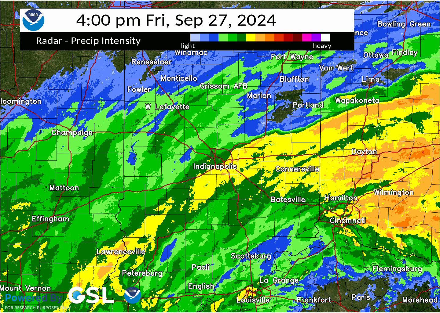
Below are a snapshot of radar velocity near the peak wind at Indianapolis, a loop of radar for central Indiana during the time of peak winds, and a radar overview of Helene:
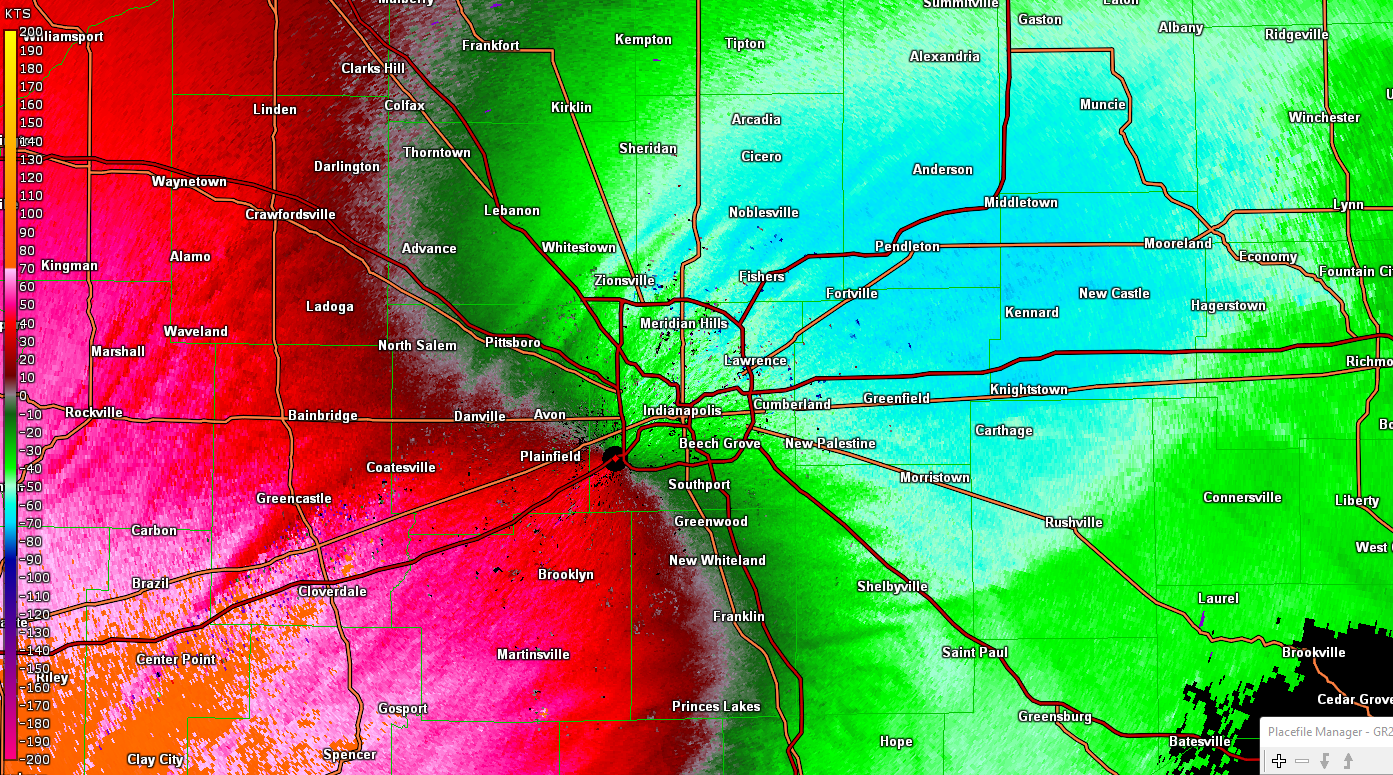 |
| Velocity at 6:54 PM EDT |
Storm Reports
Preliminary Local Storm Report...Summary
National Weather Service Indianapolis IN
432 AM EDT Sat Sep 28 2024

..TIME...   ...EVENT...      ...CITY LOCATION...     ...LAT.LON...
..DATE...   ....MAG....      ..COUNTY LOCATION..ST.. ...SOURCE....
            ..REMARKS..

0833 PM     Non-Tstm Wnd Gst 4 SSW Seelyville        39.45N 87.30W
09/27/2024  M53 MPH          Vigo               IN   ASOS

            ASOS station KHUF Terre Haute.

0951 PM     Non-Tstm Wnd Gst 1 SW Purdue University  40.42N 86.93W
09/27/2024  M44 MPH          Tippecanoe         IN   ASOS

            ASOS station KLAF W. Lafayette - Purdue
            Univ. Arpt.

0524 PM     Non-Tstm Wnd Gst 3 ESE Fairland          39.58N 85.80W
09/27/2024  M49 MPH          Shelby             IN   ASOS

            ASOS station KGEZ Shelbyville.

0545 PM     Non-Tstm Wnd Gst 2 SSE New Palestine     39.70N 85.88W
09/27/2024  M46 MPH          Shelby             IN   Mesonet

            Mesonet station AV182 NEW PALESTINE.

0705 PM     Non-Tstm Wnd Gst 3 E Edinburgh           39.36N 85.91W
09/27/2024  M44 MPH          Shelby             IN   Mesonet

            Mesonet station EW1771 Edinburgh.

0650 PM     Non-Tstm Wnd Dmg Winchester              40.17N 84.98W
09/27/2024                   Randolph           IN   Public

            Large tree branches snapped.

0755 PM     Non-Tstm Wnd Gst 1 ESE Greencastle       39.63N 86.82W
09/27/2024  M48 MPH          Putnam             IN   AWOS

            AWOS station KGPC Greencastle.

0718 PM     Non-Tstm Wnd Gst 3 W Cecil Harden Lake   39.75N 87.10W
09/27/2024  M48 MPH          Parke              IN   Mesonet

            Mesonet station GW2509 Bellmore.

0700 PM     Non-Tstm Wnd Dmg 1 NW Martinsville       39.43N 86.43W
09/27/2024                   Morgan             IN   Public

            Many trees and powerlines reported down
            across Morgan county. Time estimated from
            observations.

0602 PM     Non-Tstm Wnd Gst 3 WSW Whitehall         39.15N 86.62W
09/27/2024  M48 MPH          Monroe             IN   ASOS

            ASOS station KBMG Bloomington.

0635 PM     Non-Tstm Wnd Dmg 1 W Wynnedale           39.83N 86.22W
09/27/2024                   Marion             IN   Public

            Social media picture shared of large tree
            limb snapped and fallen on top of a house.

0640 PM     Non-Tstm Wnd Gst 1 SSE Eagle Creek Reser 39.83N 86.30W
09/27/2024  M55 MPH          Marion             IN   ASOS

            ASOS station KEYE Indianapolis (Eagle
            Creek).

0644 PM     Non-Tstm Wnd Gst Indianapolis Int`l Airp 39.72N 86.30W
09/27/2024  M61 MPH          Marion             IN   Public

            ASOS site reported 61 mph wind gust.

0656 PM     Non-Tstm Wnd Gst 1 SW Indianapolis Int`l 39.72N 86.30W
09/27/2024  M68 MPH          Marion             IN   ASOS

            ASOS station KIND Indianapolis.

0658 PM     Non-Tstm Wnd Dmg 1 SSW Broad Ripple      39.86N 86.13W
09/27/2024                   Marion             IN   Public

            Photo of large tree snapped shared on social
            media. Approximately 2ft in diameter. Time
            estimated from wind observations.

0700 PM     Non-Tstm Wnd Dmg Speedway                39.79N 86.25W
09/27/2024                   Marion             IN   Public

            Large tree limb in road.

0722 PM     Non-Tstm Wnd Dmg 2 NE Broad Ripple       39.88N 86.10W
09/27/2024                   Marion             IN   Public

            Report from mPING: 3-inch tree limbs broken;
            Power poles broken.

0730 PM     Non-Tstm Wnd Dmg 2 SW Indiana State Fair 39.81N 86.15W
09/27/2024                   Marion             IN   Broadcast Media

            Large tree snapped at a residence on N
            Washington Blvd, blocking part of the
            street.

0750 PM     Non-Tstm Wnd Dmg 1 SSW Broad Ripple      39.86N 86.13W
09/27/2024                   Marion             IN   Amateur Radio

            Large tree downed on Rosslyn Ave.

0650 PM     Non-Tstm Wnd Dmg 2 N Country Club Height 40.15N 85.69W
09/27/2024                   Madison            IN   Public

            Social media picture shared of large tree
            branches down. Time estimated from
            observations.

0655 PM     Non-Tstm Wnd Gst 1 WNW Chesterfield      40.12N 85.62W
09/27/2024  M46 MPH          Madison            IN   AWOS

            AWOS station KAID Anderson Municipal Apt.

0800 PM     Non-Tstm Wnd Dmg Vincennes               38.69N 87.51W
09/27/2024                   Knox               IN   Emergency Mngr

            Numerous trees and utility lines down across
            Knox County.

0605 PM     Tstm Wnd Dmg     3 NW Trafalgar          39.44N 86.18W
09/27/2024                   Johnson            IN   Public

            Report from mPING: 1-inch tree limbs broken;
            Shingles blown off.

0540 PM     Non-Tstm Wnd Dmg Seymour                 38.96N 85.89W
09/27/2024                   Jackson            IN   Public

            Large branches downed.

0651 PM     Non-Tstm Wnd Gst 3 ESE Danville          39.75N 86.47W
09/27/2024  M44 MPH          Hendricks          IN   AWOS

            AWOS station K2R2 2 ESE Danville.

0800 PM     Non-Tstm Wnd Gst 2 NW Brownsburg         39.86N 86.42W
09/27/2024  M47 MPH          Hendricks          IN   Mesonet

            Mesonet station GW4766 BROWNSBURG.

0624 PM     Non-Tstm Wnd Gst 4 SSE Mccordsville      39.85N 85.90W
09/27/2024  M54 MPH          Hancock            IN   AWOS

            AWOS station KMQJ Indianapolis Reg.

0640 PM     Non-Tstm Wnd Dmg 1 N Greenfield          39.80N 85.77W
09/27/2024                   Hancock            IN   Public

            Social media report of tree down on
            powerlines. Time estimated from
            observations.

0640 PM     Non-Tstm Wnd Gst 2 NNW Mccordsville      39.93N 85.95W
09/27/2024  E65 MPH          Hamilton           IN   Trained Spotter

            Healthy tree limbs down. Time estimated from
            observations.

0714 PM     Non-Tstm Wnd Gst 2 N Castleton           39.93N 86.05W
09/27/2024  M43 MPH          Hamilton           IN   AWOS

            AWOS station KUMP 1 N Castleton.

0650 PM     Non-Tstm Wnd Dmg Muncie                  40.20N 85.39W
09/27/2024                   Delaware           IN   Public

            Social media picture shared of large tree
            limbs and powerlines snapped. Time estimated
            from observations.

0704 PM     Non-Tstm Wnd Dmg 1 S Ball State Universi 40.18N 85.41W
09/27/2024                   Delaware           IN   Public

            Report from mPING: 3-inch tree limbs broken;
            Power poles broken.

0738 PM     Non-Tstm Wnd Gst 3 NNE Ball State Univer 40.23N 85.40W
09/27/2024  M53 MPH          Delaware           IN   ASOS

            ASOS station KMIE Muncie.

0715 PM     Non-Tstm Wnd Gst 3 WSW Frankfort         40.27N 86.57W
09/27/2024  M52 MPH          Clinton            IN   AWOS

            AWOS station KFKR Frankfort.

0635 AM     Non-Tstm Wnd Gst 1 N Nashville           39.21N 86.24W
09/27/2024  M52 MPH          Brown              IN   Public


0539 PM     Non-Tstm Wnd Dmg 1 W Spurgeons Corner    39.07N 86.16W
09/27/2024                   Brown              IN   Public

            Tree branches down.

0715 PM     Non-Tstm Wnd Gst 6 NNE Zionsville        40.03N 86.25W
09/27/2024  M48 MPH          Boone              IN   AWOS

            AWOS station KTYQ Indianapolis Exc.

0740 PM     Non-Tstm Wnd Gst 2 ESE Whitestown        39.98N 86.32W
09/27/2024  M46 MPH          Boone              IN   Mesonet

            Mesonet station 1321W 1.8 SE Whitestown
            (WEATHERSTEM).

0445 PM     Non-Tstm Wnd Gst 2 SW Clifford           39.27N 85.90W
09/27/2024  M58 MPH          Bartholomew        IN   AWOS

            AWOS station KBAK Columbus Balkala.

0550 PM     Non-Tstm Wnd Dmg Columbus                39.21N 85.91W
09/27/2024                   Bartholomew        IN   Law Enforcement

            Multiple trees reported down.
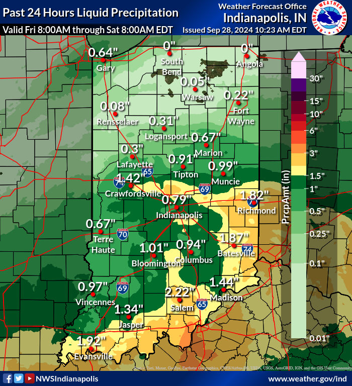
Rainfall
Environment
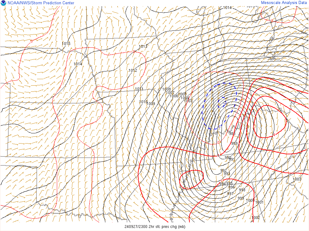
Hurricane Helene moved quickly north and became an extratropical low pressure system, which then moved into the Ohio Valley.
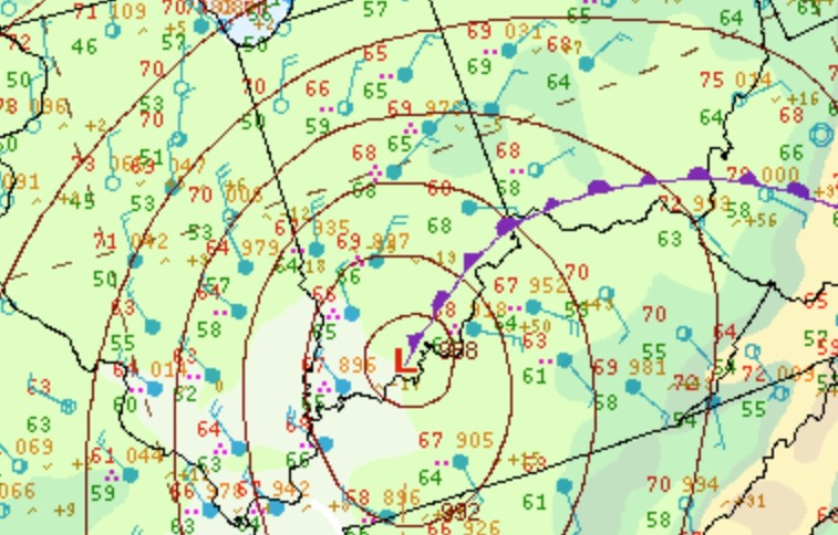 |
 |
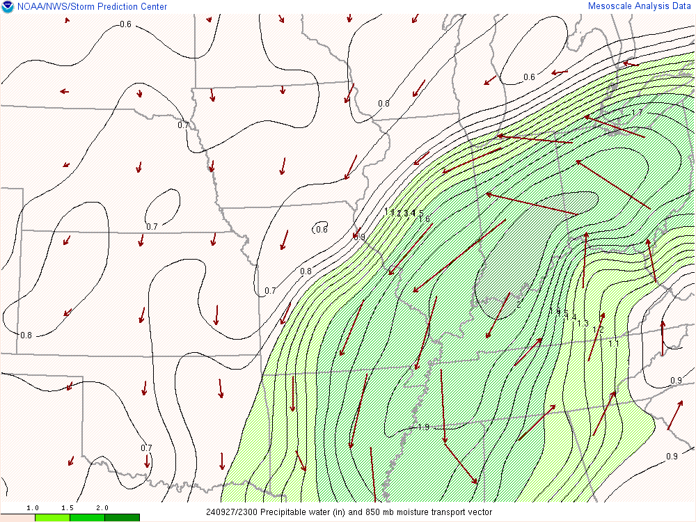 |
| Figure 1: Zoomed Surface Map at 8 PM EDT | Figure 2: Surface Pressure and 2 Hour Pressure Change at 7 PM EDT | Figure 3: Precipitable Water and Moisture Transport at 7 PM EDT |
 |
Media use of NWS Web News Stories is encouraged! Please acknowledge the NWS as the source of any news information accessed from this site. |
|

