A significant heavy rain and flash flooding event occurred on October 16 and into the first part of October 17. The event was set up by an anomalous pool of tropical type moisture (~300% of normal) over the western Gulf of America which was then pulled northward by strong low level winds in advance of a westward moving upper level disturbance. There were several other factors in play which contributed to the large amounts of rain, such as a northward moving warm front and a building upper ridge over the eastern Gulf of America. The warm front helped lift the air while the building upper ridge served to weaken the westward moving upper disturbance. This then caused the progression of the heavy convective rains to slow and dump tremendous amounts of rain from southeast Texas to north and central Louisiana and then into west-central Mississippi. By late evening, dry mid level air began pushing east from Texas and allowed the heavy rain shield to move and exit the region by early Tuesday morning.
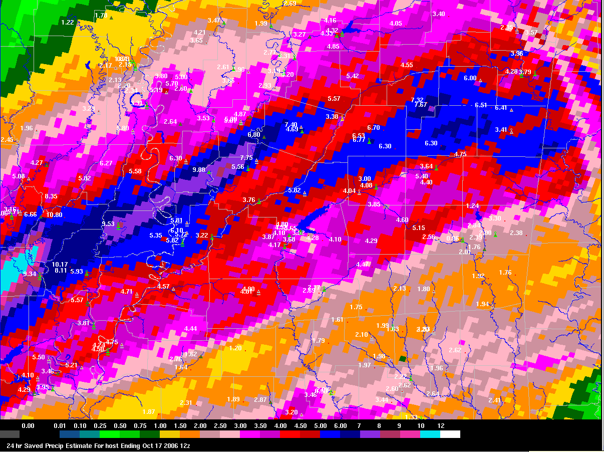
What makes this event rare is that such a large area received 6 to 10 inches of rain and an even larger area received 4 to 6 inches. Embedded in that swath, a few locations in northern and central Louisiana received a whopping 12 to 17 inches! During this time of year, these kinds of rains usually occur from slow moving tropical cyclones, not from a warm front and westward moving upper disturbance. The result of all this rain was numerous reports of flash flooding, some even significant, across northeast Louisiana and west-central Mississippi. This event will go down in the record books for the amount of real estate covered by heavy rainfall and the several locations that measured extreme amounts.
The heavy rain wasn't the only story, scattered reports of severe weather also occurred across the area. A couple of tornadoes have been confirmed along with some wind damage. An F1 tornado occurred in Thornton in Holmes County, Mississippi. An F2 tornado occurred in the Oak Grove community just west of Hattiesburg in Lamar County, Mississippi, damaging several homes. Most of the wind damage was in the form of trees and power lines down as small "bow echo" segments moved northeast within the band of heavy rain. In Lake Village, Arkansas, strong pressure gradient winds caused numerous trees to be blown down as well as minor roof damage to some structures. In addition, a large bow echo moved across south Mississippi early in the morning on October 17, 2006. The complex produced an F2 tornado in the community of Oak Grove in northeast Lamar County. Nine homes were damaged by the short track tornado, 2 with major damage and 7 with minor damage. Large portions of roof were torn from 2 homes. Portions of deck awning and metal barn roofing were blown one half to one mile away. Missiles were generated by the tornado, including wooden posts that were wedged into a lawn and a plywood sheet that peeled sod from a section of a lawn. A large sheet of plywood was propelled into a tree which carved a slot into the plywood that was found lodged around the base of the tree trunk. The tornado track was approximately three quarters of a mile in length and approximately 50 yards in width.
We would like to thank Lamar County Emergency Management for their assistance with this survey.
The following images are of total rainfall across the area. These were created by a combination of observed rainfall amounts and radar estimates.
 |
 |

