Jackson, Mississippi
Weather Forecast Office
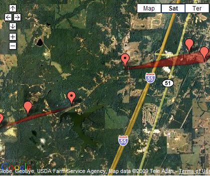 |
Location / Time of event: Copiah County, 834pm CST 12/9/08
Beginning Point: 2.2 miles northwest of Gallman
Ending Point: 1.0 mile northwest of Gallman
Rating: EF1 with max winds at 86mph
Path Length: 1.2 miles
Maximum Width: 75 yards
Fatalities: 0
Injuries: 0
Summary of Damages: The tornado began around 2.2 miles northwest of Gallman near Lake Copiah along Sumrall Road. The main damage from this tornado was numerous large trees snapped and uprooted along the path. This path lasted for 1.2 miles before dissipating.
Location / Time of event: Copiah County, 839pm CST 12/9/08
Beginning Point: 3.1 miles southwest of Crystal Springs
Ending Point: 1.6 miles southwest of Crystal Springs
Rating: EF0 with max winds at 82mph
Path Length: 1.5 miles
Maximum Width: 75 yards
Fatalities: 0
Injuries: 0
Summary of Damages: The tornado touched down again along Dees Road about 3.1 miles southwest of Crystal Springs. The tornado caused considerable tree damage along its 1.5 mile path. A large tree was uprooted and fell on top of a residence along South Pat Harrison Road. The tornado was also responsible for tearing off the metal roof to a covered walkway at Crystal Springs Middle School. This is estimated to be around eight thousand dollars worth of damage. The tornado dissipated shortly after and no other damage was found.
US Dept of Commerce
National Oceanic and Atmospheric Administration
National Weather Service
Jackson, Mississippi
234 Weather Service Dr.
Flowood, MS 39232
601-936-2189
Comments? Questions? Please Contact Us.

