February 9-11, 2011 Snow and Record Cold
Event Summary
Winter precipitation struck the ArkLaMiss again for the second time in about a week! A continued cold airmass remained in place over the region thanks to several rounds of cold air intrusions over the ArkLaMiss. Moisture increased over the region ahead of an upper disturbance that would again bring snow and sleet to North Texas and Oklahoma. Precipitation began moving in from the west during the morning hours. The Mississippi Delta saw only snow and had a dusting of snow on the ground by the noon hour. The remainder of the ArkLaMiss began as rain and slowly transitioned to a rain/snow/sleet mix as the morning and afternoon progressed. Temperatures slowly began to fall over the region and the rain transitioned to snow across the I-20 corridor by mid afternoon. As the upper disturbance tracked east across the area precipitation continued across the region with the Mississippi Delta continuing to see all snow, and the areas along the Highway 84 corridor seeing all rain. The section in the middle of the ArkLaMiss, generally along the I-20 corridor, ended up being in the mixed precipitation zone. Temperatures flirted with the freezing mark and rain transitioned to snow, but generally not long enough in the Jackson area to accumulate very much. Snow accumulation was greater in Vicksburg and then over to Meridian, but the Jackson metro area was just too warm just above the surface which enabled the snow to melt enough into a cold rain. Some locations in far northern Mississippi saw snow amounts of 7 to 8 inches. Total snowfall amounts within in the Jackson CWA were generally 4 to 6 inches generally along the Highway 82 corridor, with the highest snowfall amount of 6 inches being reported near Winona and Starkville. Snowfall of 2 to 4 inches fell from Southeast Arkansas through northern Madison County to northern Lauderdale County. Further south, along the I-20 corridor, amounts ranged from one half of an inch in locations that saw more rain than snow to 2 inches.
Snowfall Totals from February 9-10, 2011. Click for a larger image.
 |
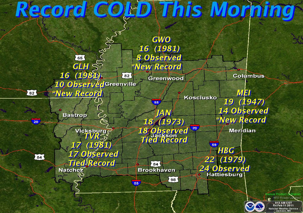
The precipitation moved out of the ArkLaMiss around 11pm and a cold night ensued over the region. Overnight low temperatures fell to around 14 and 13 at Greenwood and Greenville, respectively. These were the coldest temperatures as snowfall allowed readings to drop despite the brisk north wind and cloud cover. An arctic airmass remained over the region the following day, which allowed temperatures to struggle to rise above freezing. High temperatures on the 10th ranged from 30 in Greenville to 31 and 32 in Jackson and Meridian, which made snow melt virtually impossible. Locations along the Highway 84 corridor were able to rise to around 35 to 37 degrees. With clearing skies and calm winds, lows plummeted early Friday morning. The coldest temperatures in the state were located north of the Jackson CWA, and reached the single digits. The lowest temperature was 4 degrees in Independence, MS which is about 43 miles south of Memphis, TN. The coldest temperature in the Jackson CWA was at Greenwood, which saw a bone-chilling 8 degrees! Many official climate sites saw record lows broken. The following table lists some of the low temperatures and the records that were broken.
|
|
|

