
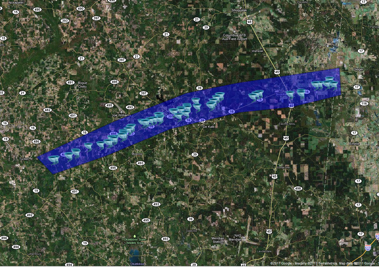
Neshoba/Kemper County Tornado
Click on Map Below to Zoom In/Out and Damage Notation
|
Event Summary The tornado started just west of County Road 450, downing some pine trees. As it crossed County Road 450, it began downing numerous trees, pushed a mobile home over, and damaged the roof of a house. The tornado intensified as it cross MS Highway 491, destroying a large portion of two chicken houses down to the ground, and causing extensive tree damage. The tornado then appeared to weaken slightly as it crossed County Road 729 and then crossed into Kemper County near White Store Road. Numerous trees were snapped, and a home suffered some minor to moderate damage along County Road 729. |
|
The tornado intensified as it approached Little Rock Road and MS Highway 495. The tornado reached an EF-3 intensity at this location, causing extensive structural damage to two frame homes, completely destroying two mobile homes and carrying the remains some distance, snapping several power poles, and causing intense tree damage with some denuded trees. The tornado weakened a bit from here, but continued to cause extensive tree damage and downed power poles and lines as it moved east-northeast. As the tornado crossed Highway 16 for the first time west of De Kalb, it continued to cause EF-2 type damage, destroying several mobile homes, heavily damaging the second story of a frame home, and causing roof damage to other frame homes. Extensive tree and power line damage also occurred in this area.
As the tornado crossed Neely Town Road north of De Kalb it again caused EF-3 type damage, completely destroying a double-wide mobile home and wrapping the frame around trees several hundred yards away and carrying the remnants across a road a considerable distance away, along with intense tree damage including denuded trees, and snapped power poles. It also destroyed another mobile home and caused roof damage to nearby frame homes. It continued east, causing extensive tree damage across MS Highway 39, and then caused EF-3 damage again as it crossed Old De Kalb-Scooba Road. Tree damage was the most impressive of anywhere along the track in this area, with large swaths of area where nearly every tree was snapped and many trees were denuded. Additionally, a frame home suffered heavy damage with the roof mainly gone and some walls heavily damaged, another home had heavy roof damage, and some outbuildings were destroyed. This was also where the tornado reached its maximum width of three-quarters of a mile.
The tornado then weakened somewhat and narrowed as it crossed MS Highway 16 west of Scooba. Numerous trees and a couple of power poles were snapped in this area. The tornado then crossed US Highway 45 south of Scooba where it was relatively narrow but intense with damage on the border of EF-2/EF-3. A large warehouse building was totally destroyed, a pickup truck was moved a considerable distance, intense tree damage occurred with some denuding, and three homes suffered roof damage.
After crossing US Highway 45, the tornado widened again, and caused heavy damage in the area east of Scooba, particularly along MS Highway 16 near Giles Road. The tornado caused heavy roof damage to several homes and intense tree damage, with some denuding of trees occurring again. A number of power poles were snapped in the area as well. The tornado crossed into Alabama along and north of MS Highway 16. Additional information on this tornado can be found in statements issued by the National Weather Service in Birmingham.
 |
 |
 |
 |
 |
 |
 |
 |
 |
 |
 |
|

