
Track of Hurricane Isaac
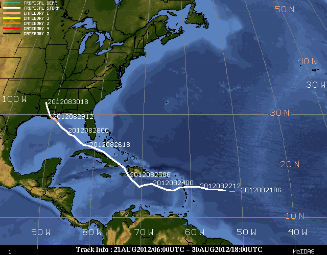
(Image courtesy of University Of Wisconsin - Madison Cooperative Institute for Meteorological Satellite Studies)
Event Summary
Tropical Depression Nine formed in the Atlantic, east of the Lesser Antilles, on the morning of August 21, 2012. Twelve hours later, Tropical Depression Nine had strengthened into Tropical Storm Isaac. Isaac continued to track through the eastern Caribbean Sea and into the Florida Straits while still maintaining high end tropical storm strength. Just before noon Central time, Isaac was found to have reached hurricane strength with winds of 75mph, as he was located about 75 miles south-southeast of the mouth of the Mississippi River, or about 160 miles southeast of New Orleans, LA. An outer rainband from Isaac brought some showers to portions of the ArkLaMiss during the afternoon of the 28th, while the center of Isaac was still churning in the Gulf of America. At 6:45pm CDT on August 28th, Hurricane Isaac made a brief landfall along the coast of Southeast Louisiana in Plaquemines Parish. Maximum sustained winds were 80mph at this landfall. Isaac did not remain over land for long as he was back over water again by 9pm that same evening. Isaac made his second landfall along the coast of Southeast Louisiana, just to the west of Port Fourchon, around 2:15am CDT August 29th, again with maximum sustained winds of 80mph.
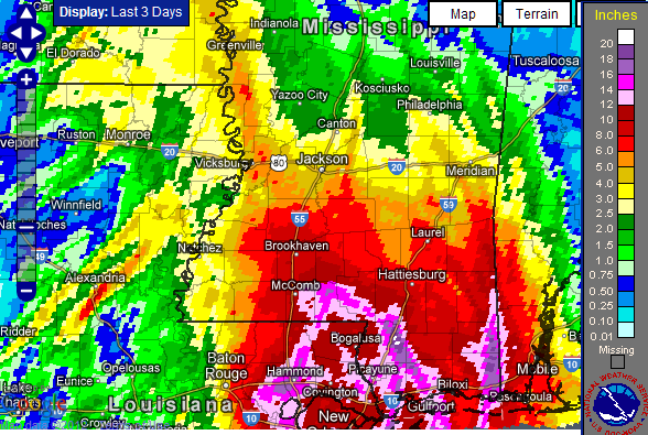
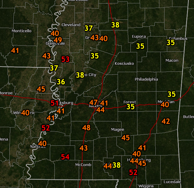
Isaac moved very slowly to the north and northwest over the course of August 29th, which made for prolonged impacts. Forward motion of about 5 mph lead to tremendous flooding issues for both Louisiana and portions of Mississippi south of I-20. Mid-day on August 29th, Isaac was downgraded to a Tropical Storm, but this was not much relief to the many residents who were being inundated with rain and wind. Storm total amounts from portions of Marion County indicated at least 10 to 15 inches fell. Numerous homes and buildings were flooded and some water rescues occurred in Lamar, Marion and Clarke counties. Further to the north, flooding issues were not quite as bad with about 5 to 7 inches of rain falling from the I-20 corridor and north. Tropical storm force wind gusts were noted as far north as Bolivar County, with the Golden Triangle region not seeing winds reach more than tropical depression strength. The worst of the wind was felt generally along and south of an axis from Marion County to Adams County. Numerous trees were down in Adams County, leaving many without power for several days. 80 percent of the roads were blocked in Franklin County due to downed trees.
With all of the rain that fell, some of the area rivers filled quickly. Minor flooding was recorded on the lower Pearl River at Rockport and Monticello, as well as on Bouie Creek at Hattiesburg and Tallahala Creek at Laurel. The biggest river impact in the Jackson Hydrologic Service Area was on Black Creek at Brooklyn. Black Creek entered moderate flooding and finally crested at 26.71 feet on August 31st at 5pm. This will go down as the second highest crest in history for this particular river and forecast point. This river flooding caused damage to 15 homes both upstream and downstream of the river gage.
The winds and flooding were not all Isaac brought as a couple of tornadoes touched down in East Mississippi. Two tornadoes, one in Clarke County and one in Lauderdale County, occurred the morning of August 30th. Both were rated EF-1 with winds around 100 mph. The tornado in Clarke County, near Crandall, resulted in 3 injuries from residents in a mobile home. There was a death during Isaac in Holmes County when a 64 year old woman was killed by a tree falling on her car. Isaac finally moved quickly out of the region by the afternoon of the 30th, but still left remnant bands to affect the region with afternoon showers and thunderstorms. Isaac was downgraded to a tropical depression by late afternoon on the 30th as it continued to track to the northwest into Missouri and the Ohio Valley.
Survey Information- Click on the location in the table for additional maps and details
| Location | Start/ End Time |
Event Type | Fatalities/ Injuries |
Path Length | Path Width |
| Clarke County 2 ENE Crandall to 5 ESE Sykes |
8/30 9:49 am- 9:56 am |
EF-1 Tornado 105 mph |
3 injuries | 6.1 miles | 100 yards |
| Lauderdale County 1 ENE Causeyville to 1 N Causeyville |
8/30 10:18 am- 10:20 am |
EF-1 Tornado 100 mph |
none | 1.4 miles | 100 yards |
Satellite and Radar Images
(Courtesy NESDIS) |
Suomi NPP VIIRS True Color Image |
Suomi NPP VIIRS Day-Night Band Reflectance (Courtesy NASA SPoRT)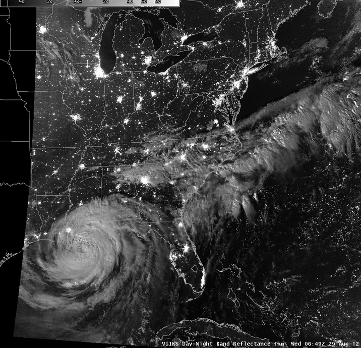 |
3-Day Radar Loop via UAH Severe Weather and Radar Research Group (Click image for animation) |
Isaac Track Montage (Courtesy of University Of Wisconsin - Madison Cooperative Institute for Meteorological Satellite Studies)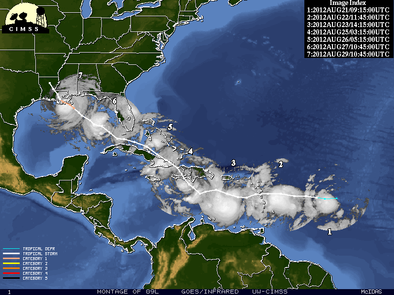 |
Rainfall and Flooding
Peak Wind Gusts
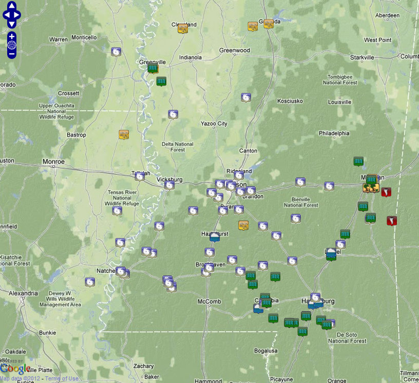
Listing of peak wind measurements
Local Storm Reports

Additional Information

