Jackson, Mississippi
Weather Forecast Office
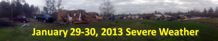
Bolivar County Tornado #2
|
Event Summary The tornado started along Evans Road west-southwest of the Skene community. As it moved northeast, it crossed Highway 448 and Shaw-Skene Road, causing minor roof damage to a few homes, removing part of an awning from a home, snapped some large limbs and small trees and knocked down a few wooden power poles. The tornado reached its maximum strength as it crossed Cleveland Crossing Road, knocking down several power poles, downing some traffic signs and dropping roofing debris near the road. The tornado continued northeast, causing some shingle damage to a couple of homes along Highway 8 and snapped some large limbs. The tornado appeared to dissipate near this point just south of the Cleveland Municipal Airport. |
|
US Dept of Commerce
National Oceanic and Atmospheric Administration
National Weather Service
Jackson, Mississippi
234 Weather Service Dr.
Flowood, MS 39232
601-936-2189
Comments? Questions? Please Contact Us.

