Lamar and Forrest County Tornado
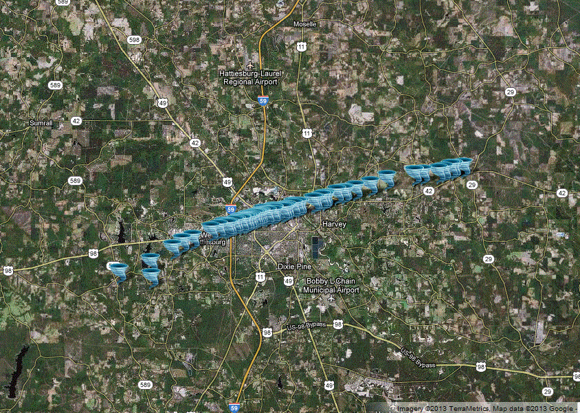
Click on map above to see entire event tracks and damage point notation
|
Event Summary The tornado started along Highway 589, where some limbs and small trees were downed. It became intense rather quickly, producing significant damage as it moved through the West Lake Serene area. The tornado reached its maximum intensity in the area around and just southwest of Oak Grove High School. There was a brick home in a subdivision southwest of the high school, just west of old Highway 11, that was completely leveled with all interior and exterior walls down, and a fair amount of large debris was blown downstream. Additionally, very high end timber damage occurred in this location with a number of trees showing debarking and denuding. Several other homes in this subdivision also sustained EF-2 to EF-3 damage. As the tornado crossed old Highway 11, it produced extensive damage on the campus of Oak Grove High School. The field house adjoining the football stadium was destroyed, the baseball stadium and a large metal building adjoining the stadium were essentially destroyed, and several large steel/concrete light standards were snapped at both the baseball and football stadiums. A vehicle was thrown from the parking lot adjoining the baseball stadium, up a small hill and was deposited near the pitching mound in the middle of the baseball field. The main building of the high school also suffered some roof damage. |
|
||||||||||||||
|
The tornado then moved northeast into the heavily populated areas of Oak Grove and West Hattiesburg, including areas along Lincoln Road Extension, Weathersby Road, Oak Grove Road, and the area just south of Highway 98 along Clark, Lamar and Foxgate Avenues. Numerous homes were destroyed or suffered major damage, and a few homes showed evidence of high end EF-3 type damage. Dozens of power poles were snapped, extensive tree damage occurred. Video evidence and ground survey damage appeared to indicate that the tornado was multi-vortex in nature during its Lamar County portion. Just before crossing Interstate 59, it caused significant roof damage to a number of apartment buildings just west of the interstate. In total in Lamar county, preliminary estimates from emergency management indicate that 51 homes were destroyed and 170 suffered major damage. There were 8 reported injuries, 2 of which were critical. |
|||||||||||||||
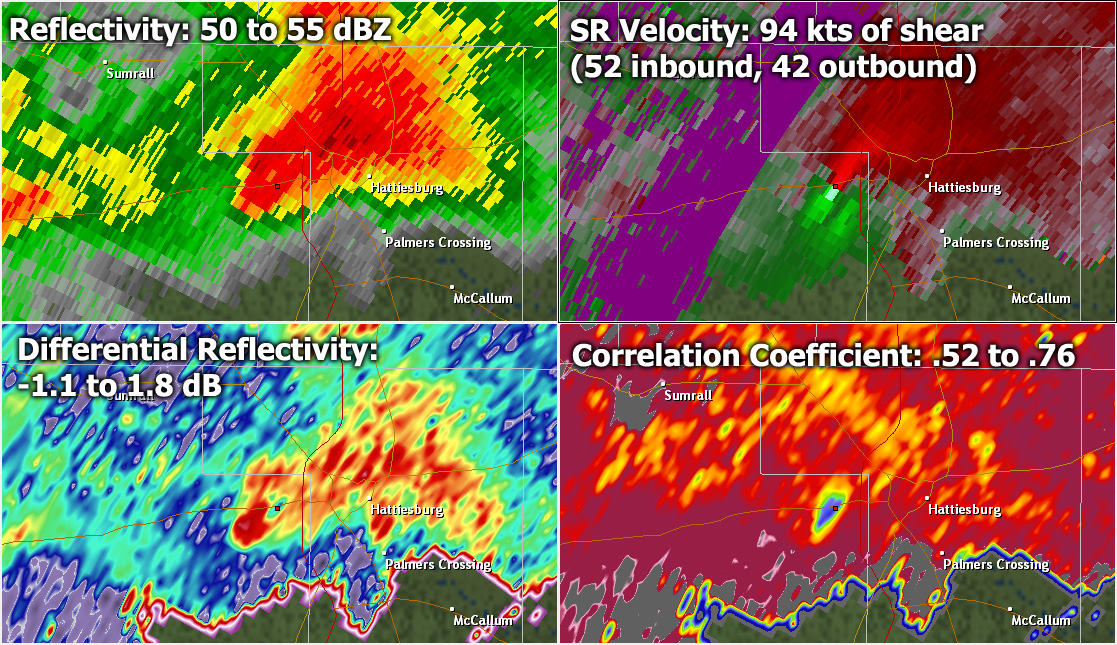
Radar Imagery
Thanks to recent dual-pol upgrades at area Doppler radar sites, we could also confirm the presence of tornadic debris. Here is a screen capture from the Mobile, AL radar at 5:13 pm as the tornado was moving through the West Hattiesburg/Oak Grove area. The more traditional radar products shown at the top (base reflectivity, storm relative velocity) were showing a severe thunderstorm, with strong and tight rotation at just over 7,000 feet above the ground. It was the dual-pol products on the bottom of this image that provided additional confirmation that this rotation must have been extending to the ground. The correlation coefficient (CC) product in the bottom-right helps to provide an idea of the consistency of the shape of the targets being reflected back to the radar. Higher values shows greater consistency (for instance, all rain), while lower values show less consistency (a mixture of targets). In this image we see an area of lower CC, which is actually an indication of tornadic debris of various shapes and sizes. In addition, the differential reflectivity product indicated values close to 0, which would also be expected with tornadic debris. Dual-pol continues to prove to be a powerful tool in our arsenal of technology enabling us to track severe weather.