February 23, 2016 Tornadoes
Event Summary
Widespread severe weather occurred on Wednesday with a mix of damaging winds, hail and several tornadoes. The focus of the severe weather was across southern Mississippi, with a few weaker tornadoes in central Mississippi. The hardest hit areas were across Marion, Lamar and Forrest Counties. A strong tornado (EF-2) in Lamar County sadly caused one fatality just west of Purvis, Mississippi. Other tornadoes occurred in Lincoln, Simpson and Yazoo Counties as well. This event was driven by a strong disturbance that swung across the area during the late afternoon to early evening hours. As this strong disturbance dropped into the southern Plains and lower Mississippi River Valley, a surface low developed and deepened as it tracked across northeast Louisiana and into central to northwest Mississippi late that evening. The atmospheric response to this was for a rapid increase in winds aloft and higher low level moisture. This combination set the stage for an unstable environment that contained high levels of wind shear which supported and sustained tornado development, with the best combination for development of tornadoes, including some strong, in southeast Mississippi.
Tornado Event Track Map
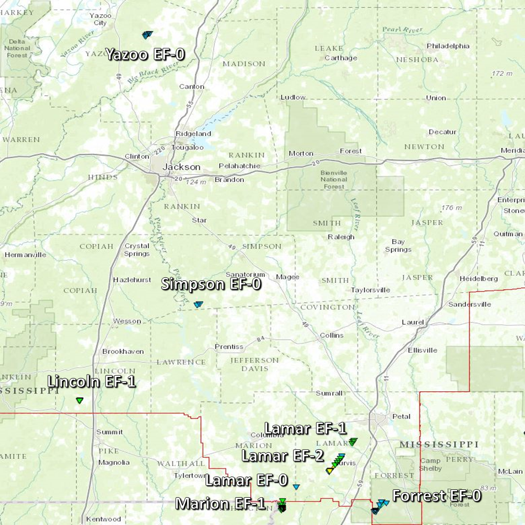
Click on map above to see entire event tracks and damage point notation.
Click on the location in the table for additional maps and details below.
Lincoln EF-1 Tornado
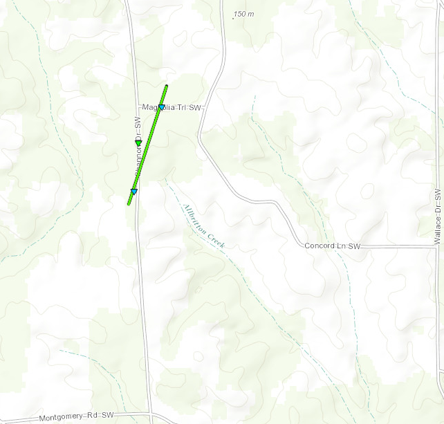
Click on map above to see entire damage point notation and damage pictures at select points.
|
Event Summary
The tornado began just west-southwest of Shannon Drive in a wooded area where a few large trees were uprooted and a few tops of trees were snapped. As the tornado crossed Shannon Drive, many large trees were snapped and uprooted with one causing minor roof damage to a home. The tornado then crossed Magnolia Trail where a large limb was snapped and skirting was blown off of a mobile home into a pasture across the road. The tornado continued around 100 yards or so into the pasture where a feed house was damaged and tin was strewn around. The tornado lifted soon after in this pasture.
|
Rating:
(Click for EF Scale) |
EF-1 |
| Estimated Maximum Wind: |
90 mph |
| Fatalities/Injuries: |
none |
| Damage Path Length: |
0.5 miles |
| Maximum Path Width: |
75 yards |
| Approximate Start Point/Time: |
5 E Centerpoint
3:45 pm
|
| Approximate End Point/Time: |
5 E Centerpoint
3:47 pm
|
|
Back to the table
Marion EF-1 Tornado
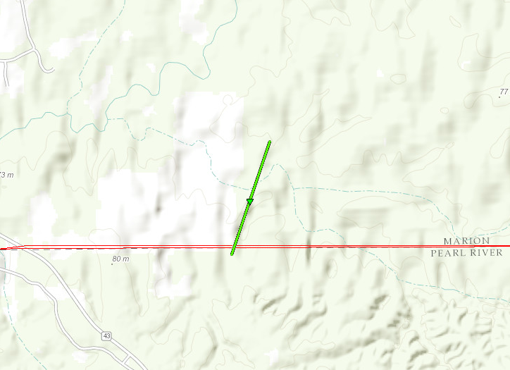
Click on map above to see entire damage point notation and damage pictures at select points.
|
Event Summary
This tornado started in Pearl River County and crossed into southwest Marion County where it snapped numerous softwood and hardwood trees. The tornado also caused roof damage to a hunting lodge just across the county line. The tornado continued north-northeast and ended just south of Pearl Bluff Circle, snapping a few more trees along the way.
|
Rating:
(Click for EF Scale) |
EF-1 |
| Estimated Maximum Wind: |
105 mph |
| Fatalities/Injuries: |
none |
| Damage Path Length: |
2.3 miles |
| Maximum Path Width: |
200 yards |
| Approximate Start Point/Time: |
5 ESE Sandy Hook
3:54 pm
|
| Approximate End Point/Time: |
6 E Sandy Hook
3:58 pm
|
|
Back to the table
Lamar EF-0 Tornado
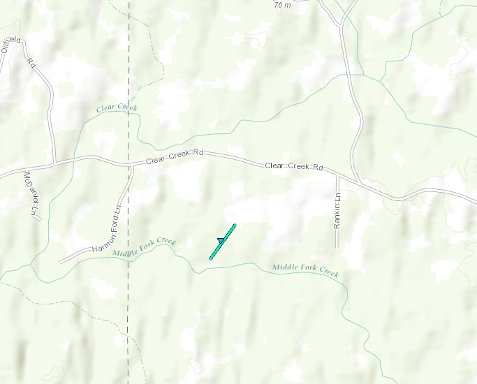
Click on map above to see entire damage point notation and damage pictures at select points.
|
Event Summary
This brief tornado touchdown snapped and uprooted several trees just south of Clear Creek Road in southwest Lamar County.
|
Rating:
(Click for EF Scale) |
EF-0 |
| Estimated Maximum Wind: |
80 mph |
| Fatalities/Injuries: |
none |
| Damage Path Length: |
0.1 miles |
| Maximum Path Width: |
25 yards |
| Approximate Start Point/Time: |
4 WSW Baxterville
4:07 pm
|
| Approximate End Point/Time: |
4 WSW Baxterville
4:07 pm
|
|
Back to the table
Lamar EF-2 Tornado
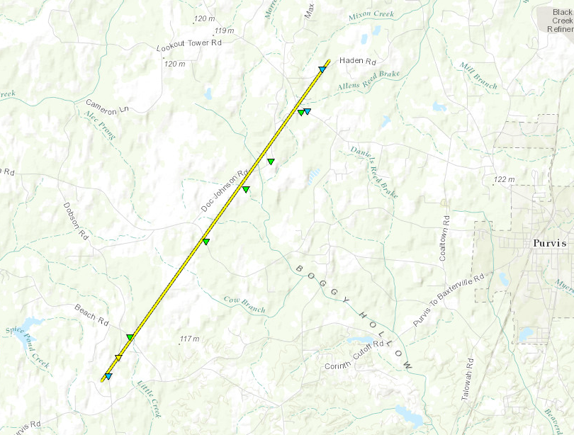
Click on map above to see entire damage point notation and damage pictures at select points.
|
Event Summary
The tornado began just southwest of Sones Road where it snapped a few limbs. The tornado continued northeast across Martin Bird Lane. The tornado was at its strongest at this point where it destroyed a double-wide mobile home. The debris from the mobile home was thrown nearly 125 yards from its original point. A car was also rolled approximately 75 yards. Two power poles were snapped along with a few trees at this location also. This location is where the fatality occurred. The tornado continued northeast across Beach Road where it snapped a few more trees. The tornado then continued northeast along Doc Johnson Road snapping a few trees along the way. This tornado damaged an outbuilding and also took the roof off of a chicken house along Doc Johnson Road. The tornado ended near Haden Road where it snapped a few more trees.
|
Rating:
(Click for EF Scale) |
EF-2 |
| Estimated Maximum Wind: |
115 mph |
| Fatalities/Injuries: |
Deaths: 1 |
| Damage Path Length: |
5.6 miles |
| Maximum Path Width: |
100 yards |
| Approximate Start Point/Time: |
5 ENE Baxterville
4:15 pm
|
| Approximate End Point/Time: |
4 NW Purvis
4:23 pm
|
|
Back to the table
Lamar EF-1 Tornado
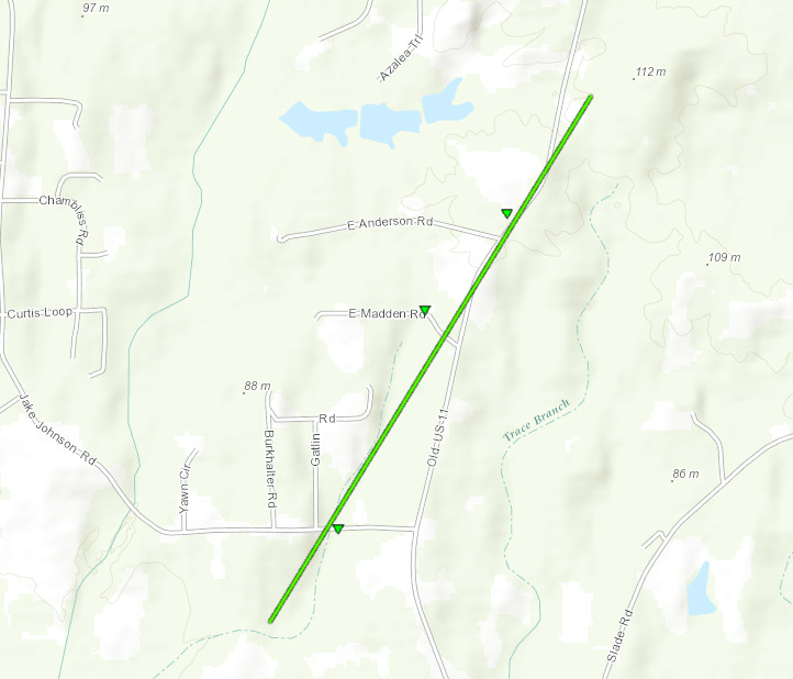
Click on map above to see entire damage point notation and damage pictures at select points.
|
Event Summary
This tornado began just southwest of Jake Johnson Road where it snapped a few trees. It continued northeast along old US 11 and ended just north of East Anderson Road, snapping a few trees and causing some minor roof damage along the way.
|
Rating:
(Click for EF Scale) |
EF-1 |
| Estimated Maximum Wind: |
90 mph |
| Fatalities/Injuries: |
none |
| Damage Path Length: |
1.4 miles |
| Maximum Path Width: |
75 yards |
| Approximate Start Point/Time: |
7 WSW West Hattiesburg
4:29 pm
|
| Approximate End Point/Time: |
6 SSW West Hattiesburg
4:31 pm
|
|
Back to the table
Yazoo EF-0 Tornado
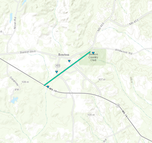
Click on map above to see entire damage point notation and damage pictures at select points.
|
Event Summary
This weak tornado touched down along Highway 16 southwest of Benton, uprooting some trees. It continued northeast and crossed Highway 433, causing trees to be uprooted in a concentric pattern with one falling on a house along Highway 433. The tornado continued northeast over Alton Circle and broke large limbs along Benton Boulevard. The tornado continued into Benton Country Club where a large tree was snapped and small limbs were broken along the path. The tornado lifted just southwest of Wildwood Road.
|
Rating:
(Click for EF Scale) |
EF-0 |
| Estimated Maximum Wind: |
85 mph |
| Fatalities/Injuries: |
none |
| Damage Path Length: |
1.2 miles |
| Maximum Path Width: |
100 yards |
| Approximate Start Point/Time: |
1 SSW Benton
4:42 pm
|
| Approximate End Point/Time: |
1 ENE Benton
4:44 pm
|
|
Back to the table
Simpson EF-0 Tornado
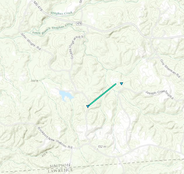
Click on map above to see entire damage point notation and damage pictures at select points.
|
Event Summary
This tornado started along Grubbs Hog Farm Road, uprooting trees and snapping large limbs off the tops of some trees. The tornado continued northeast into a wooded area. A few more trees were downed in the woods just northwest of Joseph Crawford Road before lifting near this location soon after.
|
Rating:
(Click for EF Scale) |
EF-0 |
| Estimated Maximum Wind: |
80 mph |
| Fatalities/Injuries: |
none |
| Damage Path Length: |
0.6 miles |
| Maximum Path Width: |
40 yards |
| Approximate Start Point/Time: |
4 WSW Shivers
4:46 pm
|
| Approximate End Point/Time: |
4 WSW Shivers
4:47 pm
|
|
Back to the table
Forrest EF-0 Tornado
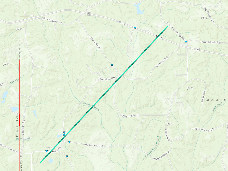
Click on map above to see entire damage point notation and damage pictures at select points.
|
Event Summary
This tornado began near Entrekin Road snapping a few trees along with a power pole. The tornado continued northeast across Havard Road and ended near MS 13 snapping a few more trees along the way.
|
Rating:
(Click for EF Scale) |
EF-0 |
| Estimated Maximum Wind: |
75 mph |
| Fatalities/Injuries: |
none |
| Damage Path Length: |
3.9 miles |
| Maximum Path Width: |
75 yards |
| Approximate Start Point/Time: |
8 ESE Lumberton
6:01 pm
|
| Approximate End Point/Time: |
6 WNW Maxie
6:09 pm
|
|
Back to the table
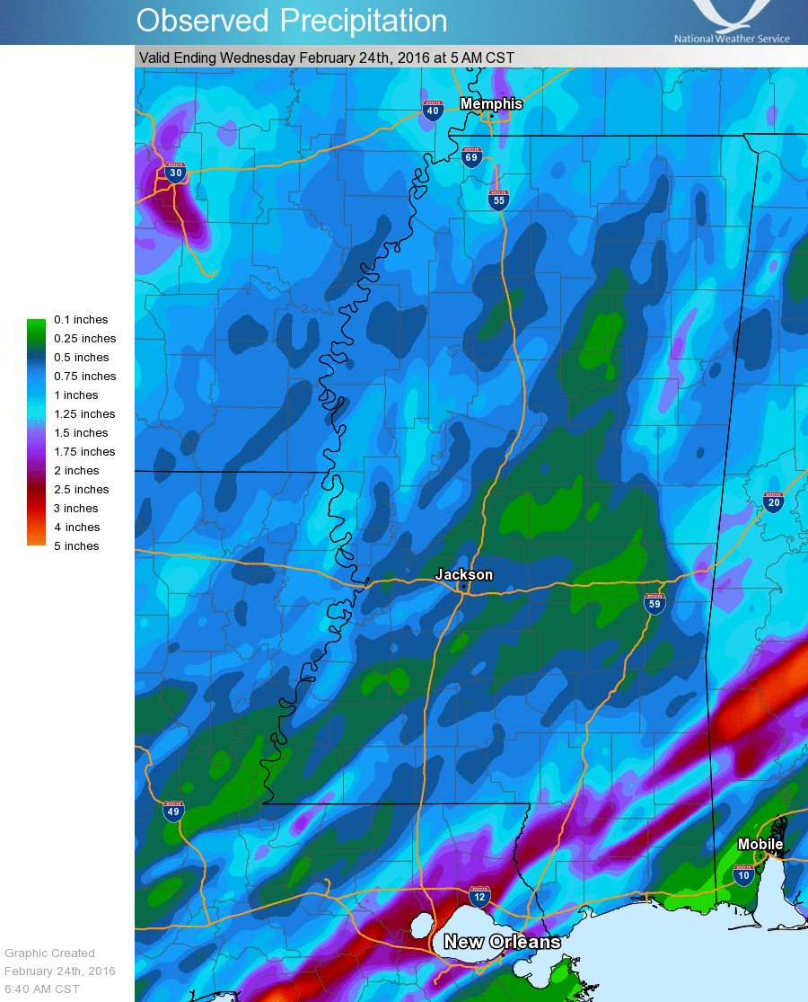
Precipitation Summary
Back to the top
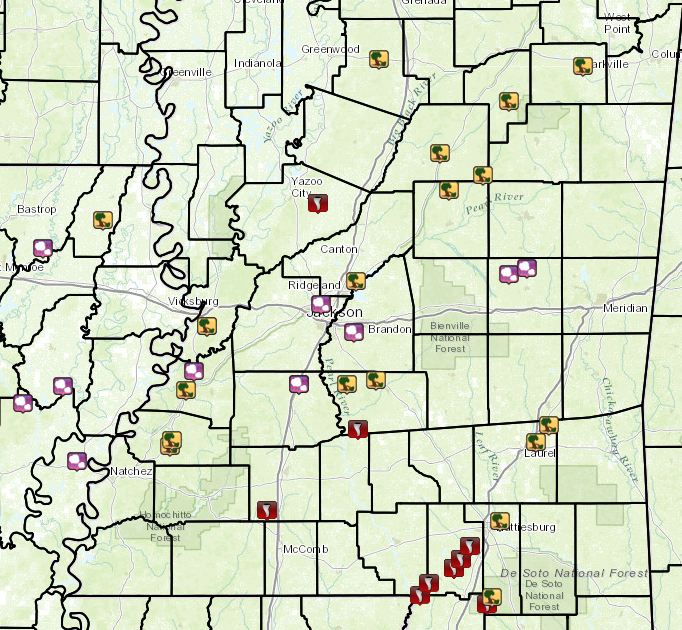
Local Storm Reports
Click on the map below for additional details.

Back to the top

