March 8-13, 2016 Flooding & Tornadoes
Event Summary
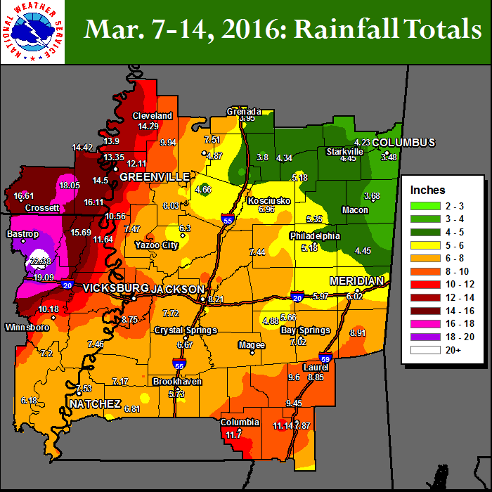
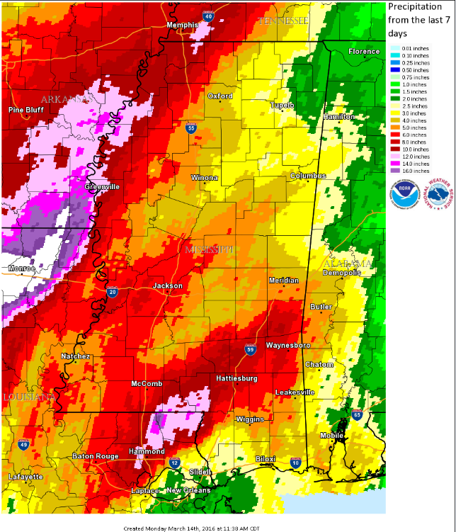
As high pressure over the East Coast refused to move, a storm system approaching the ArkLaMiss from the west, stalled just to the west of the region on Monday March 7th. While warm moist air from the Gulf of America filtered north and encompassed the region, a series of potent upper level disturbances began lifting northeast across the Lower Mississippi River Valley. This set the stage for multiple rounds of torrential rains that fell almost continuously across the ArkLaMiss from Tuesday, March 8th through Saturday, March 12th. These prolonged torrential rains resulted in widespread flash flooding and river flooding across the region, with numerous area rivers reaching moderate and major flood stages. Floodwaters damaged numerous homes, businesses, and closed many primary and secondary roads across the region, with some secondary roads washed out.
In addition, one weak tornado developed on Thursday, March 10 as a line of storms began to finally push to the east over central Mississippi. This weak EF-0 tornado touched down just west of Raleigh, snapping a few trees and causing minor damage to a metal roof of an outbuilding.
As the storm system finally exited the region late Saturday, another fast moving, compact storm system followed in its wake during the evening of Sunday, March 13th. This system brought another round of heavy rain to the Delta Region, in addition to several reports of hail and damaging straight line winds. Two tornadoes were spawned by this system as well. An EF-1 tornado affected the city of Dermott in Chicot County in Arkansas and continued into Desha County in Arkansas, causing quite a bit of damage to the South Delta Regional Correctional Facility in Dermott and 1 injury. An EF-0 tornado also touched down near Cleveland in Bolivar County in Mississippi.
Precipitation Summary
Rainfall Across the ArkLaMiss
Back to the top
Rainfall Across the Region: March 7-14, 2016
Back to the top
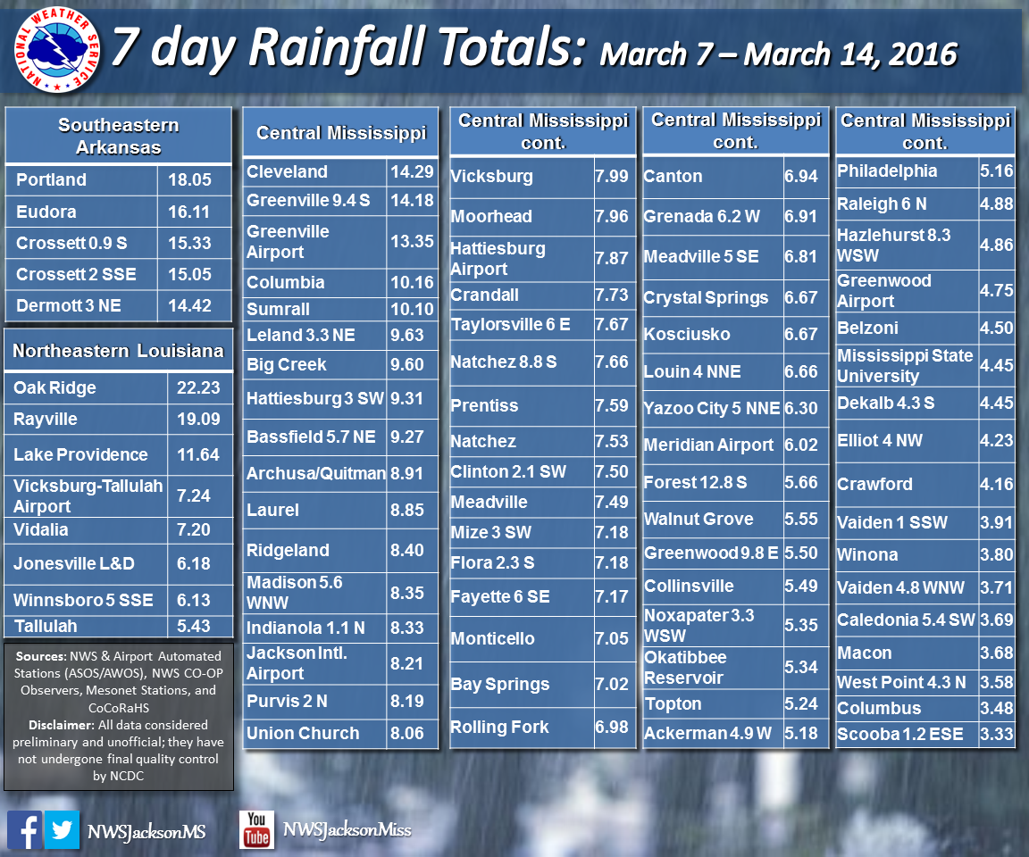
Rainfall Totals
Back to the top
Click on the location in the table for additional maps and details below.
3/10/16 Raleigh EF-0 Tornado
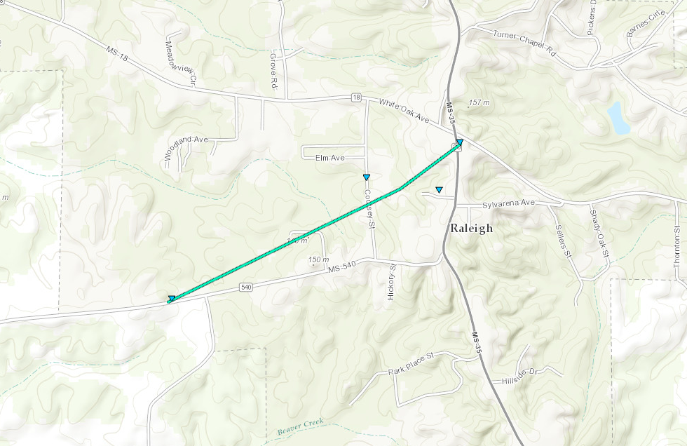
Click on map above to see entire damage point notation and damage pictures at select points.
|
Event Summary
The tornado began just off of Highway 540 west of Raleigh snapping a few trees. It continued across Court House Square, where it took part of a metal roof off of an outbuilding. The tornado ended near State Highway 35 where it snapped some limbs off of a tree.
|
Rating:
(Click for EF Scale) |
EF-0 |
| Estimated Maximum Wind: |
80 mph |
| Fatalities/Injuries: |
none |
| Damage Path Length: |
1.2 miles |
| Maximum Path Width: |
80 yards |
| Approximate Start Point/Time: |
1 W Raleigh
4:04 pm
|
| Approximate End Point/Time: |
Raleigh
4:07 pm
|
|
Back to the table
3/13/16 Chicot/Desha EF-1 Tornado
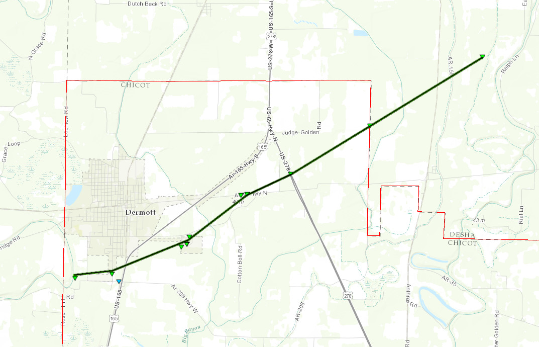
Click on map above to see entire damage point notation and damage pictures at select points.
|
Event Summary
This tornado started on the southwest side of Dermott just west of Buckner Lane. Here several trees were snapped. As it crossed Buckner, 6 power poles were taken down. It then crossed Trotter Street, where more trees were snapped with others uprooted. A fence was laid down as well. A few homes here had minor roof damage where shingles were blown off. The tornado then tracked across US Highway 165 where it moved through open field. It tracked into the South Delta Regional Correctional Facility. Quite a bit of damage was done to the facility as it took a direct hit. Several large sections of the outer fence were torn down. Five buildings on the south side of the complex sustained roof damage whereshingles and sheet paper were removed. The gym building, a metal structure, was heavily damaged where a large section of wall was removed. The main building of the complex suffered roof damage where roughly half of the roof was lifted or had parts removed. The roof is not a typical roof; it has several layers. Large portions of the foam insulation were pulled out along with several sections of a thin roof covering. A couple of the guard watch towers had the windows blown out and some minor damage. One employee was injured trying to exit a tower and broke a leg. The tornado then moved into a wooded area, where trees were snapped and a metal carport was thrown and destroyed. As the tornado crossed Highway 35, many more trees were damaged. One home sustained minor roof damage on the south side of the highway. The tornado crossed US Highway 65 and snapped more trees. It then continued through a large wooded area and farmland and it moved into Desha County. It then crossed Highway 159 where many more trees were snapped and uprooted. Where it crossed Highway 159, a home sustained some minor roof damage and had the wood framed shed destroyed. A few power lines were down here as well. The tornado continued northeast into a wooded area where more trees were damaged. Though the tornado likely dissipated a bit farther east, no access was available to that area due to flooding.
|
Rating:
(Click for EF Scale) |
EF-1 |
| Estimated Maximum Wind: |
105 mph |
| Fatalities/Injuries: |
1 injury |
| Damage Path Length: |
9.2 miles
(2.6 mi. in Desha Co.) |
| Maximum Path Width: |
300 yards |
| Approximate Start Point/Time: |
1 SSW Dermott
9:15 pm
|
| Approximate End Point/Time: |
8 ENE Dermott
9:26 pm
|
|
Back to the table
3/13/16 Cleveland EF-0 Tornado
Click on map above to see entire damage point notation and damage pictures at select points.
|
Event Summary
The tornado began along Bishop Rd where it downed tree limbs at a funeral home and continued across W Sunflower Rd. Several sections of tin were blown off the end of a strip mall at the No Way Jose restaurant and a tree was downed along MS Highway 8. Along Bolling Ave, a fence and a shed were blown down and trees and tree limbs were downed. The tornado lifted as it reached a Delta State University intercollegiate athletic facility, where minor fence damage occurred.
NWS Jackson would like to thank the Bolivar County EMA for assisting with this damage survey.
|
Rating:
(Click for EF Scale) |
EF-0 |
| Estimated Maximum Wind: |
85 mph |
| Fatalities/Injuries: |
none |
| Damage Path Length: |
0.5 mile |
| Maximum Path Width: |
50 yards |
| Approximate Start Point/Time: |
1 WNW Cleveland
10:13 pm
|
| Approximate End Point/Time: |
1 NW Cleveland
10:14 pm
|
|
Back to the table
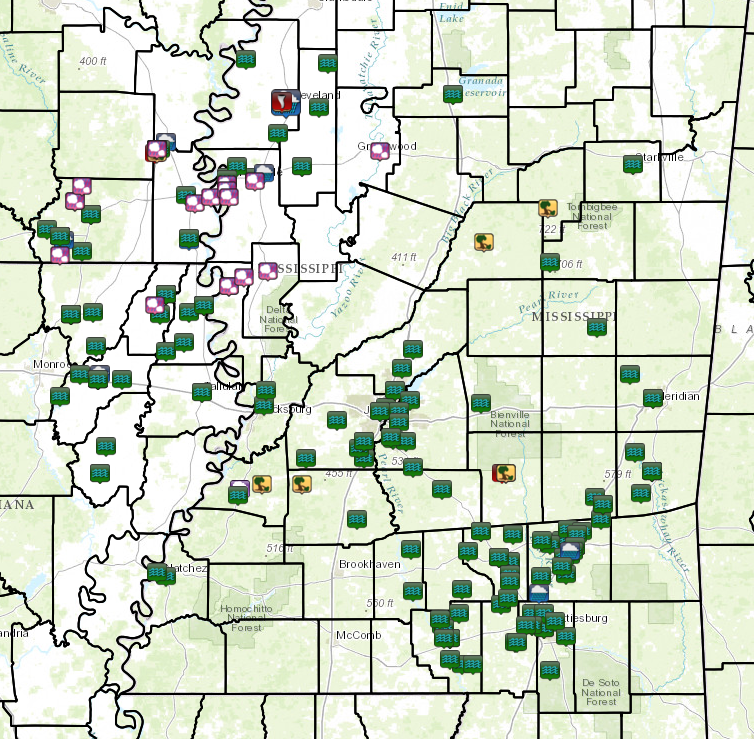
Local Storm Reports
Click on the map below for additional details.

Back to the top

