January 21, 2017 Tornadoes and Severe Thunderstorms
Event Summary
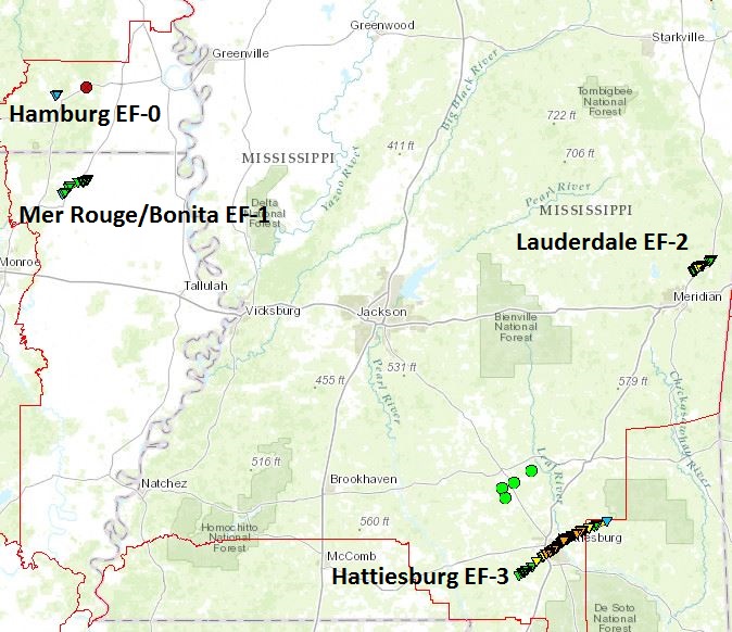
Two rounds of severe weather impacted the ArkLaMiss region - one beginning shortly after midnight on early Saturday morning and continuing through shortly before daybreak and a second beginning during the evening hours and continuing until just before midnight Saturday night. During the early morning event, areas south of I-20 in Mississippi were impacted. Most notably, an EF-3 tornado tracked through Lamar and Forrest counties, killing four people in Hattiesburg and injuring over 50 others. In addition, trees and powerlines were downed and large hail was reported in other areas across south Mississippi. Heavy rainfall resulted in flash flooding in parts of Forrest, Marion, Jones, and Jefferson counties. The evening event impacted a larger proportion of the area. An EF-2 tornado occurred in Lauderdale County near the Lauderdale community, injuring one. An EF-1 tornado occurred in Morehouse Parish tracking between Mer Rouge and Bonita. Also, a brief EF-0 tornado occurred near Hamburg in Ashley County. Wind damage was reported across parts of southeast Arkansas, southwest Mississippi, and east Mississippi. Meanwhile, large hail fell from central Louisiana through central and south Mississippi. Hail as large as 3.5" in diameter fell in Catahoula Parish.
01/02/17 Tornado Event Track Map
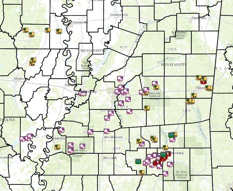
Local Storm Reports
Click on the map for additional details.

Back to the top
Click on the location in the table for additional maps and details below.
Lamar County/Hattiesburg/Petal EF-3 Tornado
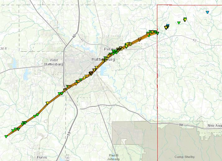
Click on map above to see entire damage point notation and damage pictures at select points.
|
Track Summary
This tornado began along Purvis-Oloh Road, about 5 miles west northwest of Purvis. It tracked northeast across portions of Lamar County causing mainly tree damage, uprooting and snapping softwood and hardwood trees. It caused some minor structural damage as well. The tornado crossed Old Highway 11, continuing to cause mainly tree damage (although at least a few structures were also damaged). The tornado began to gain strength as it reached Slade Road, where some homes received roof damage. As the tornado crossed Sullivan Kilrain Road, additional homes received significant roof and structural damage, especially on Carter Circle and Tatum Camp Road. Comprehensive assessments from Lamar County emergency management officials count 26 homes in the county either being destroyed or sustaining major damage with 52 homes receiving minor damage.
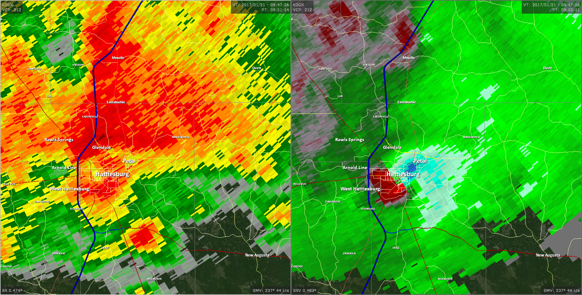
The tornado continued to gain strength as it crossed into Forrest County. There it struck a subdivision along Nellwood Drive, Lakeland Drive and Crestwood Drive and caused significant damage to many homes. Several homes received significant roof and structural damage. One home sustained significant damage and also was the site of one of the fatalities. As the tornado continued to track northeast, it caused tree damage and powerline damage. It struck a church along Helveston Road, which suffered damage to the top floor. As the tornado approached William Cary College, it intensified to EF3 strength, causing damage to numerous buildings on campus. The tornado then affected a mobile home park, downing trees and causing damage to mobile homes. Here, two more fatalities occurred. It then caused structural damage to several homes, churches and businesses on James Street and Alcorn Road. Another fatality occurred on Alcorn Road, when a tree fell on a home.
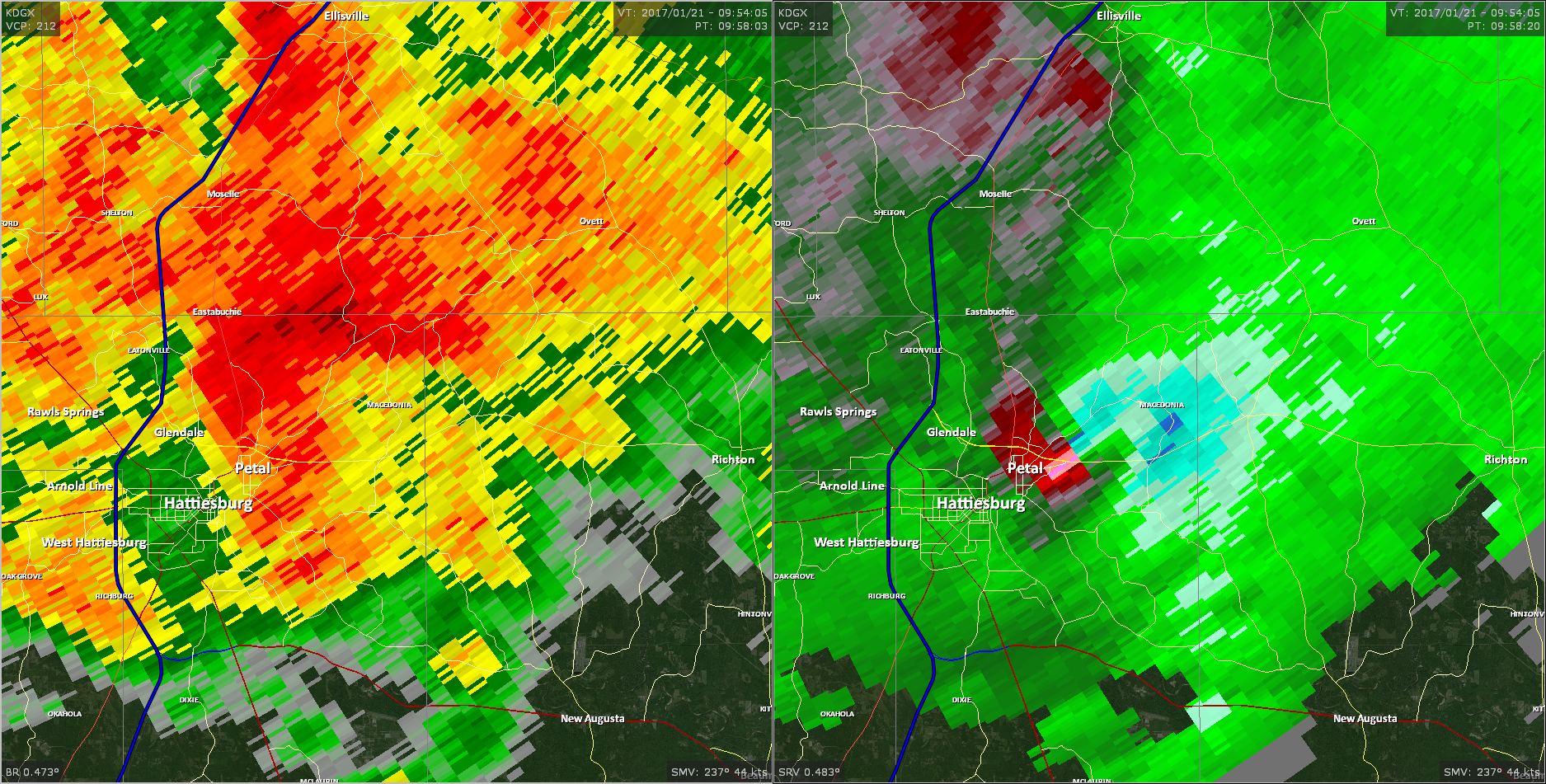
The tornado continued to track northeast, crossing the Leaf River and headed into Petal. Here the tornado got very wide and continued to cause EF2 type damage to businesses along Main Street and into the neighborhoods on the southern side of the city. Significant tree damage occurred and countless homes had minor to major roof damage in the neighborhood south of Hillcrest Loop. As the tornado reached Sun Circle, it intensified to EF3 strength again and caused significant damage to a few homes as well as moderate damage to many homes in the neighborhood. Beyond the subdivision along Sun Circle, the tornado caused tree damage again before reaching Evelyn Gandy Parkway. Here, it intensified to EF2 strength. It caused structural damage to an AT&T store by lifting the roof of the strip mall. It caused additional roof damage to several homes and a church along the Parkway as well as along Springridge Road and Corinth Road. As the tornado tore across Shawnee Trail, it caused impressive tree damage, which included snapping and uprooting hardwood and softwood trees. As the tornado tracked just south of HDR Lane, it took down two metal electrical transmission lines. The tornado then destroyed a house along Macedonia Road, as well as causing additional roof to other homes and taking down numerous trees. Additional impressive tree damage occurred along Old Richton Road and Tyroby Lane. The tornado continued to down trees as it tracked across Old Richton Road into Perry County. Comprehensive assessments from Forrest County emergency management officials count 499 homes in the county being destroyed or with major damage and 632 homes receiving minor damage.
The tornado path length in just Lamar and Forrest counties was 24.2 miles, although the entire path of the tornado in total was 31.3 miles. Along the entire tornado path the total number of homes destroyed or receiving major damage is estimated to be 531 with the number of homes having minor damage estimated at 689. The injury total for Lamar and Forrest counties was 56, with one injury occurring in Perry County.
Read more about the Perry County segment of this tornado here.
|
Rating:
(Click for EF Scale) |
EF-3 |
| Estimated Maximum Wind: |
145 mph |
| Fatalities/Injuries: |
Deaths: 4/Injuries: 57 |
| Damage Path Length: |
31.3 miles |
| Maximum Path Width: |
1/2 mile |
| Approximate Start Point/Time: |
5 WNW Purvis
3:35 am
|
| Approximate End Point/Time: |
5.5 NE Runnelstown
4:13 am
|
|
Radar Imagery
These images from the Slidell, LA Doppler radar show the storm at 3:47 am as the tornado approached I-59 near the Lamar/Forrest County line. The image on the left shows 0.5° base reflectivity data, and the image on the right shows 0.5° storm relative velocity data. Click on the thumbnail below for a higher resolution image.
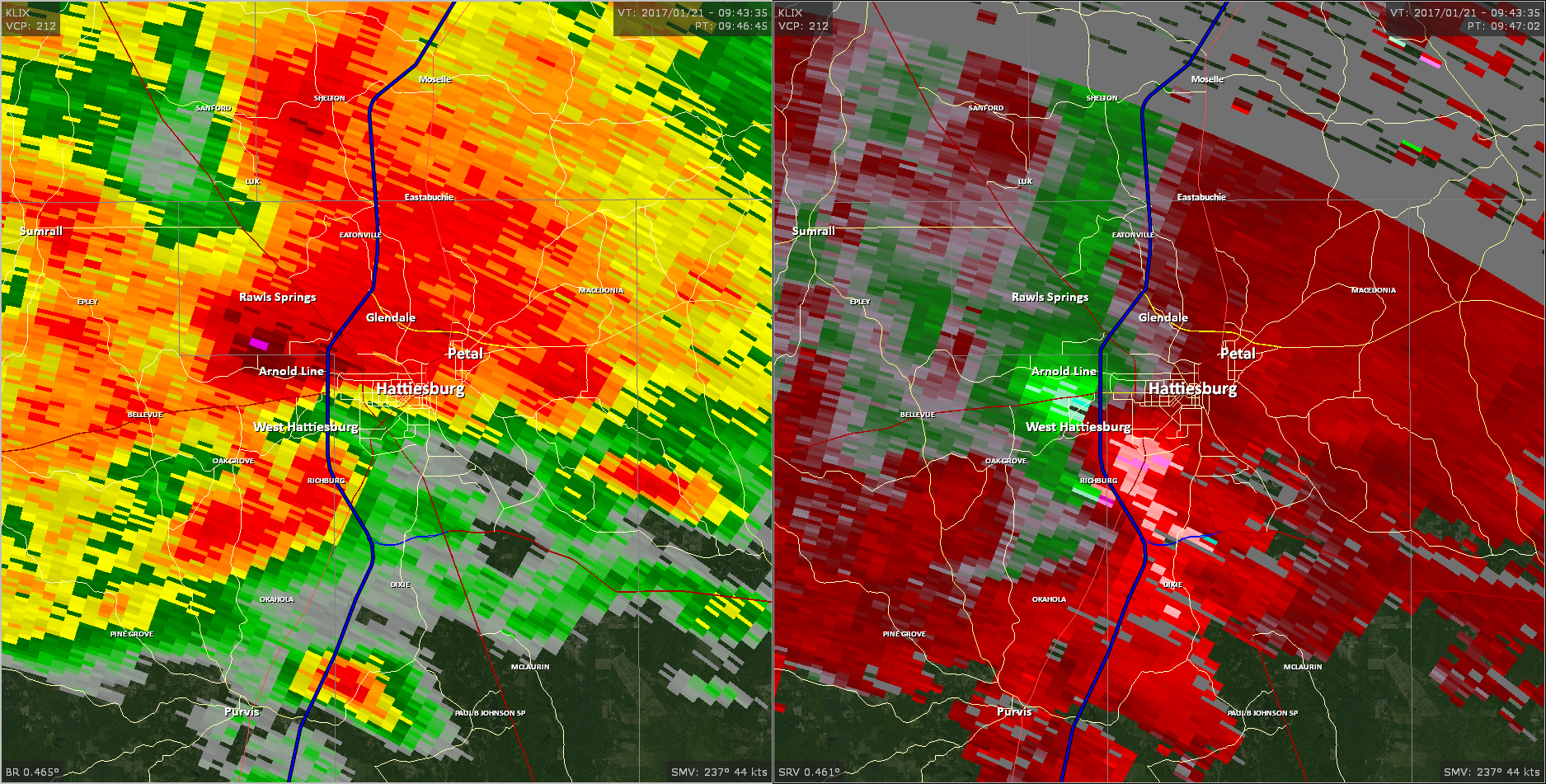
These images from the Brandon, MS Doppler radar show the storm at 3:52 am as the tornado moved across the south end of Hattiesburg. The image on the left shows 0.5° base reflectivity data, and the image on the right shows 0.5° storm relative velocity data. Click on the thumbnail below for a higher resolution image.
These images from the Brandon, MS Doppler radar show the storm at 3:58 am as the tornado continued eastward from Petal across northeastern Forrest County. The image on the left shows 0.5° base reflectivity data, and the image on the right shows 0.5° storm relative velocity data. Click on the thumbnail below for a higher resolution image.
Back to the table
Hamburg EF-0 Tornado
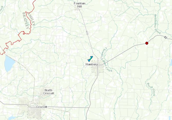
Click on map above to see entire damage point notation and damage pictures at select points.
|
Track Summary
A tornado was photographed on the northwest side of Hamburg. A damage survey was conducted, but no damage was found.
|
Rating:
(Click for EF Scale) |
EF-0 |
| Estimated Maximum Wind: |
70 mph |
| Fatalities/Injuries: |
none |
| Damage Path Length: |
2/3 mile |
| Maximum Path Width: |
50 yards |
| Approximate Start Point/Time: |
2 WNW Hamburg
8:45 pm
|
| Approximate End Point/Time: |
2 NW Hamburg
8:46 pm
|
|
Radar Imagery
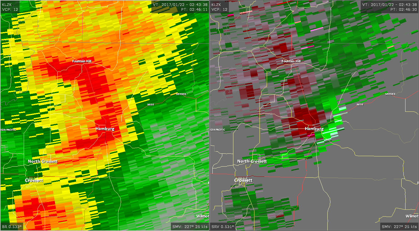
These images from the Little Rock Doppler radar show the storm at 8:46 pm as the tornado occurred near Hamburg. The image on the left shows 0.5° base reflectivity data, and the image on the right shows 0.5° storm relative velocity data. Click on the thumbnail below for a higher resolution image.
Back to the table
Morehouse Parish EF-1 Tornado
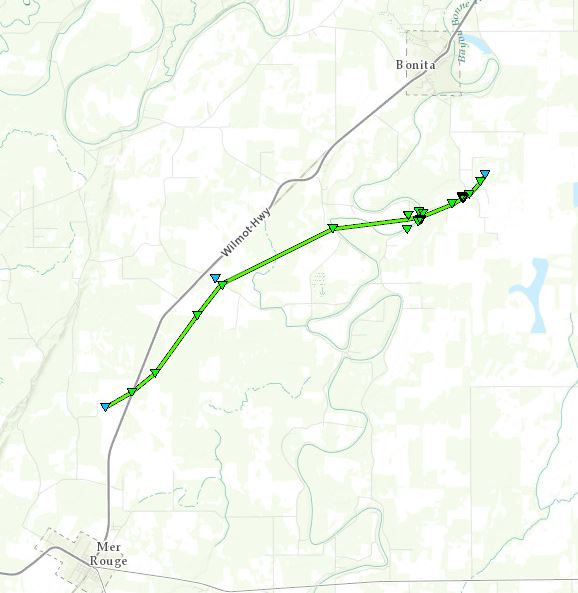
Click on map above to see entire damage point notation and damage pictures at select points.
|
Track Summary
This tornado touched down along Highway 165 where a few power poles were snapped and some trees were snapped just east of the highway. The tornado continued northeast along Highway 165, bending power poles on a tree line before crossing Son Olive Road. Mt. Olive Missionary Baptist Church sustained roof damage, as did a home just west of there. Some of the roof was blown off the church, with tin visible in the field just northeast of the road. A TV antenna was bent at a home just west of there. The tornado continued northeast before crossing Bailey Store Road, where tree damage occurred. It then took more of an east-northeast path before crossing Honeysuckle Lane and Bonne Idee Road. Here the tornado caused roof damage to a home and uprooted and snapped multiple trees, with tin and debris scattered along in the field just to the east. The tornado then crossed Highway 599 where an antenna was collapsed, many large hardwood trees were snapped and uprooted and all were blown to the northeast. A shed building roof was also collapsed at this location. The tornado was at its widest, around 300 yards wide, near this location. It continued east-northeast before hitting a house near the intersection of Highway 599 and Homer McDaniel Road. Here roof damage occurred, tin was blown around, a large metal and PVC tank were blown over. A few large cypress hardwood trees were snapped and blown across the road. It then crossed Homer McDaniel Road where a tree was snapped then crossed near Horace Hill Road where a power pole was broken near the base. The tornado continued east-northeast briefly in the field before lifting.
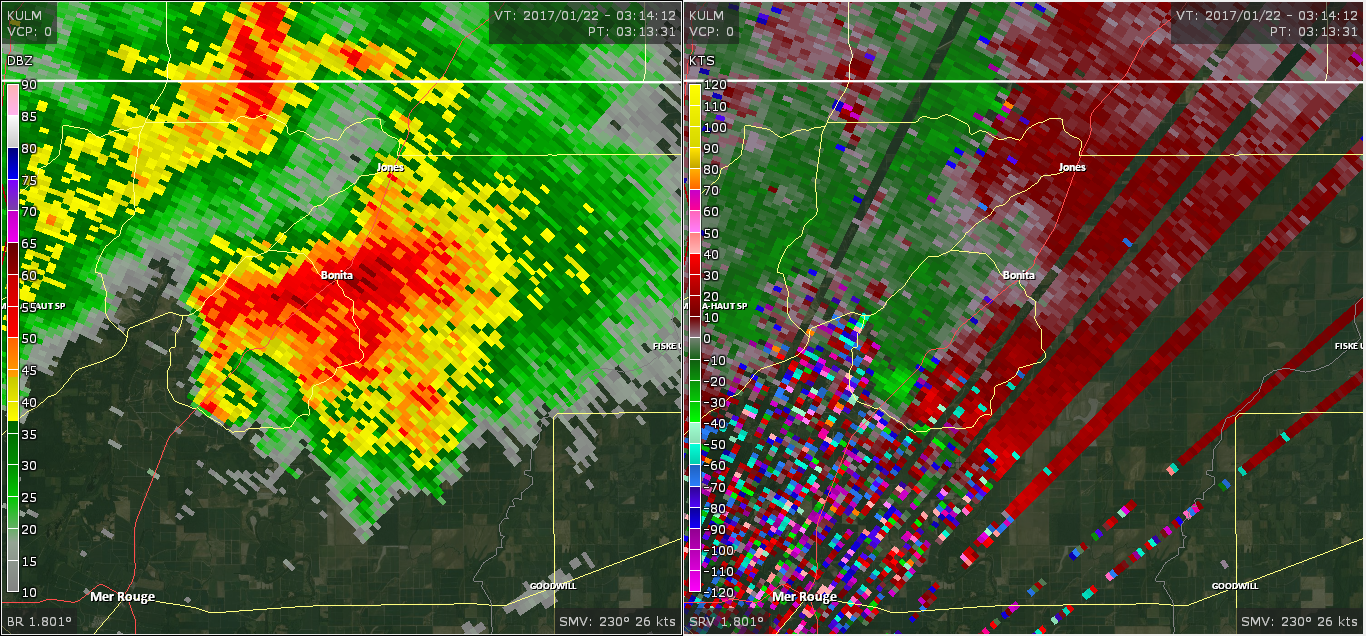
The National Weather Service in Jackson would like to thank the University of Louisiana-Monroe meteorology department for providing data from the new Monroe radar for this tornado event. The damage survey for this tornado was prompted by a tornadic debris signature in the provided radar data. We look forward to forging a continued relationship with ULM meteorology department into the future.
|
Rating:
(Click for EF Scale) |
EF-1 |
| Estimated Maximum Wind: |
105 mph |
| Fatalities/Injuries: |
none |
| Damage Path Length: |
9.25 miles |
| Maximum Path Width: |
300 yards |
| Approximate Start Point/Time: |
3 N Mer Rouge
9:04 pm
|
| Approximate End Point/Time: |
2 SSE Bonita
9:23 pm
|
|
Radar Imagery
These images from the Monroe radar, courtesy of the University of Louisiana-Monroe, show the storm at 9:13 pm as the tornado tracked east of US 165 between Mer Rouge and Bonita. The image on the left shows 1.8° base reflectivity data, and the image on the right shows 1.8° storm relative velocity data. Click on the thumbnail below for a higher resolution image.
Back to the table
Lauderdale EF-2 Tornado
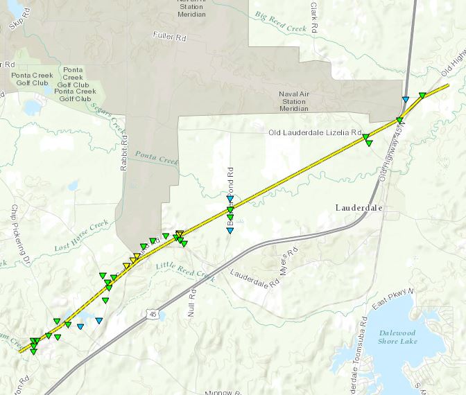
Click on map above to see entire damage point notation and damage pictures at select points.
|
Track Summary
This tornado touched down in a wooded area near Russell Topton Road, snapping trees and powerlines and causing minor roof damage as it crossed the road. The tornado continued northeast onto Lockhart Trailer Court Road and Chip Pickering Drive, where many trees were downed and some structural damage occurred to mobile homes. Here on Lockhart Trailer Court Road, a mobile home was rolled and destroyed, with one minor injury as the resident was thrown out. The tornado continued northeast before crossing Fred Clayton Road and Campground Road. Here the tornado began to widen and more intense damage occurred. Some minor roof damage occurred to a church and numerous trees were snapped, with some causing damage to some structures. As it traveled roughly along Campground Road and the railroad tracks, the tornado became quite large, around a quarter of a mile wide or so. Here significant tree damage, EF2 with winds near 115mph, occurred as nearly every tree were snapped and uprooted. The tornado continued northeast until crossing Green Loop Road. The tornado also was at its strongest at Green Loop as many mobile homes were rolled, with around 4 destroyed. One mobile home was thrown with the undercarriage wrapped around a tree. Here the most intense damage occurred, with winds near 120mph winds. Around 10-11 people were thrown out of mobile homes but thankfully no injuries. The tornado continued before crossing Beaver Pond Road, snapping and uprooting trees. It then continued northeast across a wooded area near Ponta Creek before beginning to weaken and become smaller. It crossed Old Lauderdale Lizelia Road, Highway 45 and then Old Highway 45N, snapping and uprooting trees before lifting northeast in a wooded area.
|
Rating:
(Click for EF Scale) |
EF-2 |
| Estimated Maximum Wind: |
120 mph |
| Fatalities/Injuries: |
Injuries: 1 |
| Damage Path Length: |
7.3 miles |
| Maximum Path Width: |
550 yards |
| Approximate Start Point/Time: |
6 WSW Lauderdale
10:44 pm
|
| Approximate End Point/Time: |
2 NNE Lauderdale
10:54 pm
|
|
Radar Imagery
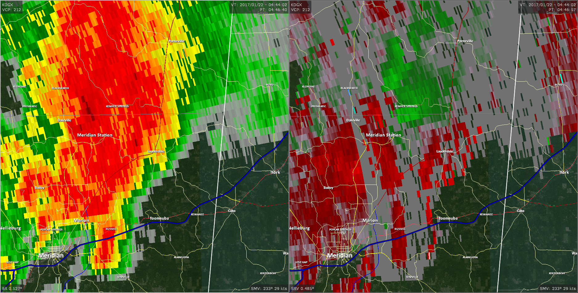
These images from the Brandon, MS Doppler radar show the storm at 10:46 pm as the tornado reached peak intensity west of Lauderdale. The image on the left shows 0.5° base reflectivity data, and the image on the right shows 0.5° storm relative velocity data. Click on the thumbnail below for a higher resolution image.
Back to the table

