Event Summary
Just three days prior to the winter storm, temperatures were in the upper 60s and lower 70s across much of the area ahead of a series of arctic cold fronts. The first arctic front moved through the area during the day on the 5th and ushered in a cooler and drier airmass in its wake as temperatures dropped into the 40s with upper 20s dewpoints. A second reinforcing arctic cold front moved through the ArkLaMiss during the day on the 7th and brought another shot of drier and colder air. A modified continental polar airmass became locked in across the region with a parent 1035 mb high centered over the Southern Plains. As the stronger upper level flow and support pulled away from the southeastern United States, the two arctic cold fronts slowed down and eventually stalled over the northern Gulf of America, helping to establish a strong quasi-stationary front. Further aloft, the synoptic pattern leading up to the winter storm was characterized by an upper level longwave trough centered over the Northern Plains and Great Lakes with multiple shortwave troughs rotating through the Inter-Mountain West and Four Corners region. On the morning of the 7th, a stout shortwave trough was located over the Four Corners and was forecast to eject into the Southern Plains, thus setting the stage for a significant winter storm across the Deep South.
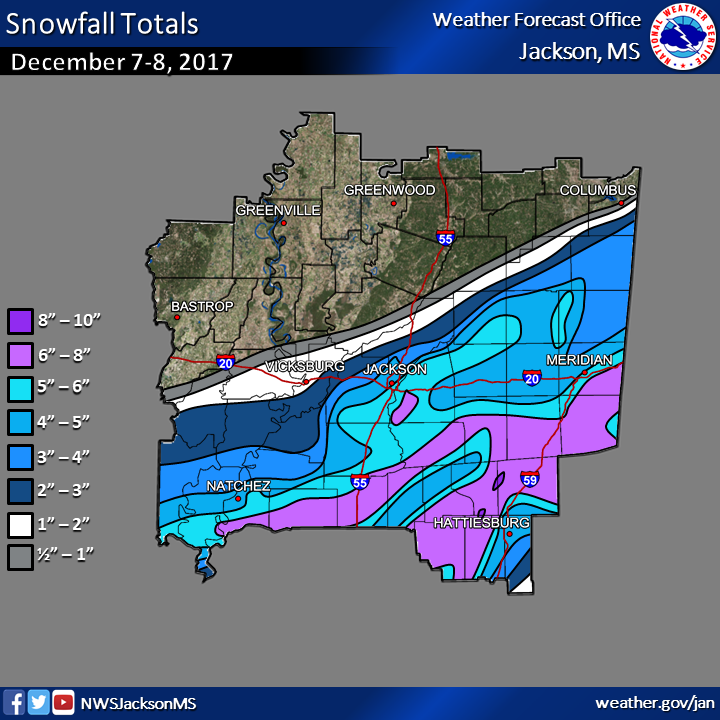
Strong upper-level divergence and ascent ahead of the advancing shortwave trough overspread the northern Gulf of America in the vicinity of the stalled baroclinic zone and helped to induce surface cyclogenesis. The nose of a strengthening jet streak moved into southern Texas as the shortwave progressed into central Texas on the evening of the 7th. The resulting forcing for ascent allowed heavy snowfall to begin accumulating in many locations across Deep South Texas throughout the evening. This snowfall spread across south and east Texas and into Louisiana and Mississippi through the early morning hours on the 8th. Strong isentropic ascent on top of the sloped boundary, working in concert with exceptional upper-level divergence in the right entrance region of an impressive 180 kt jet, allowed heavy snowfall to spread across a large portion of central and southern Mississippi. While surface temperatures were above freezing, evaporational and dynamical cooling due to a dry sub-cloud layer allowed surface temperatures to drop into the low 30s, and heavy snow began accumulating quickly as higher snowfall rates overspread the area through the morning hours. While the heaviest snow accumulations were limited to grassy and elevated surfaces, decent slushy accumulations were able to build on roadways, especially during the highest snowfall rates. Snowfall gradually tapered off from west to east through the day with snow ending in the Jackson metro by mid-morning and eventually ending in the south and east portion of the forecast area by mid-afternoon. The highest storm total snowfall amounts were focused along and southeast of a line from Brookhaven to Meridian where higher snowfall rates were realized in an area of banded snowfall that occurred in the presence of conditional symmetric instability.
The highest snowfall total was 8”, which was reported in two different locations (see totals below), and was part of a heavy swath of widespread 6-7.5” from Brookhaven to Meridian where the aforementioned snow banding occurred. Elsewhere, totals dropped off gradually to the north with 4-6” in the Jackson metro. The official snowfall measurement at the NWS Jackson office was 5.1”, which was high enough to rank as the 7th snowiest day all-time and the largest snowfall since 1982. In Meridian, the total was 5” and was the 3rd highest daily snowfall on record and the largest daily snowfall since 1993. For Hattiesburg, the event total snowfall was 4.1”
Snowfall Totals
Visible Satellite Image
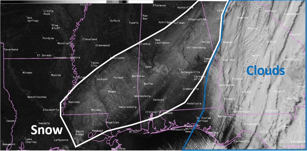
Visible satellite imagery on the morning of 12-9-17 revealed an extensive snow pack across a large portion of the Deep South
Snow Scene at the Mississippi State Capital in Downtown Jackson

Photo Credit: Zander Williamson
Preliminary Snowfall Totals
| |
| |
Location                     Amount

...Louisiana...

...Catahoula Parish...
19 SSW Jonesville            5.0 in
Harrisonburg                 3.0 in

...Concordia Parish...
Vidalia                      4.0 in
Ferriday                     3.0 in
1 ESE Vidalia                2.0 in
1 E Vidalia                  2.0 in

...Franklin Parish...
Winnsboro                    2.0 in
8 W Gilbert                  2.0 in

...Tensas Parish...
Saint Joseph                 3.0 in

...Mississippi...

...Adams County...
11 S Natchez                 6.0 in
4 NE Natchez                 5.0 in
7 NE Natchez                 5.0 in
Natchez                      4.8 in
1 NW Natchez                 3.3 in

...Attala County...
Kosciusko                    0.3 in

...Claiborne County...
Port Gibson                  2.0 in

...Clarke County...
7 ENE Enterprise             7.5 in
Quitman                      6.5 in
1 SE Quitman                 6.0 in
12 ENE Quitman               5.5 in
1 NNE Enterprise             5.0 in

...Copiah County...
1 NE Wesson                  6.0 in
Crystal Springs              5.5 in
Hazlehurst                   4.0 in
7 NW Georgetown              3.0 in

...Covington County...
Seminary                     7.0 in
Collins                      6.5 in
Mount Olive                  3.8 in

...Forrest County...
4 E Petal                    6.0 in
4 SSW Hattiesburg            5.8 in
1 W Hattiesburg              4.8 in
1 WSW Petal                  4.5 in
1 N Hattiesburg              3.4 in
1 NE Hattiesburg             3.0 in

...Franklin County...
1 NE Bude                    7.0 in
Roxie                        5.0 in
McCall Creek                 5.0 in
Meadville                    5.0 in
9 ENE Bude                   5.0 in

...Hinds County...
Byram                        5.5 in
7 N Terry                    5.5 in
Utica                        5.0 in
2 E Raymond                  4.6 in
5 NNE Jackson                4.1 in
7 ESE Raymond                4.0 in
1 ENE Clinton                4.0 in

...Jasper County...
1 WNW Bay Springs            7.0 in
Bay Springs                  7.0 in
8 N Soso                     6.5 in

...Jefferson County...
15 NNE Bude                  5.5 in
Union Church                 5.5 in
1 NNE Fayette                3.0 in

...Jefferson Davis County...
7 N Bassfield                6.5 in
6 N Bassfield                5.0 in
Prentiss                     4.5 in
1 NNE Prentiss               4.0 in

...Jones County...
7 NE Seminary                8.0 in
6 SE Ellisville              7.0 in
5 E Laurel                   7.0 in
7 E Seminary                 7.0 in
Laurel                       6.0 in
Ellisville                   6.0 in
7 NNW Petal                  6.0 in
6 WNW Ellisville             6.0 in
4 W Laurel                   5.0 in
3 WNW Ellisville             5.0 in
9 ESE Laurel                 5.0 in
8 NNW Petal                  4.5 in
4 W Laurel                   4.0 in

...Kemper County...
13 NW De Kalb                5.5 in
8 NNW Collinsville           5.0 in
12 E Tucker                  4.0 in
De Kalb                      3.5 in
1 E Scooba                   3.0 in
5 NE Scooba                  3.0 in

...Lamar County...
1 NNE Sumrall                8.0 in
10 NW Lumberton              7.5 in
5 S Sumrall                  7.5 in
Sumrall                      7.0 in
9 SSW Sumrall                7.0 in
2 W West Hattiesburg         7.0 in
Purvis                       6.0 in
5 SW West Hattiesburg        6.0 in
3 SW West Hattiesburg        5.0 in
1 NE West Hattiesburg        4.6 in

...Lauderdale County...
6 SE Meridian                7.3 in
12 E Marion                  7.0 in
9 NE Enterprise              7.0 in
10 SE Meridian               6.5 in
8 E Marion                   6.0 in
3 ESE Marion                 6.0 in
12 SE Meridian               6.0 in
1 SSE Meridian               5.0 in
4 SSE Meridian               5.0 in
3 SW Meridian                3.5 in
1 NW Collinsville            3.5 in
Collinsville                 3.0 in
4 NNE Collinsville           2.7 in

...Lawrence County...
11 SSE Silver Creek          5.5 in
Silver Creek                 5.0 in
11 S Monticello              5.0 in
14 SSW Monticello            5.0 in
Monticello                   4.7 in

...Leake County...
Carthage                     4.8 in
9 NNE RedWater               3.0 in

...Lincoln County...
3 N Brookhaven               6.0 in
7 WNW Brookhaven             5.0 in
6 SSE Wesson                 5.0 in
Brookhaven                   4.0 in

...Lowndes County...
9 S New Hope                 3.5 in
1 NNW New Hope               2.0 in
4 ENE Artesia                0.1 in

...Madison County...
6 NW Madison                 4.5 in
2 E Madison                  4.5 in
Ridgeland                    4.0 in
Madison                      3.2 in
5 WNW Madison                3.0 in
Canton                       2.3 in
1 SSE Flora                  2.0 in
6 NW Madison                 1.3 in

...Marion County...
Columbia                     6.0 in
15 S Columbia                5.5 in
10 WSW Columbia              4.0 in

...Neshoba County...
8 S Pearl River              5.0 in
1 WNW Philadelphia           4.0 in
1 SE Philadelphia            3.8 in
5 E Philadelphia             3.5 in
5 ENE Philadelphia           3.5 in
3 N Union                    3.5 in
5 SSW Noxapater              3.5 in
Philadelphia                 2.5 in

...Newton County...
2 W Union                    4.0 in
1 W Union                    4.0 in
Decatur                      3.5 in
Hickory                      2.0 in

...Noxubee County...
10 W Macon                   3.5 in
8 WNW Crawford               2.0 in
Brooksville                  0.1 in

...Oktibbeha County...
8 WNW Crawford               2.0 in

...Rankin County...
1 NNW Pearl                  6.0 in
5 S Brandon                  6.0 in
4 SE Florence                6.0 in
Pearl                        6.0 in
8 S Florence                 5.8 in
2 W Pearl                    5.5 in
3 NNE Brandon                5.5 in
6 N Brandon                  5.5 in
2 E Flowood                  5.1 in
2 ESE Brandon                5.1 in
Florence                     5.0 in
Richland                     5.0 in
3 ESE Pearl                  5.0 in
6 ESE Madison                5.0 in
2 NE Brandon                 5.0 in
3 WSW Brandon                5.0 in
5 NE Flowood                 4.8 in
4 SW Brandon                 4.5 in
3 ENE Brandon                4.5 in
3 NE Flowood                 4.3 in
Pelahatchie                  4.0 in

...Scott County...
3 SSW Walnut Grove           5.0 in
2 SSW Forest                 4.0 in

...Simpson County...
Mendenhall                   6.5 in
Magee                        6.0 in
8 S Florence                 5.8 in
Braxton                      5.5 in
7 WSW Braxton                3.5 in

...Smith County...
Taylorsville                 6.8 in
1 SSE Raleigh                6.0 in
Raleigh                      5.5 in
Mize                         5.0 in
11 E Polkville               3.5 in
10 SSW Forest                3.5 in

...Warren County...
7 W Edwards                  3.0 in
12 S Vicksburg               2.5 in
7 NE Vicksburg               1.5 in
2 N Vicksburg                1.0 in

...Winston County...
Nanih Waiya                  4.0 in
8 SE Noxapater               4.0 in
Noxapater                    3.5 in
1 ENE Louisville             2.0 in

...Yazoo County...
Bentonia                     1.0 in
|
| |
|
Observations are collected from a variety of sources with varying
equipment and exposures. We thank all volunteer weather observers
for their dedication. Not all data listed are considered official.

