March 28, 2018 Severe Weather Event
Event Summary
A mid-level disturbance moving over the Southern Plains coupled with a cold front at the surface over the ArkLaTex region led to a fairly widespread area of severe weather across portions of Louisiana and Mississippi during the afternoon of March 28th through the morning of March 29th. Storms initially developed near the front early in the day on the 28th before expanding in coverage and moving eastward through the afternoon hours. The air mass ahead of the front during the afternoon was characterized by dewpoints in the mid- to upper-60s along with a strengthening low-level jet providing continued moisture and sufficient low-level shear for the development of severe thunderstorms and a few tornadoes.
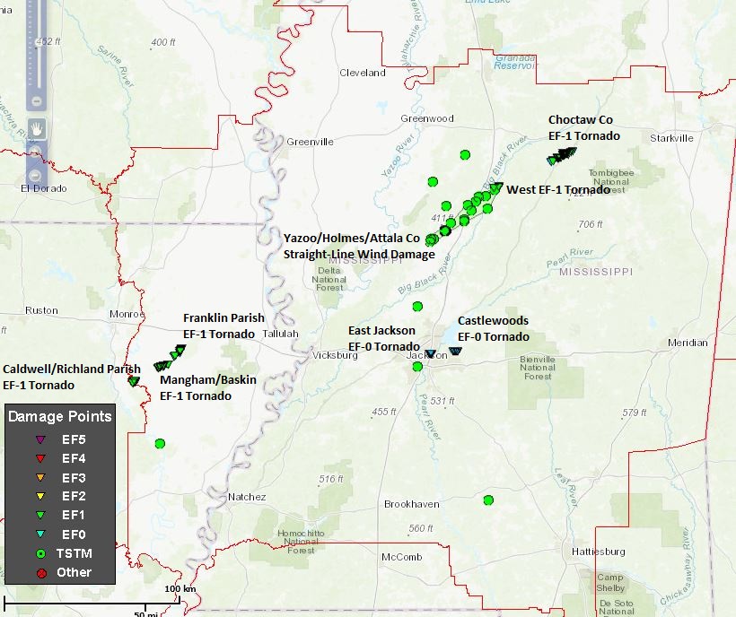
Severe storms initially pushed into the NWS Jackson forecast area during the mid- to late-afternoon hours of March 28th. In northeastern Louisiana, three tornadoes affected Richland and Franklin parishes, with four injuries occurring when an EF-1 tornado flipped a mobile home on its side near Mangham, injuring its occupants. These storms eventually evolved into part of a larger Quasi-Linear Convective System (QLCS) that moved east into Mississippi, producing wind damage along and north of the Interstate 20 corridor extending north and east across portions of the Interstate 55 corridor through much of central and north-central Mississippi. Four tornadoes occurred in Mississippi, which included two brief EF-0 tornadoes that affected parts of Hinds and Rankin counties east of the Jackson metro area. Two EF-1 tornadoes affected Choctaw and Attala counties. Wind damage was also reported in several additional counties across the ArkLaMiss region during the evening and overnight period along with a few reports in the Pine Belt region during the morning of March 29th.
A cold front eventually moved through and cleared the area from the northwest by the early morning hours of Friday, March 30th, although the severe threat had largely ended by midday on the 29th.
Tornado/Straight line Wind Damage Map
Local Storm Reports
Click on the map for additional details.
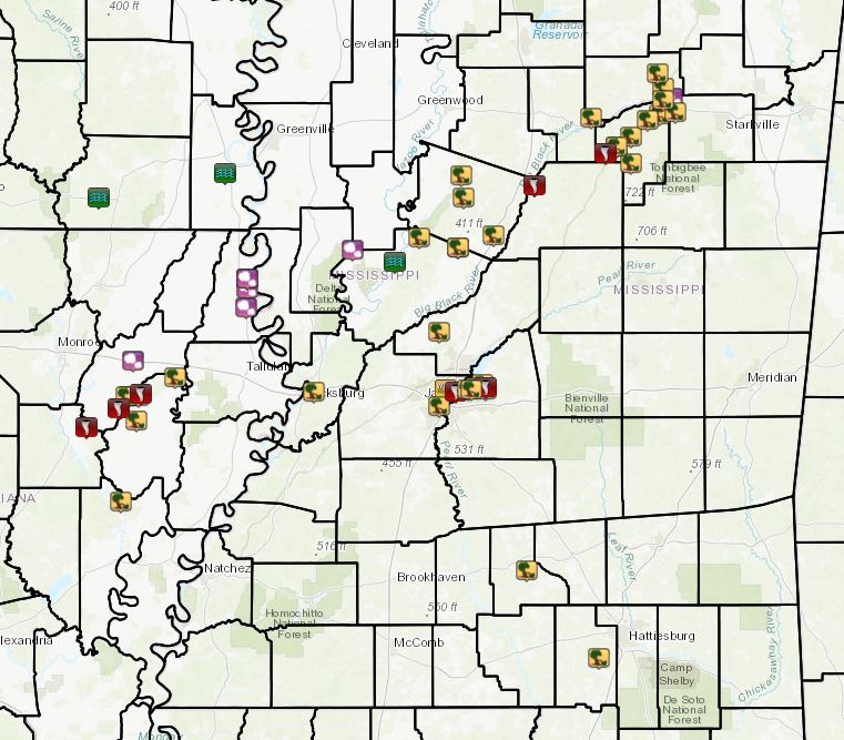

Click on the location in the table for additional maps and details below.
| Location | Start/ End Time |
Event Type | Fatalities/ Injuries |
Path Length | Path Width |
| Richland Parish 8 NE Columbia to 9 NE Columbia |
4:49 PM - 4:51 PM |
EF-1 Tornado 95 mph |
none | 1.77 miles | 400 yards |
| Richland/Franklin parishes 4 SSW Mangham to 1 NNW Baskin |
5:01 PM - 5:05 PM |
EF-1 Tornado 105 mph |
Injuries: 4 | 4.16 miles | 650 yards |
| Franklin Parish 4 ENE Mangham to 7 ENE Mangham |
5:08 PM - 5:12 PM |
EF-1 Tornado 100 mph |
none | 3.92 miles | 400 yards |
| Attala County 1 ESE West to 3 E West |
8:03 PM - 8:06 PM |
EF-1 Tornado 90 mph |
none | 1.88 miles | 50 yards |
| Choctaw County 2 NNW French Camp to 7 WNW Ackerman |
8:28 PM - 8:38 PM |
EF-1 Tornado 110 mph |
none | 8.63 miles | 800 yards |
| Hinds County 3 WNW Flowood to 2 WNW Flowood |
8:58 PM - 8:59 PM |
EF-0 Tornado 75 mph |
none | 0.8 miles | 25 yards |
| Rankin County 5 N Brandon to 5 NNE Brandon |
9:12 PM - 9:16 PM |
EF-0 Tornado 75 mph |
none | 1.68 miles | 50 yards |
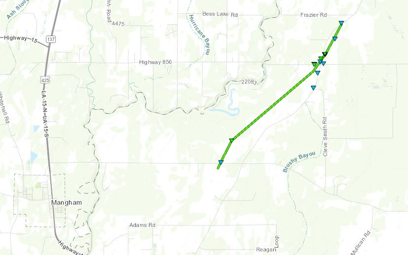
Richland Parish/Woolen Lake EF-1 Tornado
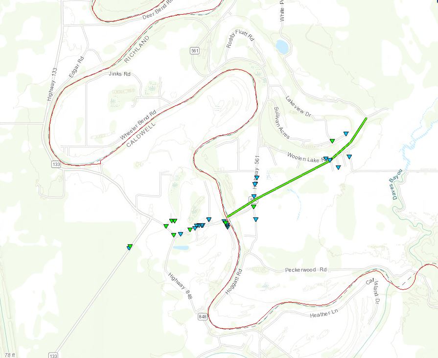
Click on map above to see entire damage point notation and damage pictures at select points.
|
Track Summary This tornado crossed the Boeuf River into Richland Parish along Highway 561 at Hebert. Tin from a shed in Caldwell Parish was blown across the river onto the eastern bank. Along Highway 561, multiple trees were snapped or uprooted, and a mobile home sustained damage to its deck and skirting. The tornado continued along the south end of Woolen Lake, downing additional trees and large tree limbs, some of which damaged houses, sheds, and campers. A fence was also blown down in this area. The tornado lifted shortly thereafter. |
|
Richland/Franklin Parish EF-1 Tornado
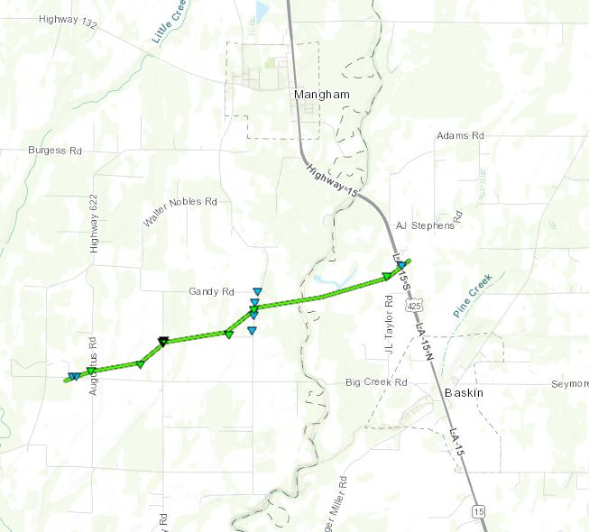
Click on map above to see entire damage point notation and damage pictures at select points.
|
Track Summary This tornado began around the intersection of Bill Taylor Road and Augustus Road. The tornado was videoed as it continued east-northeast across a field north of Bill Taylor Road, where it overturned an irrigation pivot. The tornado then crossed Middle Road, where it flipped a mobile home on its side and atop a vehicle. Four occupants of the mobile home sustained minor injuries. Numerous trees were snapped at this location as well. The tornado reached its widest point as it continued eastward across Newlight Road, causing minor damage to two mobile homes and a shed, as well as damaging the roof of another house. The tornado then crossed Big Creek into Franklin Parish, and ended as it crossed US 425 just north of Baskin. Here, trees were damaged and a home sustained minor damage. |
|
Click on map above to see entire damage point notation and damage pictures at select points.
|
Track Summary This tornado began along LA Highway 132 near the intersection with Union Church Road and Highway 857. It tracked northeast across a farm, overturning an irrigation pivot. It then paralleled Highway 132 from around Bobby Woods Road and Piney Woods Road north northeastward. Several sheds were damaged or destroyed in this area, and several trees were snapped or uprooted. A home received roof damage as well. The tornado lifted along Highway 132 before reaching Frazier Road. |
|
Click on map above to see entire damage point notation and damage pictures at select points.
|
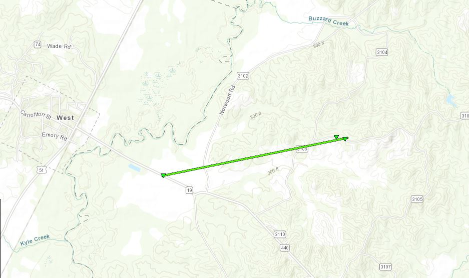
Track Summary This tornado started out near Highway 19 before the intersection with Highway 440 where it uprooted numerous hardwood trees. It tracked east northeast across Norwood Road and then along Highway 3106, where it uprooted several trees before lifting. |
|
Click on map above to see entire damage point notation and damage pictures at select points.
|
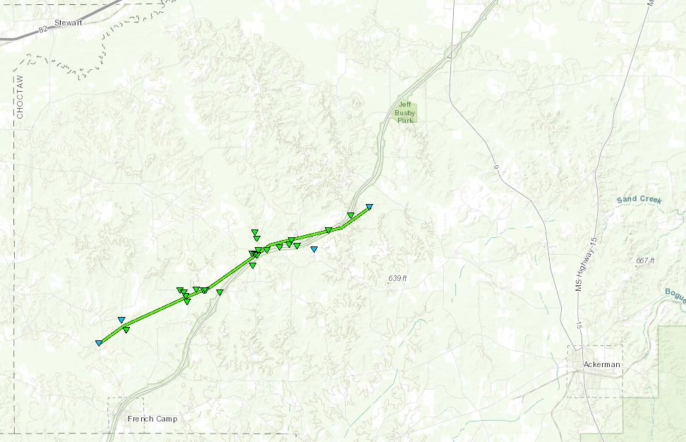
Track Summary This tornado began near the intersection of Dendy Road and MS Highway 413 where it snapped multiple large tree limbs. The tornado proceeded northeast toward the Natchez Trace where it first crossed Whites Road and uprooted several trees. The strongest winds occurred as the tornado passed over Miller and Rabun roads, and continued along the Natchez Trace Parkway near Stewart Weird Road and Hamrick Road. Numerous large softwood and hardwood trees were uprooted and snapped through this area where winds were estimated at 110 mph. The tornado continued along the Natchez Trace to near Rex Road, causing sporadic tree damage with a few trees snapped and uprooted. The tornado quickly weakened and dissipated over a wooded area south of the Natchez Trace Parkway but before reaching Chester Tomnolen Road. |
|
Click on map above to see entire damage point notation and damage pictures at select points.
|
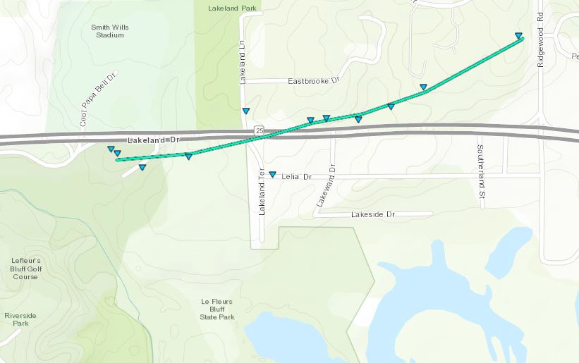
Track Summary This brief, weak tornado developed along Lakeland Drive on the north end of LeFleurs Bluff Golf Course and traveled east along Lakeland Drive, ending near Ridgewood Road. Along the path, a few trees were uprooted and multiple trees were topped, mainly on the north end of Lakeland Drive. Window awnings were damaged at a professional building on Lelia Drive. |
|
Click on map above to see entire damage point notation and damage pictures at select points.
|
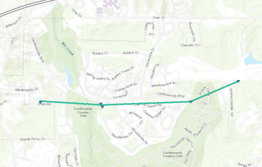
Track Summary This tornado began near the intersection of Branbury Court and Rusk Road in the Castlewoods community, where it downed a couple of small trees. The tornado traveled east across the Castlewoods Golf Course, where it snapped a hardwood tree and also uprooted a tree. The tornado continued moving east just south of Castlewoods Blvd, snapping limbs along the way. The tornado ended just past Willow Grand Circle, where it snapped some more limbs and threw a trampoline into the trees. |
|

