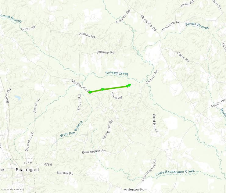
.Beauregard Tornado...

Rating:                 EF1
Estimated Peak Wind:    100 mph
Path Length /statute/:  1.4 miles
Path Width /maximum/:   100 yards
Fatalities:             0
Injuries:               0

Start Date:             3/16/2021
Start Time:             7:03 PM CDT
Start Location:         3 NE Beauregard / Copiah County / MS
Start Lat/Lon:          31.7611 / -90.3494

End Date:               3/16/2021
End Time:               7:05 PM CDT
End Location:           4 NE Beauregard / Copiah County / MS
End Lat/Lon:            31.7647 / -90.3261

Summary: This brief tornado started at Martinsville road and
tracked ENE for almost a mile. It also moved along a portion of
Ryan Rd. Damage was mainly snapped trees, uprooted trees and many
limbs broken. Some power lines were down as well. High resolution
satellite imagery showed additional tree damage occurring to the
east of these points, to the north of Ryan Rd and west of Deason
Rd. The tornado is believed to have lifted before reaching Deason
Rd.
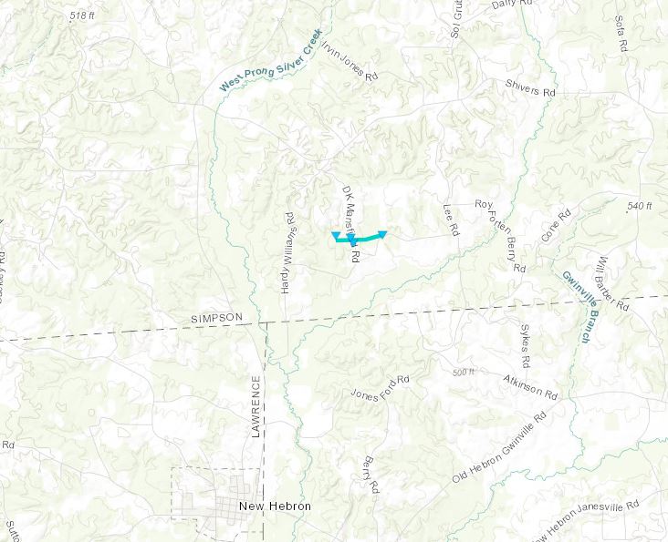
.Simpson County Tornado...

Rating:                 EF0
Estimated Peak Wind:    75 mph
Path Length /statute/:  0.522 miles
Path Width /maximum/:   50.0 yards
Fatalities:             0
Injuries:               0

Start Date:             03/16/2021
Start Time:             07:58 PM CDT
Start Location:         3 NNE New Hebron / Simpson County / MS
Start Lat/Lon:          31.7748 / -89.9611

End Date:               03/16/2021
End Time:               07:59 PM CDT
End Location:           3 NNE New Hebron / Simpson County / MS
End Lat/Lon:            31.7755 / -89.9523

Summary: This brief EF0 tornado touched down off DK Mansfield at
Tip Buckley road. A few trees were damaged with some minor tin
roof damage to a home and barn. The tornado moved east into a
field were a few more trees were downed, then dissipated. Max
winds were 75 mph, width 50 yds, length was 0.5 miles.
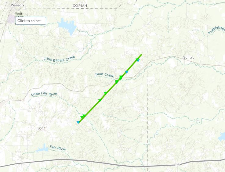
.Lincoln County Tornado...

Rating:                 EF1
Estimated Peak Wind:    95 mph
Path Length /statute/:  6.1621 miles
Path Width /maximum/:   120.0 yards
Fatalities:             0
Injuries:               0

Start Date:             03/17/2021
Start Time:             01:16 PM CDT
Start Location:         7 E Brookhaven / Lincoln County / MS
Start Lat/Lon:          31.5903 / -90.3218

End Date:               03/17/2021
End Time:               01:27 PM CDT
End Location:           9 ESE Wesson / Lincoln County / MS
End Lat/Lon:            31.6559 / -90.2507

Summary: This EF1 tornado touched down at the intersection of Old
Malcum and Hopewell Road and tracked northeast for just over 6
miles. Damage along the path consisted of many uprooted and
snapped trees, along with multiple large limbs broken. Along the
path, the tornado crossed Nola, Autry, Sandifer and Cotton roads.
Along Cotton at the intersection with the rail road track, one
home had half the roof taken off. Before dissipating, the tornado
crossed Pine Grove road, here a couple mobile homes had the
skirting blown out, several sheds were damaged and multiple trees
were down. The tornado dissipated shortly after this location. Max
winds were 95 mph and width was 125 yds.
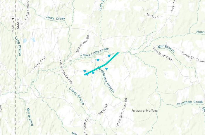
.Lamar County Tornado...

Rating:                 EF0
Estimated Peak Wind:    80 mph
Path Length /statute/:  1.4224 miles
Path Width /maximum/:   300.0 yards
Fatalities:             0
Injuries:               0

Start Date:             03/17/2021
Start Time:             06:16 PM CDT
Start Location:         12 W Purvis / Lamar County / MS
Start Lat/Lon:          31.1532 / -89.613

End Date:               03/17/2021
End Time:               06:17 PM CDT
End Location:           11 W Purvis / Lamar County / MS
End Lat/Lon:            31.1646 / -89.5932

Summary: This brief and weak tornado touched down near Carroll
and Caney Church road. A few trees were down and a couple sheds
were destroyed. Damage was blown across a field in a northward
direction. The tornado moved to the northeast and crossed
Chambliss and H Thompson roads. On Chambliss, a home had most of
the roof taken off and a mobile home had a tree fall through half
of it. The tornado dissipated just after crossing Thompson road.
Total length was just over 1 mile, width was 300 yds and max winds
80 mph.
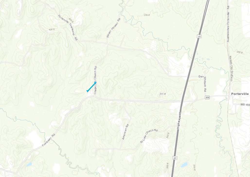
.Kemper County Tornado...

Rating:                 EF0
Estimated Peak Wind:    75 mph
Path Length /statute/:  0.2338 miles
Path Width /maximum/:   80.0 yards
Fatalities:             0
Injuries:               0

Start Date:             03/17/2021
Start Time:             07:56 PM CDT
Start Location:         9 ESE De Kalb / Kemper County / MS
Start Lat/Lon:          32.689 / -88.5223

End Date:               03/17/2021
End Time:               07:57 PM CDT
End Location:           9 ESE De Kalb / Kemper County / MS
End Lat/Lon:            32.6915 / -88.5195

Summary: This brief EF0 touched down near the intersection of
Fire Tower and Chapel Hill roads. Ground survey and drone footage
showed some trees damaged by being uprooted or having broken
limbs. Many thanks to the NSSL research group for the survey.

